
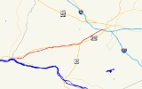
Maryland Route 180
Encyclopedia
Maryland Route 180 is a state highway
in the U.S. state of Maryland
. Known for most of its length as Jefferson Pike, the state highway runs 14.95 miles (24.1 km) from U.S. Route 340
(US 340) in Knoxville
east to MD 351
and Interstate 70
(I-70) in Frederick
. MD 180 is the old alignment of US 340 through Knoxville, Petersville, and Jefferson
in the Middletown Valley
of western Frederick County
. The state highway was originally constructed in the early 1910s and designated US 340 in 1927. MD 180 was assigned to the highway bypassed by the US 340 freeway between Sandy Hook
in far southern Washington County
and Jefferson in the mid 1960s. The state highway was extended east to Frederick and south along what is now MD 351 after the US 340 freeway was completed in the late 1960s. MD 180 was rolled back to Frederick and removed from Washington County in 1989.
and CSX
's Metropolitan Subdivision to the village of Knoxville. MD 180 makes a sharp curve to the northeast in which the highway intersects MD 478
(Knoxville Road), which parallels the railroad, canal, and river east to Brunswick
. MD 180 is part of the National Highway System
between US 340 and MD 478 as part of an intermodal
connection with the Brunswick
train station on MARC
's Brunswick Line
.
MD 180 heads northeast and temporarily gains an eastbound climbing lane as it leaves the narrow Potomac River valley. The state highway passes through farmland and meets MD 17
(Burkittsville Road) at a roundabout
west of Rosemont. MD 180 crosses Little Catoctin Creek on its way to Petersville, where the highway meets the northern end of MD 79
(Petersville Road). East of Petersville, the state highway has a diamond interchange
with US 340. MD 180 descends into the narrow valley of Catoctin Creek
; the westbound direction has a short climbing lane. The state highway curves north to cross the creek, then curves back east and leaves the creek valley. MD 180 has a single ramp to westbound US 340 and meets the southern end of MD 383
(Broad Run Jefferson Road) before passing through Jefferson. The state highway intersects Old Middletown Road, which heads north past the George Willard House
, and Holter Road and Lander Road; Holter Road heads north toward Middletown
and Lander Road heads south from the same intersection toward an interchange with US 340.
MD 180 parallels US 340 through a wide gap in Catoctin Mountain
and continues northeast to the hamlet of Feagaville, where the highway intersects Mt. Zion Road and traverses Ballenger Creek
. MD 180 crosses over I-70 (Eisenhower Memorial Highway) and intersects Butterfly Lane near Saint John's Catholic Prep
before beginning a sweeping curve to the south. The state highway intersects Himes Avenues, which is unsigned MD 180B and leads to a ramp to westbound US 340 and US 15
, at the same intersection as a ramp from that direction of the freeway. MD 180 crosses over US 340 and US 15 and receives a ramp from the eastbound direction of the freeway, then intersects Solarex Court and a ramp to the eastbound freeway that indirectly provides access to westbound I-70. Solarex Court provides access to a business park in the triangle formed by I-70, Jefferson National Pike, and the Frederick Freeway; this business park includes the historic home Linden Grove
. MD 180 continues south as Ballenger Creek Pike, passing under I-70 before reaching its eastern terminus at Ballenger Center Parkway and a ramp to eastbound I-70 and I-270. Ballenger Creek Pike continues south as MD 351 through the suburb of Ballenger Creek
.
The first portion of the US 340 freeway to open was between the MD 180 interchange east of Petersville and the ramp from MD 180 west of Jefferson was opened, replacing the curvaceous old alignment at Catoctin Creek. The present alignment of US 340 opened as a four-lane divided highway from the Valley Road / Keep Tryst Road intersection in Sandy Hook east to Weverton also opened that year. The portion of the freeway between Weverton and MD 180 east of Petersville was under construction in 1964 and completed in 1965. MD 180 was assigned to old US 340 from Sandy Hook to west of Jefferson in 1965. By 1967, MD 180 became a split route; MD 180A was assigned to Keep Tryst Road between its intersections with US 340 in Sandy Hook and Weverton.
Construction on the US 340 freeway from Jefferson toward Frederick began in 1966. US 340's interchanges with I-70 and MD 180 were completed in 1968 and the portion of the freeway from Jefferson east to the MD 180 interchange opened in 1969. At that time, MD 180 was extended east through Jefferson to the US 340 interchange in Frederick, which also served the northern end of MD 78. MD 180 was extended south over the length of MD 78 (Ballenger Creek Pike) toward Adamstown
in 1970, forming a cane-shaped route. MD 180 was retracted to the US 340 interchange in 1989 when MD 351 was assigned to what had been MD 78. That same year, Keep Tryst Road was removed from the state highway system, leaving behind the stub that is current MD 180A. In 2002, MD 180 was extended east along Ballenger Creek Pike to Ballenger Center Parkway at the same time MD 351 was temporarily transferred to county maintenance south of its ramp to eastbound I-70.
.
{|class=wikitable
!Location
!Mile
!Intersection
!Notes
|-
|rowspan=2|Knoxville
|0.00
|
|Western terminus; westbound entrance to and eastbound exit from US 340
|-
|0.42
|
|
|-
|Rosemont
|2.12
|
|Roundabout
|-
|rowspan=2|Petersville
|3.81
|
|
|-
|5.47
|
|US 340 Exit 4
|-
|rowspan=2|Jefferson
|6.97
|
|Entrance to westbound US 340 only
|-
|7.67
|
|
|-
|rowspan=3|Frederick
|14.36
|Himes Avenue north to
|Himes Avenue is unsigned MD 180B; south leg of intersection is ramp from westbound US 15 / US 340
|-
|14.63
|
|
|-
|14.95
|
|Eastern terminus at northern terminus of MD 351; ramp from MD 180 to eastbound I-70
.
State highway
State highway, state road or state route can refer to one of three related concepts, two of them related to a state or provincial government in a country that is divided into states or provinces :#A...
in the U.S. state of Maryland
Maryland
Maryland is a U.S. state located in the Mid Atlantic region of the United States, bordering Virginia, West Virginia, and the District of Columbia to its south and west; Pennsylvania to its north; and Delaware to its east...
. Known for most of its length as Jefferson Pike, the state highway runs 14.95 miles (24.1 km) from U.S. Route 340
U.S. Route 340 in Maryland
U.S. Route 340 is a part of the U.S. Highway System that runs from Greenville, Virginia to Frederick, Maryland. In Maryland, the U.S. highway runs from the Virginia state line at the Potomac River at Sandy Hook east to its northern terminus at US 15 and US 40 in Frederick...
(US 340) in Knoxville
Knoxville, Maryland
Knoxville is an unincorporated community in Washington County, Maryland, United States.-References:...
east to MD 351
Maryland Route 351
Maryland Route 351 is a state highway in the U.S. state of Maryland. Known as Ballenger Creek Pike, the state highway runs from the beginning of state maintenance near Adamstown north to MD 180 and Interstate 70 in Frederick. MD 351 connects Frederick with its suburb of Ballenger Creek and the...
and Interstate 70
Interstate 70 in Maryland
Interstate 70 is a part of the Interstate Highway System that runs from Cove Fort, Utah to Baltimore, Maryland. In Maryland, the Interstate Highway runs from the Pennsylvania state line in Hancock east to the Interstate's eastern terminus near its junction with I-695 at a park and ride in...
(I-70) in Frederick
Frederick, Maryland
Frederick is a city in north-central Maryland. It is the county seat of Frederick County, the largest county by area in the state of Maryland. Frederick is an outlying community of the Washington-Arlington-Alexandria, DC-VA-MD-WV Metropolitan Statistical Area, which is part of a greater...
. MD 180 is the old alignment of US 340 through Knoxville, Petersville, and Jefferson
Jefferson, Maryland
Jefferson is an unincorporated community located in Frederick County, Maryland, established in 1774, incorporated as a town in 1831. However, a year later, in 1832, the citizens of the town decided that municipal government was unnecessary, thus, it was disincorporated.- History of Jefferson...
in the Middletown Valley
Middletown Valley
Middletown Valley, also historically known as Catoctin Valley, is a valley in western Frederick County in the state of Maryland.-Geography:...
of western Frederick County
Frederick County, Maryland
Frederick County is a county located in the western part of the U.S. state of Maryland, bordering the southern border of Pennsylvania and the northeastern border of Virginia. As of the 2010 Census, the population was 233,385....
. The state highway was originally constructed in the early 1910s and designated US 340 in 1927. MD 180 was assigned to the highway bypassed by the US 340 freeway between Sandy Hook
Sandy Hook, Maryland
Sandy Hook is an unincorporated community in Washington County, Maryland, United States.-References:...
in far southern Washington County
Washington County, Maryland
Washington County is a county located in the western part of the U.S. state of Maryland, bordering southern Pennsylvania to the north, northern Virginia to the south, and the Eastern Panhandle of West Virginia to the south and west. As of the 2010 Census, its population is 147,430...
and Jefferson in the mid 1960s. The state highway was extended east to Frederick and south along what is now MD 351 after the US 340 freeway was completed in the late 1960s. MD 180 was rolled back to Frederick and removed from Washington County in 1989.
Route description
MD 180 begins at a partial interchange with US 340 (Jefferson National Pike) just east of the southern end of South Mountain at the Potomac River. There is no access from westbound MD 180 to eastbound US 340 or from westbound US 340 to eastbound MD 180. The state highway heads east as two-lane Jefferson Pike, which parallels the Chesapeake and Ohio CanalChesapeake and Ohio Canal
The Chesapeake and Ohio Canal, abbreviated as the C&O Canal, and occasionally referred to as the "Grand Old Ditch," operated from 1831 until 1924 parallel to the Potomac River in Maryland from Cumberland, Maryland to Washington, D.C. The total length of the canal is about . The elevation change of...
and CSX
CSX Transportation
CSX Transportation operates a Class I railroad in the United States known as the CSX Railroad. It is the main subsidiary of the CSX Corporation. The company is headquartered in Jacksonville, Florida, and owns approximately 21,000 route miles...
's Metropolitan Subdivision to the village of Knoxville. MD 180 makes a sharp curve to the northeast in which the highway intersects MD 478
Maryland Route 478
Maryland Route 478 is a state highway in the U.S. state of Maryland. Known as Knoxville Road, the state highway runs from MD 180 in Knoxville east to Florida Avenue in Brunswick. MD 478 was constructed as MD 70 in the late 1920s. In 1950, MD 70 was replaced with an extended MD 464...
(Knoxville Road), which parallels the railroad, canal, and river east to Brunswick
Brunswick, Maryland
Brunswick is a city in Frederick County, Maryland, United States. The population was 5,870 at the 2010 census.- History :The area now known as Brunswick was originally home to the Susquehanna Indians. In 1728 the first settlement was built, and the region became known as Eel Town, because the...
. MD 180 is part of the National Highway System
National Highway System (United States)
The National Highway System is a network of strategic highways within the United States, including the Interstate Highway System and other roads serving major airports, ports, rail or truck terminals, railway stations, pipeline terminals and other strategic transport facilities.Individual states...
between US 340 and MD 478 as part of an intermodal
Intermodal passenger transport
Intermodal passenger transport involves more than one mode of transport of passengers. Some modes of transportation have always been intermodal; for example, most major airports have extensive facilities for automobile parking and have good rail or bus connections to the cities nearby. Urban bus...
connection with the Brunswick
Brunswick (MARC station)
Brunswick is a passenger rail station on the MARC Brunswick Line between Washington, D.C. and Martinsburg, West Virginia. The station house, located at 100 South Maple Street in Brunswick, Maryland, is a former Baltimore and Ohio Railroad depot that is a contributing property to the Brunswick...
train station on MARC
MARC Train
MARC , known prior to 1984 as Maryland Rail Commuter Service, is a regional rail system comprising three lines in the Baltimore-Washington Metropolitan Area. MARC is administered by the Maryland Transit Administration , a Maryland Department of Transportation agency, and is operated under contract...
's Brunswick Line
Brunswick Line
The Brunswick Line is a MARC commuter rail line consisting of a main line running from Washington D.C. to Martinsburg, West Virginia and a branch line from just south of Point-of-Rocks station to Frederick, Maryland. The service is operated under contract by CSX Transportation, but is administered...
.
MD 180 heads northeast and temporarily gains an eastbound climbing lane as it leaves the narrow Potomac River valley. The state highway passes through farmland and meets MD 17
Maryland Route 17
Maryland Route 17 is a state highway in the U.S. state of Maryland. The state highway begins at the Virginia state line at the Potomac River in Brunswick, where the highway continues south as Virginia State Route 287 . MD 17 runs north from the Brunswick Bridge to the Frederick–Washington...
(Burkittsville Road) at a roundabout
Roundabout
A roundabout is the name for a road junction in which traffic moves in one direction around a central island. The word dates from the early 20th century. Roundabouts are common in many countries around the world...
west of Rosemont. MD 180 crosses Little Catoctin Creek on its way to Petersville, where the highway meets the northern end of MD 79
Maryland Route 79
Maryland Route 79 is a state highway in the U.S. state of Maryland. Known as Petersville Road, the state highway runs from MD 17 and MD 464 in Rosemont north to MD 180 in Petersville. MD 79 and the adjacent portion of MD 17 south to Brunswick were constructed in 1916...
(Petersville Road). East of Petersville, the state highway has a diamond interchange
Diamond interchange
A diamond interchange is a common type of road junction, used where a freeway crosses a minor road. The freeway itself is grade-separated from the minor road, one crossing the other over a bridge...
with US 340. MD 180 descends into the narrow valley of Catoctin Creek
Catoctin Creek (Maryland)
Catoctin Creek is a tributary of the Potomac River in Frederick County, Maryland, USA. Its source is formed in the Myersville, MD area and flows directly south for the entire length of the stream. Catoctin Creek enters the Potomac River east of Brunswick. The stream flows through Catoctin Creek...
; the westbound direction has a short climbing lane. The state highway curves north to cross the creek, then curves back east and leaves the creek valley. MD 180 has a single ramp to westbound US 340 and meets the southern end of MD 383
Maryland Route 383
Maryland Route 383 is a state highway in the U.S. state of Maryland. Known as Broad Run Road, the state highway runs from MD 180 in Jefferson north to MD 17 near Burkittsville...
(Broad Run Jefferson Road) before passing through Jefferson. The state highway intersects Old Middletown Road, which heads north past the George Willard House
George Willard House
The George Willard House, also known as New Freedom Spring, is a Federal style house with Greek Revival details near Jefferson, Maryland. Built about 1818 for farmer and tanner George Willard, the house was altered by Willard's son after 1845 with Greek Revival remodeling.-External links:*,...
, and Holter Road and Lander Road; Holter Road heads north toward Middletown
Middletown, Maryland
Middletown is a town in Frederick County, Maryland, United States. The population was 2,668 at the 2000 census. Middletown is a small, rural community steeped in American history...
and Lander Road heads south from the same intersection toward an interchange with US 340.
MD 180 parallels US 340 through a wide gap in Catoctin Mountain
Catoctin Mountain
Catoctin Mountain, along with the geologically associated Bull Run Mountains, comprises the easternmost mountain ridge of the Blue Ridge Mountains, which are in turn a part of the Appalachian Mountains range...
and continues northeast to the hamlet of Feagaville, where the highway intersects Mt. Zion Road and traverses Ballenger Creek
Ballenger Creek
Ballenger Creek is a tributary of the Monocacy River in Frederick County, Maryland. The headwaters of the creek are located on the east slope of Catoctin Mountain, about west of the city of Frederick. The stream runs roughly southeast to the Monocacy National Battlefield and the confluence with...
. MD 180 crosses over I-70 (Eisenhower Memorial Highway) and intersects Butterfly Lane near Saint John's Catholic Prep
Saint John's Catholic Prep (Maryland)
Saint John's Catholic Prep is a private, Roman Catholic high school in Frederick, Maryland. It was scheduled to move to Buckeystown, Maryland in 2010; however, ground has not yet been broken at their new location and it will most likely be some time before the move takes place...
before beginning a sweeping curve to the south. The state highway intersects Himes Avenues, which is unsigned MD 180B and leads to a ramp to westbound US 340 and US 15
U.S. Route 15 in Maryland
U.S. Route 15 is a part of the U.S. Highway System that runs from Walterboro, South Carolina to Painted Post, New York. In Maryland, the highway runs from the Virginia state line at the Potomac River in Point of Rocks north to the Pennsylvania state line near Emmitsburg. US 15 is...
, at the same intersection as a ramp from that direction of the freeway. MD 180 crosses over US 340 and US 15 and receives a ramp from the eastbound direction of the freeway, then intersects Solarex Court and a ramp to the eastbound freeway that indirectly provides access to westbound I-70. Solarex Court provides access to a business park in the triangle formed by I-70, Jefferson National Pike, and the Frederick Freeway; this business park includes the historic home Linden Grove
Linden Grove (Frederick, Maryland)
Linden Grove is a historic home located at Frederick, Frederick County, Maryland, United States. It is a -story, second-quarter-19th-century transitional Federal-Greek Revival Flemish bond brick house. A porch was added to the house in about 1900...
. MD 180 continues south as Ballenger Creek Pike, passing under I-70 before reaching its eastern terminus at Ballenger Center Parkway and a ramp to eastbound I-70 and I-270. Ballenger Creek Pike continues south as MD 351 through the suburb of Ballenger Creek
Ballenger Creek, Maryland
Ballenger Creek is a census-designated place in Frederick County, Maryland, United States. It is a part of the Frederick, Maryland urban area that is adjacent to Frederick's City limit on the South, with a 2010 Census population of 18,274...
.
History
MD 180 is the old alignment of US 340 between Knoxville and Frederick. The state highway was originally organized as the Frederick and Jefferson Turnpike between the two towns. This highway became one of the original state roads marked for improvement by the Maryland State Roads Commission in 1909. The commission purchased the right-of-way of the turnpike in 1911 and resurfaced the Frederick–Jefferson highway with a 14 feet (4.3 m) wide macadam surface in 1915. The segments from Jefferson to Petersville and from Petersville to Knoxville were placed under construction in 1911 and completed as a 14 feet (4.3 m) macadam road in 1912. The Frederick–Knoxville highway was widened to 17 feet (5.2 m) in width around 1926 and became part of US 340 in 1927. US 340 was widened again, this time to 20 feet (6.1 m) between Frederick and Knoxville, by 1934.The first portion of the US 340 freeway to open was between the MD 180 interchange east of Petersville and the ramp from MD 180 west of Jefferson was opened, replacing the curvaceous old alignment at Catoctin Creek. The present alignment of US 340 opened as a four-lane divided highway from the Valley Road / Keep Tryst Road intersection in Sandy Hook east to Weverton also opened that year. The portion of the freeway between Weverton and MD 180 east of Petersville was under construction in 1964 and completed in 1965. MD 180 was assigned to old US 340 from Sandy Hook to west of Jefferson in 1965. By 1967, MD 180 became a split route; MD 180A was assigned to Keep Tryst Road between its intersections with US 340 in Sandy Hook and Weverton.
Construction on the US 340 freeway from Jefferson toward Frederick began in 1966. US 340's interchanges with I-70 and MD 180 were completed in 1968 and the portion of the freeway from Jefferson east to the MD 180 interchange opened in 1969. At that time, MD 180 was extended east through Jefferson to the US 340 interchange in Frederick, which also served the northern end of MD 78. MD 180 was extended south over the length of MD 78 (Ballenger Creek Pike) toward Adamstown
Adamstown, Maryland
Adamstown is an unincorporated community located in Frederick County, Maryland, USA. It is named for Adam Kohlenberg , a station agent and first town merchant who owned much of present-day Adamstown.- Events :...
in 1970, forming a cane-shaped route. MD 180 was retracted to the US 340 interchange in 1989 when MD 351 was assigned to what had been MD 78. That same year, Keep Tryst Road was removed from the state highway system, leaving behind the stub that is current MD 180A. In 2002, MD 180 was extended east along Ballenger Creek Pike to Ballenger Center Parkway at the same time MD 351 was temporarily transferred to county maintenance south of its ramp to eastbound I-70.
Junction list
The entire route is in Frederick CountyFrederick County, Maryland
Frederick County is a county located in the western part of the U.S. state of Maryland, bordering the southern border of Pennsylvania and the northeastern border of Virginia. As of the 2010 Census, the population was 233,385....
.
{|class=wikitable
!Location
!Mile
!Intersection
!Notes
|-
|rowspan=2|Knoxville
Knoxville, Maryland
Knoxville is an unincorporated community in Washington County, Maryland, United States.-References:...
|0.00
|
|Western terminus; westbound entrance to and eastbound exit from US 340
|-
|0.42
|
|
|-
|Rosemont
Rosemont, Maryland
Rosemont is a village in Frederick County, Maryland, United States. The population was 273 at the 2000 census.-Geography:Rosemont is located at ....
|2.12
|
|Roundabout
Roundabout
A roundabout is the name for a road junction in which traffic moves in one direction around a central island. The word dates from the early 20th century. Roundabouts are common in many countries around the world...
|-
|rowspan=2|Petersville
|3.81
|
|
|-
|5.47
|
|US 340 Exit 4
|-
|rowspan=2|Jefferson
Jefferson, Maryland
Jefferson is an unincorporated community located in Frederick County, Maryland, established in 1774, incorporated as a town in 1831. However, a year later, in 1832, the citizens of the town decided that municipal government was unnecessary, thus, it was disincorporated.- History of Jefferson...
|6.97
|
|Entrance to westbound US 340 only
|-
|7.67
|
|
|-
|rowspan=3|Frederick
Frederick, Maryland
Frederick is a city in north-central Maryland. It is the county seat of Frederick County, the largest county by area in the state of Maryland. Frederick is an outlying community of the Washington-Arlington-Alexandria, DC-VA-MD-WV Metropolitan Statistical Area, which is part of a greater...
|14.36
|Himes Avenue north to
|Himes Avenue is unsigned MD 180B; south leg of intersection is ramp from westbound US 15 / US 340
|-
|14.63
|
|
|-
|14.95
|
|Eastern terminus at northern terminus of MD 351; ramp from MD 180 to eastbound I-70
Auxiliary routes
MD 180 has two auxiliary routes, including one in Washington CountyWashington County, Maryland
Washington County is a county located in the western part of the U.S. state of Maryland, bordering southern Pennsylvania to the north, northern Virginia to the south, and the Eastern Panhandle of West Virginia to the south and west. As of the 2010 Census, its population is 147,430...
.
- MD 180A is the designation for Old US 340, a 0.03 mile (0.0482802 km) section of old alignment of US 340 east from a hairpin bend of Keep Tryst Road to a dead end in Weverton.
- MD 180B is the designation for a 0.18 mile (0.2896812 km) section of Himes Avenue that is part of the old alignment of US 340 from MD 180 east to a ramp to westbound US 340 and US 15 in Frederick.