
Maryland Route 26
Encyclopedia
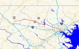
Maryland Route 26 is an east–west state highway
in the U.S. state
of Maryland
. Outside of the Baltimore city limits, it is known as Liberty Road; inside the city limits it is known as Liberty Heights Avenue.
The route is the only east–west thoroughfare in Eldersburg
; as a result, it is often congested during peak hours.
, which at that point is known as Swann Drive and runs along the perimeter of Druid Hill Park
. A block later, at Mondawmin Mall
and Metro Station, the road curves a little to the right, and then continues 3.6 miles (5.8 km) to Kelox Road, where it changes name to Liberty Road. Traffic is heaviest between Washington Avenue and Rolling Road during the day.
From here, in the Lochearn
area, the route becomes suburban in character, and continues 6.7 miles (10.8 km) through the Milford Mill
and Randallstown areas before narrowing down to two lanes.
After crossing the Liberty Reservoir
(about 11 miles (17.7 km) from the Baltimore City/County line), the road enters Carroll County
, widening again into a four-lane road through the Eldersburg
area, particularly as it passes the area's commercial development and the major intersection at Maryland Route 32
.
The road continues west until its end at an interchange with US 15
in Frederick
. The route is a major thoroughfare in Carroll and Frederick
and counties, serving many small towns between Baltimore and Frederick.
between Baltimore and Carroll Counties. The bridge is divided into two sections.
There is also a crossing of the Monocacy River
, which in a westbound direction, has an arch-bridge structure.
along MD 26.
There is no public transportation anywhere on Liberty Road west of the Chapman Road loop. Efforts to initiate such service in the past have failed, mostly due to community opposition.
and I-70
. At one time, MD 31
ran to Frederick and MD 26 began when MD 31 turned north to New Windsor
and Westminster
.
State highway
State highway, state road or state route can refer to one of three related concepts, two of them related to a state or provincial government in a country that is divided into states or provinces :#A...
in the U.S. state
U.S. state
A U.S. state is any one of the 50 federated states of the United States of America that share sovereignty with the federal government. Because of this shared sovereignty, an American is a citizen both of the federal entity and of his or her state of domicile. Four states use the official title of...
of Maryland
Maryland
Maryland is a U.S. state located in the Mid Atlantic region of the United States, bordering Virginia, West Virginia, and the District of Columbia to its south and west; Pennsylvania to its north; and Delaware to its east...
. Outside of the Baltimore city limits, it is known as Liberty Road; inside the city limits it is known as Liberty Heights Avenue.
The route is the only east–west thoroughfare in Eldersburg
Eldersburg, Maryland
Eldersburg is a census-designated place in Carroll County, Maryland, United States. The population was 27,741 at the 2000 census.-History:...
; as a result, it is often congested during peak hours.
Route description
From the east, MD 26 begins as Liberty Heights Avenue at MD 129Maryland Route 129
Maryland Route 129 is a state highway in the U.S. state of Maryland, running north-northwesterly from downtown Baltimore into Baltimore County, ending east of Reisterstown...
, which at that point is known as Swann Drive and runs along the perimeter of Druid Hill Park
Druid Hill Park
Druid Hill Park is a urban park in northwest Baltimore, Maryland. Its boundaries are marked by Druid Park Drive , Swann Drive and Reisterstown Road , and the Jones Falls Expressway...
. A block later, at Mondawmin Mall
Mondawmin Mall
Mondawmin Mall is a three-level shopping mall in Northwest Baltimore, Maryland, United States. The mall was a development of James Rouse and opened in October 1956....
and Metro Station, the road curves a little to the right, and then continues 3.6 miles (5.8 km) to Kelox Road, where it changes name to Liberty Road. Traffic is heaviest between Washington Avenue and Rolling Road during the day.
From here, in the Lochearn
Lochearn, Maryland
Lochearn is an unincorporated community and a census-designated place in Baltimore County, Maryland, immediately to the west of Baltimore. The population was 25,269 at the 2000 census.-Description:...
area, the route becomes suburban in character, and continues 6.7 miles (10.8 km) through the Milford Mill
Milford Mill, Maryland
Milford Mill is an unincorporated community and a census-designated place in Baltimore County, Maryland, United States. The population was 26,527 at the 2000 census.According to the United States Census Bureau, the CDP has a total area of , all of it land....
and Randallstown areas before narrowing down to two lanes.
After crossing the Liberty Reservoir
Liberty Reservoir
The Liberty Reservoir is a reservoir in the suburbs of Baltimore, Maryland. It is owned by the City of Baltimore Department of Public Works, but is located outside of the city, and it divides Baltimore and Carroll Counties.-History:...
(about 11 miles (17.7 km) from the Baltimore City/County line), the road enters Carroll County
Carroll County, Maryland
Carroll County is a county located in the U.S. state of Maryland. In 2010, its population was 167,134. It was named for Charles Carroll of Carrollton , signer of the American Declaration of Independence. Its county seat is Westminster....
, widening again into a four-lane road through the Eldersburg
Eldersburg, Maryland
Eldersburg is a census-designated place in Carroll County, Maryland, United States. The population was 27,741 at the 2000 census.-History:...
area, particularly as it passes the area's commercial development and the major intersection at Maryland Route 32
Maryland Route 32
Maryland Route 32 is a state highway in the U.S. state of Maryland. The state highway runs from Interstate 97 and MD 3 in Millersville west and north to Washington Road in Westminster. The east–west portion of MD 32 is the Patuxent Freeway, a four- to six-lane...
.
The road continues west until its end at an interchange with US 15
U.S. Route 15 in Maryland
U.S. Route 15 is a part of the U.S. Highway System that runs from Walterboro, South Carolina to Painted Post, New York. In Maryland, the highway runs from the Virginia state line at the Potomac River in Point of Rocks north to the Pennsylvania state line near Emmitsburg. US 15 is...
in Frederick
Frederick, Maryland
Frederick is a city in north-central Maryland. It is the county seat of Frederick County, the largest county by area in the state of Maryland. Frederick is an outlying community of the Washington-Arlington-Alexandria, DC-VA-MD-WV Metropolitan Statistical Area, which is part of a greater...
. The route is a major thoroughfare in Carroll and Frederick
Frederick County, Maryland
Frederick County is a county located in the western part of the U.S. state of Maryland, bordering the southern border of Pennsylvania and the northeastern border of Virginia. As of the 2010 Census, the population was 233,385....
and counties, serving many small towns between Baltimore and Frederick.
Major bridges
Route 26 has a long crossing of the Liberty ReservoirLiberty Reservoir
The Liberty Reservoir is a reservoir in the suburbs of Baltimore, Maryland. It is owned by the City of Baltimore Department of Public Works, but is located outside of the city, and it divides Baltimore and Carroll Counties.-History:...
between Baltimore and Carroll Counties. The bridge is divided into two sections.
There is also a crossing of the Monocacy River
Monocacy River
The Monocacy River is a free-flowing tributary of the Potomac River, which empties into the Atlantic Ocean via the Chesapeake Bay. The river is long, with a drainage area of about...
, which in a westbound direction, has an arch-bridge structure.
Public transportation
In Baltimore City and County, there are two main bus lines operated by the Maryland Transit AdministrationMaryland Transit Administration
The Maryland Transit Administration is a state-operated mass transit administration in Maryland, and is part of the Maryland Department of Transportation. It is better known as MTA Maryland to avoid confusion with other cities' transit agencies who share the initials MTA. The MTA operates a...
along MD 26.
- Route 52Route 52 (MTA Maryland)Route 52 is a bus route operated by the Maryland Transit Administration in Baltimore and its suburbs. The line currently runs from the Mondawmin Metro Subway Station along Liberty Heights Avenue and Liberty Road to a loop known as in Milford Mill with buses marked as "Milford Mill"...
operates from the beginning of Liberty Heights Avenue at the Mondawmin Metro Subway Station in Baltimore City to the intersection of Liberty and Rolling RoadRolling RoadRolling Road is a major cross county road that runs through Baltimore County, Maryland. The road, once a continuous route, is divided into two by Interstate 95...
s, then loops via Rolling, Church Lane, and Milford Mill Road. Service operates every 8–22 minutes, depending on the time of day. - Route 54Route 54 (MTA Maryland)Route 54 is a bus route that operates in Baltimore and its suburbs, serving the corridors of Park Heights Avenue, Milford Mill Road, and Liberty Road. All trips operate from the Penn-North Metro Subway Station in Baltimore City to the Milford Mill Metro Subway Station in Pikesville. From there,...
provides service from Milford Mill Road to a loop near Chapman Road (across from Liberty Ford) in Randallstown, and connects to the Metro Subway along Milford Mill Road. Service is provided every 20–30 minutes at most times, depending on the time of day. - Route 77Route 77 (MTA Maryland)Route 77 is a bus route operated by the Maryland Transit Administration in the suburbs of Baltimore. The line currently runs from the Old Court Metro Subway Station in Pikesville, Maryland to the Patapsco Light Rail Stop, and serves Randallstown, Windsor Mill, Woodlawn, Catonsville, Arbutus,...
also overlaps with Route 54 line between Milford Mill and Old Court RoadOld Court RoadOld Court Road is a major cross-county road in the central region of the U.S. state of Maryland, running east–west for approximately through Baltimore County, Maryland from just inside Howard County, Maryland at Woodstock on the Patapsco River to Maryland Route 25 near Towson...
s. In addition, several other bus lines operate on various streets intersecting with Liberty Road inside of Baltimore City line. These include routes 51Route 51 (MTA Maryland)Route 51 is a bus route operated by the Maryland Transit Administration in Baltimore and its suburbs. The line currently runs from the Rogers Avenue Metro Subway Station to the Patapsco Light Rail Stop, serving the communities of Arlington, Ashburton, Mondawmin, Rosemont, Baltimore, Cherry Hill,...
on Hilton Street, 91 on Garrison Boulevard, 57 on Gwynn Oak Avenue, and 44Route 44 (MTA Maryland)Route 44 is a bus route operated by the Maryland Transit Administration in Baltimore and its suburbs. The line currently runs from Rosedale Industrial Park near Pulaski Highway just outside the Baltimore city limits on the east side of the city across the northern portion of the city to Security...
on Rogers Avenue. - TransITTransit-Transportation:* Ford Transit, a van made by the Ford Motor Company* Mass transit, public transport systems in which passengers are carried in large numbers* Navigational transit, when a navigator observes two fixed reference points in line...
(Frederick County's transit service) provides service on Route 85 to the Wal-Mart at the end of MD-26 in Frederick.
There is no public transportation anywhere on Liberty Road west of the Chapman Road loop. Efforts to initiate such service in the past have failed, mostly due to community opposition.
History
Maryland Route 26 served as a primary route connecting Baltimore to Frederick prior to the arrival of US 40U.S. Route 40 in Maryland
U.S. Route 40 in the U.S. state of Maryland runs from western Maryland to Cecil County in the state's northeastern corner. With a total length of over , it is the longest numbered highway in Maryland. Almost half of the road overlaps with Interstate 68 or Interstate 70, while the old alignment...
and I-70
Interstate 70 in Maryland
Interstate 70 is a part of the Interstate Highway System that runs from Cove Fort, Utah to Baltimore, Maryland. In Maryland, the Interstate Highway runs from the Pennsylvania state line in Hancock east to the Interstate's eastern terminus near its junction with I-695 at a park and ride in...
. At one time, MD 31
Maryland Route 31
Maryland Route 31 is a state highway in the U.S. state of Maryland. Known for most of its length as New Windsor Road, the state highway runs from MD 26 in Libertytown east to MD 140 in Westminster. MD 31 connects the county seats of Frederick and Westminster via Libertytown in eastern Frederick...
ran to Frederick and MD 26 began when MD 31 turned north to New Windsor
New Windsor, Maryland
New Windsor is a town in Carroll County, Maryland, United States. The population was 1,303 at the 2000 census. It is a suburb of Westminster, which is about 6 miles east of New Windsor on Maryland Route 31. It contains many neighborhoods, the most known being the 100-acre Atlee Ridge, or "The...
and Westminster
Westminster, Maryland
Westminster is a city in northern Maryland, United States. It is the seat of Carroll County. The city's population was 18,590 at the 2010 census. Westminster is an outlying community within the Baltimore-Towson, MD MSA, which is part of a greater Washington-Baltimore-Northern Virginia, DC-MD-VA-WV...
.
Junction list
| County | Location | Mile |
Road | Notes |
|---|---|---|---|---|
| Frederick Frederick County, Maryland Frederick County is a county located in the western part of the U.S. state of Maryland, bordering the southern border of Pennsylvania and the northeastern border of Virginia. As of the 2010 Census, the population was 233,385.... |
Frederick Frederick, Maryland Frederick is a city in north-central Maryland. It is the county seat of Frederick County, the largest county by area in the state of Maryland. Frederick is an outlying community of the Washington-Arlington-Alexandria, DC-VA-MD-WV Metropolitan Statistical Area, which is part of a greater... |
0.00 | Western terminus, interchange | |
| 0.54 | Wormans Mill Road | Former MD 355 Maryland Route 355 Maryland Route 355 is a north–south road in western central Maryland in the United States. The southern terminus of the route is at the Washington, D.C. border in Friendship Heights, Montgomery County, where it continues south as Wisconsin Avenue into Washington. The northern terminus is... |
||
| 2.20 | Southern terminus of MD 194 | |||
| Libertytown Libertytown, Maryland Libertytown is an unincorporated community in Frederick County, Maryland, United States. The Abraham Jones House was listed on the National Register of Historic Places in 1973.-References:... |
9.35 | Southern terminus of MD 550 | ||
| 9.69 | ||||
| 10.11 | ||||
| Carroll Carroll County, Maryland Carroll County is a county located in the U.S. state of Maryland. In 2010, its population was 167,134. It was named for Charles Carroll of Carrollton , signer of the American Declaration of Independence. Its county seat is Westminster.... |
Taylorsville | 18.32 | ||
| Freedom | 23.04 | Interchange | ||
| Eldersburg Eldersburg, Maryland Eldersburg is a census-designated place in Carroll County, Maryland, United States. The population was 27,741 at the 2000 census.-History:... |
26.62 | |||
| Baltimore Baltimore County, Maryland Baltimore County is a county located in the northern part of the US state of Maryland. In 2010, its population was 805,029. It is part of the Baltimore-Washington Metropolitan Area. Its county seat is Towson. The name of the county was derived from the barony of the Proprietor of the Maryland... |
Randallstown Randallstown, Maryland Randallstown is an unincorporated community and a census-designated place in Baltimore County, Maryland, United States. It is named after Christopher and Thomas Randall, two 18th-century tavern-keepers. At that time, Randallstown was a tollgate crossroads on the Liberty Turnpike, a major east-west... |
36.67 | Old Court Road Old Court Road Old Court Road is a major cross-county road in the central region of the U.S. state of Maryland, running east–west for approximately through Baltimore County, Maryland from just inside Howard County, Maryland at Woodstock on the Patapsco River to Maryland Route 25 near Towson... |
|
| Milford | 38.64 | Interchange | ||
| Baltimore City | 44.10 | Eastern terminus | ||
External links
- MD 26 @ MDRoads.com
- Key points on MD-26 on Google Street ViewGoogle Street ViewGoogle Street View is a technology featured in Google Maps and Google Earth that provides panoramic views from various positions along many streets in the world...