
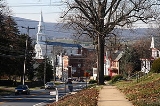
Middletown, Maryland
Encyclopedia
Middletown is a town in Frederick County
, Maryland
, United States
. The population was 2,668 at the 2000 census. Middletown is a small, rural community steeped in American history. Located in the beautiful Middletown Valley that stretches between the Catoctin Mountains on the east and South Mountain on the west, the town reportedly gained its name from its location midway between those ranges.
, while surveying the South Mountain area, reported that the valley to the east was one of the most beautiful places he had ever seen. Later, as a Colonel in 1755, he was to accompany General Braddock on the old Indian Trail that ran through the valley on his way to Fort Cumberland.
The early German and English settlers started to arrive in the valley in the 1730s. Among them was Michael Jesserong, who paid £66 for 50 acres (202,343 m²). He named his property Middletown and sold the first lots there in 1767, the date officially marked as that of the town’s founding.
The history of Middletown is a mirror on the nation’s development. Main Street spread to the west with construction of the National Pike through the town in 1806; the telegraph lines from Frederick to Hagerstown were routed through Middletown in 1854; and in 1896, car 11 of the Frederick Middletown Railway made its first run to Middletown. During the Civil War, both armies passed through the town to the battles of South Mountain and Antietam. In the aftermath of those battles, Middletown opened its churches and homes to care for the wounded.
According to the United States Census Bureau
, the town has a total area of 1.7 square miles (4.4 km²), all of it land. Catoctin Creek (Maryland)
flows due south from about one mile west of town to several miles south of town.
of 2000, there were 2,668 people, 960 households, and 728 families residing in the town. The population density
was 1,577.3 people per square mile (609.5/km²). There were 981 housing units at an average density of 580.0 per square mile (224.1/km²). The racial makeup of the town was 96.89% White, 1.46% African American, 0.07% Native American, 0.34% Asian, 0.22% from other races
, and 1.01% from two or more races. Hispanic or Latino of any race were 0.82% of the population.
There were 960 households out of which 44.6% had children under the age of 18 living with them, 63.6% were married couples
living together, 8.6% had a female householder with no husband present, and 24.1% were non-families. 18.9% of all households were made up of individuals and 8.9% had someone living alone who was 65 years of age or older. The average household size was 2.78 and the average family size was 3.21.
In the town the population was spread out with 32.0% under the age of 18, 5.4% from 18 to 24, 29.9% from 25 to 44, 21.7% from 45 to 64, and 11.0% who were 65 years of age or older. The median age was 36 years. For every 100 females there were 91.8 males. For every 100 females age 18 and over, there were 87.6 males.
The median income for a household in the town was $67,266, and the median income for a family was $80,115. Males had a median income of $48,864 versus $31,602 for females. The per capita income
for the town was $25,759. About 1.8% of families and 3.0% of the population were below the poverty line, including 2.1% of those under age 18 and 8.5% of those age 65 or over.
Frederick County, Maryland
Frederick County is a county located in the western part of the U.S. state of Maryland, bordering the southern border of Pennsylvania and the northeastern border of Virginia. As of the 2010 Census, the population was 233,385....
, Maryland
Maryland
Maryland is a U.S. state located in the Mid Atlantic region of the United States, bordering Virginia, West Virginia, and the District of Columbia to its south and west; Pennsylvania to its north; and Delaware to its east...
, United States
United States
The United States of America is a federal constitutional republic comprising fifty states and a federal district...
. The population was 2,668 at the 2000 census. Middletown is a small, rural community steeped in American history. Located in the beautiful Middletown Valley that stretches between the Catoctin Mountains on the east and South Mountain on the west, the town reportedly gained its name from its location midway between those ranges.
History
A young Lieutenant George WashingtonGeorge Washington
George Washington was the dominant military and political leader of the new United States of America from 1775 to 1799. He led the American victory over Great Britain in the American Revolutionary War as commander-in-chief of the Continental Army from 1775 to 1783, and presided over the writing of...
, while surveying the South Mountain area, reported that the valley to the east was one of the most beautiful places he had ever seen. Later, as a Colonel in 1755, he was to accompany General Braddock on the old Indian Trail that ran through the valley on his way to Fort Cumberland.
The early German and English settlers started to arrive in the valley in the 1730s. Among them was Michael Jesserong, who paid £66 for 50 acres (202,343 m²). He named his property Middletown and sold the first lots there in 1767, the date officially marked as that of the town’s founding.
The history of Middletown is a mirror on the nation’s development. Main Street spread to the west with construction of the National Pike through the town in 1806; the telegraph lines from Frederick to Hagerstown were routed through Middletown in 1854; and in 1896, car 11 of the Frederick Middletown Railway made its first run to Middletown. During the Civil War, both armies passed through the town to the battles of South Mountain and Antietam. In the aftermath of those battles, Middletown opened its churches and homes to care for the wounded.
Geography
Middletown is located at 39°26′28"N 77°32′38"W (39.441155, -77.543761).According to the United States Census Bureau
United States Census Bureau
The United States Census Bureau is the government agency that is responsible for the United States Census. It also gathers other national demographic and economic data...
, the town has a total area of 1.7 square miles (4.4 km²), all of it land. Catoctin Creek (Maryland)
Catoctin Creek (Maryland)
Catoctin Creek is a tributary of the Potomac River in Frederick County, Maryland, USA. Its source is formed in the Myersville, MD area and flows directly south for the entire length of the stream. Catoctin Creek enters the Potomac River east of Brunswick. The stream flows through Catoctin Creek...
flows due south from about one mile west of town to several miles south of town.
Demographics
As of the censusCensus
A census is the procedure of systematically acquiring and recording information about the members of a given population. It is a regularly occurring and official count of a particular population. The term is used mostly in connection with national population and housing censuses; other common...
of 2000, there were 2,668 people, 960 households, and 728 families residing in the town. The population density
Population density
Population density is a measurement of population per unit area or unit volume. It is frequently applied to living organisms, and particularly to humans...
was 1,577.3 people per square mile (609.5/km²). There were 981 housing units at an average density of 580.0 per square mile (224.1/km²). The racial makeup of the town was 96.89% White, 1.46% African American, 0.07% Native American, 0.34% Asian, 0.22% from other races
Race (United States Census)
Race and ethnicity in the United States Census, as defined by the Federal Office of Management and Budget and the United States Census Bureau, are self-identification data items in which residents choose the race or races with which they most closely identify, and indicate whether or not they are...
, and 1.01% from two or more races. Hispanic or Latino of any race were 0.82% of the population.
There were 960 households out of which 44.6% had children under the age of 18 living with them, 63.6% were married couples
Marriage
Marriage is a social union or legal contract between people that creates kinship. It is an institution in which interpersonal relationships, usually intimate and sexual, are acknowledged in a variety of ways, depending on the culture or subculture in which it is found...
living together, 8.6% had a female householder with no husband present, and 24.1% were non-families. 18.9% of all households were made up of individuals and 8.9% had someone living alone who was 65 years of age or older. The average household size was 2.78 and the average family size was 3.21.
In the town the population was spread out with 32.0% under the age of 18, 5.4% from 18 to 24, 29.9% from 25 to 44, 21.7% from 45 to 64, and 11.0% who were 65 years of age or older. The median age was 36 years. For every 100 females there were 91.8 males. For every 100 females age 18 and over, there were 87.6 males.
The median income for a household in the town was $67,266, and the median income for a family was $80,115. Males had a median income of $48,864 versus $31,602 for females. The per capita income
Per capita income
Per capita income or income per person is a measure of mean income within an economic aggregate, such as a country or city. It is calculated by taking a measure of all sources of income in the aggregate and dividing it by the total population...
for the town was $25,759. About 1.8% of families and 3.0% of the population were below the poverty line, including 2.1% of those under age 18 and 8.5% of those age 65 or over.