
Maryland Route 550
Encyclopedia
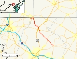
Maryland Route 550 is a state highway
in the U.S. state of Maryland
. The state highway runs 24.43 miles (39.3 km) from MD 26
in Libertytown
north to Pen Mar Road in Fort Ritchie
. MD 550 runs southeast–northwest across central Frederick County
, connecting Fort Ritchie in the northeastern corner of Washington County
and Libertytown with the towns of Thurmont
and Woodsboro
and the smaller communities of Creagerstown
and Sabillasville
. South of the highway's junction with U.S. Route 15
(US 15) in Thurmont, the state highway passes through the wide valley of the Monocacy River
; to the north, the highway passes along the northern edge of Catoctin Mountain
and crests South Mountain
near Blue Ridge Summit, Pennsylvania
.
MD 550 was built in two main sections. The highway from Thurmont to Blue Ridge Summit was constructed in the mid 1920s as MD 81. MD 81 was extended west to Fort Ritchie in the mid 1930s. MD 550 was constructed from Libertytown to Woodsboro in the mid to late 1930s. A second disjoint section of the state highway was built from Creagerstown to Thurmont in the late 1930s. The two segments of MD 550 were united when the designation was assigned to the highway between Woodsboro and Creagerstown in the mid 1950s. MD 550 was extended northwest from Thurmont to Fort Ritchie, assuming all of MD 81, in the late 1970s.
(Woodsboro Pike) on the east side of the town; Woodsboro Road continues straight toward the center of town while MD 550 runs concurrently
northward with MD 194 on the east side of town. MD 550 turns west onto Woodsboro Creagerstown Road, which immediately intersects the north end of Main Street, which is unsigned MD 194A. The state highway intersects the Woodsboro–Taneytown branch of the Maryland Midland Railway
and receives the northern end of Creagerstown Road, the old alignment of MD 550, before heading northwest past a quarry shielded from the road by an earthen berm on the northbound side of the highway.
MD 550 continues northwest through farmland and crosses the Monocacy River on its way to Creagerstown. The state highway passes the historic farmhouses Pennterra
and Strawberry Hill
before oassing through the village, which contains the St. John's Church at Creagerstown Historic District
. MD 550 continues northwest as Creagerstown Road to the hamlet of Jimtown; the highway intersects Moser Road and Hessong Bridge at a four-way stop and turns north onto Jimtown Road. The state highway enters the town of Thurmont just before the highway intersects MD 77
(Rocky Ridge Road). The two state highways run concurrently northwest toward downtown Thurmont as Main Street. In the center of town, MD 550 turns north onto Church Street, which passes under the main line of the Maryland Midland Railway. The state highway intersects MD 806
(Emmitsburg Road), the old alignment of US 15, before meeting US 15 (Catoctin Mountain Highway) at a diamond interchange
.
MD 550 heads northwest out of the town of Thurmont and passes Catoctin High School
as Sabillasville Road. The state highway follows the northern boundary of Catoctin Mountain Park
as it starts to wind its way through the narrow valley of Owens Creek between Piney Mountain to the north and Catoctin Mountain to the south, passing under the parallel Maryland Midland Railway line multiple times. MD 550 leaves Owens Creek in the hamlet of Lantz and passes through the Harbaugh Valley, where the highway crosses Middle Creek, crosses under the railroad, and passes through the village of Sabillasville. The state highway crosses over Friends Creek then leaves the valley and ascends the eastern flank of South Mountain. MD 550 passes the Victor Cullen School Power House
and the road to the preserved Victor Cullen Center
before curving to the west at the top of the mountain, passing within 500 feet (152.4 m) of the Pennsylvania
state line as the highway enters Washington County just south of Blue Ridge Summit.
MD 550 curves to the southwest as Military Road and passes through the communities of Highfield and Cascade
. The state highway intersects MD 491
(Macfee Hill Road) in Fort Ritchie, which contains the former Army base of the same name
that is presently being redeveloped. MD 550 turns north onto Macfee Hill Road and crosses CSX
's Hanover Subdivision
at grade. At the intersection with the Camp Ritchie Access Road and Pennersville Road, the state highway turns west onto Pen Mar Road. MD 550 passes under the railroad and reaches its northern terminus just west of Lake Royer. The highway continues northwest as county-maintained Pen Mar Road, which passes through the community of Pen Mar, home of Pen Mar Park
, a former mountain resort.
east and north through Creagerstown to near Loys Station south of MD 77. The portion of MD 72 through Creagerstown was built in 1926. The first section of MD 550 proper was 1 miles (1.6 km) of concrete road built east from Woodsboro in 1933. MD 550 was extended east to Cabbage Run between 1933 and 1935. A second section of MD 550 was started from MD 77 east of Thurmont towards Creagerstown in 1938. This western section was completed in 1939, the same year the eastern section was completed between Woodsboro and Libertytown.
The first section of what would become MD 81 was paved as a state-aid road from the Pennsylvania state line south along Warren Avenue and Cascade Road through Highfield and Cascade by 1910. The main portion of MD 81 was constructed from Emmitsburg Road (which later became US 15 and is now MD 806) north to Sabillasville around 1923. The highway was completed to the Pennsylvania state line at Blue Ridge Summit, using what are now Naylor Road and Old Sabillasville Road, around 1927. The pre-1910 portion of MD 81 in Washington County was reconstructed and extended west toward Pen Mar in 1930. Military Road was constructed around 1933 between Highfield and Fort Ritchie. The eastern end of Military Road at the Frederick–Washington county line was tied into a relocation of MD 81 between Sabillasville and Blue Ridge Summit that was completed in 1936. This bypass included an underpass of the Western Maryland Railway at Sabillasville and resulted in the highway no longer entering Pennsylvania; the old alignment of MD 81 was designated MD 625.
In 1956, MD 72 was removed from the state highway system. MD 550 was extended southeast through Creagerstown to Woodsboro to connect with the Woodsboro–Libertytown section. MD 550 was extended through Thurmont, west along MD 77 and north along MD 806, and assumed all of MD 81 in 1977. Construction on MD 194's bypass of Woodsboro was started in 1995. When the bypass was completed in 1997, MD 550 was removed from the center of Woodsboro to its present alignment on the northern and eastern sides of town.
!County
!Location
!Mile
!Destinations
!Notes
|-
|rowspan=9|Frederick
|Libertytown
|0.00
|
|Southern terminus
|-
|rowspan=3|Woodsboro
|5.01
|
|South end of concurrency with MD 194
|-
|5.56
|
|North end of concurrency with MD 194
|-
|5.61
|Main Street south
|MD 550 turns northwest at this intersection; Main Street is unsigned MD 194A
|-
|rowspan=5|Thurmont
|11.67
|Hessong Bridge Road south / Moser Road west
|MD 550 turns north onto Jimtown Road
|-
|12.92
|
|South end of concurrency with MD 77
|-
|13.91
|
|MD 550 turns north onto Church Street; north end of concurrency with MD 77
|-
|14.27
|
|Officially MD 806R
|-
|14.71
|
|Diamond interchange
|-
|rowspan=3|Washington
|rowspan=3|Fort Ritchie
|23.84
|
|MD 550 turns north onto Macfee Hill Road
|-
|24.23
|Camp Ritchie Access Road north / Pennersville Road east
|MD 550 turns west onto Pen Mar Road
|-
|24.43
|Pen Mar Road north – Pen Mar
|Northern terminus
State highway
State highway, state road or state route can refer to one of three related concepts, two of them related to a state or provincial government in a country that is divided into states or provinces :#A...
in the U.S. state of Maryland
Maryland
Maryland is a U.S. state located in the Mid Atlantic region of the United States, bordering Virginia, West Virginia, and the District of Columbia to its south and west; Pennsylvania to its north; and Delaware to its east...
. The state highway runs 24.43 miles (39.3 km) from MD 26
Maryland Route 26
Maryland Route 26 is an east–west state highway in the U.S. state of Maryland. Outside of the Baltimore city limits, it is known as Liberty Road; inside the city limits it is known as Liberty Heights Avenue....
in Libertytown
Libertytown, Maryland
Libertytown is an unincorporated community in Frederick County, Maryland, United States. The Abraham Jones House was listed on the National Register of Historic Places in 1973.-References:...
north to Pen Mar Road in Fort Ritchie
Fort Ritchie, Maryland
Fort Ritchie is a census-designated place in Washington County, Maryland, United States, just south of the Pennsylvania state line. The population was 276 at the 2000 census. Fort Ritchie is a former U.S. military base that closed in September 1998 pursuant to the 1995 Base Realignment and...
. MD 550 runs southeast–northwest across central Frederick County
Frederick County, Maryland
Frederick County is a county located in the western part of the U.S. state of Maryland, bordering the southern border of Pennsylvania and the northeastern border of Virginia. As of the 2010 Census, the population was 233,385....
, connecting Fort Ritchie in the northeastern corner of Washington County
Washington County, Maryland
Washington County is a county located in the western part of the U.S. state of Maryland, bordering southern Pennsylvania to the north, northern Virginia to the south, and the Eastern Panhandle of West Virginia to the south and west. As of the 2010 Census, its population is 147,430...
and Libertytown with the towns of Thurmont
Thurmont, Maryland
Thurmont is a town in Frederick County, Maryland, United States. The population was 5,588 at the 2000 census. The town is located in the northern part of Frederick County , approximately ten miles from the Pennsylvania border, along U.S. Highway 15...
and Woodsboro
Woodsboro, Maryland
Woodsboro is a town in Frederick County, Maryland, United States that was granted to Joseph Wood in 1693. The population was 846 at the 2000 census.-History:...
and the smaller communities of Creagerstown
Creagerstown, Maryland
Creagerstown is an unincorporated community in Frederick County, Maryland, United States.The Georgian-style farmhouse Strawberry Hill is located close to Creagerstown, being located on Creagerstown Road and in Frederick County's Creagerstown Election District. It was listed on the National Register...
and Sabillasville
Sabillasville, Maryland
Sabillasville is an unincorporated community in Frederick County, Maryland, United States. Victor Cullen School Power House was listed on the National Register of Historic Places in 1987 and the Victor Cullen Center, Old Administration Building was listed in 1990.-References:...
. South of the highway's junction with U.S. Route 15
U.S. Route 15 in Maryland
U.S. Route 15 is a part of the U.S. Highway System that runs from Walterboro, South Carolina to Painted Post, New York. In Maryland, the highway runs from the Virginia state line at the Potomac River in Point of Rocks north to the Pennsylvania state line near Emmitsburg. US 15 is...
(US 15) in Thurmont, the state highway passes through the wide valley of the Monocacy River
Monocacy River
The Monocacy River is a free-flowing tributary of the Potomac River, which empties into the Atlantic Ocean via the Chesapeake Bay. The river is long, with a drainage area of about...
; to the north, the highway passes along the northern edge of Catoctin Mountain
Catoctin Mountain
Catoctin Mountain, along with the geologically associated Bull Run Mountains, comprises the easternmost mountain ridge of the Blue Ridge Mountains, which are in turn a part of the Appalachian Mountains range...
and crests South Mountain
South Mountain (Maryland and Pennsylvania)
South Mountain is the northern extension of the Blue Ridge Mountain range in Maryland and Pennsylvania. From the Potomac River near Knoxville, Maryland in the south, to Dillsburg, Pennsylvania in the north, the long range separates the Hagerstown and Cumberland valleys from the Piedmont regions of...
near Blue Ridge Summit, Pennsylvania
Blue Ridge Summit, Pennsylvania
Blue Ridge Summit is an unincorporated community in Franklin County, Pennsylvania, United States, southwest of Gettysburg in the central part of the state, adjoining Pennsylvania's southern border with Maryland. It is less than 3 miles east of Pen Mar, Maryland...
.
MD 550 was built in two main sections. The highway from Thurmont to Blue Ridge Summit was constructed in the mid 1920s as MD 81. MD 81 was extended west to Fort Ritchie in the mid 1930s. MD 550 was constructed from Libertytown to Woodsboro in the mid to late 1930s. A second disjoint section of the state highway was built from Creagerstown to Thurmont in the late 1930s. The two segments of MD 550 were united when the designation was assigned to the highway between Woodsboro and Creagerstown in the mid 1950s. MD 550 was extended northwest from Thurmont to Fort Ritchie, assuming all of MD 81, in the late 1970s.
Route description
MD 550 begins at an intersection with MD 26 (Liberty Road) in Libertytown. The state highway heads northwest as two-lane Woodsboro Road through farmland. MD 550 crosses Cabbage Run, passes through a gap in Laurel Hill, and crosses Israel Creek before reaching Woodsboro. MD 550 intersects MD 194Maryland Route 194
Maryland Route 194 is a state highway in the U.S. state of Maryland. The state highway runs from MD 26 in Ceresville north to the Pennsylvania state line near Taneytown, where the highway continues as Pennsylvania Route 194 toward Hanover...
(Woodsboro Pike) on the east side of the town; Woodsboro Road continues straight toward the center of town while MD 550 runs concurrently
Concurrency (road)
A concurrency, overlap, or coincidence in a road network is an instance of one physical road bearing two or more different highway, motorway, or other route numbers...
northward with MD 194 on the east side of town. MD 550 turns west onto Woodsboro Creagerstown Road, which immediately intersects the north end of Main Street, which is unsigned MD 194A. The state highway intersects the Woodsboro–Taneytown branch of the Maryland Midland Railway
Maryland Midland Railway
The Maryland Midland Railway is a Class III short-line railroad operating about 63 miles of track in central Maryland. It was originally headquartered in the former Western Maryland Railway station in Union Bridge, Maryland, however it is now located in a new facility across the street from the...
and receives the northern end of Creagerstown Road, the old alignment of MD 550, before heading northwest past a quarry shielded from the road by an earthen berm on the northbound side of the highway.
MD 550 continues northwest through farmland and crosses the Monocacy River on its way to Creagerstown. The state highway passes the historic farmhouses Pennterra
Pennterra (Creagerstown, Maryland)
Pennterra is a Georgian farmhouse near Thurmont, Maryland. The house is notable for its locally-quarried stonework and its unusually fine proportions. The house was built at about the same time as nearby Strawberry Hill, which was built in 1783....
and Strawberry Hill
Strawberry Hill (Creagerstown, Maryland)
Strawberry Hill is a Georgian style farmhouse near Thurmont, Maryland, built in 1783. The house is substantially similar in plan to nearby Pennterra, but lacks Pennterra's later Victorian additions. The locally-quarried stone includes an unusual diamond pattern on the southeast side of the...
before oassing through the village, which contains the St. John's Church at Creagerstown Historic District
St. John's Church at Creagerstown Historic District
The St. John's Church at Creagerstown Historic District includes several historic churches and public buildings in a small area, including:*Creagerstown School Number 2, now the parish house for St. John's Church...
. MD 550 continues northwest as Creagerstown Road to the hamlet of Jimtown; the highway intersects Moser Road and Hessong Bridge at a four-way stop and turns north onto Jimtown Road. The state highway enters the town of Thurmont just before the highway intersects MD 77
Maryland Route 77
Maryland Route 77 is a state highway in the U.S. state of Maryland. The state highway runs from MD 64 in Smithsburg east to MD 194 in Keymar. MD 77 is the main east–west highway of northern Frederick County...
(Rocky Ridge Road). The two state highways run concurrently northwest toward downtown Thurmont as Main Street. In the center of town, MD 550 turns north onto Church Street, which passes under the main line of the Maryland Midland Railway. The state highway intersects MD 806
Maryland Route 806
Maryland Route 806 is a state highway in the U.S. state of Maryland. The state highway runs a total of in two segments from U.S. Route 15 near Catoctin Furnace north to Roddy Creek Road near Thurmont...
(Emmitsburg Road), the old alignment of US 15, before meeting US 15 (Catoctin Mountain Highway) at a diamond interchange
Diamond interchange
A diamond interchange is a common type of road junction, used where a freeway crosses a minor road. The freeway itself is grade-separated from the minor road, one crossing the other over a bridge...
.
MD 550 heads northwest out of the town of Thurmont and passes Catoctin High School
Catoctin High School
Catoctin High School is a four-year public high school in Thurmont, Frederick County, Maryland, United States....
as Sabillasville Road. The state highway follows the northern boundary of Catoctin Mountain Park
Catoctin Mountain Park
Catoctin Mountain Park, located in north-central Maryland, is part of the forested Catoctin Mountain ridge that forms the eastern rampart of the Appalachian Mountains...
as it starts to wind its way through the narrow valley of Owens Creek between Piney Mountain to the north and Catoctin Mountain to the south, passing under the parallel Maryland Midland Railway line multiple times. MD 550 leaves Owens Creek in the hamlet of Lantz and passes through the Harbaugh Valley, where the highway crosses Middle Creek, crosses under the railroad, and passes through the village of Sabillasville. The state highway crosses over Friends Creek then leaves the valley and ascends the eastern flank of South Mountain. MD 550 passes the Victor Cullen School Power House
Victor Cullen School Power House
The Victor Cullen School Power House is a historic power house building located at Sabillasville, Frederick County, Maryland. It is a -story, Renaissance Revival stone structure, with a hip roof and a fully exposed basement...
and the road to the preserved Victor Cullen Center
Victor Cullen Center, Old Administration Building
The Victor Cullen Center, Old Administration Building is a historic building located at Sabillasville, Frederick County, Maryland, United States. It is a -story, stone and frame structure located on a hillside with four stone chimneys, two on each gable end...
before curving to the west at the top of the mountain, passing within 500 feet (152.4 m) of the Pennsylvania
Pennsylvania
The Commonwealth of Pennsylvania is a U.S. state that is located in the Northeastern and Mid-Atlantic regions of the United States. The state borders Delaware and Maryland to the south, West Virginia to the southwest, Ohio to the west, New York and Ontario, Canada, to the north, and New Jersey to...
state line as the highway enters Washington County just south of Blue Ridge Summit.
MD 550 curves to the southwest as Military Road and passes through the communities of Highfield and Cascade
Highfield-Cascade, Maryland
Highfield-Cascade is a census-designated place in Washington County, Maryland, United States. The population was 1,141 at the 2000 census.-Geography:Highfield-Cascade is located at ....
. The state highway intersects MD 491
Maryland Route 491
Maryland Route 491 is a state highway in the U.S. state of Maryland. Known for most of its length as Raven Rock Road, the state highway runs from MD 64 in Smithsburg north to MD 550 in Fort Ritchie. The middle portion of MD 491 was constructed in the mid 1950s...
(Macfee Hill Road) in Fort Ritchie, which contains the former Army base of the same name
Fort Ritchie
Fort Ritchie was a military installation south of Blue Ridge Summit, Pennsylvania in the area of South Mountain . The installations's closure under the 1995 Base Realignment and Closure was nearly complete by 1998: "Out the Gate, by 98" .-History:In 1815, the Buena Vista Ice Company constructed two...
that is presently being redeveloped. MD 550 turns north onto Macfee Hill Road and crosses CSX
CSX Transportation
CSX Transportation operates a Class I railroad in the United States known as the CSX Railroad. It is the main subsidiary of the CSX Corporation. The company is headquartered in Jacksonville, Florida, and owns approximately 21,000 route miles...
's Hanover Subdivision
Hanover Subdivision
The Hanover Subdivision is a railroad line owned and operated by CSX Transportation in the U.S. states of Maryland and Pennsylvania. The line runs from Baltimore, Maryland west to Hagerstown, Maryland along several former Western Maryland Railway lines...
at grade. At the intersection with the Camp Ritchie Access Road and Pennersville Road, the state highway turns west onto Pen Mar Road. MD 550 passes under the railroad and reaches its northern terminus just west of Lake Royer. The highway continues northwest as county-maintained Pen Mar Road, which passes through the community of Pen Mar, home of Pen Mar Park
Pen Mar Park
Pen Mar Park is a scenic area located on High Rock Road on the Mason-Dixon line in Washington County, Maryland. In 1877, the site was opened as an amusement park by the Western Maryland Railroad...
, a former mountain resort.
History
MD 550 was constructed in two main sections: MD 550 between Libertytown and Thurmont, and MD 81 from Thurmont to Fort Ritchie. The first section of the Libertytown–Thurmont portion of MD 550 was constructed as a segment of former MD 72. MD 72 followed Lewistown Road and Old Frederick Road from US 15 at LewistownLewistown, Frederick County, Maryland
Lewistown is an unincorporated community in Frederick County, Maryland, United States.-References:...
east and north through Creagerstown to near Loys Station south of MD 77. The portion of MD 72 through Creagerstown was built in 1926. The first section of MD 550 proper was 1 miles (1.6 km) of concrete road built east from Woodsboro in 1933. MD 550 was extended east to Cabbage Run between 1933 and 1935. A second section of MD 550 was started from MD 77 east of Thurmont towards Creagerstown in 1938. This western section was completed in 1939, the same year the eastern section was completed between Woodsboro and Libertytown.
The first section of what would become MD 81 was paved as a state-aid road from the Pennsylvania state line south along Warren Avenue and Cascade Road through Highfield and Cascade by 1910. The main portion of MD 81 was constructed from Emmitsburg Road (which later became US 15 and is now MD 806) north to Sabillasville around 1923. The highway was completed to the Pennsylvania state line at Blue Ridge Summit, using what are now Naylor Road and Old Sabillasville Road, around 1927. The pre-1910 portion of MD 81 in Washington County was reconstructed and extended west toward Pen Mar in 1930. Military Road was constructed around 1933 between Highfield and Fort Ritchie. The eastern end of Military Road at the Frederick–Washington county line was tied into a relocation of MD 81 between Sabillasville and Blue Ridge Summit that was completed in 1936. This bypass included an underpass of the Western Maryland Railway at Sabillasville and resulted in the highway no longer entering Pennsylvania; the old alignment of MD 81 was designated MD 625.
In 1956, MD 72 was removed from the state highway system. MD 550 was extended southeast through Creagerstown to Woodsboro to connect with the Woodsboro–Libertytown section. MD 550 was extended through Thurmont, west along MD 77 and north along MD 806, and assumed all of MD 81 in 1977. Construction on MD 194's bypass of Woodsboro was started in 1995. When the bypass was completed in 1997, MD 550 was removed from the center of Woodsboro to its present alignment on the northern and eastern sides of town.
Junction list
{| class=wikitable!County
!Location
!Mile
!Destinations
!Notes
|-
|rowspan=9|Frederick
Frederick County, Maryland
Frederick County is a county located in the western part of the U.S. state of Maryland, bordering the southern border of Pennsylvania and the northeastern border of Virginia. As of the 2010 Census, the population was 233,385....
|Libertytown
Libertytown, Maryland
Libertytown is an unincorporated community in Frederick County, Maryland, United States. The Abraham Jones House was listed on the National Register of Historic Places in 1973.-References:...
|0.00
|
|Southern terminus
|-
|rowspan=3|Woodsboro
Woodsboro, Maryland
Woodsboro is a town in Frederick County, Maryland, United States that was granted to Joseph Wood in 1693. The population was 846 at the 2000 census.-History:...
|5.01
|
|South end of concurrency with MD 194
|-
|5.56
|
|North end of concurrency with MD 194
|-
|5.61
|Main Street south
|MD 550 turns northwest at this intersection; Main Street is unsigned MD 194A
|-
|rowspan=5|Thurmont
Thurmont, Maryland
Thurmont is a town in Frederick County, Maryland, United States. The population was 5,588 at the 2000 census. The town is located in the northern part of Frederick County , approximately ten miles from the Pennsylvania border, along U.S. Highway 15...
|11.67
|Hessong Bridge Road south / Moser Road west
|MD 550 turns north onto Jimtown Road
|-
|12.92
|
|South end of concurrency with MD 77
|-
|13.91
|
|MD 550 turns north onto Church Street; north end of concurrency with MD 77
|-
|14.27
|
|Officially MD 806R
|-
|14.71
|
|Diamond interchange
|-
|rowspan=3|Washington
Washington County, Maryland
Washington County is a county located in the western part of the U.S. state of Maryland, bordering southern Pennsylvania to the north, northern Virginia to the south, and the Eastern Panhandle of West Virginia to the south and west. As of the 2010 Census, its population is 147,430...
|rowspan=3|Fort Ritchie
Fort Ritchie, Maryland
Fort Ritchie is a census-designated place in Washington County, Maryland, United States, just south of the Pennsylvania state line. The population was 276 at the 2000 census. Fort Ritchie is a former U.S. military base that closed in September 1998 pursuant to the 1995 Base Realignment and...
|23.84
|
|MD 550 turns north onto Macfee Hill Road
|-
|24.23
|Camp Ritchie Access Road north / Pennersville Road east
|MD 550 turns west onto Pen Mar Road
|-
|24.43
|Pen Mar Road north – Pen Mar
|Northern terminus