
Maryland Route 351
Encyclopedia
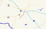
Maryland Route 351 is a state highway
in the U.S. state of Maryland
. Known as Ballenger Creek Pike, the state highway runs 4.24 miles (6.8 km) from the beginning of state maintenance near Adamstown
north to MD 180
and Interstate 70
(I-70) in Frederick
. MD 351 connects Frederick with its suburb of Ballenger Creek
and the rural region around Adamstown in southern Frederick County
. The state highway, which was originally MD 78, was constructed south of Ballenger Creek
in the late 1920s. The highway was extended north to U.S. Route 340
(US 340) in the late 1930s. Following the construction of the US 340 freeway in Frederick in the late 1960s, MD 180 assumed all of MD 78. MD 180 was rolled back to Frederick and the highway that had formerly been MD 78 was designated MD 351 in the late 1980s. In 2002 and 2003, MD 351 was temporarily removed from the state highway system when a portion of the highway was relocated due to construction of a high school.
just east of that state highway's western terminus at US 15
in Point of Rocks
, passing through an area of farmland that was once part of the Carrollton Manor
. MD 351 heads north as a two-lane road that crosses Tuscarora Creek
and passes through a mix of farmland and residential subdivisions. At Lambert Drive in the suburban community of Ballenger Creek, MD 351 becomes maintained by the Frederick County Division of Public Works. Within the 0.8 miles (1.3 km) county-maintained section, the highway passes through three curves as it crosses Ballenger Creek
and passes Tuscarora High School
.
MD 351 becomes state-maintained again at Corporate Drive, which heads east opposite the entrance to Ballenger Creek Park, which contains the George Widrick House
. Around Crestwood Boulevard, MD 351 gains a second lane northbound and temporarily becomes a divided highway. MD 351 reaches its northern terminus at Ballenger Center Drive at the Frederick city limits. The west leg of the intersection is a ramp to eastbound I-70 (Eisenhower Memorial Highway), which leads to southbound I-270
and eastbound US 40
. Ballenger Creek Pike continues north as MD 180, which provides access to US 15, US 340, westbound US 40, and westbound I-70 before curving west as Jefferson Pike toward Jefferson
.
MD 78's northern terminus was relocated when US 340 was reconstructed as a freeway in 1968. MD 78 and MD 180 were now co-terminus at the two highways' interchange with US 340. In 1970, MD 180 was extended south along Ballenger Creek Pike to what had been MD 78's southern terminus near Adamstown, resulting in a cane-shaped route. Around 1989, MD 180's eastern terminus was rolled back to Solarex Court at the southern end of its interchange with US 340 and US 15. MD 351 was assigned to Ballenger Creek Pike south of Solarex Court. The original MD 351 had been assigned to Main Street in Fruitland
in Wicomico County
through 1955. The ramp from MD 351 to eastbound I-70 was added around 1997.
MD 351 was removed from the state highway system in 2002. MD 180's eastern terminus was moved to its present location and the remainder of state-maintained Ballenger Creek Pike was transferred to Frederick County. The state highway was transferred to the county after the completion of a Maryland State Highway Administration
contract to eliminate a sharp curve in the highway between Lambert Drive and Corporate Drive and construct a new bridge over Ballenger Creek. Portions of the old road were reused on the campus of newly-constructed Tuscarora High School. In 2003, much of MD 351 was brought back into the state highway system; however, the Lambert Drive – Corporate Drive section remained under Frederick County maintenance.
.
{| class=wikitable
!Location
!Mile
!Destinations
!Notes
|-
|Adamstown
|0.00
|Ballenger Creek Pike south – Point of Rocks
|Southern terminus at beginning of state maintenance 6.77 miles (10.9 km) north of MD 28
in Point of Rocks
|-
|Frederick
|4.24
|
|Northern terminus at eastern terminus of MD 180; ramp from MD 351 to eastbound I-70
State highway
State highway, state road or state route can refer to one of three related concepts, two of them related to a state or provincial government in a country that is divided into states or provinces :#A...
in the U.S. state of Maryland
Maryland
Maryland is a U.S. state located in the Mid Atlantic region of the United States, bordering Virginia, West Virginia, and the District of Columbia to its south and west; Pennsylvania to its north; and Delaware to its east...
. Known as Ballenger Creek Pike, the state highway runs 4.24 miles (6.8 km) from the beginning of state maintenance near Adamstown
Adamstown, Maryland
Adamstown is an unincorporated community located in Frederick County, Maryland, USA. It is named for Adam Kohlenberg , a station agent and first town merchant who owned much of present-day Adamstown.- Events :...
north to MD 180
Maryland Route 180
Maryland Route 180 is a state highway in the U.S. state of Maryland. Known for most of its length as Jefferson Pike, the state highway runs from U.S. Route 340 in Knoxville east to MD 351 and Interstate 70 in Frederick. MD 180 is the old alignment of US 340 through Knoxville, Petersville, and...
and Interstate 70
Interstate 70 in Maryland
Interstate 70 is a part of the Interstate Highway System that runs from Cove Fort, Utah to Baltimore, Maryland. In Maryland, the Interstate Highway runs from the Pennsylvania state line in Hancock east to the Interstate's eastern terminus near its junction with I-695 at a park and ride in...
(I-70) in Frederick
Frederick, Maryland
Frederick is a city in north-central Maryland. It is the county seat of Frederick County, the largest county by area in the state of Maryland. Frederick is an outlying community of the Washington-Arlington-Alexandria, DC-VA-MD-WV Metropolitan Statistical Area, which is part of a greater...
. MD 351 connects Frederick with its suburb of Ballenger Creek
Ballenger Creek, Maryland
Ballenger Creek is a census-designated place in Frederick County, Maryland, United States. It is a part of the Frederick, Maryland urban area that is adjacent to Frederick's City limit on the South, with a 2010 Census population of 18,274...
and the rural region around Adamstown in southern Frederick County
Frederick County, Maryland
Frederick County is a county located in the western part of the U.S. state of Maryland, bordering the southern border of Pennsylvania and the northeastern border of Virginia. As of the 2010 Census, the population was 233,385....
. The state highway, which was originally MD 78, was constructed south of Ballenger Creek
Ballenger Creek
Ballenger Creek is a tributary of the Monocacy River in Frederick County, Maryland. The headwaters of the creek are located on the east slope of Catoctin Mountain, about west of the city of Frederick. The stream runs roughly southeast to the Monocacy National Battlefield and the confluence with...
in the late 1920s. The highway was extended north to U.S. Route 340
U.S. Route 340 in Maryland
U.S. Route 340 is a part of the U.S. Highway System that runs from Greenville, Virginia to Frederick, Maryland. In Maryland, the U.S. highway runs from the Virginia state line at the Potomac River at Sandy Hook east to its northern terminus at US 15 and US 40 in Frederick...
(US 340) in the late 1930s. Following the construction of the US 340 freeway in Frederick in the late 1960s, MD 180 assumed all of MD 78. MD 180 was rolled back to Frederick and the highway that had formerly been MD 78 was designated MD 351 in the late 1980s. In 2002 and 2003, MD 351 was temporarily removed from the state highway system when a portion of the highway was relocated due to construction of a high school.
Route description
MD 351 begins at an arbitrary spot between Manor Woods Road and Dover Drive in the hamlet of Church Hill near Adamstown. Ballenger Creek Pike continues as a county highway that runs 6.77 miles (10.9 km) southwest along the western edge of Adamstown to MD 28Maryland Route 28
Maryland Route 28 is a state highway in the U.S. state of Maryland. The state highway runs from U.S. Route 15 in Point of Rocks east to MD 182 in Norwood. The western portion of MD 28 is a rural highway connecting several villages in southern Frederick County and western Montgomery County...
just east of that state highway's western terminus at US 15
U.S. Route 15 in Maryland
U.S. Route 15 is a part of the U.S. Highway System that runs from Walterboro, South Carolina to Painted Post, New York. In Maryland, the highway runs from the Virginia state line at the Potomac River in Point of Rocks north to the Pennsylvania state line near Emmitsburg. US 15 is...
in Point of Rocks
Point of Rocks, Maryland
Point of Rocks is a community in Frederick County, Maryland. It is named for the striking rock formation on the adjacent Catoctin Mountain, which were formed by the Potomac River cutting through the ridge in a water gap, a typical formation in the Ridge-and-Valley Appalachians...
, passing through an area of farmland that was once part of the Carrollton Manor
Carrollton Manor
Carrollton Manor was a 17,000 acre tract of land in Frederick County, Maryland which extended from the Potomac River on the south, Catoctin Mountain to the west, the Monocacy River to the east, and Ballenger Creek to the north...
. MD 351 heads north as a two-lane road that crosses Tuscarora Creek
Tuscarora Creek (Potomac River)
Tuscarora Creek is a tributary of the Potomac River in Frederick County, Maryland, in the United States.The creek rises east of the community of Jefferson, about southwest of the city of Frederick, and flows south to its mouth at the Potomac.-References:...
and passes through a mix of farmland and residential subdivisions. At Lambert Drive in the suburban community of Ballenger Creek, MD 351 becomes maintained by the Frederick County Division of Public Works. Within the 0.8 miles (1.3 km) county-maintained section, the highway passes through three curves as it crosses Ballenger Creek
Ballenger Creek
Ballenger Creek is a tributary of the Monocacy River in Frederick County, Maryland. The headwaters of the creek are located on the east slope of Catoctin Mountain, about west of the city of Frederick. The stream runs roughly southeast to the Monocacy National Battlefield and the confluence with...
and passes Tuscarora High School
Tuscarora High School
Tuscarora High School is a secondary school located at 5312 Ballenger Creek Pike in Frederick, the third-largest city in Maryland, USA.-History:...
.
MD 351 becomes state-maintained again at Corporate Drive, which heads east opposite the entrance to Ballenger Creek Park, which contains the George Widrick House
George Widrick House
The George Widrick House is a historic home located at Frederick, Frederick County, Maryland, United States. It is a -story Federal period brick dwelling, with a 2-story service wing...
. Around Crestwood Boulevard, MD 351 gains a second lane northbound and temporarily becomes a divided highway. MD 351 reaches its northern terminus at Ballenger Center Drive at the Frederick city limits. The west leg of the intersection is a ramp to eastbound I-70 (Eisenhower Memorial Highway), which leads to southbound I-270
Interstate 270 (Maryland)
Interstate 270 is a auxiliary Interstate Highway in the U.S. state of Maryland that travels between Interstate 495 just north of Bethesda, Montgomery County and Interstate 70 in the city of Frederick in Frederick County. It consists of the mainline as well as a spur that provides access to and...
and eastbound US 40
U.S. Route 40 in Maryland
U.S. Route 40 in the U.S. state of Maryland runs from western Maryland to Cecil County in the state's northeastern corner. With a total length of over , it is the longest numbered highway in Maryland. Almost half of the road overlaps with Interstate 68 or Interstate 70, while the old alignment...
. Ballenger Creek Pike continues north as MD 180, which provides access to US 15, US 340, westbound US 40, and westbound I-70 before curving west as Jefferson Pike toward Jefferson
Jefferson, Maryland
Jefferson is an unincorporated community located in Frederick County, Maryland, established in 1774, incorporated as a town in 1831. However, a year later, in 1832, the citizens of the town decided that municipal government was unnecessary, thus, it was disincorporated.- History of Jefferson...
.
History
MD 351 follows what was originally the Frederick and Ballinger Creek Turnpike from Ballenger Creek north to the Frederick and Jefferson Turnpike, which was succeeded by US 340 and later MD 180. A concrete road was built along the path of the turnpike from Ballenger Creek to south of Elmer Derr Road in 1926 and 1927. The concrete road was extended south to Renn Road in 1928 and to MD 351's present southern terminus near Adamstown in 1929 and 1930. The paved section of what became MD 78 was connected to US 340 by a county highway until the county highway was brought into the state system in 1938.MD 78's northern terminus was relocated when US 340 was reconstructed as a freeway in 1968. MD 78 and MD 180 were now co-terminus at the two highways' interchange with US 340. In 1970, MD 180 was extended south along Ballenger Creek Pike to what had been MD 78's southern terminus near Adamstown, resulting in a cane-shaped route. Around 1989, MD 180's eastern terminus was rolled back to Solarex Court at the southern end of its interchange with US 340 and US 15. MD 351 was assigned to Ballenger Creek Pike south of Solarex Court. The original MD 351 had been assigned to Main Street in Fruitland
Fruitland, Maryland
Fruitland is a city in Wicomico County, Maryland, United States. The population was 4,866 at the 2010 census. It is included in the Salisbury, Maryland Metropolitan Statistical Area.-Geography:Fruitland is located at ....
in Wicomico County
Wicomico County, Maryland
As of the census of 2010, there were 98,733 people, 37,220 households, and 24,172 families residing in the county. The population density was 261.7 people per square mile . There were 41,192 housing units at an average density of 109.2 per square mile...
through 1955. The ramp from MD 351 to eastbound I-70 was added around 1997.
MD 351 was removed from the state highway system in 2002. MD 180's eastern terminus was moved to its present location and the remainder of state-maintained Ballenger Creek Pike was transferred to Frederick County. The state highway was transferred to the county after the completion of a Maryland State Highway Administration
Maryland State Highway Administration
The Maryland State Highway Administration is the state agency responsible for maintaining Maryland numbered highways outside of Baltimore City...
contract to eliminate a sharp curve in the highway between Lambert Drive and Corporate Drive and construct a new bridge over Ballenger Creek. Portions of the old road were reused on the campus of newly-constructed Tuscarora High School. In 2003, much of MD 351 was brought back into the state highway system; however, the Lambert Drive – Corporate Drive section remained under Frederick County maintenance.
Junction list
The entire route is in Frederick CountyFrederick County, Maryland
Frederick County is a county located in the western part of the U.S. state of Maryland, bordering the southern border of Pennsylvania and the northeastern border of Virginia. As of the 2010 Census, the population was 233,385....
.
{| class=wikitable
!Location
!Mile
!Destinations
!Notes
|-
|Adamstown
Adamstown, Maryland
Adamstown is an unincorporated community located in Frederick County, Maryland, USA. It is named for Adam Kohlenberg , a station agent and first town merchant who owned much of present-day Adamstown.- Events :...
|0.00
|Ballenger Creek Pike south – Point of Rocks
Point of Rocks, Maryland
Point of Rocks is a community in Frederick County, Maryland. It is named for the striking rock formation on the adjacent Catoctin Mountain, which were formed by the Potomac River cutting through the ridge in a water gap, a typical formation in the Ridge-and-Valley Appalachians...
|Southern terminus at beginning of state maintenance 6.77 miles (10.9 km) north of MD 28
Maryland Route 28
Maryland Route 28 is a state highway in the U.S. state of Maryland. The state highway runs from U.S. Route 15 in Point of Rocks east to MD 182 in Norwood. The western portion of MD 28 is a rural highway connecting several villages in southern Frederick County and western Montgomery County...
in Point of Rocks
Point of Rocks, Maryland
Point of Rocks is a community in Frederick County, Maryland. It is named for the striking rock formation on the adjacent Catoctin Mountain, which were formed by the Potomac River cutting through the ridge in a water gap, a typical formation in the Ridge-and-Valley Appalachians...
|-
|Frederick
Frederick, Maryland
Frederick is a city in north-central Maryland. It is the county seat of Frederick County, the largest county by area in the state of Maryland. Frederick is an outlying community of the Washington-Arlington-Alexandria, DC-VA-MD-WV Metropolitan Statistical Area, which is part of a greater...
|4.24
|
|Northern terminus at eastern terminus of MD 180; ramp from MD 351 to eastbound I-70