

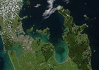
Firth of Thames
Encyclopedia
Headlands and bays
Headlands and bays are two related features of the coastal environment.- Geology and geography :Headlands and bays are often found on the same coastline. A bay is surrounded by land on three sides, whereas a headland is surrounded by water on three sides. Headlands are characterized by high,...
located in the north of the North Island
North Island
The North Island is one of the two main islands of New Zealand, separated from the much less populous South Island by Cook Strait. The island is in area, making it the world's 14th-largest island...
of New Zealand
New Zealand
New Zealand is an island country in the south-western Pacific Ocean comprising two main landmasses and numerous smaller islands. The country is situated some east of Australia across the Tasman Sea, and roughly south of the Pacific island nations of New Caledonia, Fiji, and Tonga...
. It is the firth
Firth
Firth is the word in the Lowland Scots language and in English used to denote various coastal waters in Scotland and England. In mainland Scotland it is used to describe a large sea bay, or even a strait. In the Northern Isles it more usually refers to a smaller inlet...
of the rivers Waihou
Waihou River
thumb|The Waihou River near [[Putaruru]]The Waihou River is located in the northern North Island of New Zealand. Its former name, Thames River, was bestowed by Captain James Cook....
and Piako
Piako River
The Piako River is a lowland river system that drains into the Firth of Thames on the North Island of New Zealand. Together with the Waihou River, it is one of the two main rivers systems which drains the Hauraki Plains...
, the former of which was formerly named the Thames River, and the town of Thames
Thames, New Zealand
Thames is a town at the southwestern end of the Coromandel Peninsula in New Zealand's North Island. It is located on the Firth of Thames close to the mouth of the Waihou River. The town is the seat of the Thames-Coromandel District Council....
lies on its southeastern coast.
Its original name is Tikapa.
The firth lies at the southern end of the Hauraki Gulf
Hauraki Gulf
The Hauraki Gulf is a coastal feature of the North Island of New Zealand. It has a total area of 4000 km², and lies between the Auckland Region, the Hauraki Plains, the Coromandel Peninsula and Great Barrier Island...
, southeast of the city of Auckland
Auckland
The Auckland metropolitan area , in the North Island of New Zealand, is the largest and most populous urban area in the country with residents, percent of the country's population. Auckland also has the largest Polynesian population of any city in the world...
. It occupies a rift valley
Rift valley
A rift valley is a linear-shaped lowland between highlands or mountain ranges created by the action of a geologic rift or fault. This action is manifest as crustal extension, a spreading apart of the surface which is subsequently further deepened by the forces of erosion...
or graben
Graben
In geology, a graben is a depressed block of land bordered by parallel faults. Graben is German for ditch. Graben is used for both the singular and plural....
between the Coromandel Peninsula
Coromandel Peninsula
The Coromandel Peninsula lies in the North Island of New Zealand. It is part of the Waikato Region and Thames-Coromandel District and extends 85 kilometres north from the western end of the Bay of Plenty, forming a natural barrier to protect the Hauraki Gulf and the Firth of Thames in the west...
and Hunua Ranges
Hunua Ranges
The Hunua Ranges form a block of hilly country to the southeast of Auckland in New Zealand's North Island. They cover some 250 square kilometres , containing 178 km² of parkland, and rise to 688 metres at Kohukohunui...
which continues into the Hauraki Plains
Hauraki Plains
The Hauraki Plains are a geographical feature and non-administrative area located in the northern North Island of New Zealand, at the lower end of the Thames Valley...
to the south.
Conservation
The Firth of Thames is an important site for waderWader
Waders, called shorebirds in North America , are members of the order Charadriiformes, excluding the more marine web-footed seabird groups. The latter are the skuas , gulls , terns , skimmers , and auks...
s or shorebirds, and is listed as a wetland of international importance under the Ramsar Convention
Ramsar Convention
The Ramsar Convention is an international treaty for the conservation and sustainable utilization of wetlands, i.e., to stem the progressive encroachment on and loss of wetlands now and in the future, recognizing the fundamental ecological functions of wetlands and their economic, cultural,...
. The Miranda Shorebird Centre, operated by the Miranda Naturalists' Trust
Miranda Naturalists' Trust
The Miranda Naturalists' Trust is a charitable trust, that established and maintains the Miranda Shorebird Centre, located at Miranda on the western shore of the Firth of Thames on the North Island of New Zealand. The Miranda Naturalists' Trust was formed in 1975 to encourage people to visit the...
, is located on the western shore of the bay at Miranda
Miranda, New Zealand
Miranda is a historical fort and small village in the Firth of Thames, New Zealand, which is now best known as the location of the Miranda Shorebird Centre, owned and operated by the Miranda Naturalists' Trust...
.
However, the firth overall is severely damaged by man-made influences, especially dairy-farm run-off, and has not recovered from large-scale mussel dredging over 40 years after the practice ceased (more information in the Hauraki Gulf
Hauraki Gulf
The Hauraki Gulf is a coastal feature of the North Island of New Zealand. It has a total area of 4000 km², and lies between the Auckland Region, the Hauraki Plains, the Coromandel Peninsula and Great Barrier Island...
article).