

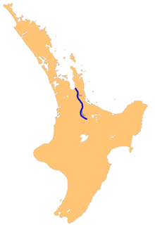
Waihou River
Encyclopedia
North Island
The North Island is one of the two main islands of New Zealand, separated from the much less populous South Island by Cook Strait. The island is in area, making it the world's 14th-largest island...
of New Zealand
New Zealand
New Zealand is an island country in the south-western Pacific Ocean comprising two main landmasses and numerous smaller islands. The country is situated some east of Australia across the Tasman Sea, and roughly south of the Pacific island nations of New Caledonia, Fiji, and Tonga...
. Its former name, Thames River, was bestowed by Captain James Cook
James Cook
Captain James Cook, FRS, RN was a British explorer, navigator and cartographer who ultimately rose to the rank of captain in the Royal Navy...
.
The river flows north for 150 kilometres from the Mamaku Ranges
Mamaku Ranges
The Mamaku Ranges are a range of rugged hills in the North Island of New Zealand. Located to the west of Lake Rotorua and north of Lake Taupo, they lie to the immediate south of the Kaimai Range and can be thought of as an extension of it, in much the same way that the Kaimai Range can be...
past the towns of Putaruru
Putaruru
Putaruru is a small town in the Waikato region of New Zealand's North Island. It is on the Oraka River 65 kilometres south-east of Hamilton....
, Te Aroha
Te Aroha
Te Aroha is a rural town in the Waikato region of New Zealand with a population of 3,768 . It is 53 km northeast of Hamilton and 50 km south of Thames. It sits at the foot of 952-metre Mount Te Aroha, the highest point in the Kaimai Range....
, and Paeroa
Paeroa
Paeroa is a small town in New Zealand, in the northern Waikato region of the Thames Valley. Located at the foot of the Coromandel Peninsula, it is close to the junction of the Waihou and Ohinemuri Rivers, 20 kilometres from the coast at the Firth of Thames...
, before reaching the Firth of Thames
Firth of Thames
The Firth of Thames is a large bay located in the north of the North Island of New Zealand. It is the firth of the rivers Waihou and Piako, the former of which was formerly named the Thames River, and the town of Thames lies on its southeastern coast....
at the south end of the Hauraki Gulf
Hauraki Gulf
The Hauraki Gulf is a coastal feature of the North Island of New Zealand. It has a total area of 4000 km², and lies between the Auckland Region, the Hauraki Plains, the Coromandel Peninsula and Great Barrier Island...
near the town of Thames
Thames, New Zealand
Thames is a town at the southwestern end of the Coromandel Peninsula in New Zealand's North Island. It is located on the Firth of Thames close to the mouth of the Waihou River. The town is the seat of the Thames-Coromandel District Council....
. In its lower reaches, the river and the nearby Piako River
Piako River
The Piako River is a lowland river system that drains into the Firth of Thames on the North Island of New Zealand. Together with the Waihou River, it is one of the two main rivers systems which drains the Hauraki Plains...
form the wide alluvial Hauraki Plains
Hauraki Plains
The Hauraki Plains are a geographical feature and non-administrative area located in the northern North Island of New Zealand, at the lower end of the Thames Valley...
.
Just before the river reaches the ocean, State Highway
New Zealand State Highway network
The New Zealand State Highway network is the major national highway network in New Zealand. Just under 100 roads in both the North and South Islands are State Highways...
25 crosses the river over the Kopu Bridge
Kopu Bridge
The Kopu Bridge is a single-lane swing bridge that spans the Waihou River, near its emergence into the Firth of Thames in the Thames-Coromandel District of New Zealand's North Island. The bridge was completed in 1928 and is part of State Highway 25...
, the longest single lane bridge in the country at 463m and the only remaining swing bridge
Swing bridge
A swing bridge is a movable bridge that has as its primary structural support a vertical locating pin and support ring, usually at or near to its centre of gravity, about which the turning span can then pivot horizontally as shown in the animated illustration to the right...
on a New Zealand state highway. The bridge is infamous for the queues of vehicles travelling to and from the Coromandel Peninsula
Coromandel Peninsula
The Coromandel Peninsula lies in the North Island of New Zealand. It is part of the Waikato Region and Thames-Coromandel District and extends 85 kilometres north from the western end of the Bay of Plenty, forming a natural barrier to protect the Hauraki Gulf and the Firth of Thames in the west...
.