

Eglinton Country Park
Encyclopedia
Eglinton Country Park is located in the grounds of the old Eglinton Castle estate, Kilwinning
Kilwinning
Kilwinning is a historic town in North Ayrshire, Scotland. It is known as The Crossroads of Ayrshire. The 2001 Census recorded it as having a population of 15,908.-History:...
, North Ayrshire
North Ayrshire
North Ayrshire is one of 32 council areas in Scotland with a population of roughly 136,000 people. It is located in the south-west region of Scotland, and borders the areas of Inverclyde to the north, Renfrewshire to the north-east and East Ayrshire and South Ayrshire to the East and South...
, Scotland
Scotland
Scotland is a country that is part of the United Kingdom. Occupying the northern third of the island of Great Britain, it shares a border with England to the south and is bounded by the North Sea to the east, the Atlantic Ocean to the north and west, and the North Channel and Irish Sea to the...
(map reference NS 3227 4220). Eglinton Park is situated in the parish
Parish
A parish is a territorial unit historically under the pastoral care and clerical jurisdiction of one parish priest, who might be assisted in his pastoral duties by a curate or curates - also priests but not the parish priest - from a more or less central parish church with its associated organization...
of Kilwinning, part of the former district of Cunninghame
Cunninghame
Cunninghame is a former comital district of Scotland and also a district of the Strathclyde Region from 1975–1996.-Historic Cunninghame:The historic district of Cunninghame was bordered by the districts of Renfrew and Clydesdale to the north and east respectively, by the district of Kyle to the...
, and covers an area of 400 hectares (98 acres (39.7 ha) of which are woodland). The central iconic feature of the country park is the ruined Eglinton Castle
Eglinton Castle
Eglinton Castle was a large Gothic castellated mansion in Kilwinning, North Ayrshire, Scotland.-The castle :The ancient seat of the Earls of Eglinton, it is located just south of the town of Kilwinning...
, once home to the Eglinton family and later the Montgomeries, Earls of Eglinton
Earl of Eglinton
Earl of Eglinton is a title in the Peerage of Scotland.Some authorities spell the title: Earl of Eglintoun In 1859 the thirteenth Earl of Eglinton, Archibald Montgomerie, was also created Earl of Winton in the Peerage of the United Kingdom, which gave him an automatic seat in the House of Lords,...
and chiefs of the Clan Montgomery
Clan Montgomery
-Origins of the Clan:Clan Montgomery originated in Wales, and emigrated to Scotland in the 12th century as vassals of the FitzAlans. The family derives its surname from lands in Wales, likely from the Honour of Montgomery which was located near the Shropshire lands of the FitzAlans...
. Eglinton Country Park is managed and maintained by North Ayrshire Council and its Ranger Service.
Location
Eglinton is a one hour drive from GlasgowGlasgow
Glasgow is the largest city in Scotland and third most populous in the United Kingdom. The city is situated on the River Clyde in the country's west central lowlands...
, accessed via the M77
M77 motorway
The M77 motorway is a motorway in Scotland. It originally began in southern Glasgow at the M8 motorway at Kinning park, and terminates near Kilmarnock at the village of Fenwick. However, changes were made in autumn 2005 segregating a lane on the M8 motorway almost as far as the Kingston Bridge,...
to Kilmarnock
Kilmarnock
Kilmarnock is a large burgh in East Ayrshire, Scotland, with a population of 44,734. It is the second largest town in Ayrshire. The River Irvine runs through its eastern section, and the Kilmarnock Water passes through it, giving rise to the name 'Bank Street'...
, followed by the A71
A71 road
The A71 is a major road in Scotland linking Edinburgh with Lanarkshire and Ayrshire. It adjoins the Livingston Bypass A899.It runs south west from Edinburgh for approximately 70 miles, through Saughton, Wilkieston and south of Livingston, Whitburn and Wishaw, then by way of the Garrion Bridge,...
to Irvine, and then the A78
A78 road
The A78 is an A road in Scotland. It connects Greenock and Prestwick on a route which follows the northern section of the Ayrshire coast.-Route:...
(T) to Eglinton Junction on the outskirts of Kilwinning. It is a 30 minute walk from Kilwinning town centre along the banks of the River Garnock
River Garnock
The River Garnock, the smallest of Ayrshire's six principal rivers, has its source on the southerly side of the Hill of Stake in the heart of the Clyde Muirshiel Regional Park. About a mile and a half south of this starting point the untested stream tumbles over the Spout of Garnock, the highest...
or by the A737 Irvine - Kilwinning road. A regular bus service also runs by the western entrance to the park.
Eglinton is mostly a free facility, with no parking charges or entry fee; permits are required for fishing and horse riding; some facilities are charged for, such as the holiday cottage located next to the Racket Hall, the Visitor Facility Block and the use of the events fields.
Facilities within the park
In 2011 a new play area opened on the site of the old farm animal enclosures. This facility is the second largest in Ayrshire, designed for use by adults, adolescents, and younger children. The area includes equipment designed specifically for the disabled. A sensory garden is part of the complex, and musical instruments are part of the entertainment.Eglinton has a number of established walks in woodlands, around the loch or through the Clement Wilson Gardens. Picnic areas are provided, a Visitor Centre, several children's play areas, bird watching facilities, etc. Car parking is available, with an overflow or auxiliary 'grass' car park. A dedicated bus park has spaces for 5 coaches. Touring caravan stands are located near the Visitor Facility Block close to the main Events Field.
The Visitor Centre is the interpretation area and holds an exhibition on the history of the park with an emphasis on the Montgomery Clan, the Earls of Eglinton, and the famous Eglinton Tournament of 1839
Eglinton Tournament of 1839
The Eglinton Tournament of 1839 was a re-enactment of a medieval joust and revel held in Scotland on Friday 30 August.It was funded and organized by Archibald Montgomerie, 13th Earl of Eglinton, and took place at Eglinton Castle, near Kilwinning in Scotland...
. It has a wide range of information leaflets and the gift shop is stocked with souvenirs, books, etc. The Tournament Cafe is close to the Visitor Centre.
Full wheelchair access exists and other facilities for disabled visitors are provided, such as a motorised hoist. A mobility scooter and wheelchair loan service operates from the Visitor Centre, with advanced booking advisable. A Campsite Field is available for organised groups such as Scouts, Guides, etc. The visitor facility block has toilets, showers and a dayroom. A dedicated equestrian practise area exists in a bark covered arena. A charge is made for these facilities.
Eglinton Country Park is served by the North Ayrshire Council Ranger Service who offer a programme of guided walks (lasting from 1 to 2 hours) and events from Easter and July - October. The Visitor Centre is open from 10 am to 4 pm, 7 days a week from Easter to October. The park is open all year, dawn to dusk. The Acorn Club runs from October to March on Saturday mornings. Applications are taken from 1 September.
The park is a contact for pupils and teachers taking part in 'Eco Schools' projects and the rangers are also a contact for 'Scottish Outdoor Access', the code and further details of access to the countryside. Rangers are involved in provision Curriculum for Excellence activities.
Dogs are welcome as long as they are kept under control; the park is listed as 'Friendly Venue' by the Dog's Trust.
Spier's outstation

Beith
Beith is a small town situated in the Garnock Valley in North Ayrshire, Scotland approximately 20-miles south-west of Glasgow. The town is situated on the crest of a hill and was known originally as the "Hill o' Beith" after its Court Hill.-History:-Name:Beith's name is thought to emanate from...
are an outstation for Eglinton Country Park, serving as a multi-purpose facility for the communities of the Garnock valley (Dalry, Glengarnock, Kilbirnie, Longbar, Beith, and Barrmill). Spier's parklands are staffed by the NAC Garnock Valley Ranger. The Friends of Spiers (FoS) are a group based at the outstation, dedicated to the enhancement and maintenance of Spier's Old School Grounds. Spier's is owned by the Spier's Trust and leased by NAC. It has a network of wheelchair friendly paths and other informal routes which are surfaced with bark chips.
Activities
Two children's playparks are provided, one near the Visitor Centre and the other near the castle ruins. There are wet weather shelters. The Rackets Hall can be hired for birthday parties, conferences, exhibitions, and other events. A soft play facility is located for hire within the Rackets Hall.Equestrian rides (Bridle paths)
Within the park there is an extensive bridle path network extending to around 11 km. Of this route a shared paths makes up about 5 km of the route on which riders must give way to walkers and cyclists. The track meanders pleasantly beside fields and woodlands.Eglinton loch and the Lugton Water
The 6.5 ha loch, 6 metres deep, was created in 1975 through the extraction of materials used in the construction of the A 78 (T) Irvine and Kilwinning bypass. It is marked on old maps as being an area liable to flooding and was the site of the jousting matches at the 1839 Eglinton Tournament. It is well stocked with coarse fish, and is a popular spot for anglers and bird watchers. The Lugton Water runs through the park and several weirs were built at intervals along the river to raise the water level for ornamental reasons. Several mills were powered by the Lugton Water as shown by names such as 'North and South Millburn', situated near the hamlet of Benslie. The 12th Earl (1740–1819) altered the course of the Lugton Water.The Irvine New Town Trail
The Irvine New Town TrailIrvine New Town Trail
The Irvine New Town Trail is a recreational cycle path in Irvine, North Ayrshire, Scotland. The route is long.The trail is used by many dog walkers and cyclists in the area. The route forms a ring as there are no start and end points. The trail passes through Irvine's Low Green, and goes up to...
is a 19 km (11.8 mi) long cycle path used by many joggers, walkers, dog walkers and cyclists in the area. The route forms a ring as there are no start and end points. The trail passes through Irvine's low green, and goes up to Kilwinning's Woodwynd and Blackland's area. The route passes through the Eglinton Country Park, carries on to Girdle Toll
Girdle Toll
Girdle Toll is a small village on the outskirts of Irvine, North Ayrshire.-Geography:It is situated off the Stanecastle Roundabout just next to the Stanecastle Keep. The village is from Prestwick Airport and only from the city of Glasgow....
, Bourtreehill
Bourtreehill
Bourtreehill is a housing scheme which forms part of the Irvine New Town in North Ayrshire, Scotland.- Etymology :A 'Bour Tree' is the Ayrshire name for the Common Elder tree, Sambucus nigra, often found in the older and more biodiverse local woodlands....
, Broomlands
Broomlands
Broomlands is district of Irvine in North Ayrshire, Scotland. Situated on a series of bends in the River Annick, Broomlands and its original features are now almost lost within the south-Bourtreehill and Broomlands housing scheme.-History:...
, Dreghorn
Dreghorn
Dreghorn is a village near Irvine, North Ayrshire, Scotland. This parish comprehends the old parishes of Dreghorn and Pearston, which were united in 1668. The whole of the parish was historically the property of the De Morvilles, who were Constables of Scotland and Lords of Cunninghame...
and carries on to the Irvine Riverside and back to the Mall and the Low Green again.
The Belvedere Hill and other pedestrian areas
A plantation is situated on 'Belvedere Hill' (the term 'Belvedere or Belvidere' literally means 'beautiful view') (until 2011 it also had a large classical central 'follyFolly
In architecture, a folly is a building constructed primarily for decoration, but either suggesting by its appearance some other purpose, or merely so extravagant that it transcends the normal range of garden ornaments or other class of building to which it belongs...
' feature) and vistas radiating out from a central hub, technically termed 'rond-points' (plantations located on rising ground with several vistas radiating from a central point). This style of woodlands and vistas or rides is a restoration of the layout of the entire area surrounding the castle in the 1750s prior to the remodeling which was completed by 1802. General Roy's map of 1747 - 52 shows that the ornamental woodlands were a series of these radiating rond-points of different sizes, sometimes overlapping each other. The 'old' Eglinton Park farm, circa 1950s, lies to one side of this feature. Many other footpaths are present, a number of which are not shared with cyclists or horses.
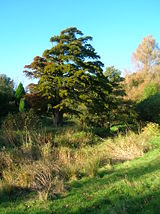
Views within Eglinton Country Park
Birds
i) Recent resident breeding species include: Robins, finches, tits, Thrush, Pheasant, Grey Partridge, Tawny Owl, Kestrel, Sparrowhawk, Great Spotted Woodpecker, Skylark, Yellowhammer, Tree-creeper.ii) Resident (but non-breeding): Buzzard.
Winter visitors: Fieldfares, Redwings, occasional Waxwings and sightings of Hen Harrier and Kingfisher.
iii) Wildfowl include: Goldeneye, Wigeon, Tufted and Mallard ducks with Whooper Swans and geese on passage. Also Woodcock, Snipe, Curlew and Lapwing.
iv) Summer migrants: Swifts, Swallows and Martins; Willow, Sedge and Grasshopper Warblers, Blackcap and Chiffchaff. Exotic sightings include cuckoos, White Stork, Black Swan a Flamingo!.
Mammals
Hedgehogs, foxes, moles, pipistrelle bats, mink and roe deer are found in the park and may be seen with luck or by being patient and silent.Other wildlife
Surveys carried out by the Scottish Wildlife TrustScottish Wildlife Trust
The Scottish Wildlife Trust is a registered charity dedicated to conserving the wildlife and natural environment of Scotland.-Description:The Scottish Wildlife Trust has over 32,800 members...
and others have shown that the park also has a good variety of mushroom, bracket, jelly and other species of fungi. The park has a good gall
Gall
Galls or cecidia are outgrowths on the surface of lifeforms caused by invasion by other lifeforms, such as parasites or bacterial infection. Plant galls are abnormal outgrowths of plant tissues and can be caused by various parasites, from fungi and bacteria, to insects and mites...
diversity, such as knopper
Knopper gall
Andricus quercuscalicis is a gall wasp species inducing Knopper galls.Knopper galls develop as a chemically induced distortion of growing acorns on Pedunculate Oak trees, caused by gall wasps, which lay eggs in buds with their ovipositor...
on acorns, tongue on alders, robin's pincushion or rose bedeguar gall on wild rose, cola nut on oak and witch's broom
Witch's broom
A Witch's broom is a disease or deformity in a woody plant, typically a tree, where the natural structure of the plant is changed. A dense mass of shoots grows from a single point, with the resulting structure resembling a broom or a bird's nest....
on birch.
The 'Old Wood' containing the ice house has a good plant diversity due to the fact that it is long established and relatively undisturbed, unlike the park's plantations which are of a comparatively recent origin. Chapelholms wood shows a similar high biodiversity. Plants such as Dog's Mercury
Dog's Mercury
Mercurialis perennis, commonly known as dog's mercury, is a woodland plant found in much of Europe, but almost absent from Ireland, Orkney and Shetland. A member of the spurge family , it is a herbaceous, downy perennial with erect stems bearing simple, serrate leaves. The dioecious inflorescences...
, Tussock grass, bluebells and Honeysuckle
Honeysuckle
Honeysuckles are arching shrubs or twining vines in the family Caprifoliaceae, native to the Northern Hemisphere. There are about 180 species of honeysuckle, 100 of which occur in China; Europe, India and North America have only about 20 native species each...
are indicators of old deciduous
Deciduous
Deciduous means "falling off at maturity" or "tending to fall off", and is typically used in reference to trees or shrubs that lose their leaves seasonally, and to the shedding of other plant structures such as petals after flowering or fruit when ripe...
woodlands. Snowdrops are a highlight of spring in the park. A few specimen trees from the estate days survive, especially Sycamore
Sycamore Maple
Acer pseudoplatanus, the sycamore maple, is a species of maple native to central Europe and southwestern Asia, from France east to Ukraine, and south in mountains to northern Spain, northern Turkey, and the Caucasus. It is not related to other trees called sycamore or plane tree in the Platanus...
s (Acer pseudoplatanus) or Plane trees as they are traditionally known in Scotland. The park is one of the relatively few sites in Scotland where the Upright Hedge Bedstraw (Galium album
Galium album
Galium album. Miller. is a herbaceous annual plant of the family Rubiaceae...
) grows.
Species conservation
The park is acting as a part of the conservation effort to ensure the survival of three species of the rare indigenousIndigenous (ecology)
In biogeography, a species is defined as native to a given region or ecosystem if its presence in that region is the result of only natural processes, with no human intervention. Every natural organism has its own natural range of distribution in which it is regarded as native...
and endemic trees commonly called the Arran Whitebeams, native to that island and found nowhere else in the World. Chapelholms Wood has been designated as a Wildlife Site by the Scottish Wildlife Trust in recognition of the quality of its habitats and the species diversity it exhibits.
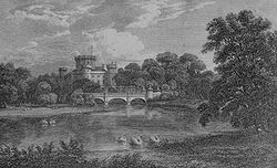
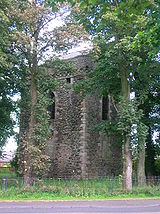
The castle
The original castle of the Eglintons may have been near Kidsneuk, Bogside (NS 309 409) where a substantial earth mound or motte stands and excavated pottery was found tentatively dating the site to the thirteenth century.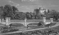
This engraving shows three arches and other differences compare with the Tournament bridge. It was the bridge that preceded it.
The earliest known castle, which even then was the chief seat of the Montgomeries, was burned by the Cunninghames of Glencairn in 1528 and rebuilt afterwards. The mill was also destroyed as well as the muniment chests containing the Montgomerie charters, etc.
Bedlam
Bedlam may refer to:* Bethlem Royal Hospital, London hospital first to specialise in the mentally ill and origin of the word "bedlam" describing chaos or madness-Places:* Bedlam, North Yorkshire, a village in England...
, this being where the Montgomerie's children had their rooms. The central saloon of the castle was 36 feet (11 m) in diameter and reached up the whole height of the castle, some 100 feet (30.5 m). The Category B Listed 1802 castle was un-roofed in 1929, being in poor structural condition after the contents sale of 1925, and fell into ruins.
Amongst many items of interest, the castle contained a chair built from the oak timbers of Alloway
Alloway
Alloway is best known as the birthplace of Robert Burns, and as where he set his poem "Tam o' Shanter"....
kirk and the back of the chair was inlaid with a brass plaque which bore the whole of Burn's poem 'Tam o' Shanter'. This was old off, together with much of the family paintings, the Earl's suit of armour, etc. at the 1925 sale of centents.
4 Commando
Commando
In English, the term commando means a specific kind of individual soldier or military unit. In contemporary usage, commando usually means elite light infantry and/or special operations forces units, specializing in amphibious landings, parachuting, rappelling and similar techniques, to conduct and...
and the Royal Engineers used it for exercises during the second world war, destroying two of the towers, and it was also used for naval gunnery practice. In the 1950s further damage was done and the remains were finally demolished to the level they are today (2007) in 1973. The house reputedly had 365 windows, one for each day of the year.
Groome in 1903 had stated that Everything about the castle contributes to an imposing display of splendid elegance and refined taste. An escape tunnel is said to run from the old castle to the area of the rockery on the castle lawns. The appearance of the old waterfall may have inspired this story as it looks like a sealed doorway.
The park and gardens
The park was used as a training camp; for vehicle maintenance and as a preparation depot for the Normandys and North Africa landings during World War II. The remnants of this era are visible in the form of Nissen hutNissen hut
A Nissen hut is a prefabricated steel structure made from a half-cylindrical skin of corrugated steel, a variant of which was used extensively during World War II.-Description:...
s, still in use today and the foundations of other wartime buildings. The army left the estate in a very dilapidated condition with abandoned vehicles left in a number of places. The partly buried remains of vehicles still exist in places.
.jpg)
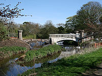
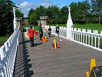
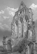
Eglinton Tournament Bridge
The Eglinton Tournament Bridge is a bridge located within Eglinton Country Park near Kilwinning, North Ayrshire, Scotland. The bridge crosses the Lugton Water a short distance northwest of Eglinton Castle and was named after the Eglinton Tournament of 1839...
may have been originally designed by the famous architect David Hamilton
David Hamilton
David Hamilton or Dave Hamilton or Davey Hamilton may refer to:*David Hamilton of Cadzow, 3rd Laird of Cadzow Scottish nobleman*David Hamilton Scottish architect...
. An older bridge with three arches, the one actually used for the 1839 Tournament, had stood further up the river towards the castle as described and shown in several contemporary prints, books and maps
The landscape gardens, were designed by John Tweedie (1775–1862), and laid out for Alexander, the 10th Earl, together with extensive tree plantings. The earl was a noted agricultural reformer and pioneer. The landscaping works were finished by 1801 and replaced an older style, now represented by the replanted Belvedere Woods. The gardens were laid out by John Tweedie (1775–1862), a native of Lanarkshire who also worked at Blairquhan Castle
Blairquhan Castle
Blairquhan is a Regency-era castle near Maybole in South Ayrshire, Scotland. It is the historic home of the Hunter-Blair Baronets and remains in the family's possession...
in 1816, Castlehill in Ayr; in 1825 he emigrated to Argentina where he became a leading agriculturist and plant-hunter.
The estate offices, coach house and stables block were probably built in the 18th-century by John Paterson, however it is suggested that the architect was Robert Adam. Old photographs show that a pair of matching entrances to the central 'archway' existed, but were replaced by windows and walling at an unknown date. The building was first converted and extended to form a factory, opened by the 17th Earl in 1958 for Newforge Canning Factories (Ireland), otherwise known as Wilson's canning factory. This factory has been out of use for some years and is likely to be re-developed in the near future.
A bowling green, a little to the west of the Tournament Bridge in what is now the Clement Wilson gardens, was said to be the finest in Britain; a bowling house also existed.
A tennis court was situated on the grass to the west of the castle. A deer park
Medieval deer park
A medieval deer park was an enclosed area containing deer. It was bounded by a ditch and bank with a wooden park pale on top of the bank. The ditch was typically on the inside, thus allowing deer to enter the park but preventing them from leaving.-History:...
surrounded the castle and this is recorded as having contained many fine old trees and unusually, a 'Deer shelter'. The whole deer herd from Auchans Castle near Dundonald was removed in the 1820s by the Earl of Eglinton to the Eglinton Castle policies. The woods around the property were extensive and old; Auchans had been famed as a preserve for game. An area called 'Ladyha Park' used to contain a colliery; it lies towards the Kilwinning gate lodge (previously the Weirston gate); on the other side of Ladyha (Lady hall) park lies the old fish pond in a field called the 'Bull Park' and the 'Swine Park' is nearby.
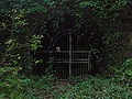
The curtain walls of the Walled Kitchen Garden with two roofless Gazebos or temples survive. One was used as a resting parlour
Parlour
Parlour , from the French word parloir, from parler , denotes an "audience chamber". In parts of the United Kingdom and the United States, parlours are common names for certain types of food service houses, restaurants or special service areas, such as tattoo parlors...
and the other was an aviary
Aviary
An aviary is a large enclosure for confining birds. Unlike cages, aviaries allow birds a larger living space where they can fly; hence, aviaries are also sometimes known as flight cages...
. They were both topped with statues as shown in surviving photographs. A handsome gate of cast-iron stood at the end of the bridge and its pilasters had two of the four statues representing the four seasons, the other two being on the temples. Loudon in 1824 comments the trees of the park are large, of picturesque form and much admired. The kitchen garden is one of the best in the country. The park trees were mainly beech, with oak and elm also present. An article in 1833 in the Gardeners' Magazine makes similar remarks and comments on the ... many hundred feet of hot houses; however, it also notes that the ... grounds are not kept up as they ought to be. A hedge maze
Maze
A maze is a tour puzzle in the form of a complex branching passage through which the solver must find a route. In everyday speech, both maze and labyrinth denote a complex and confusing series of pathways, but technically the maze is distinguished from the labyrinth, as the labyrinth has a single...
or labyrinth
Labyrinth
In Greek mythology, the Labyrinth was an elaborate structure designed and built by the legendary artificer Daedalus for King Minos of Crete at Knossos...
existed in the grounds up until the 1920s.
The Lugton Water was diverted in the 1790s to run behind the Garden Cottage, rather than in front of it. Five ponds were created by weirs. The gardens, amongst other things, possessed a peach house, an orangery, a vinery, a melon house and a mushroom house.
A large number of cottages, such as Fergushill, Higgins (on the old toll road), Millburn, Chapel Croft, Diamond, Gravel, Flush and Hill, and some miners rows existed at one time or other, together with place names such as Swine Park, Chapelholm, Knadgerhill, Irvine March wood, Meadow plantations and Long Drive; an area close to Eglinton Mains called 'The Circle', Crow and Old Woods, The Hill, also known locally as Foxes Lodge, etc., etc. Thomas and Anne Main once lived at The Hill cottage and their daughter Hetty was born there; they moved to Eglinton Mains farm. The 'Circle' was the large circle in the middle of a 'star burst' belvedere feature of the 1747 estate plantings. The area between Corsehillhead and Five Roads was known as 'Brotherswell'.
Captain Moreton's Eglinton Castle croquet
The earliest known reference to croquetCroquet
Croquet is a lawn game, played both as a recreational pastime and as a competitive sport. It involves hitting plastic or wooden balls with a mallet through hoops embedded into the grass playing court.-History:...
in Scotland is the booklet called The Game of Croquet, its Laws and Regulations which was published in the middle 1860’s for the proprietor of Eglinton Castle. On the page facing the title page is a picture of Eglinton Castle with a game of "croquet" in full swing.
A croquet lawn existed on the northern terrace, between the castle and the Lugton Water, also the old site of the marquee for the tournament banquet. The 13th Earl developed a variation on croquet named 'Captain Moreton's Eglinton Castle Croquet', which had small bells on the eight hoops 'to ring the changes', two pegs, a double hoop with a bell and two tunnels for the ball to pass through. In 1865 the 'Rules of the Eglinton Castle and Cassiobury Croquet' was published by Edmund Routledge. Several incomplete sets of this form of croquet are known to exist and one complete set is still used for demonstration games in the West of Scotland. It is not known why the earl named it thus.
Views of the old walled gardens and temples
The Baroque landscape feature
Benslie
Benslie is a small village in North Ayrshire, in the parish of Kilwinning, Scotland. Map reference NS 336 429.- History :This village, previously Benislay , Beinslay , Bainsley in 1821 , Bensley , Benslee or Benslee square on the 1860 OS map, Bendslee is situated next to Benslie wood...
hamlet and is shown on the 1750s Roy map. It lies outside the ornamental woodlands and has the 'appearance' of the foundations of a large building, although it was made up of trees. 55°39′0.8"N 4°38′37.7"W This odd shaped park or 'baroque park' feature has similarities to a 'Celtic' cross shape, a topographical feature mapped by Roy's surveyors. It may be a small deer hunting park or baroque
Baroque
The Baroque is a period and the style that used exaggerated motion and clear, easily interpreted detail to produce drama, tension, exuberance, and grandeur in sculpture, painting, literature, dance, and music...
garden layout possibly similar to one that existed at the Optagon Park, Alloa
Alloa
Alloa is a town and former burgh in Clackmannanshire, set in the Central Lowlands of Scotland. It lies on on the north bank of the Firth of Forth close to the foot of the Ochil Hills, east of Stirling and north of Falkirk....
Estate, Clackmannanshire; which in turn was after the Dutch taste and modelled on Hampton Court, the favourite home of King William
William III of England
William III & II was a sovereign Prince of Orange of the House of Orange-Nassau by birth. From 1672 he governed as Stadtholder William III of Orange over Holland, Zeeland, Utrecht, Guelders, and Overijssel of the Dutch Republic. From 1689 he reigned as William III over England and Ireland...
; a Dutchman. On the 1938 OS map the Montgreenan side of Benslie wood retains the shape of that part of the baroque garden. It is possible that this area was incomplete when mapped by Roy in the 1750s.
Listed structures in the park
The ruined castle is listed C (S) and the Rackets Hall is listed B. The Tournament Bridge by David Hamilton, which has lost its original Gothic parapet, is listed B. The offices and stables built around 1800 are also listed B; the stables are being converted into housing, but the office frontages have been preserved. Other listed buildings within the park are the Kilwinning Gates, B; the Doocot at the mains Farm, B; the Garden Cottage 1798, B; the walled kitchen gardens and the two derelict gazebos or temples, C (S); the Eglinton Park Bridge, B. The Ice House, Belvedere Gates, and the Mid Gates are no longer listed.The Stables, coach house and offices
The 1828 map marks this building as 'offices', however it clearly served the function of coach house and stables for coach horses as well. It was also known as Adam's Block. More stables were built in the 1890s for the farm carthorses.Some of the dressed stone blocks from which the old stables and offices are constructed have masons marks
Mason's mark
A mason's mark is a symbol often found on dressed stone in buildings and other public structures.-In stonemasonry:Scottish rules issued in 1598 stated that on admission to the guild, every mason had to enter his name and his mark in a register....
cut into them. This suggests that they were taken from the ruins of Kilwinning Abbey in 1792 when one of the Earls had the stables built on the site of a 16th-century cottage. Ness states that the stone came from a building called 'Easter Chaumers' which was part of the abbey. The design of the Montgomerie family crest above the entrance is identical to that on the castle ruins. The architect John Paterson built both, one being the 'trial piece' for the other. Kerelaw Castle
Kerelaw Castle
Kerelaw Castle is a castle ruin situated on the coast of North Ayrshire, Scotland in the town of Stevenston.- History :This castle, variously named Kerelaw, Kerila or even Turnlaw, is said by Timothy Pont to have been held by the Lockharts from Richard de Morville, Constable of Scotland, as far...
near Stevenston
Stevenston
Stevenston is a town in North Ayrshire, Scotland. It is one of the 'Three Towns' along with Ardrossan and Saltcoats.-History:The town is named after Stephan Loccard or Lockhart, whose father obtained a grant of land from Richard de Morville, Lord Cunninghame and Constable of Scotland, around 1170....
contained many carved stone coats of arms taken from the old abbey, which was clearly seen as being a convenient source of dressed or ornately carved stone for many a 'new' building in 'old' Cunninghame. The stables at Rozelle House in Ayr
Ayr
Ayr is a town and port situated on the Firth of Clyde in south-west Scotland. With a population of around 46,000, Ayr is the largest settlement in Ayrshire, of which it is the county town, and has held royal burgh status since 1205...
bear a more than passing resemblance to those at Eglinton.
Views of Eglinton Castle and the old offices / stables / factory
The carthorse stables, gas and electricity works
The old working horse stables, etc. have been converted into offices, a tea room, toilets, etc. A small Doocot is present in the courtyard. The old OSOrdnance Survey
Ordnance Survey , an executive agency and non-ministerial government department of the Government of the United Kingdom, is the national mapping agency for Great Britain, producing maps of Great Britain , and one of the world's largest producers of maps.The name reflects its creation together with...
maps show that by 1897 a gas works had been established here to supply the castle and offices. By 1911 this gas works had been replaced by an electricity power station in a new building which has been restored and is the present day park workshop.
The Rackets Hall
Rackets or RacquetsRacquets
Racquets may refer to:* The plural of Racquet, a piece of sporting equipment* Racquets , an indoor sport using long wooden racquets and a small, hard ball...
in American English, is an indoor sport played in the United Kingdom, United States, and Canada. The sport is infrequently called "hard rackets", to distinguish it from squash (formerly called "squash rackets"). Eglinton has a 'Racket Hall' which is first shown on the 1860 OS map, but was built shortly after 1839, the first match being recorded in 1846. The floor is of large granite slabs, now hidden by the wooden floor. It is the very first covered racquet court, built before the court size was standardised and is now the oldest surviving court in the World, as well as being the oldest indoor sports building in Scotland. It has been restored and converted into an exhibition area. In 1860 the earl employed a rackets professional, John Charles Mitchell (fourteen times champion) and Patrick Devitt replaced him. Mitchell owned a pub in Bristol with its own rackets court and this was named the "Eglinton Arms", having been the "Sea Horse" previously. As a player, Devitt once lost a £100 wager to a Mr Young.
Lady Jane's cottage ornee

Lady Jane Hamilton, the 13th Earl's Aunt built or extended 'Lady Jane's Cottage' which lay beside the Lugton Water. She used this thatched building to teach domestic economy to peasant girls. This may represent a later use of Lady Jane's cottage. Nothing now remains of this cottage, other than a 'crop' mark on aerial photographs, although the 1938 OS map still shows it. A persistent local tradition is that Lady Jane had in fact been banished to this cottage for some misdemeanour and was led back to the castle by a manservant every evening. It was a ruin by 1928.
A similar style of cottage existed on the Fullarton estate
Crosbie Castle and the Fullarton estate
Crosbie Castle and the Fullarton estate lie near Troon in South Ayrshire. The site was the home of the Fullartons of that Ilk for several centuries. Crosbie Castle eventually became an ice house after a new Fullarton House mansion was built. The mansion was demolished and the area set aside as a...
in Troon
Troon
Troon is a town in South Ayrshire. It is situated on the west coast of Scotland, about eight miles north of Ayr and three miles northwest of Glasgow Prestwick International Airport. Lying across the Firth of Clyde, the Isle of Arran can be seen. Troon is also a port with freight and ferry services...
as a lodge house near the Crosbie Kirk ruins. Lilliput Lane has produced a model of Lady Jane's cottage.
The gravestone to a faithful family pet dog, Toby, stood near Lady Jane's cottage and the ornamental pillar memorial; but has since been moved to the walled kitchen garden (See photograph). The inscription reads They take the good, Too good on Earth to stay; The bad was left, Too bad to take away. This dog's gravestone was originally in the Old Wood as recorded by Robin Cummell; Toby had belonged to the 10th Earl.
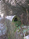
The Ice house
Icehouse (building)
Ice houses were buildings used to store ice throughout the year, prior to the invention of the refrigerator. Some were underground chambers, usually man-made, close to natural sources of winter ice such as freshwater lakes, but many were buildings with various types of insulation.During the...
lies in the Old Wood fairly near to the doocot on the Draught Burn, built by the 10th Earl for £25. 55°38′31.5"N 4°39′28.2"W It was not very successful and was later modified to increase its efficiency. It had a total of three doors to reduce the entrance of heat. It required extensive restoration and it is not known if the present structure accurately represents the original, other than that slates covered the exterior of the original structure. During the winter ice and snow was taken from the fishpond, etc. or even imported via Ardrossan
Ardrossan
Ardrossan is a town on the North Ayrshire coast in south-western Scotland. The name "Ardrossan" describes its physical position — 'ard' from the Gaelic àird meaning headland, 'ros' a promontory and the diminutive suffix '-an' - headland of the little promontory...
harbour if the winter had been too mild. A second ice house is recorded on the 1860 OS on the edge of the Ladyha park close to the bordering Weirston to Eglinton Kennels estate road; the design and location suggest that this was a venison larder.
To keep the ice frozen, doors or openings were usually built facing north and barley straw, reeds, fern fronds or sawdust was added between layers of ice or snow to act as insulation. Treated this way the ice would stay frozen for many months, or even a few years if a solution of ice and salt was added, and could be used to keep food fresh, make ice cream
Ice cream
Ice cream is a frozen dessert usually made from dairy products, such as milk and cream, and often combined with fruits or other ingredients and flavours. Most varieties contain sugar, although some are made with other sweeteners...
, sorbets, chilled drinks, syllabub
Syllabub
Syllabub is a traditional English dessert, popular from the sixteenth to the nineteenth century. It is usually made from rich milk or cream seasoned with sugar and lightly curdled with wine. Mrs Beeton gives two recipes...
s and so on consumed during the summer months and the ability to provide these exotic luxuries would raise the owner's social status. Ice could also be used to help keep food fresh in the kitchens or game larders during the summer months. The development of compressor driven refrigeration in the latter part of the 19th century rang the death knell for these structures. They were not used for the preservation of foodstuffs.
Rufford Abbey
Rufford Abbey is an estate in Sherwood Forest in Nottinghamshire, England. It was originally a Cistercian abbey. After the Dissolution of the Monasteries in the 16th century it became a country house...
in Sherwood Forest
Sherwood Forest
Sherwood Forest is a Royal Forest in Nottinghamshire, England, that is famous through its historical association with the legend of Robin Hood. Continuously forested since the end of the Ice Age, Sherwood Forest National Nature Reserve today encompasses 423 hectares surrounding the village of...
in Nottinghamshire
Nottinghamshire
Nottinghamshire is a county in the East Midlands of England, bordering South Yorkshire to the north-west, Lincolnshire to the east, Leicestershire to the south, and Derbyshire to the west...
, England had five ice houses! A drain at the bottom took meltwater away; ice houses were often built into earth banks to give extra insulation and to allow for the necessary drainage. As ice houses were mainly the reserve of large manor houses, there are not many good examples left in the UK and those that are found are usually in a state of disrepair.
Game larders
These were partly underground structures with stone foundations, used to store pheasants, rabbits, and other game, apart from venison. Ice was taken from the ice houses to the larders, which were placed conveniently beside the footpath to the laundry, as close to the castle kitchens as possible. Nothing remains today. An 1807 map clearly marks a game larder in this position.Deer Park ice-house
The Deer Park ice house lay close to the lane leading to Eglinton Kennels from the Tournament Bridge. It is marked as an Ice House on the 1911 OS map, its date, style of construction and position close to the deer park siggest that it was a place for preparing and storing venison from the deer park. Ice for this may have come from the nearby fishpond; emptied into the building via the two hatches in the roof. At this 'late' date in the history of the estate it may have been a commercial activity.This ice house was at some point converted into a cattle shelter by the opening up of one end of the building, the insertion of two air vents in the remaining end wall and the blocking up of the original side entrance. The ice-house may also have been partly uncovered and the brick roof coated with concrete. The building was demolished, circa 1990. 55°39′0.5"N 4°40′16.1"W
Image:Eglintonvenisonlarfer2.jpg|The old entrance and the demolished front wall.
Image:Eglinton venison larder castle end.jpg|The end facing the old castle; wall intact, but ventilation holes created.
Image:Eglinton venison larder interior.jpg|The interior, showing one of the 'skylights'.
Image:Eglinton venison larder interior of entrance.jpg|The interior view of the old entrance.
Views of the Doocots and Old Wood Ice house
Landscape features and miscellaneous views
Views of Eglinton's burns, ponds and bridges
The doocots
Gothic architecture
Gothic architecture is a style of architecture that flourished during the high and late medieval period. It evolved from Romanesque architecture and was succeeded by Renaissance architecture....
lectern style Doocot or dovecot (English spelling) is located near the scanty remains of the Eglinton Mains farm, situated on the B 7080 'Long Drive' towards Sourlie Hill interchange. 55°38′18.2"N 4°39′26.8"W It is said to have come from Kilwinning Abbey which was a possession of the Earls. However, the design is one from the 16th or 17th-centuries, the abbey having been dissolved in around 1560. The building suffered a fire and when rebuilt the crow steps and battlements may have been left out. Its style is in keeping with the 1802 castle, however the ornamental door carvings and the stones may have all come from the old abbey. The line of stone jutting out from the walls was a 'rat course' to keep these vermin out of the doocot. Ness categorically states that the dovecot was moved to its present position in 1898 - 1900 and was hopeful that it would be restored to the abbey grounds.
It was used to breed house doves and pigeons which the 15th Earl was particularly partial to. Doocots were not built to supply meat over the winter as the preferred bird was the young squab or squeakers, which were tender and fatty. A smaller doocot is built into the stable buildings overlooking the open courtyard. The larger doocot may have been built as a pheasantry, as it is not marked on OS maps as a doocot and old photographs do not show any internal nesting boxes. It does not appear until 1911 on OS
Ordnance Survey
Ordnance Survey , an executive agency and non-ministerial government department of the Government of the United Kingdom, is the national mapping agency for Great Britain, producing maps of Great Britain , and one of the world's largest producers of maps.The name reflects its creation together with...
maps and is located at the edge of a pheasantry enclosure. A second pheasantry was based at Gravel House according to the OS maps; a kennels was also being located there. Pheasantries were used for raising pheasants for field-sports on the old estate.
Doocots became so popular that by 1617 the right of owning one was limited by law to lairds who had lands producing at least ten chalders of victual, or about 10 tons. Doocots have even been said to have been one of the factors that lead to the French Revolution
French Revolution
The French Revolution , sometimes distinguished as the 'Great French Revolution' , was a period of radical social and political upheaval in France and Europe. The absolute monarchy that had ruled France for centuries collapsed in three years...
as the peasants had no choice but to watch their precious grain being taken by the landowners pigeons. Once turnips were grown and it became possible to over winter cattle, the need for pigeons as fresh meat in the winter therefore vanished and doocots fell out of use.
Curling ponds
Ordnance Survey
Ordnance Survey , an executive agency and non-ministerial government department of the Government of the United Kingdom, is the national mapping agency for Great Britain, producing maps of Great Britain , and one of the world's largest producers of maps.The name reflects its creation together with...
show that the estate had several curling
Curling
Curling is a sport in which players slide stones across a sheet of ice towards a target area. It is related to bowls, boule and shuffleboard. Two teams, each of four players, take turns sliding heavy, polished granite stones, also called "rocks", across the ice curling sheet towards the house, a...
ponds, one set of three at the Flushes near to Weirston House beside the A 737 Kilwinning Road and the other in between the Stanecastle and Girdle gates on the old Lochlibo Road. The Stanecastle pond had a tarred bottom, giving better quality ice that could also be used for stocking the ice house. The three separate ponds, are recorded by Historic Scotland and the OS map near Weirston House.
A contemporary watercolour (See gallery) shows a game being played at this site, called the Flushes. The Flushes Ponds were fed by the Bannoch Burn and a Curling House
Curling House
A Curling House was used to store curling stones, brushes and other equipment used to maintain a curling pond and play the game of curling in Scotland and elsewhere.- Introduction :...
was present, in which the traditional fare of pies and porter were provided for players, often followed by a night of entertainment at the castle.
Other curling ponds seem to have existed at the Kilwinning Road and on the opposite bank of the Draught Burn near the ice house in the Old Wood.
Curling can be a dangerous sport, for Paterson reports that in 1812 Captain Robert Montgomerie of Craighouse, Deputy-Lieutenant of the County of Ayr, died from a contusion of his foot acquired from a curling stone whilst playing at Eglinton castle!
Cricket ground and pavilion
From 1911 the OS maps show a cricket ground and a substantial pavilion built by the 16th Earl, the latter being parallel to the Lugton Water. Two English cricket professionals were employed to provide tuition and they lived in the 'Mid Gates' lodge (just off the main A 78 (T) entrance), which still survives. Neither the cricket ground nor the pavilion still exist, but part of the cricket ground area forms the site for caravaners, etc.Redburn House
This property was a dowerDower
Dower or morning gift was a provision accorded by law to a wife for her support in the event that she should survive her husband...
house of the estate, used to be situated opposite the Redburn gates. It had fine gardens with a summer house
Summer house
A summer house or summerhouse has traditionally referred to a building or shelter used for relaxation in warm weather. This would often take the form of a small, roofed building on the grounds of a larger one, but could also be built in a garden or park, often designed to provide cool shady places...
and a sundial; most likely the characteristic Scottish sundial
Scottish sundial
Scottish sundials of the renaissance period are not just more numerous than in any other country, they are also stylistically unique. This is particularly notable when the size and wealth of Scotland at the time are taken into account. They are free standing stone sculptures of the 17th and 18th...
type, although its present whereabouts are unknown. Redburn was also the base of the Estate Factor at one time. Archibald, the 17th Earl was born here. It was used as a hotel for a number of years before being demolished and the site developed as a housing estate.
The Cadgers' Racecourse
During each August, Irvine's Marymass Festival takes place as it has done for several centuries. Part of the celebrations are horse racing held on the Cadgers racecourse (a cadger was a person who transported goods on horseback in the days before carts were introduced) on the 'Towns Moor' which was part of the Eglinton estate. The course is clearly shown on a number of old maps, such as the 1775 map by Captain Armstrong, where it is called the 'Race Ground'. Later the Montgomeries purchased the Bogside area and built a new racecourse for thoroughbred horses, at which the Scottish Grand NationalScottish Grand National
The Scottish Grand National is a Grade 3 National Hunt steeplechase in Great Britain which is open to horses aged five years or older. It is run at Ayr, Scotland, over a distance of approximately 4 miles and 110 yards and 27 fences...
used to be held. The race moved to Ayr Racecourse
Ayr Racecourse
Ayr Racecourse at Whitletts Road, Ayr, Scotland, was opened on 1907. The track is a left-handed, oval track, thirteen furlongs in circumference, with a straight run-in of half a mile. There are courses for flat and for National Hunt racing...
in 1966 after the closure of Bogside Racecourse, where the race had been run over a distance of 3 miles 7 furlongs (6,236 m) since 1867. The 13th Earl brought steeplechasing to Scotland. His racing colours were his own tartan
Tartan
Tartan is a pattern consisting of criss-crossed horizontal and vertical bands in multiple colours. Tartans originated in woven wool, but now they are made in many other materials. Tartan is particularly associated with Scotland. Scottish kilts almost always have tartan patterns...
with yellow and his most successful horse, Flying Dutchman
The Flying Dutchman (horse)
The Flying Dutchman was an English Thoroughbred racehorse who all of his first two season's race starts and was also an influential sire.-Breeding:...
, won the Derby and the Saint Leger. The 13th Earl was not much interested in hunting, however he did take part in 'point to points' at Eglinton.
Eglinton's gates and gatehouses
The Eglintouns
Eglin, Lord of Eglintoun is the first of the family recorded, living during the reign of King Malcolm Canmore who is better known for his father being King Duncan, murdered by MacbethMacbeth
The Tragedy of Macbeth is a play by William Shakespeare about a regicide and its aftermath. It is Shakespeare's shortest tragedy and is believed to have been written sometime between 1603 and 1607...
of Shakespeare
William Shakespeare
William Shakespeare was an English poet and playwright, widely regarded as the greatest writer in the English language and the world's pre-eminent dramatist. He is often called England's national poet and the "Bard of Avon"...
fame. He may have been one of the Saxon
Anglo-Saxons
Anglo-Saxon is a term used by historians to designate the Germanic tribes who invaded and settled the south and east of Great Britain beginning in the early 5th century AD, and the period from their creation of the English nation to the Norman conquest. The Anglo-Saxon Era denotes the period of...
barons who accompanied Malcolm (who died in 1093) on his successful return to Scotland. The name is also recorded as Eglun of Eglunstone in 1205; a Saxon name.
The family continued to live at Eglinton until Elizabeth de Eglintoun, the sole heir, married Sir John de Montgomerie of Polnoon Castle
Polnoon Castle
Polnoon Castle was a 14th century fortification located on a motte beside the Polnoon Water in the Parish of Eaglesham, East Renfrewshire, Scotland.-The Montgomerys of Eaglesham:...
at Eaglesham
Eaglesham
Eaglesham , is a village and parish set in the west central Lowlands of Scotland - population 3,127 . Today it is chiefly a dormitory town for commuters to nearby Glasgow. The village is distinctive in being based around a large triangular green...
. Elizabeth's mother was Giles, daughter of Walter fitz Alan, Lord High Steward of Scotland, and sister of King Robert II
Robert II of Scotland
Robert II became King of Scots in 1371 as the first monarch of the House of Stewart. He was the son of Walter Stewart, hereditary High Steward of Scotland and of Marjorie Bruce, daughter of Robert I and of his first wife Isabella of Mar...
. When Hugh Eglintoun of that Ilk, her father, died soon after 1378 the Montgomerie family inherited the lands and hereafter Eglinton's history is bound up with that family.
The Earls of Eglinton and the Clan Montgomery
Earl of Glencairn
The title of Earl of Glencairn was created in the Peerage of Scotland in 1488 for the first Lord Kilmaurs .On the death of the fifteenth earl in 1796, there existing no original Letters Patent of the creation nor a given remainder in the various confirmations in title of previous earls the title...
, living in and around Stewarton
Stewarton
Stewarton is a town in East Ayrshire, Scotland. In comparison to the neighbouring towns of Kilmaurs, Fenwick, Dunlop and Lugton, it is a relatively large town, with a population of over 6,500. It is 300 feet above sea level.Groome, Francis H. . Ordnance Gazetteer of Scotland. Pub. Caxton. London....
and Kilmaurs
Kilmaurs
Kilmaurs is a village in East Ayrshire, Scotland. It lies on the Carmel, 21.1 miles south by west of Glasgow. Population recorded in 2001 Census, 2601- History :...
. In 1488 the Clan Montgomery burned down the Clan Cunningham's Kerelaw Castle. These two clans had a long feud, partly based on the rights of feudal superiority in old Cunninghame. In 1507 the 3rd Lord Eglinton was made the 1st Earl of Eglinton. During the 16th-century the long running feud continued between the Clan Montgomery and the Clan Cunningham. Eglinton Castle was burned down by the Cunninghams and then the Montgomery chief, the 4th Earl of Eglinton was ambushed and murdered by the Cunninghams at the Annick Water ford in Stewarton. The government of King James VI of Scotland eventually managed to get the rival chiefs to shake hands and keep the peace.
The family crest on the castle ruins and the old stables is said to represent a wife, Edgetta (Egidia?) or daughter of one the Earls holding a severed head, plus an anchor. She was reputedly kidnapped in the 1600s and taken to Horse Island
Horse Island
-Canada:*Horse Islands , Canada*Horse Island , Manitoba-Ireland:* SPA, 16 km north-west of Sligo town-Northern Ireland:*Horse Island, County Down, a townland in County Down, Northern Ireland...
off Ardrossan. Whilst on the island she developed the trust of her captor and promptly beheaded him. She was able to persuade her remaining captors to release her forthwith. Another version has a Danish Prince as an ardent admirer who abducted her, only for her to kill him and then persuade the crew of his ship to return her. A link may also exist with the popular biblical story of Holofermes, an Assyrian general of Nebuchadnezzar. The general laid siege to Bethulia, and the city almost surrendered. It was however saved by Judith, a beautiful Hebrew widow who entered Holofernes's camp, seduced, and then beheaded Holofernes while he was drunk. She returned to Bethulia with Holofernes head, and the Hebrews subsequently defeated the Assyrian army. Judith is considered as a symbol of liberty, virtue, and victory of the weak over the strong in a just cause. The anchor is seen as a symbol of good luck. Together these are good reasons for why the family adopted her as their crest.
Lady Jean Craufurd, daughter of the Earl of Craufurd, became Countess of Eglinton having narrowly survived death as a child, when her home, Kilbirnie House
Kilbirnie
Kilbirnie is a small town of 7280 inhabitants situated in North Ayrshire on the west coast of Scotland...
, burned down on 1 May 1757. On 29 July 1565 Queen Mary married Lord Darnley at Holyrood in Edinburgh. At the banquet held in the palace after the marriage the 2nd Earl of Eglinton waited upon Lord Darnley
Lord Darnley
Lord Darnley is a title associated with a Scottish Lordship of Parliament first created in 1356 and tracing a descent to the Dukedom of Richmond in England. Outside the Peerage of Scotland, another Earldom of Darnley was created in the Peerage of Ireland in 1729.The first baron was Sir John...
, together with the Earls of Cassillis and Glencairn.
The present earl is Archibald George Montgomerie, 18th Earl of Eglinton, and 6th Earl of Winton (b. 1939). The heir-Apparent is his son, Hugh Archibald William Montgomerie, Lord Montgomerie (b. 1966). Skelmorlie Castle
Skelmorlie Castle
Skelmorlie Castle is a castle in North Ayrshire, to the south of the village of Skelmorlie, on the Firth of Clyde, Scotland. The castle was formerly the seat and stronghold of the Montgomery Clan.-History:...
, near Largs
Largs
Largs is a town on the Firth of Clyde in North Ayrshire, Scotland, about from Glasgow. The original name means "the slopes" in Scottish Gaelic....
, was the seat of the earl, who is still chief of Clan Montgomery. In 1995 the family moved to Perthshire.
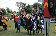
The Eglinton Tournament
Main Article Eglinton Tournament
Queen's Champion
The feudal holder of the Manor of Scrivelsby since 1066 has held that manor from the Crown by grand serjeanty of being The Honourable The King's/Queen's Champion. Such person is also Standard Bearer of England.- Origins :...
and his ritual challenge in full armour. This role would have fallen to the Knight Marshal
Knight Marshal
The Knight Marshal is a former office in the British Royal Household established by King Henry III in 1236. The position later became a Deputy to the Earl Marshal from the reign of Henry VIII until the office was abolished in 1846 ....
of the Royal Household, Sir Charles Lamb of Beaufort, the stepfather of the 13th Earl of Eglinton. The expense and extent of the preparations became news across Scotland, and the railway line was even opened in advance of its official opening to ferry guests to Eglinton. Although high summer, torrential rain washed the proceedings out. The tenantry of the Earl were provided with accommodation to view the proceedings. The participants, in full medieval dress or armour, gamely attempting to participate in events such as jousting, held at what is now the Eglinton Loch. Amongst the participants was the future Napoleon III of France.
Friends and admirers of the 13th Earl presented him with a magnificent silver commemorative 'trophy' designed by Edmund Cotterill, made in a medieval Gothic style by Messrs. Garrard of London at a cost of £1,775. This trophy is now kept in Cunninghame House, headquarters of North Ayrshire Council, having been gifted to the people of Ayrshire by the 14th Earl. A second silver trophy was presented by 300 citizens of Glasgow.
The damask from the pavilion of Lady Seymour, the Queen of Beauty, was used to make the curtains of the great drawing-room in the castle.
Amongst others, Benjamin Disraeli, Earl of Beaconsfield, described the tournament, 'weaving' it into in his romantic novel Endymion.
Within 100 years, Eglinton Castle and pleasure gardens were abandoned. The tournament, costing around £40,000, was a severe drain on the family fortune which, together with huge expenditure on the Ardrossan Harbour, the Glasgow, Paisley and Ardrossan Canal, and the Glasgow Bank failure, undermined the resources of a family who had been among the greatest landowning families of Ayrshire.
Tournament re-enactment
The decline and the rebirth of Eglinton

Skelmorlie Castle
Skelmorlie Castle is a castle in North Ayrshire, to the south of the village of Skelmorlie, on the Firth of Clyde, Scotland. The castle was formerly the seat and stronghold of the Montgomery Clan.-History:...
by December 1925.

Dunlop, East Ayrshire
Dunlop is a village and parish in East Ayrshire, Scotland. It lies on the A735, north-east of Stewarton, seven miles from Kilmarnock. The road runs on to Lugton and the B706 enters the village from Beith.-The village:...
for £24,000. The 17th Earl officiated at the opening of a food processing establishment in the old stables / offices. A large army vehicle storage facility was built in the estates Crow Wood area (this became Volvo Trucks) and the A 78 (T) with its interchanges and access roads cut through the southern section of the estate (mainly parts of the deer park and the Irvine March wood). Several housing schemes were to follow at Girdle Tool, Stanecastle, Knadgerhill, Sourlie, The Hill, etc.
The rebirth
The establishment of Eglinton Country Park by the old Irvine Development Corporation (IDC) and North Ayrshire Council saved much of the estate for the benefit of all the people of Ayrshire and beyond. Eglinton was designated as the 34th of 36 Country Parks in Scotland in 1986, officially opened by Professor Sir Robert Grieve and Kerry Anne Paterson. Mr. George Clark was the first Country Park Manager at Eglinton, now retired and succeeded by Mr. Cameron Sharp.The Wilson family had purchased the old offices, castle ruins, and other land from Robert Howie and Sons in 1950. Clement Wilson, the food processing factory owner, established the Clement Wilson Foundation (now known as the Barcapel Foundation Ltd.) which opened part of the grounds to the public, spending around £400,000 (around £4,317,000 in 2008 terms) on consolidating the castle ruins, planting trees, landscaping, making paths, creating a rockery and waterfall feature, restoring the Tournament Bridge, etc., etc. The waterfall no longer operates, but the waterfall feature and the large cistern that supplied the 'head of water' still exists at the bottom of the Belvedere in line with the old waterfall.
The gifting of the park by the Wilson family to Cunninghame District Council in 1978 made it possible to establish Eglinton Country Park, a resource which now attracts over 250,000 visitors a year.
The factory, which employed 300 people, closed in 1997, following the acquisition of its business;a claim is that the factory was closed in order for the new owners to obtain its order book.
Views of the old Eglinton stables and Auchenwinsey Farm
Image:Eglinton visitor centre prior to renovation.jpg|The old stables prior to conversion into the Tournament cafe
Image:Visitor centre 1980.jpg|The stables prior to redevelopment into the visitor centre
Image:Courtyard restoration.jpg|The courtyard undergoing initial restoration
Image:Diamond Bridge restoration.jpg|The Diamond Bridge undergoing restoration
Image:Ornate Lamp - Eglinton.jpg|An old ornate light on the stables
Image:Auchenwinsey Farm.JPG|Auchenwinsey old farm in 2008
Image:Sourlie Open Cast mine.jpg|The Sourlie Open Cast coal mine
Palaeontology
During the open-cast mining operations at Sourlie several sub-fossil antlers of ReindeerReindeer
The reindeer , also known as the caribou in North America, is a deer from the Arctic and Subarctic, including both resident and migratory populations. While overall widespread and numerous, some of its subspecies are rare and one has already gone extinct.Reindeer vary considerably in color and size...
and also bones of the Wooly Rhinoceros were found. Both of these species was hunted by early humans, who may have caused their extinction.
Scheduled and other structures
The Kilwinning Bridge and waggonway (B785 and Lugton River) and cropmarks of 3 circular enclosures (170m NNE of Eglinton Farm). Other noted features are the castle; cropmarks (NS317428); two cropmarks of circular enclosures (NS323426); and indeterminate cropmarks (NS314422).Prehistoric sites and finds
A small cordened cinerary urnUrn
An urn is a vase, ordinarily covered, that usually has a narrowed neck above a footed pedestal. "Knife urns" placed on pedestals flanking a dining-room sideboard were an English innovation for high-style dining rooms of the late 1760s...
or beaker was found with several other urns in a tumulus
Tumulus
A tumulus is a mound of earth and stones raised over a grave or graves. Tumuli are also known as barrows, burial mounds, Hügelgrab or kurgans, and can be found throughout much of the world. A tumulus composed largely or entirely of stones is usually referred to as a cairn...
very near to Eglinton Castle; it is now in the National Museum of Antiquities of Scotland. A search for the tumulus in the 1960s found that no traces remained. A greenstone axe-hammer was found at Eglinton between the stables and the offices by a Mr. John Palmer in the 19th-century. It is about 8 inches long and perforated near the blunt end. At Pytebog near Eglinton Kennels a stone axe was found in the 1890s. Near 'The Circle' close to old Eglinton Mains farm are the remains of a short cist
Cist
A cist from ) is a small stone-built coffin-like box or ossuary used to hold the bodies of the dead. Examples can be found across Europe and in the Middle East....
and aerial surveys show that the Belvidere Hill had a circular enclosure and ditch around its summit. Mesolithic
Mesolithic
The Mesolithic is an archaeological concept used to refer to certain groups of archaeological cultures defined as falling between the Paleolithic and the Neolithic....
flints and scrapers were found near North Millburn and in Chapelholm woods. A ritual site has been identified at 'The Circle' near the Drukken Steps
Drukken Steps
The Drukken or Drucken Steps were stepping stones across the Red Burn in Irvine, North Ayrshire, Scotland and are associated with Scotland's national poet, Robert Burns...
.
Lawthorn mount
A large and well preserved prehistoric cairnCairn
Cairn is a term used mainly in the English-speaking world for a man-made pile of stones. It comes from the or . Cairns are found all over the world in uplands, on moorland, on mountaintops, near waterways and on sea cliffs, and also in barren desert and tundra areas...
or barrow is present at Lawthorn. Its name is suggestive of a court hill
Moot hill
A moot hill or mons placiti is a hill or mound historically used as an assembly or meeting place. In early medieval Britain, such hills were used for "moots", meetings of local people to settle local business. Among other things, proclamations might be read; decisions might be taken; court cases...
or justice hill, which is indeed the oral tradition. It is 21 paces in diameter at the base, 14 feet (4.3 m) in diameter at the top and 9 in 8 in (2.95 m) high; largely composed of boulders and one large boulder of graywacke stone, 7 feet (2.1 m) long, is partially buried on the top edge facing south. An unofficial dig in the 20th-century revealed no finds. See the 'gallery' for a photograph.
Pre-reformation chapels
The foundations of the Stanecastle chapel were found a by Mr W Gray when digging drains. Judging from the foundations, the building must have been of considerable extent. Local tradition (J Fisher, Sevenacres) supports the findings, makes it more than probable that such a building once existed here. A chapel near Bourtreehill is mentioned by some sources. The 1858 OS map marks the site of a nearby cemetery and an intriguing subterranean passage or vault four feet below the surface; nothing is visible at the site today. A small village once existed here and one source has it that Stanecastle was once part of a nunnery before it became the home of the Francis family; eventually passing to the Montgomeries.
Industrial archaeology
Main Article Industry and the Eglinton Castle estateIndustry and the Eglinton Castle estate
The Eglinton Castle estate was situated at Irvine, on the outskirts of Kilwinning, North Ayrshire, Scotland in the former district of Cunninghame. Eglinton Castle, was once home to the Montgomeries, Earls of Eglinton and chiefs of the Clan Montgomery...
An unusually complex network of mineral railway lines, mainly running through the outer parts of the park, existed in the 19th and 20th centuries; the trackbed now being used as cycle paths in several places. A rare waggon-way bridge for the original 1.37 metre horse drawn railway (later relaid as standard gauge) still survives near South Fergushill farm on the B 785 Fergushill Road (see photograph), this being part of a 22 miles (35.4 km) long line running from Doura to Ardrossan. A very complex set of collieries, coal pits and fire-clay works are evident from records such as old maps. Very little remains (above ground at least!) of the buildings and railway lines, but odd depressions in the ground, old embankments, coal bings and abandoned bridges all bear witness to what was at one time a very active coalfield with associated businesses and infrastructure. Ladyha (previously Lady ha') Colliery's ruins survived until 2011 when they were deemed dangerous and were deomolished.
Hydraulic ram
A hydraulic ram, or hydram, is a cyclic water pump powered by hydropower. It functions as a hydraulic transformer that takes in water at one "hydraulic head" and flow-rate, and outputs water at a higher hydraulic-head and lower flow-rate...
and cistern in a bend of the Lugton Water close to one of the old Fergushill collieries. Hydraulic rams harnesses the flow or current force of water to pump a portion of the water being used to power the pump to a point higher than where the water originally started. Rams were often used in remote locations, since it requires no outside source of power other than the kinetic energy of falling water.
The existing workshops at the Visitor Centre were, as stated, the site of the electricity 'power station.' This supplied the castle and a number of the estate houses with a 110 volt electricity supply. A Mr. Dickie was the last manager of the power station.
Diamond was the name of a coalpit in the vicinity of Chapelholms which may explain the modern name 'Diamond Bridge' which is given to Chapelholms bridge and the name 'Diamond Lodge' which may have been the now demolished Chapel cottage. Black Diamond was a favourite horse of one of the Earls, but any connection is pure speculation.
Dykeshead farm, near the existing Tournament Interchange, was the site of an estate smithy.
Old railways around Eglinton
Image:Fergushillwaggonway1.JPG|The 19th-century waggonway bridge (foreground) over the Lugton Water near Fergushill farm. The two bridges were known as the 'Elbo and chael.'
Image:Corsehill old railway 1.JPG|A section of old railway trackbed at Corsehill looking towards the Bannoch Road
Image:Eglinton colliery loading dock eglinton.JPG|A loading dock onto an old siding at Benslie, on the closed and lifted Doura branchline
Lady Ha' colliery
Ladyha no 2 pit was sunk in 1885 to a depth of 568 feet (173.1 m) and closed in May 1934, having struggled since its main customer, the Eglinton Iron Company, closed in 1928. The Eglinton Iron Company had opened in 1845 and at one point covered 28 hectares (69.2 acre) with eight furnaces and a 100,000 ton iron production per year. A fairly substantial brick-lined tunnel still survives which once carried a standard gauge railway line unobtrusively to Ladyha colliery, out of the Earl's sight and the smoke kept away from the kitchen gardens' greenhouses and plants. Other such 'cosmetic' tunnels exist at Alloway and near Culzean Castle. The tunnel was used during World War II as a bomb shelter and remains in good condition. The various colliery buildings were demolished in 2011, some years after an attempt had been made by the Country Park authorities to develop an industrial archaeology trail through the site.
Scottish Wildlife Trust reserves
Three areas within the old boundaries of the old Eglinton estate have become nature reserves, first developed by Irvine Development Corporation (IDC), but now owned and managed by the Scottish Wildlife Trust with free and open access to the public. These reserves are within easy reach of the park. Sourlie woods is situated on the Sustrans cycle route and the A736 Glasgow Lochlibo Road runs next to it. Sourlie shows unmistakable signs of the areas intensive and complex industrial past in the shape of remains of old railway embankments from the London, Midland and Scottish RailwayLondon, Midland and Scottish Railway
The London Midland and Scottish Railway was a British railway company. It was formed on 1 January 1923 under the Railways Act of 1921, which required the grouping of over 120 separate railway companies into just four...
's Perceton branch to Perceton colliery, spoil heaps and other signs of coal and other workings.
| Etymology |
| The meaning of Corsehillmuir is 'Cross' with hill and 'Muir' meaning moorland. All the more ironic when it is recalled that witches and other criminals were burned at the stake here. |
Lawthorn woods (locally pronounced 'L'thorn' ) is a remnant of the Lawthorn plantation, which together with the 'Longwalk' and 'Stanecastle' plantations formed a much larger wooded area that once ran in an unbroken swathe down as far as Stanecastle and the old Stanecastle gate lodges. Lawthorn wood has easy access with a raised boardwalk running through it as a circular path. The other 'half' of the wood has long been reverted to pasture as old maps clearly show.
Corsehillmuir plantation is another woodland reserve in an area which was mainly open pasture and moorland prior to the 19th-century. It is situated off the B 785 between Mid Moncur and Bannoch farms. The historian John Smith records that this was the site of the ecclesiastical burning of witches and other criminals from the barony. The supposed witch Bessie Graham is said to have been burned at the stake at Corsehill Moor in 1649. It might have been the site of the old churchyard of Segdoune, the name of Kilwinning prior to the establishment of the abbey. The summits of the three low hills within the reserve are each surrounded by a circular ditch and dike, called 'Roundels' or 'hursts' (an embanked wood, formerly coppiced); the actual purpose of the ditch and dike is unknown, but the exclusion of cattle is the most likely explanation. Ness and others record that the 'Seggan' grew at Corsehillmuir, known also as the 'Messenger of the Gods', better known to us as the Yellow flag Iris.
Geocaches
There are several Geocaches within Eglinton park. You will need a GPS for this new sport. Visit www.geocaching.com for more informationSourlie, Lawthorn and Corsehillmuir nature reserves
Benslie and Fergushill
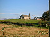
Scots language
Scots is the Germanic language variety spoken in Lowland Scotland and parts of Ulster . It is sometimes called Lowland Scots to distinguish it from Scottish Gaelic, the Celtic language variety spoken in most of the western Highlands and in the Hebrides.Since there are no universally accepted...
for an area manured by sheep, cattle or possibly deer. Fergushill church in Benslie was built to serve Montgreenan, Doura and Benslie. It was consecrated on Sunday, 3 November 1879 and the first minister was then Rev. William McAlpine. It got its name from the Fergushill Mission which was based at Fergushill school. The old school house is still in existence at the junction of the road to Seven Acres Mill. The manse is now a private house called Janburrow and stands at the entrance to the old Montgreenan railway station
Montgreenan railway station
Montgreenan railway station was a railway station near the village of Benslie, three miles north east of the town of Kilwinning, North Ayrshire, Scotland...
drive. Opposite is Burnbrae cottage, built as the Montgreenan Estate factor's house in 1846.
Fergushill church in Benslie was built to serve Fergushill, Doura and Benslie. It was consecrated on Sunday, 3 November 1879 and the first minister was then Rev. William McAlpine.
Fergushill Cottage faced the Lugton Water just below the point at which the Fergushill Burn joins the river. Nothing much remains, however a Mrs. Miller once lived here and she recollected collecting water from the well which still exists as a circular low brick wall near to the site.
Fergushill Tile Works existed in 1858, but is not shown on the 1897 OS map. A number of freight lines have run through the village, connecting the main line near Montgreenan with the Doura branch.
The area is named after the family of that name. Fergushill of that Ilk, the local laird, Robert de Fergushill de Eodem had an extensive estate here in 1417.
The Robbie Burns connection
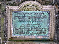
Another view is that the Drucken Steps were stepping stones on the course of the old Toll Road which ran from the west end of Irvine through the Eglinton policies to Kilwinning via Milnburn or Millburn; crossing the Redburn near Knadgerhill (previously Knadgarhill) and running past 'The Higgins' cottage, now demolished. The Higgins section is the only unaltered part where you can literally walk in the footsteps of Burns. The plaque on the commemorative cairn records that it was along this old toll road that Robert Burns and Richard Brown made their way to the woods of Eglinton.
The Scottish Campsite at Knadgerhill
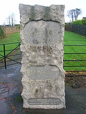
Edward I of England
Edward I , also known as Edward Longshanks and the Hammer of the Scots, was King of England from 1272 to 1307. The first son of Henry III, Edward was involved early in the political intrigues of his father's reign, which included an outright rebellion by the English barons...
sent a punitive expedition
Punitive expedition
A punitive expedition is a military journey undertaken to punish a state or any group of persons outside the borders of the punishing state. It is usually undertaken in response to perceived disobedient or morally wrong behavior, but may be also be a covered revenge...
under Sir Henry Percy to Irvine to quash an armed uprising against his dethronement of John Balliol. The Earl of Carrick, Robert Bruce and others led the Scottish army, however after much argument they decided to submit without a fight. The submission resulted in the signing of the 'Treaty of Irvine', supposedly at Seagate Castle
Seagate Castle
Seagate Castle is a castle in North Ayrshire, in the town of Irvine, close to the River Irvine, Scotland. The castle was formerly a stronghold, a town house, and later a dower house of the Montgomery Clan. The castle overlooks the oldest street in Irvine, which was once the main route between the...
in Irvine. The story became embellished with a purely fanciful involvement of William Wallace
William Wallace
Sir William Wallace was a Scottish knight and landowner who became one of the main leaders during the Wars of Scottish Independence....
in a brave action here. The memorial is therefore inaccurate and commemorates an event that might be best forgotten.
The Eglinton geocaches
As an encouragement to people to explore the park a number of geocaches have been put in place.The Eglinton Wildlife Site
The Scottish Wildlife Trust have designated part of the park as a 'Wildlife Site' through an agreement with the local council. The site is of 47 ha, with 6 ha of that being woodland. The map reference is NS 327 427, and the area covers Chapelholms Woods and the wetland associated with Eglinton Loch.The 1774 Irvine - Kilwinning Toll Road
Image:Eglinton Draughtburn Gate.JPG|Ruins at the Draughtburn Gate
Image:Draughtburn bridge toolroad.JPG|The course of the toll road from Draughtburn Bridge
Image:Millburn old bridge abutment.JPG|The old toll road brig at the Millburn
Image:Millburn old bridge approach.JPG|The approach to the old Millburn brig. The stone in the foreground on the left has a Benchmark
Benchmark (surveying)
The term bench mark, or benchmark, originates from the chiseled horizontal marks that surveyors made in stone structures, into which an angle-iron could be placed to form a "bench" for a leveling rod, thus ensuring that a leveling rod could be accurately repositioned in the same place in the future...
carved onto it.
The Drucken
Robert Burns and the Eglinton Estate
During the years 1781–1782, at the age of 23, Robert Burns lived in Irvine, North Ayrshire for a period of around 9 months, whilst learning the craft of flax-dressing from his mother's half-brother, Alexander Peacock, working at the heckling shop in the Glasgow Vennel...
or Drukken Steps were stepping stones on the course of the old Toll Road which ran from the west end of Irvine through the Eglinton policies to Kilwinning via Milnburn or Millburn; crossing the Redburn near Knadgerhill and running past 'The Higgins' cottage, which was occupied at one time by John Brown, gardener, and his wife Mary Ann. The Draughtburn Gate near Eglinton Mains was built to control or even prevent the movement of people along this old toll road. The course of the road can be followed until it is cut by the 'Long Drive' expressway.
Eglinton, Ireland
Eglinton in Northern Ireland was previously called Muff, however several places had this name, especially one in Donegal nearby, this caused so much confusion that the residents decided to change its name. Therefore on 19 August 1858 the village of Muff became 'Eglinton' in honour of the Lord Lieutenant of Ireland, Archibald, 13th Earl of Eglinton who was visiting Templemoyle Agricultural School at that time. An RAF Eglinton existed in Northern Ireland during the second World War and became the civilian Londonderry Eglinton Airport before being renamed City of Derry AirportCity of Derry Airport
City of Derry Airport is an airport located northeast of Derry, Northern Ireland. It is located on the south bank of Lough Foyle, a short distance from the village of Eglinton and from the city centre...
.
Micro history
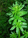
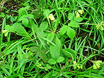
Like many other lairds the Montgomeries maintained a town house at Irvine, Seagate Castle.
A mountain and river in New Zealand were named 'Eglinton' after the 13th Earl of Eglinton.
The Glasgow, Paisley and Ardrossan Canal was never completed and the section from Paisley to Glasgow was converted into a railway. The Glasgow terminus had been known as Port Eglinton and the Caledonian Railway
Caledonian Railway
The Caledonian Railway was a major Scottish railway company. It was formed in the early 19th century and it was absorbed almost a century later into the London, Midland and Scottish Railway, in the 1923 railway grouping, by means of the Railways Act 1921...
station that replaced it was known as Eglinton Street Station.
Eglinton has been used as a Christian name, as in William Eglington Montgomerie of Annick Lodge
Annick Lodge and Greenville
Annick Lodge is an estate between Perceton and Cunninghamhead in North Ayrshire, Scotland.- History :Annick Lodge and estate was built by Captain Alexander Montgomery, the brother German of Hugh, Earl of Eglinton...
, who died 13 October 1884 age 84 yrs and is buried in Dreghorn cemetery.
A loch was planned in 1807, to be located where the existing loch is situated, but continuous with the river. An 'Eagle Well' existed in the Sourlie Burn plantation.
Dr. Duguid visited Bonshaw
Barony of Bonshaw
The Barony of Bonshaw, previously known as Bollingshaw, was in the old feudal Baillerie of Cunninghame, near Stewarton in what is now North Ayrshire, Scotland.-The Irvines and Boyds:...
, circa the 1840s and lists some of the items in the owners collection, including the stirrups from the horse that the 10th Earl of Eglinton was riding when he was shot and killed by gauger Mungo Campbell in 1769.
Persistent rumours exist of a ley tunnel
Ley tunnel
Ley tunnels are a common element of the local folklore tradition in the United Kingdom and they also occur in Europe. In Norwegian a ley tunnel-like passage is called a "lønngang" and in Swedish a "lönngång"...
which is said to from Kilwinning Abbey, under the 'Bean Yaird', below the 'Easter Chaumers' and the 'Leddy firs', and then underneath the Garnock and on to Eglinton Castle. No evidence exists for it, although the story may be related to the underground burial vault of the Montgomeries which does exist under the old abbey Another ley tunnel is said to run to Stanecastle.
Three ghosts are associated with the castle; a white lady; a grey lady and a ghost seen within the surviving castle tower in 1997.
A Charter of the time of Mary, Queen of Scots, refers to Eglinton's 'cunningaries' or rabbit-warrens.
The 'gem ring' on the Ardrossan Academy badge is taken from the Eglinton coat of arms; the Earl of Eglinton having been one of the founders of the school.
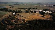
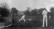
Eglinton Park (Toronto)
Eglinton Park is a public park located in the North Toronto neighbourhood of Toronto, Ontario, Canada, a few blocks west of the Eglinton Subway Station. It is bounded on the south end by Eglinton Avenue West, on the north by Roselawn Aveunue...
is a public park located in the North Toronto
North Toronto
North Toronto was a town located in the northern part of the Old Toronto district in Toronto, Ontario, Canada. It occupies a geographically central location within the current boundaries of the city of Toronto. It is a relatively narrow strip, centred around Yonge Street; it extends from the CP...
neighbourhood of Toronto, Ontario, Canada, just west of the Eglinton Subway Station
Eglinton (TTC)
Eglinton is a station on the Yonge–University–Spadina line of the subway system in Toronto, Ontario, Canada. It is at 2190 Yonge Street at Eglinton Avenue. It is one of the larger stations of the Toronto Transit Commission , with several shops located on the concourse level...
.
Knadgerhill was only acquired by the Earls of Eglinton in 1851 when they excambied
Excambion
-Definition:Excambion : The exchange of land. The deed whereby this is effected is termed "Contract of Excambion".There is an implied real warranty in this contract, so that if one portion is evicted or taken away on a superior title, the...
part of the lands of Bogside Flats for them. This allowed the construction of the new entrance to the policies at Stanecastle via Long Drive.
Eglinton castle is said by one of the gardeners to have had a room which was never opened. In about 1925 a young man from Kilwinning decided to take some of the panelling from a room in the castle as it was all being allowed to rot in the rain anyway, the roof had been removed. He went the castle to take away as much as he could carry, however one of the last pieces he selected left exposed the skeletal hand of a woman. The whole skeleton was later removed by a student doctor, but for fear of prosecution the matter was never reported to the police.
The commercial park near Irvine, situated in what was called the 'Crow Wood', has been named 'Tournament Park' and a 'castle' folly has been constructed on the nearby roundabout, commemorating the event. One of the main entrances to the castle, the Redburn gates, ran through this commercial park, however nothing now is left of the old ornamental gates and lodges that existed here, with just a portion of sandstone walling existing at the side of a layby. It is not known what happened to this sundial, but it may survive at another site.
A pet's grave, that of the dog Toby, the 10th Earl's pet, was located near Lady Jane's cottage, as was a marble memorial pillar to the 13th Earl's elder brother who died when he was six; the pillar being placed here because this was the site of the boys garden. This pillar is now located in the woods next to the Visitor centre. Parts of the sculpture that sat on top of this pillar were found at the 'new' site in 2007 by the North Ayrshire Rangers Service. The base of the pillar carries this inscription:
"To the memory of his beloved grandson, Hugh Who died the 13 July 1817 at the age of six years and a few months: A child of promise. On this spot once his little garden this stone is erected by his afflicted and disconsolate grandfather Hugh, Earl of Eglinton." |
The earl's dog was buried originally in the Old Wood by James Allen (a wright) with a young Robin Cummell at the scene and the earl giving him a sixpence with a gentle telling off for tresspassing.
The Barony Courthouse, owned by the Montgomeries, was situated opposite the old Abbey Green close to the Abbey grounds. It was demolished in 1970.
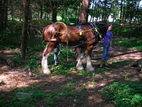
Kent
Kent is a county in southeast England, and is one of the home counties. It borders East Sussex, Surrey and Greater London and has a defined boundary with Essex in the middle of the Thames Estuary. The ceremonial county boundaries of Kent include the shire county of Kent and the unitary borough of...
.
The Redburn burn runs through the Eglinton estate from near Stanecastle and is named after the very high red iron salt content. It runs through the nearby 'Garnock Floods' Scottish Wildlife Trust nature reserve before flowing into the Garnock.
The Earls of Eglinton were keen hunters and the Eglinton Kennels (previously called Laigh Moncur) are situated off the B 785 Kilwinning to Benslie road.
Beside the Irvine New Town trail at the Old Wood is a large piece of machinery that appears to be of a military nature. This is actually a 'grubber' or 'rooter' which Robert Howie & Sons brought in to remove many of the old estate trees and create new pasture land. It was restored recently as part of a Countryside Ranger led project.
A boat house was present in 1828 beside the River Garnock, just below the old Redburn House on a loop of the river that was cut off and filled in as shown on the 25 inch OS map. The same map shows an area called 'Game Keppers' near Corsehill, the abode of estate Game keepers
Gamekeeper
A gamekeeper is a person who manages an area of countryside to make sure there is enough game for shooting, or fish for angling, and who actively manages areas of woodland, moorland, waterway or farmland for the benefit of game birds, deer, fish and wildlife in general.Typically, a gamekeeper is...
.
The small gates from Stanecastle were purchased and restored by Lord Robert Crichton-Stuart
John Crichton-Stuart, 4th Marquess of Bute
John Crichton-Stuart, 4th Marquess of Bute KT was a Scottish peer, the son of John Crichton-Stuart, 3rd Marquess of Bute....
circa 1970, husband of Lady Janet Montgomerie, daughter of Archibald Montgomerie, 16th Earl of Eglinton and Winton. Upon Lord Robert's death in 1976 they passed to a Mr. Simon Younger, in Haddington
Haddington, East Lothian
The Royal Burgh of Haddington is a town in East Lothian, Scotland. It is the main administrative, cultural and geographical centre for East Lothian, which was known officially as Haddingtonshire before 1921. It lies about east of Edinburgh. The name Haddington is Anglo-Saxon, dating from the 6th...
. The large gates were beyond 'economic' restoration.
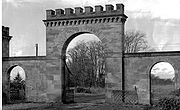
Gallows
A gallows is a frame, typically wooden, used for execution by hanging, or by means to torture before execution, as was used when being hanged, drawn and quartered...
, probably linked with the medieval right of 'Pit & gallows', held by the Lord of the Barony. This right was removed in 1747. In 1813, 31 unemployed men were given work levelling the Gallows Knowe at the muir prior to the construction of the new Academy. The wooden base of the gallows and several other associated finds were made.
In woodland near to the near the Doura Burn at North Millburn is a Glacial erratic
Glacial erratic
A glacial erratic is a piece of rock that differs from the size and type of rock native to the area in which it rests. "Erratics" take their name from the Latin word errare, and are carried by glacial ice, often over distances of hundreds of kilometres...
boulder. Such boulders were usually broken up by farmers and such a rare survival as this, is one more indicator that the site may be a genuine ancient woodland.
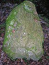
A piggery was built at the park before it was purchased by the local authority. A few of its buildings survive.
£100,000 was spent by the Montgomeries on creating Ardrossan's harbour and they intended to make it the principal port for Glasgow. Construction of the Glasgow, Paisley and Johnstone Canal
Glasgow, Paisley and Johnstone Canal
The Glasgow, Paisley and Ardrossan Canal was a canal in the west of Scotland, running between Glasgow, Paisley and Johnstone which later became a railway. Despite the name, the canal was never completed down to Ardrossan, the termini being Port Eglinton in Glasgow and Thorn Brae in Johnstone...
began in 1807 and the first boat, the passenger boat, The Countess of Eglinton, was launched in 1810; completion to Glasgow's Port Eglinton from Paisley was achieved in 1811, but the section to Ardrossan was never built. The Head gardener at Eglinton Castle laid out the policies and gardens at Spier's school, Beith in 1887.
HMS Eglinton was a World War II Hunt Class escort Destroyer built by Vickers Armstrong of Newcastle and launched on 28 December 1939. A previous HMS Eglinton was a World War I minesweeper; both were named after the Eglinton Foxhunt.
A Gauging station operated by SEPA is located just above the weir on the Lugton Water at the suspension bridge; it appears as a small building and a set of cables and wires stretched across the river.
Lady Frances Montgomerie was buried at Hollyrood Abbey in Edinburgh on 11 May 1797. She was the daughter of Archibald, 12th Earl of Eglinton.
At the coronation of Charles I at Holyrood the Earl of Eglinton had the honour of bearing the king's spurs.
Glasgow University's Eglinton Arts Fellowship was established in 1862 by subscription to commemorate the public services of Archibald William, 13th Earl of Eglinton, Rector of the University 1852-54.
See also
- Annick Lodge
- Barony and Castle of GiffenBarony and Castle of GiffenThe Barony of Giffen and its associated 15th-century castle were in the parish of Beith in the former District of Cunninghame, now North Ayrshire. The site may be spelled Giffen or Giffin and lay within the Lordship of Giffin, which included the Baronies of Giffen, Trearne, Hessilhead, Broadstone,...
A Montgomerie possession. - Bourtreehill houseBourtreehill HouseBourtreehill House and the enclosed land on which it was built form the original estate of Bourtreehill. The wooded hill-top, a distinctive feature of the estate, is now a landmark that sits at the centre of modern North Bourtreehill in the district of North Ayrshire on the west coast of...
- Clearance cairnClearance cairnA Clearance Cairn is an irregular and unstructured collection of fieldstones which have been removed from arable land or pasture to allow for more effective agriculture and collected into a usually low mound or cairn. Commonly of Bronze Age origins, these cairns may be part of a cairnfield where...
- Clyde Muirshiel Regional ParkClyde Muirshiel Regional ParkClyde Muirshiel Regional Park is the collective name for areas of countryside set aside for conservation and recreation on the South Clyde estuary in Scotland....
- Drukken StepsDrukken StepsThe Drukken or Drucken Steps were stepping stones across the Red Burn in Irvine, North Ayrshire, Scotland and are associated with Scotland's national poet, Robert Burns...
- Industry and the Eglinton Castle estateIndustry and the Eglinton Castle estateThe Eglinton Castle estate was situated at Irvine, on the outskirts of Kilwinning, North Ayrshire, Scotland in the former district of Cunninghame. Eglinton Castle, was once home to the Montgomeries, Earls of Eglinton and chiefs of the Clan Montgomery...
- Eglinton Tournament bridgeEglinton Tournament BridgeThe Eglinton Tournament Bridge is a bridge located within Eglinton Country Park near Kilwinning, North Ayrshire, Scotland. The bridge crosses the Lugton Water a short distance northwest of Eglinton Castle and was named after the Eglinton Tournament of 1839...
- Girdle TollGirdle TollGirdle Toll is a small village on the outskirts of Irvine, North Ayrshire.-Geography:It is situated off the Stanecastle Roundabout just next to the Stanecastle Keep. The village is from Prestwick Airport and only from the city of Glasgow....
- River IrvineRiver IrvineThe River Irvine is a river flowing through southwest Scotland, with its watershed on the Lanarkshire border of Ayrshire at an altitude of above sea-level, near Drumclog, and SW by W of Strathaven...
- Robert Burns and the Eglinton EstateRobert Burns and the Eglinton EstateDuring the years 1781–1782, at the age of 23, Robert Burns lived in Irvine, North Ayrshire for a period of around 9 months, whilst learning the craft of flax-dressing from his mother's half-brother, Alexander Peacock, working at the heckling shop in the Glasgow Vennel...
- Susanna Montgomery, Lady Eglinton
- Auchans, Ayrshire
External links
- Winton Estate Earls of Winton
- Horse riding at Eglinton
- The castle in Groomes Gazetteer for Scotland
- Scotways - for the preservation, defence, restoration and acquisition of public rights of access
- Sustrans National Cycle Network
- A Researcher's Guide to Local History terminology
- Historic Garden - Eglinton Castle.