
Eglinton Tournament Bridge
Encyclopedia
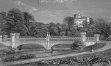
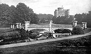
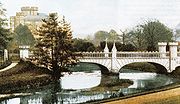
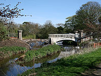
The Eglinton Tournament Bridge is a bridge
located within Eglinton Country Park
near Kilwinning
, North Ayrshire
, Scotland
. The bridge crosses the Lugton Water
a short distance northwest of Eglinton Castle
and was named after the Eglinton Tournament of 1839
. The castle and surrounding grounds were once home to the Montgomerie family, Earls of Eglinton
and chiefs of the Clan Montgomery
.
and the Eglinton Kennels, circa 1845. Archibald Montgomerie
, the 13th Earl of Eglinton
had the bridge built in a Gothic
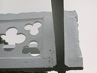
style, using cast iron for the arches, pinnacles, etc. and stone for the two pairs of miniature ornamental towers at either end. These towers have subtle design differences (See photographs) which are significant in the context of the extended history of the bridge. This 'Tournament' bridge is said to have been designed by the architect David Hamilton
; agreement to build the original three arched bridge was reached on 16 October 1799 by the 12th Earl of Eglinton and Hamilton's first recorded work dates from 1807. An Adam Russell is recorded as being partner to the agreement. The first bridge is described by Aiton in 1811 as A bridge of three arches, the piers of stone, and the arches of cast-iron, of the most elegant device, imitating the gothic style of the castle, with the family arms in the centre, now building about 100 yards below the castle, where the river is 102 feet broad ...
The bridge's cast iron parapet
is a repetition of the pointed Gothic arch design of the castle, surmounted by a battlement, and relieved in the centre with foliated pinnacle
s. The Tournament Bridge is B listed by Historic Scotland
.

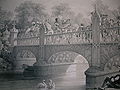
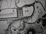
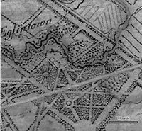
 The 1839 Eglinton Tournament was held on a meadow or holm at a loop in the Lugton Water. Most of the holm no longer exists, the excavations in this area having provided gravel and sand for the construction of the Kilwinning bypass and leaving behind an excavation pit which is now known as Eglinton Loch. The Knights on horseback and their retinue reached the tilt yard
('C' on the map) via an enclosed ride ('G' on the map), whilst the guests and visitors made their way to the stands via the route marked 'F' on the map illustrated. Both groups crossed over the previous three arched Gothic bridge. A map of 1837 of Eglinton Castle, Grounds and Tilt yard of 1837 shows that the tilt yard was already in existence at this early date, but it is not recorded what its fate was after the tournament was over.
 The 'new' Tournament Bridge served as a well used route across the Lugton Water, running through the Deer Park to Eglinton kennels (previously known as Laigh Moncur), especially on days when the Eglinton Hunt met at the castle itself. It was built by Messrs Connell of Dalgarven, using parts of the original bridge and possibly to a design by David Hamilton. Messrs. Connell also built the new Kilwinning Tower to a design by David Hamilton.
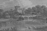 The original bridge, also with four pairs of miniature towers, but with three arches and four pinnacles, stood roughly 100 yards further up the river towards the castle; estate records show that it was built between 1802 and 1806 The original bridge is shown in several contemporary prints and maps as illustrated in the appropriate gallery of this article; the earliest is in William Aiton's book as published in 1811. It was this bridge that was used at the Eglinton Tournament as can be seen from the illustrations of the event, however the name was passed on to the 'new' bridge constructed downstream of it. No clear sign of this three arched bridge remains, a weir having been built at its old position; the 'old' bridge was constructed in 1811 according to Close., therefore around the time of the 'new' castle being built in 1801/2 and also when the grounds were being laid out by Tweedie.
Surviving architects drawings show the designs for a three arched bridge and as stated, contemporary prints of the Eglinton Tournament also show a three arched Tournament bridge, with cast iron arches, pinnacles and parapets which may have been re-used in the later 'new' bridge which survives today. David Hamilton is recorded on the 1811 engraving as being the architect.
The point at which the 'old' bridge crossed the Lugton was 102 feet broad and 100 yards downriver from the castle. It had the Montgomerie coat of arms in the centre. Aiton describes it as being under construction in 1811. The miniature castle towers on the demolished bridge are shown as each being surmounted by a double cross, but these do not figure on the 'new' Tournament Bridge; the 'old' bridge therefore may have been specially embellished for the tournament with temporary additions.
 A local minister, the Rev. Lee Ker, confirms which bridge was used at the tournament by relating in his book on Kilwinning
that the tournament procession passed over the Water of Lugton by what is now called the Tournament Bridge, but which was then situated about 100 yards nearer the Castle and had three arches instead of two. This distance coincides with a weir today and an old path from the castle leads directly to it. Dane Love states that the bridge used by the tournament had been built by the 12th Earl in 1811. In contemporary reports of the tournament no special mention of the bridge is made, suggesting that it was already a well established feature of the estate by that time and not an extravagant new feature specially built for the event.
Lauchlan confuses the issue by stating that an older bridge with three arches existed 100 yards up from the present one, however he states that the present bridge was built for the tournament. The old three arched bridge in fact still existed in 1840 and at least as late as 1843.
The Eglinton Bridge had what was probably light with oil lamps as can be seen in the 1811 engraving and the twin towers at either end were both joined by masonry work and not by cast iron work as in the present day two arched bridge. The Gothic embellishments on the engravings of the 1839 Tournament show that the oil lamps were removed for the event.
map of 1856 shows the two arched bridge in position, a weir at the position of the old bridge and by this time the old lake had gone, replaced by a canalised Lugton Water with several weirs.
Ironically the strengthening work done on the 'new' bridge to create an extra arch of bricks in addition to the cast iron, may have weakened the structure, contributing to its eventual partial collapse. The army used the bridge extensively with large lorries and even tanks crossing over it.
 The lower courses of ashlar on the bridge abutments and central pier were vermiculate. At some point the height of the weir beneath had been raised using an odd assortment of re-used stonework; this would have increased the depth and extent of the waters behind it. The central pier and the original weir had used reworked but re-cycled stone, probably from Kilwinning Abbey; as illustrated by a stone window surround recovered during restoration work (See illustration).
Examination of the top of the outer towers shows that something was attached to the centres, the 'plug' hole still being present. It is possible that the holes are related to the method of lifting them into position during construction work. The larger towers are capped with cement and nothing is therefore visible. During restoration work (2008) electricity power cables or possibly gas pipes were located leading to the bridge and they may have served some form of lighting on the bridge. These are not visible in the available illustrations. The Eglinton estate
had its own gasworks and later its own power station, so it would have been natural to provide lighting on the bridge. The old OS maps
show that by 1897 the gas works had been established here to supply the castle and offices, whilst by 1911 this had been replaced by an electricity works; the present day park workshop.
The larger and taller inner towers have been re-used from the older bridge, this being confirmed by the presence of ornate carving as infill within one of the larger towers. The curtain walls and the smaller and lower outer towers are made from a different type of stone and, as stated, the towers have a number of architectural differences, suggesting that they were made specifically for the 'new' Tournament Bridge (See photographs). During work on the central pier it was found that some of the hidden infill work is vermiculate ashlar from the 'old' bridge.
The cast iron sections of the arches are numbered and some of the sequence are absent, suggesting that these missing sections may have been damaged previously beyond repair and were not used therefore in the 'new' bridge.
and during this occupation the Tournament Bridge partly collapsed, partly due to alterations which had been made earlier by the Eglinton Estate, involving supposed strengthening using brickwork, as revealed during the 2008 restoration work. The old bridge partly collapsed in early 1936, the cast iron fascias and central pinnacles falling outwards.
To save the bridge from total collapse the 103rd (Glasgow) Company Royal Engineers
, who were encamped on the Irvine Moor, removed the cast iron outer fascia coverings and the pinnacles, encasing the remaining cast iron arches in concrete as can be seen from contemporary photographs and as further revealed during restoration work. It is not known what happened to the pinnacles and cast iron coverings. It had been thought that they were safely in storage, however enquiries have led to nothing. The soldiers in 1936 were at their annual camp and the repair section were commanded by Lieut R. J. P. Cowan and Sergeant David Borland.
 Originally the river would have been crossed by simple fords, however by the 18th century ornamental pleasure gardens had been formed and these were partly situated in what later became the deer park. No signs of these gardens are now visible, apart from Crop marks
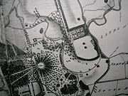
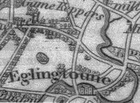
on aerial photographs taken around the end of the Second World War. A bridge was necessary to give access to the ornamental gardens and one is indicated on John Ainslie's map dated 1790, crossing the Lugton Water close to the castle itself. A small wooden bridge across the Lugton Water is shown in an illustration from around 1815, however this may not have been across the Lugton Water. Thomson's map of 1828 (See illustration) indicates a bridge crossing the Lugton Water at the castle where the three arched bridge was and a drive starting off at the position of the present day bridge, which may have been a ford at the time. Another bridge is suggested further upstream and close to the castle.
A wooden 'Laundry Bridge' stood close to the castle and downstream from it was second wooden bridge which was washed away in a storm in 1938. Local children used it to build rafts. An 1807 estate map shows a bridge cutting across to a larder and another bridge just downstream, linked to the network of formal paths.
 The restored Stables Bridge, also called Lady Jane's Bridge, lies on the Kilwinning Lodge drive and just downstream from it stood an elegant cast-iron bridge with a 50 foot span. This cast iron bridge had high quality stonework on both of the abutments, much of which survives. This bridge gave access to the kitchen walled gardens and glasshouse ranges and lasted into the mid 1940s when the army removed it.
The Suspension Bridge built by the army in the 1980s on behalf of the country park lies just below the weir beside the ruined gazebo. Lady Jane's cottage had a wooded pedestrian footbridge of which no sign remains.
The restored Diamond Bridge lies upstream near the Eglinton Loch and continues to give access to the old Toll Road from Irvine to Kilwinning via Fergushill
. This bridge was named after the nearby Black Diamond mine, the spoil heap or bing of which still remains rear the Chapelholm Gate. The colliery name in turn was associated with one of the 13th Earl's favourite horses, Black Diamond.
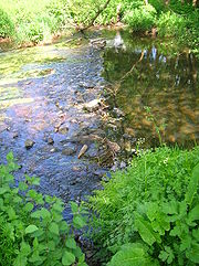 The Lugton Water
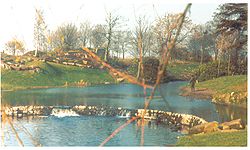
was diverted and altered several times, for example in the 1790s its course was altered by the 12th Earl (1740–1819) to run behind the Garden Cottage, rather than in front of it. The width was also changed at times, for instance five ponds or lakes were created by large weirs at one stage; the one at the Tournament Bridge is clearly visible in older prints of the 1840s (see illustrations) shown.
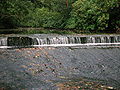
The size, shape and position of the various weirs was altered several times, latterly by Clement Wilson of the canning factory. One of the weirs lies directly beneath the restored Tournament Bridge. The one below the site of the old Bowling Green
and Robert Burns
's garden was 'U' shaped, holding back sufficient water at one time to form a lake with a small island bearing a single yew
tree. The 1938 OS
map shows no fewer than seven weirs between the castle and the present day Suspension Bridge.
 In 1948 the Trustees of the late 16th Earl sold most of the remaining parts of the estate to Robert Howie and Sons of Dunlop
for £24,000 and in the 1950s the Wilson family purchased the Tournament Bridge, old offices, castle ruins, and other land from Robert Howie and Sons.
Clement Wilson, the food processing factory owner, established the Clement Wilson Foundation which opened part of the grounds to the public, spending around £400,000 (around £4,317,000 in 2008 terms) on partially restoring the Tournament Bridge, consolidating the castle ruins, planting trees, landscaping, making paths, creating a rockery and waterfall feature, etc.
 The restoration of the Tournament Bridge involves a faithful and historic renovation of the 'Tournament Bridge', based on surviving documentary evidence. Historic Scotland
requires a ‘faithful restoration where all details are replicated as closely as possible in terms of material, design and construction’.
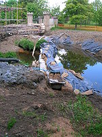
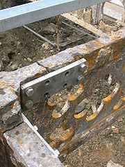 The concrete arches were removed as well as the infill above. The concrete arches were replaced with the existing refurbished cast iron arch sections and new cast iron fascia sections, which have restored the original width of the structure. The load-bearing capacity of the bridge is carried by a modern steel structure concealed beneath the wooden deck surface, as this was considered to be the original material, possibly coated with a layer of whin dust or such-like.
The timber parapets have been replaced with cast iron sections to match the original items. All of the cast iron elements have been fabricated and fitted by the Ballantine Bo'ness
Iron Company to restore the splendour of the original structure.
The restoration involved hydrodemolition
to expose the cast iron arches through removing the concrete in which they had been embedded. This process used very high pressure water jets and confirmed the poor structural integrity of the iron arches. They were not however intended to be load bearing in the restored bridge and an upside was the degree of Gothic artwork found to exist on the arches.
The estimated total project cost was £720k. Historic Scotland have indicated that they would be able to contribute some £161k, around £5k will be provided in kind, and the shortfall of £354k was the subject of the successful grant application to the Heritage Lottery Fund
. The final cost was in the order of a million pounds.
The bridge deck is made from imported hardwoods such as Ipe
. The bridge was re-opened on Friday, June 26, 2009.
Bridge
A bridge is a structure built to span physical obstacles such as a body of water, valley, or road, for the purpose of providing passage over the obstacle...
located within Eglinton Country Park
Eglinton Country Park
Eglinton Country Park is located in the grounds of the old Eglinton Castle estate, Kilwinning, North Ayrshire, Scotland . Eglinton Park is situated in the parish of Kilwinning, part of the former district of Cunninghame, and covers an area of 400 hectares...
near Kilwinning
Kilwinning
Kilwinning is a historic town in North Ayrshire, Scotland. It is known as The Crossroads of Ayrshire. The 2001 Census recorded it as having a population of 15,908.-History:...
, North Ayrshire
North Ayrshire
North Ayrshire is one of 32 council areas in Scotland with a population of roughly 136,000 people. It is located in the south-west region of Scotland, and borders the areas of Inverclyde to the north, Renfrewshire to the north-east and East Ayrshire and South Ayrshire to the East and South...
, Scotland
Scotland
Scotland is a country that is part of the United Kingdom. Occupying the northern third of the island of Great Britain, it shares a border with England to the south and is bounded by the North Sea to the east, the Atlantic Ocean to the north and west, and the North Channel and Irish Sea to the...
. The bridge crosses the Lugton Water
Lugton Water
The Lugton Water, the largest tributary of the River Garnock, runs from Loch Libo in Uplawmoor, through Lugton and the parishes of Neilston, Beith, Dunlop, Stewarton and Kilwinning...
a short distance northwest of Eglinton Castle
Eglinton Castle
Eglinton Castle was a large Gothic castellated mansion in Kilwinning, North Ayrshire, Scotland.-The castle :The ancient seat of the Earls of Eglinton, it is located just south of the town of Kilwinning...
and was named after the Eglinton Tournament of 1839
Eglinton Tournament of 1839
The Eglinton Tournament of 1839 was a re-enactment of a medieval joust and revel held in Scotland on Friday 30 August.It was funded and organized by Archibald Montgomerie, 13th Earl of Eglinton, and took place at Eglinton Castle, near Kilwinning in Scotland...
. The castle and surrounding grounds were once home to the Montgomerie family, Earls of Eglinton
Earl of Eglinton
Earl of Eglinton is a title in the Peerage of Scotland.Some authorities spell the title: Earl of Eglintoun In 1859 the thirteenth Earl of Eglinton, Archibald Montgomerie, was also created Earl of Winton in the Peerage of the United Kingdom, which gave him an automatic seat in the House of Lords,...
and chiefs of the Clan Montgomery
Clan Montgomery
-Origins of the Clan:Clan Montgomery originated in Wales, and emigrated to Scotland in the 12th century as vassals of the FitzAlans. The family derives its surname from lands in Wales, likely from the Honour of Montgomery which was located near the Shropshire lands of the FitzAlans...
.
The Tournament Bridges
The surviving 'Tournament Bridge' was built to provide an appropriate crossing point to gain access to the far side of the Lugton WaterLugton Water
The Lugton Water, the largest tributary of the River Garnock, runs from Loch Libo in Uplawmoor, through Lugton and the parishes of Neilston, Beith, Dunlop, Stewarton and Kilwinning...
and the Eglinton Kennels, circa 1845. Archibald Montgomerie
Archibald Montgomerie, 13th Earl of Eglinton
Sir Archibald William Montgomerie, 13th Earl of Eglinton KT, PC , known as Lord Montgomerie from 1814 to 1819, was a British Conservative politician...
, the 13th Earl of Eglinton
Earl of Eglinton
Earl of Eglinton is a title in the Peerage of Scotland.Some authorities spell the title: Earl of Eglintoun In 1859 the thirteenth Earl of Eglinton, Archibald Montgomerie, was also created Earl of Winton in the Peerage of the United Kingdom, which gave him an automatic seat in the House of Lords,...
had the bridge built in a Gothic
Gothic architecture
Gothic architecture is a style of architecture that flourished during the high and late medieval period. It evolved from Romanesque architecture and was succeeded by Renaissance architecture....
style, using cast iron for the arches, pinnacles, etc. and stone for the two pairs of miniature ornamental towers at either end. These towers have subtle design differences (See photographs) which are significant in the context of the extended history of the bridge. This 'Tournament' bridge is said to have been designed by the architect David Hamilton
David Hamilton (architect)
David Hamilton was a Scottish architect based in Glasgow. He has been called the "father of the profession" in Glasgow. Notable works include Hutchesons' Hall, Nelson Monument in Glasgow Green and Lennox Castle. The Royal Exchange in Queen Street is David Hamilton's best known building in Glasgow...
; agreement to build the original three arched bridge was reached on 16 October 1799 by the 12th Earl of Eglinton and Hamilton's first recorded work dates from 1807. An Adam Russell is recorded as being partner to the agreement. The first bridge is described by Aiton in 1811 as A bridge of three arches, the piers of stone, and the arches of cast-iron, of the most elegant device, imitating the gothic style of the castle, with the family arms in the centre, now building about 100 yards below the castle, where the river is 102 feet broad ...
The bridge's cast iron parapet
Parapet
A parapet is a wall-like barrier at the edge of a roof, terrace, balcony or other structure. Where extending above a roof, it may simply be the portion of an exterior wall that continues above the line of the roof surface, or may be a continuation of a vertical feature beneath the roof such as a...
is a repetition of the pointed Gothic arch design of the castle, surmounted by a battlement, and relieved in the centre with foliated pinnacle
Pinnacle
A pinnacle is an architectural ornament originally forming the cap or crown of a buttress or small turret, but afterwards used on parapets at the corners of towers and in many other situations. The pinnacle looks like a small spire...
s. The Tournament Bridge is B listed by Historic Scotland
Historic Scotland
Historic Scotland is an executive agency of the Scottish Government, responsible for historic monuments in Scotland.-Role:As its website states:...
.
Tiltyard
A tiltyard was an enclosed courtyard for jousting . Tiltyards were a common feature of late medieval castles and palaces...
('C' on the map) via an enclosed ride ('G' on the map), whilst the guests and visitors made their way to the stands via the route marked 'F' on the map illustrated. Both groups crossed over the previous three arched Gothic bridge. A map of 1837 of Eglinton Castle, Grounds and Tilt yard of 1837 shows that the tilt yard was already in existence at this early date, but it is not recorded what its fate was after the tournament was over.
Surviving architects drawings show the designs for a three arched bridge and as stated, contemporary prints of the Eglinton Tournament also show a three arched Tournament bridge, with cast iron arches, pinnacles and parapets which may have been re-used in the later 'new' bridge which survives today. David Hamilton is recorded on the 1811 engraving as being the architect.
The point at which the 'old' bridge crossed the Lugton was 102 feet broad and 100 yards downriver from the castle. It had the Montgomerie coat of arms in the centre. Aiton describes it as being under construction in 1811. The miniature castle towers on the demolished bridge are shown as each being surmounted by a double cross, but these do not figure on the 'new' Tournament Bridge; the 'old' bridge therefore may have been specially embellished for the tournament with temporary additions.
Kilwinning
Kilwinning is a historic town in North Ayrshire, Scotland. It is known as The Crossroads of Ayrshire. The 2001 Census recorded it as having a population of 15,908.-History:...
that the tournament procession passed over the Water of Lugton by what is now called the Tournament Bridge, but which was then situated about 100 yards nearer the Castle and had three arches instead of two. This distance coincides with a weir today and an old path from the castle leads directly to it. Dane Love states that the bridge used by the tournament had been built by the 12th Earl in 1811. In contemporary reports of the tournament no special mention of the bridge is made, suggesting that it was already a well established feature of the estate by that time and not an extravagant new feature specially built for the event.
Lauchlan confuses the issue by stating that an older bridge with three arches existed 100 yards up from the present one, however he states that the present bridge was built for the tournament. The old three arched bridge in fact still existed in 1840 and at least as late as 1843.
The Eglinton Bridge had what was probably light with oil lamps as can be seen in the 1811 engraving and the twin towers at either end were both joined by masonry work and not by cast iron work as in the present day two arched bridge. The Gothic embellishments on the engravings of the 1839 Tournament show that the oil lamps were removed for the event.
Construction of the 'new' Tournament Bridge
The new bridge may have been erected by the 13th Earl at some time between 1843 and 1856 as part of the total re-modelling of the course of the Lugton Water which had been first undertaken by the 12th Earl (1740–1819) and which included the alteration of its course, the removal of the lakes or ponds and the creation of several weirs. The Lugton Water is liable to severe floods and damage to the easily broken cast iron work by the force of the current, may have been a reason for its reconstruction at a different site; a severe 'Great Storm' in Ayrshire is recorded as having damaged or destroyed several buildings and structures in February 1856. The first Ordnance SurveyOrdnance Survey
Ordnance Survey , an executive agency and non-ministerial government department of the Government of the United Kingdom, is the national mapping agency for Great Britain, producing maps of Great Britain , and one of the world's largest producers of maps.The name reflects its creation together with...
map of 1856 shows the two arched bridge in position, a weir at the position of the old bridge and by this time the old lake had gone, replaced by a canalised Lugton Water with several weirs.
Ironically the strengthening work done on the 'new' bridge to create an extra arch of bricks in addition to the cast iron, may have weakened the structure, contributing to its eventual partial collapse. The army used the bridge extensively with large lorries and even tanks crossing over it.
Examination of the top of the outer towers shows that something was attached to the centres, the 'plug' hole still being present. It is possible that the holes are related to the method of lifting them into position during construction work. The larger towers are capped with cement and nothing is therefore visible. During restoration work (2008) electricity power cables or possibly gas pipes were located leading to the bridge and they may have served some form of lighting on the bridge. These are not visible in the available illustrations. The Eglinton estate
Eglinton Country Park
Eglinton Country Park is located in the grounds of the old Eglinton Castle estate, Kilwinning, North Ayrshire, Scotland . Eglinton Park is situated in the parish of Kilwinning, part of the former district of Cunninghame, and covers an area of 400 hectares...
had its own gasworks and later its own power station, so it would have been natural to provide lighting on the bridge. The old OS maps
Ordnance Survey
Ordnance Survey , an executive agency and non-ministerial government department of the Government of the United Kingdom, is the national mapping agency for Great Britain, producing maps of Great Britain , and one of the world's largest producers of maps.The name reflects its creation together with...
show that by 1897 the gas works had been established here to supply the castle and offices, whilst by 1911 this had been replaced by an electricity works; the present day park workshop.
The larger and taller inner towers have been re-used from the older bridge, this being confirmed by the presence of ornate carving as infill within one of the larger towers. The curtain walls and the smaller and lower outer towers are made from a different type of stone and, as stated, the towers have a number of architectural differences, suggesting that they were made specifically for the 'new' Tournament Bridge (See photographs). During work on the central pier it was found that some of the hidden infill work is vermiculate ashlar from the 'old' bridge.
The cast iron sections of the arches are numbered and some of the sequence are absent, suggesting that these missing sections may have been damaged previously beyond repair and were not used therefore in the 'new' bridge.
The Tournament Bridge and WWII
The Eglinton Castle Estate was requisitioned during World War IIWorld War II
World War II, or the Second World War , was a global conflict lasting from 1939 to 1945, involving most of the world's nations—including all of the great powers—eventually forming two opposing military alliances: the Allies and the Axis...
and during this occupation the Tournament Bridge partly collapsed, partly due to alterations which had been made earlier by the Eglinton Estate, involving supposed strengthening using brickwork, as revealed during the 2008 restoration work. The old bridge partly collapsed in early 1936, the cast iron fascias and central pinnacles falling outwards.
To save the bridge from total collapse the 103rd (Glasgow) Company Royal Engineers
Royal Engineers
The Corps of Royal Engineers, usually just called the Royal Engineers , and commonly known as the Sappers, is one of the corps of the British Army....
, who were encamped on the Irvine Moor, removed the cast iron outer fascia coverings and the pinnacles, encasing the remaining cast iron arches in concrete as can be seen from contemporary photographs and as further revealed during restoration work. It is not known what happened to the pinnacles and cast iron coverings. It had been thought that they were safely in storage, however enquiries have led to nothing. The soldiers in 1936 were at their annual camp and the repair section were commanded by Lieut R. J. P. Cowan and Sergeant David Borland.
Other estate bridges
Cropmark
Cropmarks or Crop marks are a means through which sub-surface archaeological, natural and recent features may be visible from the air or a vantage point on higher ground or a temporary platform...
on aerial photographs taken around the end of the Second World War. A bridge was necessary to give access to the ornamental gardens and one is indicated on John Ainslie's map dated 1790, crossing the Lugton Water close to the castle itself. A small wooden bridge across the Lugton Water is shown in an illustration from around 1815, however this may not have been across the Lugton Water. Thomson's map of 1828 (See illustration) indicates a bridge crossing the Lugton Water at the castle where the three arched bridge was and a drive starting off at the position of the present day bridge, which may have been a ford at the time. Another bridge is suggested further upstream and close to the castle.
A wooden 'Laundry Bridge' stood close to the castle and downstream from it was second wooden bridge which was washed away in a storm in 1938. Local children used it to build rafts. An 1807 estate map shows a bridge cutting across to a larder and another bridge just downstream, linked to the network of formal paths.
The Suspension Bridge built by the army in the 1980s on behalf of the country park lies just below the weir beside the ruined gazebo. Lady Jane's cottage had a wooded pedestrian footbridge of which no sign remains.
The restored Diamond Bridge lies upstream near the Eglinton Loch and continues to give access to the old Toll Road from Irvine to Kilwinning via Fergushill
Fergushill
Fergushill is a small community in North Ayrshire, Parish of Kilwinning, Scotland. The Barony of Fergushill was held by the Fergushill family of that Ilk and the area has a complex history.-The Fergushills of that Ilk:...
. This bridge was named after the nearby Black Diamond mine, the spoil heap or bing of which still remains rear the Chapelholm Gate. The colliery name in turn was associated with one of the 13th Earl's favourite horses, Black Diamond.
Lugton Water
River Irvine
The River Irvine is a river flowing through southwest Scotland, with its watershed on the Lanarkshire border of Ayrshire at an altitude of above sea-level, near Drumclog, and SW by W of Strathaven...
was diverted and altered several times, for example in the 1790s its course was altered by the 12th Earl (1740–1819) to run behind the Garden Cottage, rather than in front of it. The width was also changed at times, for instance five ponds or lakes were created by large weirs at one stage; the one at the Tournament Bridge is clearly visible in older prints of the 1840s (see illustrations) shown.
The size, shape and position of the various weirs was altered several times, latterly by Clement Wilson of the canning factory. One of the weirs lies directly beneath the restored Tournament Bridge. The one below the site of the old Bowling Green
Bowling green
A bowling green is a finely-laid, close-mown and rolled stretch of lawn for playing the game of lawn bowls.Before 1830, when Edwin Beard Budding invented the lawnmower, lawns were often kept cropped by grazing sheep on them...
and Robert Burns
Robert Burns
Robert Burns was a Scottish poet and a lyricist. He is widely regarded as the national poet of Scotland, and is celebrated worldwide...
's garden was 'U' shaped, holding back sufficient water at one time to form a lake with a small island bearing a single yew
Taxus
Taxus is a genus of yews, small coniferous trees or shrubs in the yew family Taxaceae. They are relatively slow-growing and can be very long-lived, and reach heights of 1-40 m, with trunk diameters of up to 4 m...
tree. The 1938 OS
Ordnance Survey
Ordnance Survey , an executive agency and non-ministerial government department of the Government of the United Kingdom, is the national mapping agency for Great Britain, producing maps of Great Britain , and one of the world's largest producers of maps.The name reflects its creation together with...
map shows no fewer than seven weirs between the castle and the present day Suspension Bridge.
The Clement Wilson gardens
Dunlop, East Ayrshire
Dunlop is a village and parish in East Ayrshire, Scotland. It lies on the A735, north-east of Stewarton, seven miles from Kilmarnock. The road runs on to Lugton and the B706 enters the village from Beith.-The village:...
for £24,000 and in the 1950s the Wilson family purchased the Tournament Bridge, old offices, castle ruins, and other land from Robert Howie and Sons.
Clement Wilson, the food processing factory owner, established the Clement Wilson Foundation which opened part of the grounds to the public, spending around £400,000 (around £4,317,000 in 2008 terms) on partially restoring the Tournament Bridge, consolidating the castle ruins, planting trees, landscaping, making paths, creating a rockery and waterfall feature, etc.
2008–9 restoration
Historic Scotland
Historic Scotland is an executive agency of the Scottish Government, responsible for historic monuments in Scotland.-Role:As its website states:...
requires a ‘faithful restoration where all details are replicated as closely as possible in terms of material, design and construction’.
The timber parapets have been replaced with cast iron sections to match the original items. All of the cast iron elements have been fabricated and fitted by the Ballantine Bo'ness
Bo'ness
Bo'ness, properly Borrowstounness, is a coastal town in the Central Lowlands of Scotland. It lies on a hillside on the south bank of the Firth of Forth within the Falkirk council area, north-west of Edinburgh and east of Falkirk. At the 2001 census, Bo'ness had a resident population of 13,961...
Iron Company to restore the splendour of the original structure.
The restoration involved hydrodemolition
Hydrodemolition
Hydrodemolition is a concrete removal technique which utilizes high-pressure water to remove deteriorated and sound concrete as well as asphalt and grout. This process provides an excellent bonding surface for repair material and new coating applications...
to expose the cast iron arches through removing the concrete in which they had been embedded. This process used very high pressure water jets and confirmed the poor structural integrity of the iron arches. They were not however intended to be load bearing in the restored bridge and an upside was the degree of Gothic artwork found to exist on the arches.
The estimated total project cost was £720k. Historic Scotland have indicated that they would be able to contribute some £161k, around £5k will be provided in kind, and the shortfall of £354k was the subject of the successful grant application to the Heritage Lottery Fund
Heritage Lottery Fund
The Heritage Lottery Fund is a fund established in the United Kingdom under the National Lottery etc. Act 1993. The Fund opened for applications in 1994. It uses money raised through the National Lottery to transform and sustain the UK’s heritage...
. The final cost was in the order of a million pounds.
The bridge deck is made from imported hardwoods such as Ipe
Tabebuia
Tabebuia is a neotropical genus of about 100 species in the tribe Tecomeae of the family Bignoniaceae. The species range from northern Mexico and southern Florida south to northern Argentina, including the Caribbean islands of Hispaniola and Cuba...
. The bridge was re-opened on Friday, June 26, 2009.