
Clyde Muirshiel Regional Park
Encyclopedia
Clyde Muirshiel Regional Park is the collective name for areas of countryside set aside for conservation and recreation on the South Clyde
estuary in Scotland
.
The Park covers an area of 108 square miles (279.7 km²) of Inverclyde
, North Ayrshire
and Renfrewshire
, stretching from Greenock
in the north, down the coast to Largs
and West Kilbride
and inland to Dalry
and Lochwinnoch
.
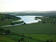
It consists of Castle Semple Loch
and Collegiate Church, The Greenock Cut Centre (formerly Cornalees Bridge), Muirshiel Country Park, Barnbrock Farm, Lunderston Bay, Locherwood, Haylie Brae and Knockendon.
proposed the Renfrewshire Regional Park and implemented a programme to manage an area of 30000 acres (121.4 km²) including the creation of Muirshiel Country Park in June 1970. Castle Semple Water Park followed in 1971 and the Cornalees Bridge Visitor Centre opened in 1973. Responsibility for the parks was taken over by Strathclyde Regional Council in 1975 before the Clyde Muirshiel Park Authority came into existence in 1990. Today the Authority's committee comprises councillors from the three local authorities as well as Scottish Natural Heritage
.
 Two Country Parks with visitors centres are located within the regional park at Castle Semple
and Muirshiel, together with a separate visitors centre at Cornalees
.
An outdoor activity centre and boat and bike hire facilities are based at Castle Semple.
Barnbrock hosts a campsite, community woodlands are to be found at Locherwoods and Outerwards and a sandy beach is at Lunderston Bay
. The Greenock cut
and the Collegiate church will interest the historians and there are numerous other sites, such as the Haylie Brae, with car parking for visitors to enjoy picnics, good views, wildlife, walks and cycles.
as well as land based activities such as archery, mountain biking, hill walking, orienteering, navigation and first aid.
Lochwinnoch
Loop Line cycle track runs through the Castle Semple Loch visitors centre. It is 14 miles (22.5 km) long and is part of the Lochs and Glens Route. It follows the National Cycle Route 75 from Paisley Canal Railway Station to Johnstone
and then heads southwest to Kilbarchan
, Lochwinnoch and Kilbirnie passing Castle Semple, Barr and Kilbirnie
Lochs. Being mainly built on an old railway line it has easy gradients and is mostly traffic free.
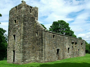
 This Church was founded and endowed ; it stands near where the original Sempill Castle once stood. Castle Semple was a Collegiate church
, which means that it was administered and served by a college of canons or prebendaries
, presided over by a dean or provost. Collegiate churches were often supported by lands held by the church, endowed here in 1504 by John, 1st Lord Sempill
. The church is built in a late Gothic style with a rectangular body and square tower at the west end and a three sided apse at the east end. The Church is in the care of Historic Scotland
.
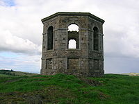 The small temple
building or folly
on the Kenmure Hill knoll to the northern end of Castle Semple loch is one of the few remains of the Castle Semple estate. Col. William MacDowell was responsible for the 'Temple' and also for building of Castle Semple House, which was destroyed by fire in 1935. All that remains of this 900 acres (3.6 km²) estate is the folly, a walled garden and a pair of gate arches.
 A freshwater lake known as Shaws Water used to exist at a level high above Greenock until the civil engineer Robert Thom prepared a scheme to turn this into a reservoir, subsequently named after him as Loch Thom
. He also created the aqueduct
which became known as "The Cut", the whole scheme officially opening on 16 April 1827. The aqueduct supplied both a dependable flow and a good quality of water to the town for both domestic and business purposes.
Leaving Loch Thom at Cornalees, The Cut , with its footpath, runs westward and then turns northward as it follows the contour of Dunrod Hill which it follows round until running directly above the town of Greenock
at Overton
, having come a distance of 5.5 miles (8.9 km) or 9 km. It collects some of the water from streams that cross its path, and a series of sluice gates incorporate an ingenious automatic way of releasing surplus water.
of shipbuilding fame. The project was undertaken to keep men employed after a drop in ship orders following World War 1. The line was used to take grouse shooting parties into the hills. It is thought to have closed in the late 1970s and is now derelict. The engine shed is still present, as are parts of the station platform and the rails are still in situ, most however are buried in the peat.
The Grouse Railway lies 3 miles (5 km) west southwest of Kilmacolm. With its multiple branches following the contours of the hills, the railway was designed to convey their shooting parties around the grouse moor. Completed around 1922 and extending to 7 miles (11 km), the railway used materials salvaged from old warships. Two 20 hp wheelled 2 ft (0.6096 m) gauge petrol-driven locomotives were purchased in 1922 from the Motor Rail
& Tramcar Company of Bedford - Works Numbers 2097 and 2171. The Company had already equipped a similar 'grouse railway' in 1920 for Sir Archie Birkmyre of Dalmunzie near Glenshee. In September 1969 a further 4 wheeled 20/28 HP dioesel locomotive (Works No 8700 of 1941) was purchased second hand from Joseph Arnold Ltd's sand quarriesy in Leighton Buzzard. King Edward VIII was amongst guests to make use of the railway.
River Clyde
The River Clyde is a major river in Scotland. It is the ninth longest river in the United Kingdom, and the third longest in Scotland. Flowing through the major city of Glasgow, it was an important river for shipbuilding and trade in the British Empire....
estuary in Scotland
Scotland
Scotland is a country that is part of the United Kingdom. Occupying the northern third of the island of Great Britain, it shares a border with England to the south and is bounded by the North Sea to the east, the Atlantic Ocean to the north and west, and the North Channel and Irish Sea to the...
.
The Park covers an area of 108 square miles (279.7 km²) of Inverclyde
Inverclyde
Inverclyde is one of 32 council areas used for local government in Scotland. Together with the Renfrewshire and East Renfrewshire council areas, Inverclyde forms part of the historic county of Renfrewshire - which current exists as a registration county and lieutenancy area - located in the west...
, North Ayrshire
North Ayrshire
North Ayrshire is one of 32 council areas in Scotland with a population of roughly 136,000 people. It is located in the south-west region of Scotland, and borders the areas of Inverclyde to the north, Renfrewshire to the north-east and East Ayrshire and South Ayrshire to the East and South...
and Renfrewshire
Renfrewshire
Renfrewshire is one of 32 council areas used for local government in Scotland. Located in the west central Lowlands, it is one of three council areas contained within the boundaries of the historic county of Renfrewshire, the others being Inverclyde to the west and East Renfrewshire to the east...
, stretching from Greenock
Greenock
Greenock is a town and administrative centre in the Inverclyde council area in United Kingdom, and a former burgh within the historic county of Renfrewshire, located in the west central Lowlands of Scotland...
in the north, down the coast to Largs
Largs
Largs is a town on the Firth of Clyde in North Ayrshire, Scotland, about from Glasgow. The original name means "the slopes" in Scottish Gaelic....
and West Kilbride
West Kilbride
West Kilbride is a village in North Ayrshire, on the west coast of Scotland by the Firth of Clyde, looking across the water to Goat Fell and the Isle of Arran...
and inland to Dalry
Dalry, North Ayrshire
Dalry is a small town in the Garnock Valley in Ayrshire, Scotland.-History:Dalry means "King's Valley" or more simply the "Rye Meadow"; indicating a small settlement on the Rye Burn. Its history has signs of early inhabitants in the area...
and Lochwinnoch
Lochwinnoch
Lochwinnoch is a village in the council area and historic county of Renfrewshire in the west central Lowlands of Scotland. Lying on the banks of Castle Semple Loch and the River Calder, Lochwinnoch is chiefly a residential dormitory village serving nearby urban centres such as Glasgow and Paisley...
.
It consists of Castle Semple Loch
Castle Semple Loch
Castle Semple Loch is a 1.5 mile long inland loch at Lochwinnoch in Renfrewshire, Scotland. Originally part of an estate of the same name, it is now administered by Clyde Muirshiel Regional Park as a watersports centre...
and Collegiate Church, The Greenock Cut Centre (formerly Cornalees Bridge), Muirshiel Country Park, Barnbrock Farm, Lunderston Bay, Locherwood, Haylie Brae and Knockendon.
Origins
A Regional Park designation for the area was first proposed in 1947. However it was 20 years later that Renfrewshire County CouncilRenfrewshire (historic)
Renfrewshire or the County of Renfrew is a registration county, the Lieutenancy area of the Lord Lieutenant of Renfrewshire, and one of the counties of Scotland used for local government until 1975. Renfrewshire is located in the West Central Lowlands of Scotland, south of the River Clyde,...
proposed the Renfrewshire Regional Park and implemented a programme to manage an area of 30000 acres (121.4 km²) including the creation of Muirshiel Country Park in June 1970. Castle Semple Water Park followed in 1971 and the Cornalees Bridge Visitor Centre opened in 1973. Responsibility for the parks was taken over by Strathclyde Regional Council in 1975 before the Clyde Muirshiel Park Authority came into existence in 1990. Today the Authority's committee comprises councillors from the three local authorities as well as Scottish Natural Heritage
Scottish Natural Heritage
Scottish Natural Heritage is a Scottish public body. It is responsible for Scotland's natural heritage, especially its natural, genetic and scenic diversity. It advises the Scottish Government and acts as a government agent in the delivery of conservation designations, i.e...
.
Facilities within the park
Castle Semple Loch
Castle Semple Loch is a 1.5 mile long inland loch at Lochwinnoch in Renfrewshire, Scotland. Originally part of an estate of the same name, it is now administered by Clyde Muirshiel Regional Park as a watersports centre...
and Muirshiel, together with a separate visitors centre at Cornalees
Loch Thom
Loch Thom is a reservoir which since 1827 has provided a water supply to the town of Greenock in Inverclyde, Scotland. It is named after the civil engineer Robert Thom who designed the scheme which created the reservoir and delivered water via a long aqueduct known as The Cut...
.
An outdoor activity centre and boat and bike hire facilities are based at Castle Semple.
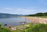
Barnbrock hosts a campsite, community woodlands are to be found at Locherwoods and Outerwards and a sandy beach is at Lunderston Bay
Lunderston Bay
Lunderston Bay on the east coast of the Firth of Clyde provides a popular beach and picnic area and is part of Clyde Muirshiel Regional Park. It lies in Inverclyde to the south of Gourock and gives access to a coastal walk continuing further south to Inverkip....
. The Greenock cut
Loch Thom
Loch Thom is a reservoir which since 1827 has provided a water supply to the town of Greenock in Inverclyde, Scotland. It is named after the civil engineer Robert Thom who designed the scheme which created the reservoir and delivered water via a long aqueduct known as The Cut...
and the Collegiate church will interest the historians and there are numerous other sites, such as the Haylie Brae, with car parking for visitors to enjoy picnics, good views, wildlife, walks and cycles.
Activities
Clyde Muirshiel offers year round instructor led activities include sailing, kayaking, canoeing and raft building on the shallow inland Castle Semple LochCastle Semple Loch
Castle Semple Loch is a 1.5 mile long inland loch at Lochwinnoch in Renfrewshire, Scotland. Originally part of an estate of the same name, it is now administered by Clyde Muirshiel Regional Park as a watersports centre...
as well as land based activities such as archery, mountain biking, hill walking, orienteering, navigation and first aid.
The Sustrans Cycle track
The SustransSustrans
Sustrans is a British charity to promote sustainable transport. The charity is currently working on a number of practical projects to encourage people to walk, cycle and use public transport, to give people the choice of "travelling in ways that benefit their health and the environment"...
Lochwinnoch
Lochwinnoch
Lochwinnoch is a village in the council area and historic county of Renfrewshire in the west central Lowlands of Scotland. Lying on the banks of Castle Semple Loch and the River Calder, Lochwinnoch is chiefly a residential dormitory village serving nearby urban centres such as Glasgow and Paisley...
Loop Line cycle track runs through the Castle Semple Loch visitors centre. It is 14 miles (22.5 km) long and is part of the Lochs and Glens Route. It follows the National Cycle Route 75 from Paisley Canal Railway Station to Johnstone
Johnstone
Johnstone is a town in the council area of Renfrewshire and larger historic county of the same name in the west central Lowlands of Scotland.The town lies three miles west of neighbouring Paisley and twelve miles west of the centre of the city of Glasgow...
and then heads southwest to Kilbarchan
Kilbarchan
Kilbarchan is a village and civil parish in central Renfrewshire, in the west central Lowlands of Scotland. The village's name means "cell of St. Barchan". It is known for its former weaving industry.- History :...
, Lochwinnoch and Kilbirnie passing Castle Semple, Barr and Kilbirnie
Kilbirnie
Kilbirnie is a small town of 7280 inhabitants situated in North Ayrshire on the west coast of Scotland...
Lochs. Being mainly built on an old railway line it has easy gradients and is mostly traffic free.
The Castle Semple Collegiate church
Collegiate church
In Christianity, a collegiate church is a church where the daily office of worship is maintained by a college of canons; a non-monastic, or "secular" community of clergy, organised as a self-governing corporate body, which may be presided over by a dean or provost...
, which means that it was administered and served by a college of canons or prebendaries
Prebendary
A prebendary is a post connected to an Anglican or Catholic cathedral or collegiate church and is a type of canon. Prebendaries have a role in the administration of the cathedral...
, presided over by a dean or provost. Collegiate churches were often supported by lands held by the church, endowed here in 1504 by John, 1st Lord Sempill
Lord Sempill
Lord Sempill is a title in the Peerage of Scotland. It was created in circa 1489 for Sir John Sempill, founder of the collegiate Church of Lochwinnoch. Sempill was killed at the Battle of Flodden in 1513. His grandson, the third Lord, was known as "The Great Lord Sempill"...
. The church is built in a late Gothic style with a rectangular body and square tower at the west end and a three sided apse at the east end. The Church is in the care of Historic Scotland
Historic Scotland
Historic Scotland is an executive agency of the Scottish Government, responsible for historic monuments in Scotland.-Role:As its website states:...
.
The Castle Semple Temple
Temple
A temple is a structure reserved for religious or spiritual activities, such as prayer and sacrifice, or analogous rites. A templum constituted a sacred precinct as defined by a priest, or augur. It has the same root as the word "template," a plan in preparation of the building that was marked out...
building or folly
Folly
In architecture, a folly is a building constructed primarily for decoration, but either suggesting by its appearance some other purpose, or merely so extravagant that it transcends the normal range of garden ornaments or other class of building to which it belongs...
on the Kenmure Hill knoll to the northern end of Castle Semple loch is one of the few remains of the Castle Semple estate. Col. William MacDowell was responsible for the 'Temple' and also for building of Castle Semple House, which was destroyed by fire in 1935. All that remains of this 900 acres (3.6 km²) estate is the folly, a walled garden and a pair of gate arches.
Loch Thom and the Greenock cut
Loch Thom
Loch Thom is a reservoir which since 1827 has provided a water supply to the town of Greenock in Inverclyde, Scotland. It is named after the civil engineer Robert Thom who designed the scheme which created the reservoir and delivered water via a long aqueduct known as The Cut...
. He also created the aqueduct
Aqueduct
An aqueduct is a water supply or navigable channel constructed to convey water. In modern engineering, the term is used for any system of pipes, ditches, canals, tunnels, and other structures used for this purpose....
which became known as "The Cut", the whole scheme officially opening on 16 April 1827. The aqueduct supplied both a dependable flow and a good quality of water to the town for both domestic and business purposes.
Leaving Loch Thom at Cornalees, The Cut , with its footpath, runs westward and then turns northward as it follows the contour of Dunrod Hill which it follows round until running directly above the town of Greenock
Greenock
Greenock is a town and administrative centre in the Inverclyde council area in United Kingdom, and a former burgh within the historic county of Renfrewshire, located in the west central Lowlands of Scotland...
at Overton
Overton, Greenock
Overton is an area in the suburbs of Greenock, Inverclyde. Overton offers excellent views across the River Clyde and suburban Greenock.The area is the closest in Greenock to "The Cut" which was completed in 1827, bringing a water supply from Loch Thom to Overton, where the Shaws Water Works...
, having come a distance of 5.5 miles (8.9 km) or 9 km. It collects some of the water from streams that cross its path, and a series of sluice gates incorporate an ingenious automatic way of releasing surplus water.
Duchal Moor railway
This narrow gauge railway was built by Sir James Lithgow, 1st BaronetSir James Lithgow, 1st Baronet
Sir James Lithgow, 1st Baronet CB GBE MC TD was a Scottish industrialist who played a major role in restructuring the British shipbuilding and steelmaking industries in the 1930s in addition to playing an important role in formulating public policy and supervising wartime production.-Early...
of shipbuilding fame. The project was undertaken to keep men employed after a drop in ship orders following World War 1. The line was used to take grouse shooting parties into the hills. It is thought to have closed in the late 1970s and is now derelict. The engine shed is still present, as are parts of the station platform and the rails are still in situ, most however are buried in the peat.
The Grouse Railway lies 3 miles (5 km) west southwest of Kilmacolm. With its multiple branches following the contours of the hills, the railway was designed to convey their shooting parties around the grouse moor. Completed around 1922 and extending to 7 miles (11 km), the railway used materials salvaged from old warships. Two 20 hp wheelled 2 ft (0.6096 m) gauge petrol-driven locomotives were purchased in 1922 from the Motor Rail
Motor Rail
Motor Rail was a British locomotive-building company, based in Bedford. Formed in 1911 as The Motor Rail & Tramcar Co Ltd, they built petrol and diesel engined locomotives, mainly narrow gauge. During World War I over 900 locos were supplied for use on temporary military supply railways...
& Tramcar Company of Bedford - Works Numbers 2097 and 2171. The Company had already equipped a similar 'grouse railway' in 1920 for Sir Archie Birkmyre of Dalmunzie near Glenshee. In September 1969 a further 4 wheeled 20/28 HP dioesel locomotive (Works No 8700 of 1941) was purchased second hand from Joseph Arnold Ltd's sand quarriesy in Leighton Buzzard. King Edward VIII was amongst guests to make use of the railway.
See also
- Castle Semple LochCastle Semple LochCastle Semple Loch is a 1.5 mile long inland loch at Lochwinnoch in Renfrewshire, Scotland. Originally part of an estate of the same name, it is now administered by Clyde Muirshiel Regional Park as a watersports centre...
- Eglinton Country ParkEglinton Country ParkEglinton Country Park is located in the grounds of the old Eglinton Castle estate, Kilwinning, North Ayrshire, Scotland . Eglinton Park is situated in the parish of Kilwinning, part of the former district of Cunninghame, and covers an area of 400 hectares...
- Hill of StakeHill of StakeHill of Stake is a hill on the boundary between North Ayrshire and Renfrewshire, Scotland. It is 522 metres high. It is one of the Marilyns of Lowland Scotland....
- Kilbirnie LochKilbirnie LochKilbirnie Loch , is situated in the floodplain of between Kilbirnie, Glengarnock and Beith, and runs south-west to north-east for almost , is about wide for the most part and has an area of roughly 3 km2 . It has a general depth of around 5.2 metres to a maximum of around 11 metres...
External links
- A Map of the Clyde Muirshiel Regional Park
- Castle Semple Collegiate Church directions (Historic Scotland website)
- Clyde Muirsheil
- What's on at the Clyde Muirshiel Country Park..
- Mountain bike routes at Loch Thom.
- Scotways - for the preservation, defence, restoration and acquisition of public rights of access
- Sustrans National Cycle Network