

Moot hill
Encyclopedia
A moot hill or mons placiti (statute hill) is a hill or mound historically used as an assembly or meeting place. In early medieval
Britain
, such hills were used for "moots", meetings of local people to settle local business. Among other things, proclamations might be read; decisions might be taken; court cases might be settled at a moot. Although some moot hills were naturally occurring features or had been created long before as burial mounds, others were purpose-built.
In England the folkmoot in time came to be a more specific term for a local assembly with recognized legal rights and in Scotland the term is used in the literature for want of any other single accepted term.
 Many other names are used for prominent earthworks, depending to some extent on their location within the United Kingdom
, and some of them are known to have served as moot hills at some point in their existence. Terms include Tumulus, how, howe, low, tump, cnwc, pen, butt, toot, tot, cop, mount, mound, hill, knoll, mot, moot, knol, motte, and druid hill. Often the names are combined, as in Knockenlaw, Law Mount, etc.
Some hills known today as "moot hills" were actually historically mottes (from an unrelated French
word meaning "mound"), the remains of a motte-and-bailey
castle. (In this fortification, a wooden or stone keep
was built atop a small mound, usually man-made, which was in turn surrounded by a ditch and an outer ward called the "bailey".) In some cases a mound built as a motte may have seen later use as a functioning moot hill.
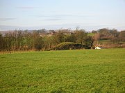
Moots may have met on existing archaeological mound sites such as tumuli or mottes; others on entirely natural mounds such as the one at Mugdock
or natural mounds which were modified for the intended purpose. One common aid to identification is size: most moot hills, in addition to lacking signs of defensive walls and ditches, are smaller than most mottes.
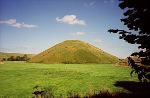
Some known moot hill sites are surrounded by water, such as Mugdock, Mound Wood and Court Hill at the Hill of Beith; others may well have been, such as Hutt Knowe. Such inaccessibility would have required the use of a boat or raised walkway. Wood Mound is clearly man-made and therefore the relationship between these sites and water may have had some functional or religious significance. Silbury Hill
is an example of how many Neolithic and Bronze Age monuments were built in liminal
or cross-over points in the landscape, and close to water.
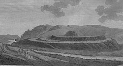
In ancient times, courts for the administration of justice were generally held in the open fields, and judgement was both given and executed in the same place; in every earldom, and almost every barony and jurisdiction of any considerable extent, there was a particular place alloted for that purpose; it was generally a small eminence, either natural or artificial, near the principal Mansion-house and was called the mote hill, or in Latin, mons placiti. In that place all the vassals of the jurisdiction were obliged to appear at iwdain times; and the superior gave judgement in such cases as fell within the powers committed to him by law or custom; in the same spot too, the gallows was erected for the execution of capital offenders; hence these places commonly go by the name of the Gallows Knoll; near the royal palaces there was usually a mote hill, where all the freeholders of the kingdom met together, both to transact public offices, and to do homage to their sovereign, who was seated on the top of the eminence. The mote hill at Scoons this day universally known. It is highly probable the Hurly Heaky (named after the sport of sliding down a slope on a trough or sledge; tobogganing) was the mote hill of the Castle of Sterling, or perhaps of a much larger jurisdiction. In 1360, a deadly feud which had long subsisted between the Drummonds and Menteaths, at that time two of the most powerful families in Perthshire, and which had heen the cause of much rapine and bloodshed, was composed by the interposition of Sir Robert Erskine and Sir Hugh Eglington, the two great justiciaries of the nation, in the neighbourhood, if not on the very mount. Our authority says, " Super ripam aquae de Forth juxta Strivelyn."
This mode of distributing justice appears to have been the custom of almost all nations, in the more early days of their state; and that it only to give their judicial procedures a greater appearance of impartiality and justice, by being carried on in public view, but because there were not houses large enough to contain the numbers that usually attended them. The court of Areopagus, at Athens, sat for many years after its first institution, in the open air.
Grose records that the last instance of a Baron Baillie sentencing and carrying out a death sentence in Nithsdale was at Barnside Hill in around 1697. Sir Robert Grierson, Bart was the baron concerned and the victim was a sheep stealer.
of religious houses record that they too used moot hills for holding courts.
The moot hills' part in the practice of law derives from the introduction of feudalism
by the Normans
in England or in Scotland by the Scottish kings such as David I
1125-1153 who introduced feudalism and delegated very extensive jurisdiction over large areas of land to men like the Walter the Steward (Renfrew & the northern half of Kyle) or de Morville (Cunningham) and they in turn delegated quite extensive powers to their own vassals. These invitees, largely of Norman, Fleming and Breton origin were, under feudal charter, given significant grants of land, were invited and did not come as conquerors as had been the case in England. There were in certain instances a close connection between the old Celtic thane
ages (a hereditary non-military tenant of the crown) and the new feudal baronies.
There was therefore no wholesale displacement of native lords in Scotland. In 1200 all the earls north of Forth and Clyde were still of Celtic descent; and as late as 1286, eight of the earldoms in Scotland were still in the hands of those of native stock. Many native lords were granted or confirmed in their lands in feudal form. Within a few generations, regular intermarriage and the Wars of Independence had removed most of the differences between native and incomer, although not those between Highlander and Lowlander.
Burgh courts were held in the open air, round the market cross, a standing stone, a moot hill or a prominent tree. These courts were held three times a year - the chief court after Pasch (Passover or Easter), the next after Michaelmas
, when the magistrates or burgh-reeves were elected, and the third after Yule
or Christmas. All burgesses were bound to attend.
 A Barony was an area of land, not always contiguous, granted by the Crown to a Tenant. Baronies became a unit in administration and law, however the actual size was variable and they merged or separated from time to time. The holder or Baron had power to hold courts which dealt with civil and criminal cases of less than major importance. Some crimes were reserved for royal courts, namely murder, rape, robbery with violence, fire raising and treason. To come under the jurisdiction of a baronial court, the crime had to have been committed within the barony or concerned its people or property.
In England a Baron was a peerage title, this was not the case in Scotland. He or she held their land directly from the King or Queen. After c1700 the emphasis was on administration, a good neighbourhood and economic and other rules for the benefit of those living within the Barony. In 1747 the criminal jurisdiction of a Baron Court was much restricted. The Barony was largely a self-governing community, however there was a system of appeals to the Sheriff and the Central Courts.
The term baron had simply meant "man" originally; later the term baron came to imply holding the barony lands immediately of the King. Finally baron came to mean one who held such lands "of the King" with accompanying rights and duties and the therefore the word came to mean one who held as 'tenant in chief' of the King's lands erected by Charter 'in free barony'. Sir John Skene in his glossary of Scots legal terms defines it as In this Realme he is called ane Barrone quha haldis his landes immediatlie in chiefe of the King and hes power of pit and gallow. The Barons of Scotland continued to have the right to sit in the Scottish Parliament until 1594.
The baron and the baron baillie, his deputy, and the Council, were concerned with such matters as: responsibility for repair to ditches and hedges, assessment of damage caused by cattle found on another's ground, under thirlage
laws, the maintenance of the mill race in good order and free from weeds and the mending of the mill dam. Even cases of neighbours using "unreasonable language", and "miscalling one another" were brought before the court. The court might also regulate the rotation of crops and the manuring of the ground. Ecclesiastical courts also existed as shown by the example of the Abbot of Kilwinning's court hill near Beith
. Three times a year the baron also had the right to clear his lands of evildoers and men of ill repute.
The feudal Baron appointed the Officers of a Baron Court. Barons therefore had public law executive and judicial authority over the public affairs of that Barony. The officers were:
By the Heritable Jurisdictions (Scotland) Act 1746
the powers of life and death were removed from the Baron Court and the criminal jurisdiction was very significantly reduced but not entirely abolished. The hereditary jurisdictions of Regality Courts and of the Sheriff Courts were abolished and the owners received significant sums in compensation. It can be stated therefore that most moot and gallow hills ceased to have a role in the judicial process at that time.
The Abolition of Feudal Tenure etc. (Scotland) Act 2000
removed all the remaining aspects of the feudal baronial system, apart from the baronial titles themselves. The entire system whereby land was held by a vassal on perpetual tenure from a superior, was, on this appointed day, abolished.
'. A pit, according to Mackenzie was a form of dungeon or prison cell, not a pit for drowning the condemned. Others take the view that the pit was the drowning pool for women and the gallows for the men. It is not clear why men were more likely to be hung and women drowned in a fen, river, pit or 'murder hole', however it may relate to ideas of decency. In Norse law the reason was that men, were sent to Wodan, and women were given to Ran
(a sea goddess) or Hel
. In Norse tradition the pit and gallows stood on the west of the moot-places or the prince's hall ready for use.
The 'furca and fossa', or the 'pit and gallows', refers to the high justice including the capital penalty. The furca was a device for hanging slaves in ancient Rome and refers to the gallows for hanging men; the fossa was a ditch filled with water for the drowning of women. As previously stated, the hereditary right of high justice survived until 1747 when it was removed from the barons and from the holders of Regalities
and sheriffdoms, by the Heritable Jurisdictions (Scotland) Act 1746.
It is not clear that the moot hill was also the actual site of executions; folklore, tradition and the association of separate 'gallow' places names with moot hills on balance suggests that the usual place of execution was a separate 'gallows hill'. At Gardyne Law however an eye witness recalled that judgement and execution took place on the same law. It does seems unlikely that in those superstitious days meetings would be held at places of death; at Mugdock
separate moot and gallow hills are a good example. Such gallows may have been built of worked timber or a Dule Tree
may have been used. RCAHMS records show that human bones have been frequently found in association with 'gallows' place name sites, but not at 'moot' sites. The term 'murder hole' may relate to the drowning sites, bones have been found close to some of these.
near Barrmill in North Ayrshire
a different method is said to have been employed, namely that of raising a flag at the Bore stone; a prominent site near the moot hill. It is likely that bonfires would have been lit as a signal, either from the smoke during the day or the light at night. A 'Bonfire hill' place name survives at Stewarton
in East Ayrshire
and a 'Bonfire knowe' is recorded at Kilmarnock. The Tarbolton
moot was still used for lighting bonfires up until the 19th-century at least and the name Shinny Hill is suggestive of traditional bonfires; a 'Shinicle' being a halloween bonfire.
. This practice may link with beliefs that lay behind the ceremonies at the petrosomatoglyph
footprints on Dunadd
and at other sites.
In the 15th-century the Tinwald
Mote near Dumfries
was still the legal head of the barony, where sasine
(possession) was given by the ceremony of handing the grantee, before witnesses, a handful of earth and stone from the head messuage called the Mote near the church of Tynwald. In mediaeval law the barony required a principal residence at which the legal process could be formally transacted, which explains why many such motes as that at Ellon
were retained, here by the earls of Buchan
, when little else remained of their possessions in the district. The mote still carried the dignity of the earldom.
The sasine is the legal act of register of land ownership, pronounced sayseen. Interestingly, in the context of the significance of the physical aspect of soil and stone, the act of conferring sasine was originally (for example in 1615) effected by the handing over of a bowl full of earth from the land and / or a stone of the house by the proprietor or seller to his heir or the buyer, who was then said to be seized of the land or house. Likewise the land rent payable was symbolised by the passing of a bowl of grass and the tithe as a bowl full of grain. The act of homage for holding a fief also involved the act of investiture. enacted by the delivering of a turf or a handful of earth to the individual to whom the land was being granted.
 In Scotland feudalism and its bonds of allegiance to the local laird was associated with the Jacobite rising
s with the result that the Hanoverian
Government took steps to undermine the system. After 1747 the moot hill was not used as a part of the baronial court process and the requirement for a gathering place for soldiers was also a thing of the past. The construction of Moot hall
s did away with the need to meet in the outdoors. Moot hills gradually ceased to have any significant role and many have suffered the final ignomy of being ploughed out and their existence almost or actually forgotten. Place names and local folklore have preserved the memory of a few, however records suggest that the majority have been destroyed. A few moot hills ended up with unlikely secondary uses, such as Knockenlaw, which was used as the 'blast wall' for a gunpowder magazine
and Chapel Hill which was used as a viewing point for watching horse racing.
A few, notably the Tynwald Hill in the Isle of Man
, continue to have a function in the 21st century. Some were built on and took on a new role, such as the moot hill at Riccarton
near Kilmarnock
, which had a kirk (church) built on it in 1823.
was a barony. Pre-reformation and other old gravestones often recorded the occupation of the individual, especially if they had held important roles such a baron baillie.


Early Middle Ages
The Early Middle Ages was the period of European history lasting from the 5th century to approximately 1000. The Early Middle Ages followed the decline of the Western Roman Empire and preceded the High Middle Ages...
Britain
Britain in the Middle Ages
England in the Middle Ages concerns the history of England during the Medieval period — from the end of Roman rule in Britain through to the Early Modern period...
, such hills were used for "moots", meetings of local people to settle local business. Among other things, proclamations might be read; decisions might be taken; court cases might be settled at a moot. Although some moot hills were naturally occurring features or had been created long before as burial mounds, others were purpose-built.
Etymology
Although the word "moot" or "mote", is of Old English origin, deriving from the verb to meet, it has come to have a wider meaning throughout the United Kingdom; initially referring to any popular gathering.In England the folkmoot in time came to be a more specific term for a local assembly with recognized legal rights and in Scotland the term is used in the literature for want of any other single accepted term.
Siting and purpose
Many moot, "mote" or "mute" hills are known by that name today. Others have local names such as Court Hill, Justice Hill, Judgement Hill, Mount, Munt, Moat Hill, Tandle, Downan, Bonfire Hill, Cuthill, etc. Many are also associated with names such as Knol, knock, knowe, or law.United Kingdom
The United Kingdom of Great Britain and Northern IrelandIn the United Kingdom and Dependencies, other languages have been officially recognised as legitimate autochthonous languages under the European Charter for Regional or Minority Languages...
, and some of them are known to have served as moot hills at some point in their existence. Terms include Tumulus, how, howe, low, tump, cnwc, pen, butt, toot, tot, cop, mount, mound, hill, knoll, mot, moot, knol, motte, and druid hill. Often the names are combined, as in Knockenlaw, Law Mount, etc.
Some hills known today as "moot hills" were actually historically mottes (from an unrelated French
French language
French is a Romance language spoken as a first language in France, the Romandy region in Switzerland, Wallonia and Brussels in Belgium, Monaco, the regions of Quebec and Acadia in Canada, and by various communities elsewhere. Second-language speakers of French are distributed throughout many parts...
word meaning "mound"), the remains of a motte-and-bailey
Motte-and-bailey
A motte-and-bailey is a form of castle, with a wooden or stone keep situated on a raised earthwork called a motte, accompanied by an enclosed courtyard, or bailey, surrounded by a protective ditch and palisade...
castle. (In this fortification, a wooden or stone keep
Keep
A keep is a type of fortified tower built within castles during the Middle Ages by European nobility. Scholars have debated the scope of the word keep, but usually consider it to refer to large towers in castles that were fortified residences, used as a refuge of last resort should the rest of the...
was built atop a small mound, usually man-made, which was in turn surrounded by a ditch and an outer ward called the "bailey".) In some cases a mound built as a motte may have seen later use as a functioning moot hill.
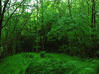
Moots may have met on existing archaeological mound sites such as tumuli or mottes; others on entirely natural mounds such as the one at Mugdock
Mugdock Country Park
Mugdock Country Park is a country park and historical site located partly in East Dunbartonshire and partly in Stirling, in the former county of Stirlingshire, Scotland...
or natural mounds which were modified for the intended purpose. One common aid to identification is size: most moot hills, in addition to lacking signs of defensive walls and ditches, are smaller than most mottes.
Some known moot hill sites are surrounded by water, such as Mugdock, Mound Wood and Court Hill at the Hill of Beith; others may well have been, such as Hutt Knowe. Such inaccessibility would have required the use of a boat or raised walkway. Wood Mound is clearly man-made and therefore the relationship between these sites and water may have had some functional or religious significance. Silbury Hill
Silbury Hill
Silbury Hill is a prehistoric artificial chalk mound near Avebury in the English county of Wiltshire. It is part of the Stonehenge, Avebury and Associated Sites UNESCO World Heritage Site, and lies at ....
is an example of how many Neolithic and Bronze Age monuments were built in liminal
Liminality
Liminality is a psychological, neurological, or metaphysical subjective state, conscious or unconscious, of being on the "threshold" of or between two different existential planes, as defined in neurological psychology and in the anthropological theories of ritual by such writers as Arnold van...
or cross-over points in the landscape, and close to water.
Cuthills
These were places of assembly in early medieval times, mostly in northern Scotland. The term (also Couthil or Cuthil) is found as a placename element at over sixty sites and many are associated with medieval shires or thanages. The term does not suggest a hill or mound site, being derived from the Gaelic term 'comhdhail', a place of assembly. Such assemblies were non-seignural burlaw courts and dealt with minor disputes.Francis Grose
Francis Grose in 1797 published his 'Antiquities of Scotland', and going from the 1789 date of the numerous engravings this was a little over forty years from the abolition of this aspect of the feudal system. Grose states mote hills, or places for administration of public justice, for considerable districts; and courts hills, whereon the ancient lairds held their baronial courts, before the demolition of the feudal system. These mote and court hills serve to explain the use of these high mounts still remaining near our ancient castles. He goes on to say -In ancient times, courts for the administration of justice were generally held in the open fields, and judgement was both given and executed in the same place; in every earldom, and almost every barony and jurisdiction of any considerable extent, there was a particular place alloted for that purpose; it was generally a small eminence, either natural or artificial, near the principal Mansion-house and was called the mote hill, or in Latin, mons placiti. In that place all the vassals of the jurisdiction were obliged to appear at iwdain times; and the superior gave judgement in such cases as fell within the powers committed to him by law or custom; in the same spot too, the gallows was erected for the execution of capital offenders; hence these places commonly go by the name of the Gallows Knoll; near the royal palaces there was usually a mote hill, where all the freeholders of the kingdom met together, both to transact public offices, and to do homage to their sovereign, who was seated on the top of the eminence. The mote hill at Scoons this day universally known. It is highly probable the Hurly Heaky (named after the sport of sliding down a slope on a trough or sledge; tobogganing) was the mote hill of the Castle of Sterling, or perhaps of a much larger jurisdiction. In 1360, a deadly feud which had long subsisted between the Drummonds and Menteaths, at that time two of the most powerful families in Perthshire, and which had heen the cause of much rapine and bloodshed, was composed by the interposition of Sir Robert Erskine and Sir Hugh Eglington, the two great justiciaries of the nation, in the neighbourhood, if not on the very mount. Our authority says, " Super ripam aquae de Forth juxta Strivelyn."
This mode of distributing justice appears to have been the custom of almost all nations, in the more early days of their state; and that it only to give their judicial procedures a greater appearance of impartiality and justice, by being carried on in public view, but because there were not houses large enough to contain the numbers that usually attended them. The court of Areopagus, at Athens, sat for many years after its first institution, in the open air.
Grose records that the last instance of a Baron Baillie sentencing and carrying out a death sentence in Nithsdale was at Barnside Hill in around 1697. Sir Robert Grierson, Bart was the baron concerned and the victim was a sheep stealer.
Origins
It is known that in Scotland, Brehons or Judges administered justice from 'Court Hills', especially in the highlands, where they were called a tomemoid (from Scots Gaelic tom a' mhòid) - that is, the Court Hillock. In ancient times suitable buildings would rarely have existed and there was usually no alternative other than to use an outdoor gathering place. It is said that Irish colonists brought with them Brehon law, the use of Moot hills and the law of Tannistry. Every baron had a moot hill and the chartulariesChartulary
A cartulary or chartulary , also called Pancarta and Codex Diplomaticus, is a medieval manuscript volume or roll containing transcriptions of original documents relating to the foundation, privileges, and legal rights of ecclesiastical establishments, municipal corporations, industrial...
of religious houses record that they too used moot hills for holding courts.
The moot hills' part in the practice of law derives from the introduction of feudalism
Feudalism
Feudalism was a set of legal and military customs in medieval Europe that flourished between the 9th and 15th centuries, which, broadly defined, was a system for ordering society around relationships derived from the holding of land in exchange for service or labour.Although derived from the...
by the Normans
Normans
The Normans were the people who gave their name to Normandy, a region in northern France. They were descended from Norse Viking conquerors of the territory and the native population of Frankish and Gallo-Roman stock...
in England or in Scotland by the Scottish kings such as David I
David I of Scotland
David I or Dabíd mac Maíl Choluim was a 12th-century ruler who was Prince of the Cumbrians and later King of the Scots...
1125-1153 who introduced feudalism and delegated very extensive jurisdiction over large areas of land to men like the Walter the Steward (Renfrew & the northern half of Kyle) or de Morville (Cunningham) and they in turn delegated quite extensive powers to their own vassals. These invitees, largely of Norman, Fleming and Breton origin were, under feudal charter, given significant grants of land, were invited and did not come as conquerors as had been the case in England. There were in certain instances a close connection between the old Celtic thane
Thane
Thane , is a city in Maharashtra, India, part of the Mumbai Metropolitan Region, northeastern suburb of Mumbai at the head of the Thane Creek. It is the administrative headquarters of Thane district. On 16 April 1853, G.I.P...
ages (a hereditary non-military tenant of the crown) and the new feudal baronies.
There was therefore no wholesale displacement of native lords in Scotland. In 1200 all the earls north of Forth and Clyde were still of Celtic descent; and as late as 1286, eight of the earldoms in Scotland were still in the hands of those of native stock. Many native lords were granted or confirmed in their lands in feudal form. Within a few generations, regular intermarriage and the Wars of Independence had removed most of the differences between native and incomer, although not those between Highlander and Lowlander.
Burgh courts were held in the open air, round the market cross, a standing stone, a moot hill or a prominent tree. These courts were held three times a year - the chief court after Pasch (Passover or Easter), the next after Michaelmas
Michaelmas
Michaelmas, the feast of Saint Michael the Archangel is a day in the Western Christian calendar which occurs on 29 September...
, when the magistrates or burgh-reeves were elected, and the third after Yule
Yule
Yule or Yuletide is a winter festival that was initially celebrated by the historical Germanic people as a pagan religious festival, though it was later absorbed into, and equated with, the Christian festival of Christmas. The festival was originally celebrated from late December to early January...
or Christmas. All burgesses were bound to attend.
Baronies
In England a Baron was a peerage title, this was not the case in Scotland. He or she held their land directly from the King or Queen. After c1700 the emphasis was on administration, a good neighbourhood and economic and other rules for the benefit of those living within the Barony. In 1747 the criminal jurisdiction of a Baron Court was much restricted. The Barony was largely a self-governing community, however there was a system of appeals to the Sheriff and the Central Courts.
The term baron had simply meant "man" originally; later the term baron came to imply holding the barony lands immediately of the King. Finally baron came to mean one who held such lands "of the King" with accompanying rights and duties and the therefore the word came to mean one who held as 'tenant in chief' of the King's lands erected by Charter 'in free barony'. Sir John Skene in his glossary of Scots legal terms defines it as In this Realme he is called ane Barrone quha haldis his landes immediatlie in chiefe of the King and hes power of pit and gallow. The Barons of Scotland continued to have the right to sit in the Scottish Parliament until 1594.
Baronial courts
Baronies were social units and their courts a form of council which enabled the area of the barony to function effectively as an early form of self-government. In mediaeval law the barony required a principal residence at which the legal process could be formally transacted. Many abandoned castles motes therefore continued in use for this purpose.The baron and the baron baillie, his deputy, and the Council, were concerned with such matters as: responsibility for repair to ditches and hedges, assessment of damage caused by cattle found on another's ground, under thirlage
Thirlage
Thirlage was the term used for the law in regard of the milling of grain for personal or other uses. Vassals in a feudal barony were thirled to their local mill owned by the feudal superior...
laws, the maintenance of the mill race in good order and free from weeds and the mending of the mill dam. Even cases of neighbours using "unreasonable language", and "miscalling one another" were brought before the court. The court might also regulate the rotation of crops and the manuring of the ground. Ecclesiastical courts also existed as shown by the example of the Abbot of Kilwinning's court hill near Beith
Beith
Beith is a small town situated in the Garnock Valley in North Ayrshire, Scotland approximately 20-miles south-west of Glasgow. The town is situated on the crest of a hill and was known originally as the "Hill o' Beith" after its Court Hill.-History:-Name:Beith's name is thought to emanate from...
. Three times a year the baron also had the right to clear his lands of evildoers and men of ill repute.
The feudal Baron appointed the Officers of a Baron Court. Barons therefore had public law executive and judicial authority over the public affairs of that Barony. The officers were:
- The Baron-Baillie was the principal administrative officer; the Baillie's insignia of office was a Cap of Justice, a Black legal Robe, and a medal of office on a chain
- The Baron-Clerk acted as administrative secretary of the Barony.
- The Dempster or Deemster was responsible for executing the judicial decisions and announced the "doom" as the sentence was called.
- The Baron-Sergeant kept order, summoned the parties involved and enforced civil decrees of the Court; the Sergeant's insignia of office was a 37" white Ellwand and a Horn to summon attendance.
- The Procurator Fiscal operated as the civil and criminal prosecutor in matters before the Baron Court.
By the Heritable Jurisdictions (Scotland) Act 1746
Heritable Jurisdictions (Scotland) Act 1746
The Heritable Jurisdictions Act 1746 was an Act of the British Parliament passed in the aftermath of the Jacobite rising of 1745....
the powers of life and death were removed from the Baron Court and the criminal jurisdiction was very significantly reduced but not entirely abolished. The hereditary jurisdictions of Regality Courts and of the Sheriff Courts were abolished and the owners received significant sums in compensation. It can be stated therefore that most moot and gallow hills ceased to have a role in the judicial process at that time.
The Abolition of Feudal Tenure etc. (Scotland) Act 2000
Abolition of Feudal Tenure etc. (Scotland) Act 2000
The Abolition of Feudal Tenure etc. Act 2000 was an act of the Scottish Parliament which was passed by the Parliament on 3 May 2000 and received Royal Assent on 9 June 2000....
removed all the remaining aspects of the feudal baronial system, apart from the baronial titles themselves. The entire system whereby land was held by a vassal on perpetual tenure from a superior, was, on this appointed day, abolished.
Pit and gallows
This phrase described the jurisdiction of a Baron in criminal cases; in full 'pit and gallows, sake and soke, toll, team, and infangthiefInfangthief and outfangthief
Infangthief and outfangthief were privileges originally granted to landowners in Anglo-Saxon law...
'. A pit, according to Mackenzie was a form of dungeon or prison cell, not a pit for drowning the condemned. Others take the view that the pit was the drowning pool for women and the gallows for the men. It is not clear why men were more likely to be hung and women drowned in a fen, river, pit or 'murder hole', however it may relate to ideas of decency. In Norse law the reason was that men, were sent to Wodan, and women were given to Ran
Rán
In Norse mythology, Rán is a sea goddess. According to Snorri Sturluson's Prose Edda book Skáldskaparmál, in his retelling of the Poetic Edda poem Lokasenna, she is married to Ægir and they have nine daughters together...
(a sea goddess) or Hel
Hel (being)
In Norse mythology, Hel is a being who presides over a realm of the same name, where she receives a portion of the dead. Hel is attested in the Poetic Edda, compiled in the 13th century from earlier traditional sources, and the Prose Edda, written in the 13th century by Snorri Sturluson...
. In Norse tradition the pit and gallows stood on the west of the moot-places or the prince's hall ready for use.
The 'furca and fossa', or the 'pit and gallows', refers to the high justice including the capital penalty. The furca was a device for hanging slaves in ancient Rome and refers to the gallows for hanging men; the fossa was a ditch filled with water for the drowning of women. As previously stated, the hereditary right of high justice survived until 1747 when it was removed from the barons and from the holders of Regalities
Regality
A regality was a territorial jurisdiction in old Scots law which might be created by the King only, by granting lands to a subject in liberam regalitatem, and also the tract of land over which such a right extended....
and sheriffdoms, by the Heritable Jurisdictions (Scotland) Act 1746.
It is not clear that the moot hill was also the actual site of executions; folklore, tradition and the association of separate 'gallow' places names with moot hills on balance suggests that the usual place of execution was a separate 'gallows hill'. At Gardyne Law however an eye witness recalled that judgement and execution took place on the same law. It does seems unlikely that in those superstitious days meetings would be held at places of death; at Mugdock
Mugdock Country Park
Mugdock Country Park is a country park and historical site located partly in East Dunbartonshire and partly in Stirling, in the former county of Stirlingshire, Scotland...
separate moot and gallow hills are a good example. Such gallows may have been built of worked timber or a Dule Tree
Dule Tree
Dule or dool trees in Britain were used as gallows for public hangings. They were also used as gibbets for the display of the corpse for a considerable period of time after such hangings...
may have been used. RCAHMS records show that human bones have been frequently found in association with 'gallows' place name sites, but not at 'moot' sites. The term 'murder hole' may relate to the drowning sites, bones have been found close to some of these.
The standard of Justice
An Ayrshire story tells of how an Ayrshire baron once strung up an innocent man, just because his visitor had never seen a man hanged before. Hopefully this was an isolated example, however the system suffered from many faults due to bias, lack of legal training, etc., etc. As stated, a right of appeal to Regalities and sheriffdoms courts did exist. Details of the sometimes shocking excesses of baron bailies can make painful reading. As their power was great and generally abused, so many of them enriched themselves. They had many ways of making money for themselves, such as (1) the bailie’s darak, as it was called, or a day’s labour in the year from every tenant on the estate; (2) confiscations, as they generally seized on all the goods and effects of such as suffered capitally; (3) all fines for killing game, blackfish, or cutting green wood were laid on by themselves, and went into their own pockets. These fines amounted to what they pleased almost. (4) Another very lucrative perquisite they had was what was called the Herial Horse, which was the best horse, cow, ox, or other article which any tenant on the estate possessed at the time of his death. This was taken from the widow and children for the bailie, at the time they had most need of assistance. This amounted to a great deal of extra income for the baillie of a large barony.Summoning people to the moot
At times it would be necessary to summon people to come to the mote for judgement, proclamations, gatherings, etc. This was sometimes done by ringing a bell, which was fitted upon or beside the moot hill, especially when a date for the meeting had not been previously set. At GreenhillsBarony and Castle of Giffen
The Barony of Giffen and its associated 15th-century castle were in the parish of Beith in the former District of Cunninghame, now North Ayrshire. The site may be spelled Giffen or Giffin and lay within the Lordship of Giffin, which included the Baronies of Giffen, Trearne, Hessilhead, Broadstone,...
near Barrmill in North Ayrshire
North Ayrshire
North Ayrshire is one of 32 council areas in Scotland with a population of roughly 136,000 people. It is located in the south-west region of Scotland, and borders the areas of Inverclyde to the north, Renfrewshire to the north-east and East Ayrshire and South Ayrshire to the East and South...
a different method is said to have been employed, namely that of raising a flag at the Bore stone; a prominent site near the moot hill. It is likely that bonfires would have been lit as a signal, either from the smoke during the day or the light at night. A 'Bonfire hill' place name survives at Stewarton
Stewarton
Stewarton is a town in East Ayrshire, Scotland. In comparison to the neighbouring towns of Kilmaurs, Fenwick, Dunlop and Lugton, it is a relatively large town, with a population of over 6,500. It is 300 feet above sea level.Groome, Francis H. . Ordnance Gazetteer of Scotland. Pub. Caxton. London....
in East Ayrshire
East Ayrshire
East Ayrshire is one of 32 council areas of Scotland. It borders on to North Ayrshire, East Renfrewshire, South Lanarkshire, South Ayrshire and Dumfries and Galloway...
and a 'Bonfire knowe' is recorded at Kilmarnock. The Tarbolton
Tarbolton
Tarbolton is a village in South Ayrshire, Scotland.- Meaning of place-name :Tarbolton has been suggested as having one of three meanings:...
moot was still used for lighting bonfires up until the 19th-century at least and the name Shinny Hill is suggestive of traditional bonfires; a 'Shinicle' being a halloween bonfire.
Links with the land
It is interesting to note the significance of direct links with the land shown by the standing on 'home' soil at the Scone moot, the use of soil from each parish in the building of the Tynwald Hill and the discovery of soil from several distant locations at the centre of Silbury HillSilbury Hill
Silbury Hill is a prehistoric artificial chalk mound near Avebury in the English county of Wiltshire. It is part of the Stonehenge, Avebury and Associated Sites UNESCO World Heritage Site, and lies at ....
. This practice may link with beliefs that lay behind the ceremonies at the petrosomatoglyph
Petrosomatoglyph
A petrosomatoglyph is an image of parts of a human or animal body incised in rock. Many were created by Celtic peoples, such as the Picts, Scots, Irish, Cornish, Cumbrians, Bretons and Welsh. These representations date from the Early Middle Ages; others of uncertain purpose date back to megalithic...
footprints on Dunadd
Dunadd
Dunadd, , is an Iron Age and later hillfort near Kilmartin in Argyll and Bute, Scotland and believed to be the capital of the ancient kingdom of Dál Riata.-Description:...
and at other sites.
In the 15th-century the Tinwald
Tinwald, Scotland
Tinwald is a village in Dumfries and Galloway, Scotland, lying a little north of Locharbriggs outside Dumfries.Tinwald was the birthplace of William Paterson, who helped to found the Bank of England....
Mote near Dumfries
Dumfries
Dumfries is a market town and former royal burgh within the Dumfries and Galloway council area of Scotland. It is near the mouth of the River Nith into the Solway Firth. Dumfries was the county town of the former county of Dumfriesshire. Dumfries is nicknamed Queen of the South...
was still the legal head of the barony, where sasine
Sasine
Sasine is the delivery of feudal property, typically land.Feudal property means immovable property, and includes everything that naturally goes with the property. For land, that would include such things as buildings, trees, and underground minerals...
(possession) was given by the ceremony of handing the grantee, before witnesses, a handful of earth and stone from the head messuage called the Mote near the church of Tynwald. In mediaeval law the barony required a principal residence at which the legal process could be formally transacted, which explains why many such motes as that at Ellon
Ellon, Aberdeenshire
Ellon is a town in Aberdeenshire, Scotland, approximately north of Aberdeen, lying on the River Ythan which has one of the few undeveloped river estuaries on the Eastern coast of Scotland. It is in the ancient region of Formartine...
were retained, here by the earls of Buchan
Buchan
Buchan is one of the six committee areas and administrative areas of Aberdeenshire Council, Scotland. These areas were created by the council in 1996, when the Aberdeenshire unitary council area was created under the Local Government etc Act 1994...
, when little else remained of their possessions in the district. The mote still carried the dignity of the earldom.
The sasine is the legal act of register of land ownership, pronounced sayseen. Interestingly, in the context of the significance of the physical aspect of soil and stone, the act of conferring sasine was originally (for example in 1615) effected by the handing over of a bowl full of earth from the land and / or a stone of the house by the proprietor or seller to his heir or the buyer, who was then said to be seized of the land or house. Likewise the land rent payable was symbolised by the passing of a bowl of grass and the tithe as a bowl full of grain. The act of homage for holding a fief also involved the act of investiture. enacted by the delivering of a turf or a handful of earth to the individual to whom the land was being granted.
The demise of moot hills
Jacobite rising
The Jacobite Risings were a series of uprisings, rebellions, and wars in Great Britain and Ireland occurring between 1688 and 1746. The uprisings were aimed at returning James VII of Scotland and II of England, and later his descendants of the House of Stuart, to the throne after he was deposed by...
s with the result that the Hanoverian
House of Hanover
The House of Hanover is a deposed German royal dynasty which has ruled the Duchy of Brunswick-Lüneburg , the Kingdom of Hanover, the Kingdom of Great Britain, the Kingdom of Ireland and the United Kingdom of Great Britain and Ireland...
Government took steps to undermine the system. After 1747 the moot hill was not used as a part of the baronial court process and the requirement for a gathering place for soldiers was also a thing of the past. The construction of Moot hall
Moot hall
A moot hall is meeting or assembly building, traditionally to decide local issues.In Anglo-Saxon England, a low ring-shaped earthwork served as a moot hill or moot mound, where the elders of the hundred would meet to take decisions. Some of these acquired permanent buildings, known as moot halls...
s did away with the need to meet in the outdoors. Moot hills gradually ceased to have any significant role and many have suffered the final ignomy of being ploughed out and their existence almost or actually forgotten. Place names and local folklore have preserved the memory of a few, however records suggest that the majority have been destroyed. A few moot hills ended up with unlikely secondary uses, such as Knockenlaw, which was used as the 'blast wall' for a gunpowder magazine
Gunpowder magazine
A gunpowder magazine is a magazine designed to store the explosive gunpowder in wooden barrels for safety. Gunpowder, until superseded, was a universal explosive used in the military and for civil engineering: both applications required storage magazines...
and Chapel Hill which was used as a viewing point for watching horse racing.
A few, notably the Tynwald Hill in the Isle of Man
Isle of Man
The Isle of Man , otherwise known simply as Mann , is a self-governing British Crown Dependency, located in the Irish Sea between the islands of Great Britain and Ireland, within the British Isles. The head of state is Queen Elizabeth II, who holds the title of Lord of Mann. The Lord of Mann is...
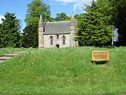
, continue to have a function in the 21st century. Some were built on and took on a new role, such as the moot hill at Riccarton
Riccarton, Ayrshire
Riccarton is a village and parish in East Ayrshire, Scotland. It lies across the River Irvine from Kilmarnock. The river Irvine divides the parishes of Riccarton and Kilmarnock and the river used to form the boundary between the districts of Kyle and Cunninghame.- History :The village became a...
near Kilmarnock
Kilmarnock
Kilmarnock is a large burgh in East Ayrshire, Scotland, with a population of 44,734. It is the second largest town in Ayrshire. The River Irvine runs through its eastern section, and the Kilmarnock Water passes through it, giving rise to the name 'Bank Street'...
, which had a kirk (church) built on it in 1823.
Locating old moot hills
Many barony lands were merged with other baronies at one time or other and therefore some of the associated moot hills would have ceased to have a role well before the demise of the baronial courts in 1747. Moot hills in this category may have remained as features of the landscape, but often without any local traditions relating to them being recorded. Place names are a guide, especially if local traditions have survived as well. Written records often survive, such as in 1346 a William Baillie, the Baillie of Lambistoun or Lambimtoun, vulgarly called Lamington is listed by Dalrymple amongst the prisoners taken by the English at the Battle of Durham which had taken place on 17 October of that year. He was in the company of a Thomas Boyd of Kilmarnock and Andrew Campbell of Loudoun. This helps to confirm that modern day LambroughtonLambroughton
Lambroughton is a village in the old Barony of Kilmaurs, North Ayrshire, Scotland. This is a rural area famous for its milk and cheese production and the Ayrshire or Dunlop breed of cattle.-Origins of the name:...
was a barony. Pre-reformation and other old gravestones often recorded the occupation of the individual, especially if they had held important roles such a baron baillie.
A list of Moot hills, Gallows hills, their associated Baronies and other details
Records of these sites have often been lost & therefore the barony and other associations have only been made where the evidence is credible, backed up by written records, place names or by oral folklore.Aberdeenshire
- Court Hill (NJ 7075 4603), Braefoot. A small conical hill, entirely cultivated, situated on the south-west side of Braefoot. Tradition affirms this to have originally been an ancient seat of the baronial court hence the name. 57.5035°N 2.4898°W
- Gallowhill, BanffBanff, AberdeenshireBanff is a town in the Banff and Buchan area of Aberdeenshire, Scotland. Banff is situated on Banff Bay and faces the town of Macduff across the estuary of the River Deveron...
. In 1700 a Freebooter, James McPherson, was locked up in the tolbooth before being hanged, the clock in Banff was reputedly put forward one hour to ensure he was hanged because any possible reprieve arrived. He may have been hanged on the gallowhill.
- Gallows Hill (NK 065 365). Parish of CrudenCruden BayCruden Bay is a small village in Scotland, on the north coast of the Bay of Cruden in Aberdeenshire, 26 miles north of Aberdeen.Just south of Slains Castle, Cruden Bay was the site of a battle between Danes and Scots under King Malcolm II in 1012...
. A small hill where criminals were executed and where human skeletons have been found. A deep pool in the Water of Cruden opposite is where others were drowned. The moot hill must have been nearby. 57.4188°N 1.8934°W
- Moat-head, Auchterless. Near the parish church. The Gallow hill is nearby. 57.4629°N 2.4784°W
- Moot Hill, EllonEllon, AberdeenshireEllon is a town in Aberdeenshire, Scotland, approximately north of Aberdeen, lying on the River Ythan which has one of the few undeveloped river estuaries on the Eastern coast of Scotland. It is in the ancient region of Formartine...
. The site of the court of the Celtic MormaerMormaerThe title of Mormaer designates a regional or provincial ruler in the medieval Kingdom of the Scots. In theory, although not always in practice, a Mormaer was second only to the King of Scots, and the senior of a toisech.-Origin:...
s and the Norman Earls of BuchanEarl of BuchanThe Mormaer or Earl of Buchan was originally the provincial ruler of the medieval province of Buchan. Buchan was the first Mormaerdom in the High Medieval Kingdom of the Scots to pass into the hands of a non-Scottish family in the male line. The earldom had three lines in its history, not counting...
is located next to the Riverside car park and today is marked with a small monument and seating area. 57.36675°N 2.06815°W
Angus
- Courthill (NO 6740 5140). Parish of Lunan. The nearby farm preserves the name of the moot hill where the barons of Red Castle held their courts. 56.6533°N 2.5333°W
- Court Hillock (NO 3798 5415), KirriemuirKirriemuirKirriemuir, sometimes called Kirrie, is a burgh in Angus, Scotland.-History:The history of Kirriemuir extends to the early historical period and it appears to have been a centre of some ecclesiastical importance...
. The Court Hillock, called a 'mote' in 1909, had been levelled by 1884. 56.67498°N 3.01374°W
- Gallows Knowe, Lintrathen. This artificial mound is about 45 yards in diameter and between 12 and 15 feet (4.6 m) high. Three stone cists have been found within the knowe.
- Gardyne Law, near Gardyne Castle, 1¼ miles (2 km) southwest of FriockheimFriockheimFriockheim is a village in Angus, Scotland dating from 1814. It lies between the towns of Brechin, Montrose, Arbroath and Forfar.-History:...
and 3 miles (4.8 km) east of Letham. An old man told Thomas Lyel, Esq., that he saw two Highlanders, taken with stolen cattle, judged, condemned, and hanged on the Law of Gardyne.
Argyll and Bute
- Court Hills or Gallowhill (NS 3521 8793). Parish of LussLussLuss is a village in Argyll & Bute, Scotland, on the west bank of Loch Lomond.-History:Historically in the County of Dunbarton, its original name is Clachan dubh, or 'dark village'...
. About 1 3/4 miles from Rossdhu, are two natural mounds which were formerly the Courthill and Gallowshill of the Clan ColquhounClan ColquhounClan Colquhoun is a Highland Scottish clan.The clan motto shown above in the crest best translates to "if I can."-Origins of the clan:In the 13th century Maol Domhnaich, Earl of Lennox granted the lands of Colquhoun, located in Dunbartonshire, to Humphry de Kilpatrick...
and the barony of Luss may still be seen near the gamekeeper's house about 2 miles (3 km) from Rossdhu. 56.0558°N 4.64790°W
Ayrshire (East)
- Bowie's Munt - KilmaursKilmaursKilmaurs is a village in East Ayrshire, Scotland. It lies on the Carmel, 21.1 miles south by west of Glasgow. Population recorded in 2001 Census, 2601- History :...
, East Ayrshire. A large wooded mound on the outskirts of the village, surrounded by a circular ditch and bank. The farms nearby are known are Knocklandside and Knocklandhill. 55.3818°N 4.3234°W
- Castle Lowrie - Barony of Loudoun, DarvelDarvelDarvel is a small town in East Ayrshire, Scotland, located at the eastern end of the Irvine Valley and is sometimes referred to as "The Lang Toon" due to its quaint appearance on Ordnance Survey maps....
. Recorded as a natural mote hill, a meeting-place on the Glen WaterRiver IrvineThe River Irvine is a river flowing through southwest Scotland, with its watershed on the Lanarkshire border of Ayrshire at an altitude of above sea-level, near Drumclog, and SW by W of Strathaven...
, near Bankhead Farm.
- Chapel Hill, ChapeltounChapeltounChapeltoun is an estate on the banks of the Annick Water in East Ayrshire, Scotland. This is a rural area famous for its milk and cheese production and the Ayrshire or Dunlop breed of cattle.-Templeton and the Knights Templar:...
, StewartonStewartonStewarton is a town in East Ayrshire, Scotland. In comparison to the neighbouring towns of Kilmaurs, Fenwick, Dunlop and Lugton, it is a relatively large town, with a population of over 6,500. It is 300 feet above sea level.Groome, Francis H. . Ordnance Gazetteer of Scotland. Pub. Caxton. London....
. 20 feet (6 m) high on the low side and 7 feet (2.1 m) on the high side. A flat top, 22 paces in diameter. A likely Moot Hill as it is unclear where the chapel stood. Also known as the Monk's graveyard and Jockey's cap, as it was used as a viewing platform to watch horse races at festival times. A Moot Hill of Chapelton is recorded in the Register of the Great Seal of Scotland as being specifically excluded by King James from a grant of lands including Lainshaw, Robertland and Gallowberry to Alexander Hume in the 15th-century. 55.3953°N 4.32319°W
- Court Hill, a short distance to the south of Aiket Castle. Cunninghame family. DunlopDunlop, East AyrshireDunlop is a village and parish in East Ayrshire, Scotland. It lies on the A735, north-east of Stewarton, seven miles from Kilmarnock. The road runs on to Lugton and the B706 enters the village from Beith.-The village:...
area. The name applies to the vestiges of a small hill, which appears to have been much higher at one time. It is situated in the corner of a small field near the house called Aiket Mill. Local informants stated that this was where the feues due to the proprietor of Aiket Castle (NS34NE 1) were paid.
- Craighead Lea or Law hill, near LugtonLugtonLugton is a small village or hamlet in East Ayrshire, Scotland with a population of 80 people. The A736 road runs through on its way from Glasgow, to the north, to Irvine in North Ayrshire. Uplawmoor is the first settlement on this 'Lochlibo Road' to the north and Burnhouse is to the south...
. This is said to have been a place of trial and it had an arrangement of boulders on its summit until a farmer moved them to aid ploughing of the area.
- Craigie Moot - Smith records that a moot hill existed near the village of CraigieCraigie Castle, AyrshireCraigie Castle in the old Barony of Craigie, is a ruined fortification situated about southeast of Kilmarnock and southeast of Craigie village, in the Parish of Craigie, South Ayrshire, Scotland....
.
- Dalmellington Moat Hill (NS 482 058). DalmellingtonDalmellingtonDalmellington is a market town in Ayrshire, Scotland. In 2001 it had a population of 1407. The town owes its origins to the fault line separating the Southern Uplands of Scotland from the Central Lowlands...
's mound is 154 paces in circumference at the base, surrounded by a ditch, 9 feet (3 m) broad at the bottom, and 4 feet (1 m) deep. Measured from the bottom of this ditch, the mound is 28 feet (9 m) high; the top is 22 paces in diameter, the sides are very steep. A wooden stairs was fitted to the top in Smith's time (1890s). He records that it may have been a fort at one time as well as being used as a moot hill later. A Gillies Knowe, possibly a corruption of Gallows Knowe, is nearby. 55.3228°N 4.394°W
- Greenhill (NS 401 391), KnockentiberKnockentiberKnockentiber is a village in East Ayrshire, Parish of Kilmaurs, Scotland. Knockentiber is WNW of Kilmarnock and 1/2 mile NE of Crosshouse. Latitude:55.6193°N Longitude:4.5455°W and . The population was 359 in 1991, however the population is much higher following the construction of several...
. The base is 140 paces in diameter; it is 15 in 6 in (4.72 m) high, and measures 25 opaces across the circular top. 55.6191°N 4.5407°W
- Highlangside Moot hill - Smith records that a moot hill existed here in the CraigieCraigie Castle, AyrshireCraigie Castle in the old Barony of Craigie, is a ruined fortification situated about southeast of Kilmarnock and southeast of Craigie village, in the Parish of Craigie, South Ayrshire, Scotland....
district.
- Judge's Hill (NS 519 386) - Barony of Loudoun. Shown on the old OS maps under this name. A man made 'Moot Hill' near to the old Loudoun Castle, sometimes called Arclowdun, standing on the Hag Burn. Judge's Hill also stands close to the Hag or Bowhill Burn. This may well be the Justice hill for the Campbell's of Earl's of Loudoun. A Gallows Hill is situated near the upper reaches of the Burn Anne above Shinny Hill.55.61813°N 4.35233°W
- Judgement Seat (NS 463 324), in the Carnell estate woods, Fiveways. It overlooks the Cessnock Water. It is close to the old tower of Cairnhill, now Carnell. The nearby Dollar Hill Mound (Hill of GriefDule TreeDule or dool trees in Britain were used as gallows for public hangings. They were also used as gibbets for the display of the corpse for a considerable period of time after such hangings...
) may have been the Gallows Hill associated with the Judgement Seat. 55.561°N 4.4386°W
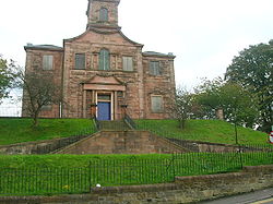
- Judgement Seat in RiccartonRiccarton, AyrshireRiccarton is a village and parish in East Ayrshire, Scotland. It lies across the River Irvine from Kilmarnock. The river Irvine divides the parishes of Riccarton and Kilmarnock and the river used to form the boundary between the districts of Kyle and Cunninghame.- History :The village became a...
near KilmarnockKilmarnockKilmarnock is a large burgh in East Ayrshire, Scotland, with a population of 44,734. It is the second largest town in Ayrshire. The River Irvine runs through its eastern section, and the Kilmarnock Water passes through it, giving rise to the name 'Bank Street'...
. A Kirk (church), built in 1823, now stands on the old justice mound. 55.5952°N 4.4964°W
- Justice Hill or Judas hill overlooking the Craufurdland Water. Near Dean castle, KilmarnockKilmarnockKilmarnock is a large burgh in East Ayrshire, Scotland, with a population of 44,734. It is the second largest town in Ayrshire. The River Irvine runs through its eastern section, and the Kilmarnock Water passes through it, giving rise to the name 'Bank Street'...
. The BoydsClan BoydClan Boyd is a Lowland Scottish clan from Kilmarnock in Ayrshire, Scotland.-Origins of the clan:The origin of the Boyd family name may be either from the Gaelic language or from the Normans, but in both cases translates as 'fair', 'blonde', 'yellow or fair,' etcetera...
, Lords of Kilmarnock, had this moot hill and their gallows was at Gallows-Knowe which stood in Wellington street, Kilmarnock. It is also said to be the burial site of men killed in battle.
- Knockenlaw (NS 425 396), Barony of Roberton, KilmarnockKilmarnockKilmarnock is a large burgh in East Ayrshire, Scotland, with a population of 44,734. It is the second largest town in Ayrshire. The River Irvine runs through its eastern section, and the Kilmarnock Water passes through it, giving rise to the name 'Bank Street'...
. A final traditional use of the mound was in the holding of a 'court' at Knockenlaw by the Earl of Glencairn when he was attempting to claim the Lordship of Kilmarnock from the Boyd's. In the event the supporters of the Boyd's turned up in force and the Earl had to abandon his attempt. A powder magazine was later built into the mound, of which little now remains (2007). 55.6244°N 4.5029°W
- Knockmarloch in the CraigieCraigie Castle, AyrshireCraigie Castle in the old Barony of Craigie, is a ruined fortification situated about southeast of Kilmarnock and southeast of Craigie village, in the Parish of Craigie, South Ayrshire, Scotland....
district. Smith records that a moot hill existed here.
- Law Mount (NS 411 447), Barony of LambroughtonLambroughtonLambroughton is a village in the old Barony of Kilmaurs, North Ayrshire, Scotland. This is a rural area famous for its milk and cheese production and the Ayrshire or Dunlop breed of cattle.-Origins of the name:...
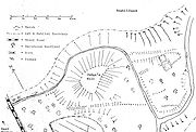
and / or Lainshaw by Stewarton. It is also known as Moat Hill or a Moot Hill overlooking Lainshaw House and above Castleton (previously Over or High Castleton). It is an artificial mound which was thought to have a bailey and therefore be a castle motte, hence the name of the farms. Linge is of the opinion that the supposed bailey, clearly visible form the road under the appropriate light conditions, is a natural geographic feature. The mound is 19 m (62 ft) in diameter and 3.5 m (11.5 ft) in height. At the top its diameter is 12 m (39 ft) and seen by satellite imagery it is clearly too small to have been a motte. The secondary use of the mound and fits with its more recent local names, is that it was the site of the Justice Hill where proclamations of the Lainshaw Castle or possibly the Lambroughton Baronial Court's judgements were made. 55.6697°N 4.5281°W
- Main Castle, Barony of Loudoun, DarvelDarvelDarvel is a small town in East Ayrshire, Scotland, located at the eastern end of the Irvine Valley and is sometimes referred to as "The Lang Toon" due to its quaint appearance on Ordnance Survey maps....
. Recorded as an artificial mote hill, a meeting-place in a bend of the Avon WaterRiver IrvineThe River Irvine is a river flowing through southwest Scotland, with its watershed on the Lanarkshire border of Ayrshire at an altitude of above sea-level, near Drumclog, and SW by W of Strathaven...
, where tribal laws were made and open-air courts of justice were held.
- Mote, now Carmelbank farm, Crosshouse. Carmel BankThorntoun house and estateThorntoun School was opened by Barnardo's in September 1971 for children with emotional difficulties aged 11 to 16 years. The school closed in 1990 and Thorntoun is now a Nursing Home. The complex lies between the villages of Springside and Crosshouse, Kilmarnock in East Ayrshire, Scotland...
House was formerly known as 'Mot' or 'Mote' House and was the site of a Moot Hill, possibly for the barony of Thorntoun.
- Shinny Hill (NS 525 367). GalstonGalston, East AyrshireGalston is a town in East Ayrshire, Scotland which has a population of 5000 . It is situated in wooded countryside 4 miles up-river from Kilmarnock and is one a group of the small towns located in the Irvine Valley between the towns of Hurlford and Newmilns. Galston is located in the Loudoun area...
. A striking hill with a nearby cairn and Gallow Law overlooking it. The Scots name 'Shinicle' refers to a HalloweenHalloweenHallowe'en , also known as Halloween or All Hallows' Eve, is a yearly holiday observed around the world on October 31, the night before All Saints' Day...
bonfire, but no local traditions appear to record this activity. Saint Anne's well and the Burn Anne are nearby. 55.6015°N 4.3427°W
Ayrshire (North)
- Court Hill (NS 292 495), Dalry. Barony of Ardrossan. A barrow and a moot hill. Previously 290 feet (88 m) in circumference, 20 feet (6 m) high and the diameter of the flat top was 38 feet (12 m). Covered in pit refuse and then excavated and the results published. It had a wooden castle on its summit at one point in its history. A Gallow's stone is said to have stood a short distance to the east of the hill.
- Court Hill, near Hill of BeithBeithBeith is a small town situated in the Garnock Valley in North Ayrshire, Scotland approximately 20-miles south-west of Glasgow. The town is situated on the crest of a hill and was known originally as the "Hill o' Beith" after its Court Hill.-History:-Name:Beith's name is thought to emanate from...
in the Barony of Beith. Dobie states that the Abbot of Kilwinning used it to administered justice to his vassals & tenants. It is a sub-oval, flat-topped mound, measuring 15.0 by 14.5 metres (49.2 x 47.6 ft) over all, 10.0 by 8.0 metres (32.8 x 26.25 ft) across the top, and 2 m (6.6 ft) high, situated at the foot of a small valley. A number of large stones are visible in the sides of the mound. It is turf-covered, and probably situated on a low outcrop, it is mostly an artificial work. It pre-dates the channelling of the burn which detours around it, the mound was probably isolated in this once marshy outflow of the former Boghall Loch (see NS35SE 14). It does not seem to lie in the area identified by Smith.
- Giffordland, Dalry. The small Barony of GiffordlandGiffordland, AyrshireGiffordland is in North Ayrshire, Parish of Dalry in the former Region of Strathclyde.- Introduction :Giffordland was only a small barony, however the families associated with it played an active part in the history of feudal Scotland....
was held by the Giffords and later the Craufurd, Blair and Morris families.(Map reference: NS 2662 4893)
- Glen Mount, West KilbrideWest KilbrideWest Kilbride is a village in North Ayrshire, on the west coast of Scotland by the Firth of Clyde, looking across the water to Goat Fell and the Isle of Arran...
.
- Green Hill, LargsLargsLargs is a town on the Firth of Clyde in North Ayrshire, Scotland, about from Glasgow. The original name means "the slopes" in Scottish Gaelic....
. Known at one time as Moot Hill because it may have been used as a court or law area moot by local lairds during the Medieval times.
- Green hill, Barony of GiffenBarony and Castle of GiffenThe Barony of Giffen and its associated 15th-century castle were in the parish of Beith in the former District of Cunninghame, now North Ayrshire. The site may be spelled Giffen or Giffin and lay within the Lordship of Giffin, which included the Baronies of Giffen, Trearne, Hessilhead, Broadstone,...
, BarrmillBarrmillBarrmill is a small village in North Ayrshire, Scotland about a mile and a half a mile east of Beith on the road to Lugton. Locally it is known as the Barr.- History :General Roy's survey of 1747 - 55 shows only the farm of High Barr...
. The moot hill stood near to Greenhill farm. This artificial mound was the site where proclamations of the Giffen Castle Baronial Court's judgements were made. No sign of the Moot hill seems to survive, however a bridge near to Greenhill is marked as 'Tappethillock', meaning a flat-topped hillock, which may refer to it.
- Hutt Knowe or Hut Knol (NS 375 441), BonshawChapeltounChapeltoun is an estate on the banks of the Annick Water in East Ayrshire, Scotland. This is a rural area famous for its milk and cheese production and the Ayrshire or Dunlop breed of cattle.-Templeton and the Knights Templar:...
, Barony of Bollingshaw. 'Huit' in Scots is a heap or stack. It also known as Bonshaw or Bollingshaw Mound, 17 m (56 ft) in diameter and 2.7 m (8.9 ft) high, variously described as a mounded corn-kiln or lime kiln. Corn-drying kilns were often built into sloping ground or existing mounds. It is said to have large integral basal stones and was described in 1890 as having culverts or 'penns' in its sides, although these are not visible today. This mound has been excavated on several occasions without enough evidence being uncovered to determine its purpose. It lies close to the Glazert; Stacklawhill is nearby. A limekiln and a rarely mentioned ice house are also present on the site and this seems to have resulted in some confusion arising over the description of Hutt Knowe. Satellite imagery clearly shows that the mound stands on a raised irregularly shaped platform.55.3949°N 4.333°W
- Irvine Moor had a possible moot hill with a gallows hill nearby. It was 20 paces in diameter, 2 in 6 in (0.762 m) high on one side and 13 in 8 in (4.17 m) on the other. Gallows muir is one name given to the site on the older maps of the area.
- Knockrivoch (NS 253 451), Saltcoats.
- Law, AuchenmadeAuchentiberThe hamlet of Auchentiber is in North Ayrshire, Parish of Kilwinning, Scotland. Auchentiber is NE of Kilwinning on the Lochlibo Road, from the hamlet of Burnhouse and from the village of Barrmill. Grid Ref. NS3647. Some new housing has been built, but the settlement is still very much a hamlet...
. This moot hill lay half a mile to the east of Pencote Hill, near Auchenmade & had been ploughed out by 1895.
- Law hill - Symington. Barony of Symington. This moot lay at the bottom of the village and was completely levelled as part of improvements, by a Mr. Boyd in around 1860. Iron arrowheads and combs of horn were found during the demolition.
- Law Mound, twelve paces in diameter, at Threepwood near Barcraigs Reservoir.
- Lawthorn Mount (NS 346 407), PercetonPercetonPerceton is a medieval settlement and estate in North Ayrshire, Scotland, near the town of Irvine. The old church in Perceton is one of the oldest buildings in the Irvine district...
. Also a cairn or barrow. It is 21 paces in diameter at the base, and 14 feet (4 m) in diameter on the top, the height being 9 in 8 in (2.95 m) It is said by oral tradition to have been a Justice hill. StanecastleStanecastleStanecastle was a medieval barony and estate in North Ayrshire, Scotland, first mentioned in 1363 and now part of the Irvine New Town project. Its nearest neighbours are Bourtreehill and Girdle Toll.-Roman origins?:...
castle is nearby.
- Mound Wood near Kennox House and moss. An oval mound with drystone walling around it. Gallowayford is situated nearby on the Glazert Water. 55.4037°N 4.3450°W
- Mount (NS 202 585), LargsLargsLargs is a town on the Firth of Clyde in North Ayrshire, Scotland, about from Glasgow. The original name means "the slopes" in Scottish Gaelic....
. Situated near the old church of LargsLargsLargs is a town on the Firth of Clyde in North Ayrshire, Scotland, about from Glasgow. The original name means "the slopes" in Scottish Gaelic....
. Said by some to be the moot hill for Largs, but others see it as a burial mound for Norwegians (Norse).
- Stacklawhill near Bonshaw. Barony of Bollingshaw. StewartonStewartonStewarton is a town in East Ayrshire, Scotland. In comparison to the neighbouring towns of Kilmaurs, Fenwick, Dunlop and Lugton, it is a relatively large town, with a population of over 6,500. It is 300 feet above sea level.Groome, Francis H. . Ordnance Gazetteer of Scotland. Pub. Caxton. London....
. A moot or gallows hill-like wooded mound (Dule TreeDule TreeDule or dool trees in Britain were used as gallows for public hangings. They were also used as gibbets for the display of the corpse for a considerable period of time after such hangings...
) set on high ground above the Hutt Knowe mound at Bonshaw. Hutt means heap or stack, so this may be the gallow hill of the stack law, i.e. Hutt Knowe Moot. The Glazert Water runs nearby. 55.3931°N 4.3520°W
Ayrshire (South)
- Law Hill - The Fullartons of Fullarton house, TroonTroonTroon is a town in South Ayrshire. It is situated on the west coast of Scotland, about eight miles north of Ayr and three miles northwest of Glasgow Prestwick International Airport. Lying across the Firth of Clyde, the Isle of Arran can be seen. Troon is also a port with freight and ferry services...
, dispensed justice at the Law Hill which was close to their mansion. Farming activity reduced the moot hill and almost levelled it, so that a Pillar was erected there to mark the spot. This pillar was later removed and rebuilt with embellishments at the back gate of Monklands on the Isle O'Pins Road.
- Barons Stone - Parish of GirvanGirvanGirvan is a burgh in Carrick, South Ayrshire, Scotland, with a population of about 8000 people. Originally a fishing port, it is now also a seaside resort with beaches and cliffs. Girvan dates back to 1668 when is became a municipal burgh incorporated by by charter...
. At Killochan castle this stone, an erratic, once formed part of a cliff, 2000 feet (609.6 m) over its present site, far away among the hills of Loch Doon. In historical times, it formed the "Hill of Justice" of the barons of Killochan, where they mustered their men, planned their raids, shared their booty, and hanged troublesome prisoners.
- Court Knowe, BallantraeBallantraeBallantrae is a community in Carrick, South Ayrshire, Scotland. The name probably comes from the Scottish Gaelic Baile na Tràgha, meaning the "town by the beach"....
. ( 55.1111°N 4.9474°W)
- Hall Of Auchincross or Court Hill (NS 5834 1407). Parish: New CumnockNew CumnockNew Cumnock is a place in East Ayrshire, Scotland. It expanded during the coal mining era but, like so many others, suffered after the deep shaft pits closed in the 1980's...
. A court knowe near the Hall of Auchincross, on which criminals are said to have been tried by the laird of Auchincross. A low, rounded knoll, roughly 30 by, under pasture. The farmer at Hall of Auchincross stated that its profile was once sharper but that it has been reduced in recent years through land improvement. 55.4001°N 4.2385°W
- Hill of Justice (NX 185 980), see Knockushion, GirvanGirvanGirvan is a burgh in Carrick, South Ayrshire, Scotland, with a population of about 8000 people. Originally a fishing port, it is now also a seaside resort with beaches and cliffs. Girvan dates back to 1668 when is became a municipal burgh incorporated by by charter...
.55.2427°N 4.8565°W
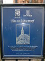
- Knockushion (NX 1850 9807). Also 'Knockcushan', this Knoll or Hill of Justice in GirvanGirvanGirvan is a burgh in Carrick, South Ayrshire, Scotland, with a population of about 8000 people. Originally a fishing port, it is now also a seaside resort with beaches and cliffs. Girvan dates back to 1668 when is became a municipal burgh incorporated by by charter...
was a Law or Court Hill. The existence of the mound is now marked by a modern pillar bearing the following inscription:-"Knockushion" (Hill of Justice) - From time immemorial the seat of the head - courts of the ancient jurisdiction of Carrick. King Robert the Bruce, Earl of Carrick, held court here and granted charter to the Friars of Ayre". The rest of the inscription is weathered away. No mound is visible at the site. 55.2433°N 4.8565°W Girvan's Stumpy TowerStumpy TowerStumpy Tower is a former gaol in Girvan, South Ayrshire, Scotland. It has been suggested that its popular name "Auld Stumpy" comes from the Gaelic Olladh Stiom Paidh, meaning "Great Circle of Justice"...
's name comes from the Gaelic “Olladh Stiom Paidh” and relates to the phrase "Great Circle of Justice" which is a similar meaning to Knockcushan Street, upon which the tower sits.
- Moat of Alloway. The Magistrates of Ayr appear from the records of the town to have frequently held Courts of Justice for the trial of petty cases, according to their charter, on its summit.
- Mote-hill. Helenton, near SymingtonSymington, South AyrshireSymington is a conservation village in South Ayrshire, Scotland. It is located in Symington Parish, covering 0.41sq Km, and lies close to the A77 road from Ayr to Glasgow...
. Barony of Helenton. Some ruins were present on its summit.
- Tarbolton Mote, Hoodshill or Torbol . Parish of Tarbolton. A fairly substantial mound on a natural prominence on the outskirts of the village. It is classified as a motte and bailey. The artificial mound is 10 feet (3 m) high, 25 yards (23 m) wide at the base and was the Court Hill of the Barony of Tarbolton. It was formerly called the Mote, but now is more frequently named Hoodshill, from a schoolmaster called Hood, whose pupils played on it. It is the only common attached to the village of Tarbolton, and a bonfire was lit on it annually on the night preceding the June Fair up until at least the 1860s. A Gallow Hill is situated nearby overlooking what was the old Coilsfield estate. Paterson records that the moot hill bonfire was built from fuel collected from every house and then placed on a circular altar or fire-place of turf. He states that Tarbolton translates as the town at the Hill where Baal was worshipped. The hall built on this mount was the chief messuage of the Barony, where seisin was invested.55.5146°N 4.4844°W
Borders
- Court Hill is marked on the OS map, lying close to Dawyck House near Stobo village.
Dumfries and Galloway
- Barnside Hill was the place of execution for the regalityRegalityA regality was a territorial jurisdiction in old Scots law which might be created by the King only, by granting lands to a subject in liberam regalitatem, and also the tract of land over which such a right extended....
and barony of Lag in Nithsdale. Sir Robert Grierson, as stated, was the last laird to try, condemn and execute a person in Nithsdale, circa 1697.
- Court Hill (NX 815 929). Parish of Tynron. A small hill where the Courts of the barony of Aird were held.55.2161°N 3.8641°W
- Court Hill (NX 3765 4275). Parish of GlassertonGlasserton‘’’Glasserton’’’ is a parish in Dumfries and Galloway, Scotland. It is thought that the name derives from the Saxon for “bare hill”. It is located near Whithorn and includes the village of Monrieth, the area called Kirkmaiden and two mansions, namely Glasserton Park and Physgill, together with...
. A considerable hill on the farm of Fell near MochrumMochrumMochrum is a small agricultural parish in Wigtownshire on the west of the Machars peninsula, Dumfries and Galloway, Scotland. It has a population of about 125 which is considerably lower than the population of about 150 years ago. It lies 3.1 km north of the small fishing village of Port...
, the site of the laird's dwelling before the Maxwells built Monreith House. Mr Cumming says that it has been handed down by tradition that a court of justice had been held here in ancient times by the Druids hence its name.54.7534°N 4.5242°W The Monreith Cross used to stand upon it until it was removed to Monreith House and finally to the WhithornWhithornWhithorn is a former royal burgh in Dumfries and Galloway, Scotland, about ten miles south of Wigtown. The town was the location of the first recorded Christian church in Scotland, Candida Casa : the 'White [or 'Shining'] House', built by Saint Ninian about 397.-Eighth and twelfth centuries:A...
Museum.
- Motte of Urr. The great judicial centre of the Kings of GallowayLords of GallowayThe Lords, or Kings of Galloway ruled over Galloway, in south west Scotland, for a large part of the High Middle Ages.Many regions of Scotland, including Galloway and Moray, periodically had kings or subkings, similar to those in Ireland during the Middle Ages. The Scottish monarch was seen as...
, covering the lands below the waters of the River CreeCreeThe Cree are one of the largest groups of First Nations / Native Americans in North America, with 200,000 members living in Canada. In Canada, the major proportion of Cree live north and west of Lake Superior, in Ontario, Manitoba, Saskatchewan, Alberta and the Northwest Territories, although...
.
- Tinwald (NY 0030 8151) - alternative Names: Tynwald; Motte Of Tinwald; Tinwald Motte; Tinwald Mote. A bailey or motte.55.1179°N 3.5647°W
East Dunbartonshire
- Mugdock Moot Hill - Prior to the early 18th century, the Moot Hill was an island on MugdockMugdock Country ParkMugdock Country Park is a country park and historical site located partly in East Dunbartonshire and partly in Stirling, in the former county of Stirlingshire, Scotland...
Loch. The loch was drained between 1710 and 1714 to claim land and construct avenues for the newly developing Craigend Estate. Gallowhill is nearby. Before 1747 prisoners of Mugdock Castle’s barony jail were rowed out to Moot Island for the trial, en-route to the gallows at Gallowhill if they were convicted. Gallowhill is located close to the Visitor Centre. In the SW trench the rock fell away quickly into deep peat deposits. A drystone revetment ran alongside the edge of the mound, which had been interpreted as a landing place or quay. Excavation and survey revealed that this was a stock-proof dyke, probably of 19th-century date. The island was renamed Moot Hill when the loch was drained and became a feature for residents and visitors to Craigend House as it was, and still is, situated close to the main avenue. Excavation work at Moot Hill carried out by Glasgow University in 2003 confirmed that Moot Hill is made of solid rock and has deposits of dark coloured peat covering it.
Fife
- Moat Hill - Cupar. The Burgh Survey states that, through the years, it has been known as Moot Hill, Mote Hill, Cam Hill and Mons Placiti. Sibbald noted in the 18th century that the word ‘‘cam’’ in Gaelic meant crooked and was very descriptive of the long, winding ridge of which Castle Hill formed a part. The Reporter in the Statistical Account of the Burgh suggested that it should have been styled Mote Hill as it was probably the place where the Justiciar of Fife had his courts and published his enactments.
Glasgow
- Doomster Hill - Parish of GovanGovanGovan is a district and former burgh now part of southwest City of Glasgow, Scotland. It is situated west of Glasgow city centre, on the south bank of the River Clyde, opposite the mouth of the River Kelvin and the district of Partick....
NS 554 658, a large earthen mound with a stepped profile and level summit. It stood near the river ClydeRiver ClydeThe River Clyde is a major river in Scotland. It is the ninth longest river in the United Kingdom, and the third longest in Scotland. Flowing through the major city of Glasgow, it was an important river for shipbuilding and trade in the British Empire....
, north of the present Govan Cross. It was removed in the early 19th-century and Reid's Dyeworks erected on the site. In 1996, a team from Channel 4's Time Team programme carried out a dig at the site. They suggested that it could be a 12th century Norman motte. The 'Doom' was the name given to the reading of the sentence of the court by the Deemster of the Baronial court. 55.8636°N 4.3121°W
Highland
- Court Hill (NH 7356 5762), RosemarkieRosemarkieRosemarkie is a village on the south coast of the Black Isle peninsula in northern Scotland.-Geography:Rosemarkie lies a quarter of a mile east of the town of Fortrose...
. An apparently artificial mound of nearly a circular form, and level on the top. It is probably where the manor courts were held. 57.5908°N 4.1168°W
- Courthill, Kishorn. A supposed moot-hill lies north of the burial-ground and chapel of Saint Donnan.
- Moot Hill, DingwallDingwallDingwall is a town and former royal burgh in the Highland council area of Scotland. It has a population of 5,026. It was formerly an east-coast harbor but now lies inland. Dingwall Castle was once the biggest castle north of Stirling. On the town's present-day outskirts lies Tulloch Castle, parts...
. The "D" of Dingwall is the Norse rune which represents the sound of "th", Dingwall being "thingvollr", the place of assembly of the Norse "thing" court. That court met on an earthen mound on a site which today is the Cromartie Car Park, adjacent to St Clement's kirkyard and the historic parish church of Dingwall.57.6077°N 4.42793°W
Moray
- Court Hillock (NJ 3815 6300), Upper Auchenreath. a cairn. Traditionally said to have been a hill of justice 57.6526°N 3.0380°W.
Perth and Kinross
- Court Hill (NO ), Parish of Auchtergaven. An earthen mound 40 ft (12 m) high, evidently artificial and traditionally the site of judicial courts held prior to 1745.56.4801°N 3.4997°W
- Gallow's Hill above Milling Farm on the western shore of the Lake of MenteithLake of MenteithThe Lake of Menteith , is a loch in Scotland, located on the Carse of Stirling, the flood plain of the upper reaches of the rivers Forth and Teith, upstream of Stirling. Until the early 19th century, the more usual Scottish name of Loch of Menteith was used...
. This bold knoll is supposed to have been the site of execution of the Earls of MenteithEarl of MenteithThe Mormaer or Earl of Menteith was originally the ruler of the province of Menteith in the Middle Ages. The first mormaer is usually regarded as Gille Críst, simply because he is the earliest on record. The title was held in a continuous line from Gille Crist until Muireadhach IV , although the...
. The last execution is said to have been of a young man; an unjust accusation having been leveled against him by the Earl of having stolen a horse.56°10′N 4°17′W
- Loak Court Hill (NO ). Parish of Auchergaven. A Barrow. An earthen mound 40 ft (12 m) high, evidently artificial and traditionally the site of judicial courts held prior to 1745.56.4801°N 3.4997°W
- Lonforgan or Hund Hill - Sir Patrick Gray as lord of the Barony of LongforganLongforganLongforgan is a village and parish in the Carse of Gowrie, in Perth and Kinross, Scotland. It lies west of Dundee on the main A90 road.-History:...
held a baronial court here in 1385. The officials present were the same as those at of the sovereign's courts.
- Moot Hill, StruanStruanStruan is a small village situated on the west coast of the island of Skye, on the shores of Loch Beag, itself an inlet of Loch Harport. "Struan" is the anglicized form of the Scottish Gaelic word sruthan, meaning "small stream", or the flow at the point where a spring appears.It has a...
. The assembly mound measures approx. 20 feet (6.1 m) high and is approx. 75 ft (22.9 m) in diameter across the base and 55 ft (16.8 m) across the top. It is generally held to be an early stronghold of the Chiefs of Clan Donnachaidh. A number of factors that suggest that it may be a moot.
- Mote-hill or Torran Mhoid in Scottish Gaelic. Balliemore, near Castle Roy. The title of Laird of Abernethy went with the possession of the moot hill and a story is told of one Earl of Moray who feued out all the other lands of Abernethy, but would not part with the moot hill, even if the top was covered with golden guineas. Another story tells of a Baron Baillie of Balliemore who took earth from the local churchyard and spread it onto his fields. He was persuaded to stop but later died from apoplexyApoplexyApoplexy is a medical term, which can be used to describe 'bleeding' in a stroke . Without further specification, it is rather outdated in use. Today it is used only for specific conditions, such as pituitary apoplexy and ovarian apoplexy. In common speech, it is used non-medically to mean a state...
whilst on the moot hill, because although he had stopped stealing the earth, he was still stealing it in his heart and God had punished him accordingly. There was a Drowning pool here where witches and female criminals were drowned.
- Prior's Meadow Mound at Port of Menteith. This small earth mound is supposed to have been formed from consecrated earth brought over from Ireland. This tradition may be linked to ColmanColmanColmán or Colman may refer to:-Medieval Irish people:* Colmán Bec , Irish dynast* Colmán mac Cobthaig , Irish king* Colmán mac Lénéni , Irish poet* Colmán Már , Irish dynast...
, the old Irish saint and bishop who gave his name to InchmahomeInchmahomeInchmahome, an anglicisation of Innis Mo Cholmaig , is the largest of three islands in the Lake of Menteith, in Stirlingshire.- History :...
island. This may have been the 'Hill of Justice' of the abbot who possessed baronial feudal rights.56°10′N 4°17′W
- Scone Moot Hill. The mons placiti or SconeScone, ScotlandScone is a village in Perth and Kinross, Scotland. The medieval village of Scone, which grew up around the monastery and royal residence, was abandoned in the early 19th century when the residents were removed and a new palace was built on the site by the Earl of Mansfield...
mote hill is the inauguration site of the Scottish Kings. It is also called 'Boot Hill', possibly from an ancient tradition whereby emissaries swore fealty to their king by wearing the earth of their own lands in their foot-bindings or boots.
East Renfrewshire
- Castle Hill, EagleshamEagleshamEaglesham , is a village and parish set in the west central Lowlands of Scotland - population 3,127 . Today it is chiefly a dormitory town for commuters to nearby Glasgow. The village is distinctive in being based around a large triangular green...
. Also known as the 'Deil's Planting'. The Moot Hill of the Barony of Eaglesham; a Gallowshill is located nearby. The Montgomerie family built Polnoon Castle and held the barony for several hundred years.
Ross and Cromarty
- Hill of Strife, UllinishUllinishUllinish is a crofting township on Loch Bracadale, on the southwest coast of Skye, Scotland. The only promontory fort on Skye is located at Ullinish. It is situated to the west of Struan and just south of the hamlet of Ebost. Historically, Ullinish is associated with the MacLeod family...
, Isle of Skye. Samuel Johnson was informed that this hill near Ulinish House was were justice used to be administered.
Stirling
- Court Hill, Duntreath, StrathblaneStrathblaneStrathblane is a village and parish in the registration county of Stirlingshire, situated in the southwestern part of the Stirling council area, in central Scotland. It lies at the foothills of the Campsie Fells and the Kilpatrick Hills on the Blane Water, north of Glasgow, east-southeast of...
. What used to be known as "the Court Hill," now Park Hill, rises on the east side of the Blane Valley. The top has been levelled, possibly for a fort, or a "mons placiti" or Moot Hill where courts of justice were held. The feudal privileges attached to Duntreath, indicate its importance.
Buckinghamshire
- Seclow Mound in Milton Keynes ( 52.0437°N 0.7606°W).
Cumbria
- Carlisle Moothill. Patrick Fraser TytlerPatrick Fraser TytlerPatrick Fraser Tytler was a Scottish historian.-Life:The son of Lord Woodhouselee, he was born in Edinburgh, where he attended the Royal High School. He was called to the bar in 1813; in 1816 he became King's counsel in the Exchequer, and practised as an advocate until 1832...
's History of Scotland, iv. 413, records that Lord Wharton, after his repulse in a raid up Nithsdale in 1547 held a Court at the Moothill beside Carlisle, and condemned ten of the Scottish "pledges" to be hanged.
Humberside
- RiseRise, East Riding of YorkshireRise is a village and civil parish in Holderness, the East Riding of Yorkshire, England. It is situated approximately east of the town of Beverley and south west of Hornsea. It lies to the east of the B1243 road....
, Yorkshire ( 53.8589°N 0.2590°W).
Northumberland
- Gallows Knowe, Berwick-upon-TweedBerwick-upon-TweedBerwick-upon-Tweed or simply Berwick is a town in the county of Northumberland and is the northernmost town in England, on the east coast at the mouth of the River Tweed. It is situated 2.5 miles south of the Scottish border....
( 55.7749°N 2.01145°W).
Nottinghamshire
- Spellow Hill, Radcliffe on TrentRadcliffe on TrentRadcliffe-on-Trent is a large village and civil parish in the Rushcliffe borough of Nottinghamshire-Location:Radcliffe has a population of around 8,000. It is to the east of Nottingham, and is close to but not quite part of the Greater Nottingham built-up area...
( 52.9545°N 1.0107°W).
Wiltshire
- Merlin's Mount. In the grounds of Marlborough CollegeMarlborough CollegeMarlborough College is a British co-educational independent school for day and boarding pupils, located in Marlborough, Wiltshire.Founded in 1843 for the education of the sons of Church of England clergy, the school now accepts both boys and girls of all beliefs. Currently there are just over 800...
. 51.416125°N 1.738239°W - Downton Moot
Isle of Man
- TynwaldTynwaldThe Tynwald , or more formally, the High Court of Tynwald is the legislature of the Isle of Man. It is claimed to be the oldest continuous parliamentary body in the world, consisting of the directly elected House of Keys and the indirectly chosen Legislative Council.The Houses sit jointly, for...
, St John's 54.202657°N 4.641350°W. This stepped structure is probably of great antiquity" and is nowadays thought originally to have been a burial mound of the Bronze Age. It is said to be formed of earth brought from each of the seventeen parishes of the Isle of ManIsle of ManThe Isle of Man , otherwise known simply as Mann , is a self-governing British Crown Dependency, located in the Irish Sea between the islands of Great Britain and Ireland, within the British Isles. The head of state is Queen Elizabeth II, who holds the title of Lord of Mann. The Lord of Mann is...
.