

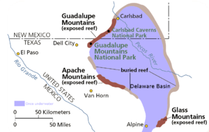
Delaware Basin
Encyclopedia
West Texas
West Texas is a vernacular term applied to a region in the southwestern quadrant of the United States that primarily encompasses the arid and semi-arid lands in the western portion of the state of Texas....
and southern New Mexico
New Mexico
New Mexico is a state located in the southwest and western regions of the United States. New Mexico is also usually considered one of the Mountain States. With a population density of 16 per square mile, New Mexico is the sixth-most sparsely inhabited U.S...
is famous for holding large oil fields and for exposing a fossilized reef. Guadalupe Mountains National Park
Guadalupe Mountains National Park
Guadalupe Mountains National Park is located in the Guadalupe Mountains of West Texas and contains Guadalupe Peak, the highest point in Texas at in elevation. It also contains El Capitan, long used as a landmark by people traveling along the old route later followed by the Butterfield Overland...
and Carlsbad Caverns National Park
Carlsbad Caverns National Park
Carlsbad Caverns National Park is a United States National Park in the Guadalupe Mountains in southeastern New Mexico. The primary attraction of the park for most visitors is the show cave, Carlsbad Caverns...
protect part of the basin. It is part of the larger Permian Basin, itself part of the Mid-Continent Oil Field
Mid-continent Oil Field
The Mid-continent oil field is a broad area containing hundreds of oil fields in Arkansas, Kansas, Louisiana, New Mexico, Oklahoma and Texas. The area, which consists of various geological strata and diverse trap types, was discovered and exploited during the first half of the 20th century...
.
Geology
By earliest PermianPermian
The PermianThe term "Permian" was introduced into geology in 1841 by Sir Sir R. I. Murchison, president of the Geological Society of London, who identified typical strata in extensive Russian explorations undertaken with Edouard de Verneuil; Murchison asserted in 1841 that he named his "Permian...
time, during the Wolfcampian epoch, the ovoid shaped subsiding Delaware Basin extended over 10,000 square miles (26,000 km²) in what is now western Texas
Texas
Texas is the second largest U.S. state by both area and population, and the largest state by area in the contiguous United States.The name, based on the Caddo word "Tejas" meaning "friends" or "allies", was applied by the Spanish to the Caddo themselves and to the region of their settlement in...
. This period of deposition left a thickness of 1600 to 2200 feet (490 to 670 m) of limestone
Limestone
Limestone is a sedimentary rock composed largely of the minerals calcite and aragonite, which are different crystal forms of calcium carbonate . Many limestones are composed from skeletal fragments of marine organisms such as coral or foraminifera....
interbedded with dark-colored shale
Shale
Shale is a fine-grained, clastic sedimentary rock composed of mud that is a mix of flakes of clay minerals and tiny fragments of other minerals, especially quartz and calcite. The ratio of clay to other minerals is variable. Shale is characterized by breaks along thin laminae or parallel layering...
.
A narrow outlet that geologists call the Hovey Channel periodically supplied new seawater
Seawater
Seawater is water from a sea or ocean. On average, seawater in the world's oceans has a salinity of about 3.5% . This means that every kilogram of seawater has approximately of dissolved salts . The average density of seawater at the ocean surface is 1.025 g/ml...
from the Panthalassa Ocean
Panthalassa
Panthalassa , also known as the Panthalassic Ocean, was the vast global ocean that surrounded the supercontinent Pangaea, during the late Paleozoic and the early Mesozoic years. It included the Pacific Ocean to the west and north and the Tethys Ocean to the southeast...
to the west. The somewhat smaller and shallower Midland Basin was just east and the much smaller Marfa Basin was to the southwest. All three basins were south of the equator
Equator
An equator is the intersection of a sphere's surface with the plane perpendicular to the sphere's axis of rotation and containing the sphere's center of mass....
, north of the Ouachita Mountains
Ouachita Mountains
The Ouachita Mountains are a mountain range in west central Arkansas and southeastern Oklahoma. The range's subterranean roots may extend as far as central Texas, or beyond it to the current location of the Marathon Uplift. Along with the Ozark Mountains, the Ouachita Mountains form the U.S...
of mid-Texas, and part of the northern continent Laurasia
Laurasia
In paleogeography, Laurasia was the northernmost of two supercontinents that formed part of the Pangaea supercontinent from approximately...
. Structurally the Delaware, Midland and Marfa were foreland basins created when the Ouachita Mountains were uplifted as the southern continent Gondwana
Gondwana
In paleogeography, Gondwana , originally Gondwanaland, was the southernmost of two supercontinents that later became parts of the Pangaea supercontinent. It existed from approximately 510 to 180 million years ago . Gondwana is believed to have sutured between ca. 570 and 510 Mya,...
collided with Laurasia, forming the supercontinent Pangea in the Late Carboniferous
Carboniferous
The Carboniferous is a geologic period and system that extends from the end of the Devonian Period, about 359.2 ± 2.5 Mya , to the beginning of the Permian Period, about 299.0 ± 0.8 Mya . The name is derived from the Latin word for coal, carbo. Carboniferous means "coal-bearing"...
(Pennsylvanian
Pennsylvanian
The Pennsylvanian is, in the ICS geologic timescale, the younger of two subperiods of the Carboniferous Period. It lasted from roughly . As with most other geochronologic units, the rock beds that define the Pennsylvanian are well identified, but the exact date of the start and end are uncertain...
). The Ouachita Mountains formed a rainshadow over the basins, and a warm shallow sea flooded the surrounding area. On the other side of the equator, the Ancestral Rocky Mountains formed a large mountainous island
Island
An island or isle is any piece of sub-continental land that is surrounded by water. Very small islands such as emergent land features on atolls can be called islets, cays or keys. An island in a river or lake may be called an eyot , or holm...
.
The Delaware Basin temporarily stopped subsiding in the Leonardian epoch at the start of the mid-Permian
Permian
The PermianThe term "Permian" was introduced into geology in 1841 by Sir Sir R. I. Murchison, president of the Geological Society of London, who identified typical strata in extensive Russian explorations undertaken with Edouard de Verneuil; Murchison asserted in 1841 that he named his "Permian...
. Small banks along its margin developed along with small discontinuous patch reef
Reef
In nautical terminology, a reef is a rock, sandbar, or other feature lying beneath the surface of the water ....
s in the shallow water just offshore. The first formation that resulted was the Yeso and consists of alternating beds of dolomite limestone, gypsum
Gypsum
Gypsum is a very soft sulfate mineral composed of calcium sulfate dihydrate, with the chemical formula CaSO4·2H2O. It is found in alabaster, a decorative stone used in Ancient Egypt. It is the second softest mineral on the Mohs Hardness Scale...
, and sandstone
Sandstone
Sandstone is a sedimentary rock composed mainly of sand-sized minerals or rock grains.Most sandstone is composed of quartz and/or feldspar because these are the most common minerals in the Earth's crust. Like sand, sandstone may be any colour, but the most common colours are tan, brown, yellow,...
. The sediments responsible for creating the Yeso were deposited in nearshore areas that graded into the carbonate banks of the Victorio Peak Formation in the deeper waters. Thin-bedded limestones of the Bone Spring Formation accumulated as limy ooze in the stagnant deepest part of the basin.
Subsidence of the Delaware Basin restarted later in the mid Permian and by the Guadalupian epoch of the upper Permian the patch reefs had grown larger. Sediments deposited close to the shore are now the chert
Chert
Chert is a fine-grained silica-rich microcrystalline, cryptocrystalline or microfibrous sedimentary rock that may contain small fossils. It varies greatly in color , but most often manifests as gray, brown, grayish brown and light green to rusty red; its color is an expression of trace elements...
y dolomites of the San Andres Formation while deposition a little further out forms the quartz
Quartz
Quartz is the second-most-abundant mineral in the Earth's continental crust, after feldspar. It is made up of a continuous framework of SiO4 silicon–oxygen tetrahedra, with each oxygen being shared between two tetrahedra, giving an overall formula SiO2. There are many different varieties of quartz,...
sandstone and scattered patch reefs of the Brushy Canyon Formation.
Rapid subsidence of the basin started in the middle Guadalupian. Patch reefs responded by rapid (mostly vertical) growth, resulting in the Goat Seep Reef. Three facies
Facies
In geology, facies are a body of rock with specified characteristics. Ideally, a facies is a distinctive rock unit that forms under certain conditions of sedimentation, reflecting a particular process or environment....
developed:
- SedimentSedimentSediment is naturally occurring material that is broken down by processes of weathering and erosion, and is subsequently transported by the action of fluids such as wind, water, or ice, and/or by the force of gravity acting on the particle itself....
s deposited in a lagoonLagoonA lagoon is a body of shallow sea water or brackish water separated from the sea by some form of barrier. The EU's habitat directive defines lagoons as "expanses of shallow coastal salt water, of varying salinity or water volume, wholly or partially separated from the sea by sand banks or shingle,...
, forming the sandstones and dolomites of the Queen and Grayburg Formations. - SpongeSea spongeSponges are animals of the phylum Porifera . Their bodies consist of jelly-like mesohyl sandwiched between two thin layers of cells. While all animals have unspecialized cells that can transform into specialized cells, sponges are unique in having some specialized cells, but can also have...
and algaeAlgaeAlgae are a large and diverse group of simple, typically autotrophic organisms, ranging from unicellular to multicellular forms, such as the giant kelps that grow to 65 meters in length. They are photosynthetic like plants, and "simple" because their tissues are not organized into the many...
skeletonSkeletonThe skeleton is the body part that forms the supporting structure of an organism. There are two different skeletal types: the exoskeleton, which is the stable outer shell of an organism, and the endoskeleton, which forms the support structure inside the body.In a figurative sense, skeleton can...
s accumulated near the Goat Seep Reef to become the Getaway Bank. - Quartz sandSandSand is a naturally occurring granular material composed of finely divided rock and mineral particles.The composition of sand is highly variable, depending on the local rock sources and conditions, but the most common constituent of sand in inland continental settings and non-tropical coastal...
laid down further in the basin became the Cherry Canyon Formation.
Subsidence of the basin stopped for good by the later part of the Guadalupian. Capitan Reef was the largest in the basin, and it rapidly grew 350 miles (560 km) around it. The facies were:
- Fine-grained sand and carbonateCarbonateIn chemistry, a carbonate is a salt of carbonic acid, characterized by the presence of the carbonate ion, . The name may also mean an ester of carbonic acid, an organic compound containing the carbonate group C2....
s deposited near the shore became the dolomites and sandstone of the Carlsbad Group. - Offshore accumulations of sand and limey ooze in the basin were lithified into sandstone and limestone belonging to the Bell Canyon Formation.
- The Capitan Formation consists of Capitan Reef and is made of reef limestone.
Capitan Reef was built primarily from calcareous sponges, encrusting algae such as stromatolite
Stromatolite
Stromatolites or stromatoliths are layered accretionary structures formed in shallow water by the trapping, binding and cementation of sedimentary grains by biofilms of microorganisms, especially cyanobacteria ....
s, and directly from seawater as a limey mud. In stark contrast, Cenozoic
Cenozoic
The Cenozoic era is the current and most recent of the three Phanerozoic geological eras and covers the period from 65.5 mya to the present. The era began in the wake of the Cretaceous–Tertiary extinction event at the end of the Cretaceous that saw the demise of the last non-avian dinosaurs and...
(current era), Mesozoic
Mesozoic
The Mesozoic era is an interval of geological time from about 250 million years ago to about 65 million years ago. It is often referred to as the age of reptiles because reptiles, namely dinosaurs, were the dominant terrestrial and marine vertebrates of the time...
(age of the Dinosaur
Dinosaur
Dinosaurs are a diverse group of animals of the clade and superorder Dinosauria. They were the dominant terrestrial vertebrates for over 160 million years, from the late Triassic period until the end of the Cretaceous , when the Cretaceous–Paleogene extinction event led to the extinction of...
s), and even middle Paleozoic
Paleozoic
The Paleozoic era is the earliest of three geologic eras of the Phanerozoic eon, spanning from roughly...
(well before the Permian) reefs are mainly composed of coral
Coral
Corals are marine animals in class Anthozoa of phylum Cnidaria typically living in compact colonies of many identical individual "polyps". The group includes the important reef builders that inhabit tropical oceans and secrete calcium carbonate to form a hard skeleton.A coral "head" is a colony of...
s.
Sea level
Sea level
Mean sea level is a measure of the average height of the ocean's surface ; used as a standard in reckoning land elevation...
dropped as the late Permian glaciation intensified and locked increasing amounts of water in distant ice cap
Ice cap
An ice cap is an ice mass that covers less than 50 000 km² of land area . Masses of ice covering more than 50 000 km² are termed an ice sheet....
s. Sedimentation continued to fill the Delaware Basin into the Ochoan epoch
Ochoan epoch
The Ochoan is a stage in the Permian stratigraphy of North America. The Ochoan age is roughly simultaneous with the Changhsingian age in the timescale of the ICS. This post-Guadalupian stage is known for high levels of evaporite deposits....
of the upper Permian, periodically cutting the basin off from its source of seawater. Part of the resulting brine
Brine
Brine is water, saturated or nearly saturated with salt .Brine is used to preserve vegetables, fruit, fish, and meat, in a process known as brining . Brine is also commonly used to age Halloumi and Feta cheeses, or for pickling foodstuffs, as a means of preserving them...
became the deep-water evaporite
Evaporite
Evaporite is a name for a water-soluble mineral sediment that result from concentration and crystallization by evaporation from an aqueous solution. There are two types of evaporate deposits, marine which can also be described as ocean deposits, and non-marine which are found in standing bodies of...
s of the Castile Formation. The Castile consists of 1/16 inch (1.6 mm) thick laminae of alternating gray anhydrite
Anhydrite
Anhydrite is a mineral – anhydrous calcium sulfate, CaSO4. It is in the orthorhombic crystal system, with three directions of perfect cleavage parallel to the three planes of symmetry. It is not isomorphous with the orthorhombic barium and strontium sulfates, as might be expected from the...
and gypsum
Gypsum
Gypsum is a very soft sulfate mineral composed of calcium sulfate dihydrate, with the chemical formula CaSO4·2H2O. It is found in alabaster, a decorative stone used in Ancient Egypt. It is the second softest mineral on the Mohs Hardness Scale...
, brown calcite
Calcite
Calcite is a carbonate mineral and the most stable polymorph of calcium carbonate . The other polymorphs are the minerals aragonite and vaterite. Aragonite will change to calcite at 380-470°C, and vaterite is even less stable.-Properties:...
, and halite
Halite
Halite , commonly known as rock salt, is the mineral form of sodium chloride . Halite forms isometric crystals. The mineral is typically colorless or white, but may also be light blue, dark blue, purple, pink, red, orange, yellow or gray depending on the amount and type of impurities...
. As the salt concentration increased, halite and potassium
Potassium
Potassium is the chemical element with the symbol K and atomic number 19. Elemental potassium is a soft silvery-white alkali metal that oxidizes rapidly in air and is very reactive with water, generating sufficient heat to ignite the hydrogen emitted in the reaction.Potassium and sodium are...
-rich salt
Salt
In chemistry, salts are ionic compounds that result from the neutralization reaction of an acid and a base. They are composed of cations and anions so that the product is electrically neutral...
precipitated from the briny body of water on its margin and on nearshore areas. This salt layer covered an increasingly large area as the water level dropped, forming the Salado Formation.
Delaware Basin was filled at least to the top of Capitan Reef and mostly covered by dry land before the end of the Ochoan epoch. Rivers migrated over its surface and deposited the red silt and sand that now constitute the siltstone
Siltstone
Siltstone is a sedimentary rock which has a grain size in the silt range, finer than sandstone and coarser than claystones.- Description :As its name implies, it is primarily composed of silt sized particles, defined as grains 1/16 - 1/256 mm or 4 to 8 on the Krumbein phi scale...
and sandstone of the Rustler and Dewey Lake Formations. A Karst topography
Karst topography
Karst topography is a geologic formation shaped by the dissolution of a layer or layers of soluble bedrock, usually carbonate rock such as limestone or dolomite, but has also been documented for weathering resistant rocks like quartzite given the right conditions.Due to subterranean drainage, there...
developed as groundwater
Groundwater
Groundwater is water located beneath the ground surface in soil pore spaces and in the fractures of rock formations. A unit of rock or an unconsolidated deposit is called an aquifer when it can yield a usable quantity of water. The depth at which soil pore spaces or fractures and voids in rock...
circulated in the buried limestone formations, dissolving away caves and underground caverns which were later destroyed by infill and erosion.
Uplift associated with the Laramide orogeny
Laramide orogeny
The Laramide orogeny was a period of mountain building in western North America, which started in the Late Cretaceous, 70 to 80 million years ago, and ended 35 to 55 million years ago. The exact duration and ages of beginning and end of the orogeny are in dispute, as is the cause. The Laramide...
in the late Mesozoic
Mesozoic
The Mesozoic era is an interval of geological time from about 250 million years ago to about 65 million years ago. It is often referred to as the age of reptiles because reptiles, namely dinosaurs, were the dominant terrestrial and marine vertebrates of the time...
and early Cenozoic
Cenozoic
The Cenozoic era is the current and most recent of the three Phanerozoic geological eras and covers the period from 65.5 mya to the present. The era began in the wake of the Cretaceous–Tertiary extinction event at the end of the Cretaceous that saw the demise of the last non-avian dinosaurs and...
created a major fault along which the Guadalupe Mountains
Guadalupe Mountains
The Guadalupe Mountains are a mountain range located in West Texas and southeastern New Mexico. The range includes the highest summit in Texas, Guadalupe Peak, , and the "signature peak" of West Texas, El Capitan, both located within Guadalupe Mountains National Park, as well as Carlsbad Caverns...
were thrusted into existence. The range forms the tilted upthrown part of the system and the Salt Flat Bolson forms the downfallen block. Capitan Reef limestone was exposed above the surface with the 1000 foot (300 m) high El Capitan
El Capitan (Texas)
El Capitan is a peak in Culberson County, Texas, USA, within Guadalupe Mountains National Park. It is the eighth-highest peak in Texas, and rises abruptly out of the Chihuahuan Desert floor; it is considered the "signature peak" of West Texas....
being its most prominent feature. Other large outcrops compose the Apache Mountains and Glass Mountains to the south.
Stream
Stream
A stream is a body of water with a current, confined within a bed and stream banks. Depending on its locale or certain characteristics, a stream may be referred to as a branch, brook, beck, burn, creek, "crick", gill , kill, lick, rill, river, syke, bayou, rivulet, streamage, wash, run or...
s eroded the softer sediment away, lowering the ground level to its current position. Acidic groundwater
Groundwater
Groundwater is water located beneath the ground surface in soil pore spaces and in the fractures of rock formations. A unit of rock or an unconsolidated deposit is called an aquifer when it can yield a usable quantity of water. The depth at which soil pore spaces or fractures and voids in rock...
excavated cave
Cave
A cave or cavern is a natural underground space large enough for a human to enter. The term applies to natural cavities some part of which is in total darkness. The word cave also includes smaller spaces like rock shelters, sea caves, and grottos.Speleology is the science of exploration and study...
s in the limestone of the higher areas and eroded sediment helped fill any remaining Permian-aged caves. Unlike most other caves in limestone, in this case the acid
Acid
An acid is a substance which reacts with a base. Commonly, acids can be identified as tasting sour, reacting with metals such as calcium, and bases like sodium carbonate. Aqueous acids have a pH of less than 7, where an acid of lower pH is typically stronger, and turn blue litmus paper red...
was likely derived from hydrogen sulfide
Hydrogen sulfide
Hydrogen sulfide is the chemical compound with the formula . It is a colorless, very poisonous, flammable gas with the characteristic foul odor of expired eggs perceptible at concentrations as low as 0.00047 parts per million...
and sulfide
Sulfide
A sulfide is an anion of sulfur in its lowest oxidation state of 2-. Sulfide is also a slightly archaic term for thioethers, a common type of organosulfur compound that are well known for their bad odors.- Properties :...
-rich brines that were freed by tectonic activity in the mid-Tertiary
Tertiary
The Tertiary is a deprecated term for a geologic period 65 million to 2.6 million years ago. The Tertiary covered the time span between the superseded Secondary period and the Quaternary...
and mixed with oxygen
Oxygen
Oxygen is the element with atomic number 8 and represented by the symbol O. Its name derives from the Greek roots ὀξύς and -γενής , because at the time of naming, it was mistakenly thought that all acids required oxygen in their composition...
ated groundwater, forming sulfuric acid
Sulfuric acid
Sulfuric acid is a strong mineral acid with the molecular formula . Its historical name is oil of vitriol. Pure sulfuric acid is a highly corrosive, colorless, viscous liquid. The salts of sulfuric acid are called sulfates...
. Carlsbad Caverns and nearby modern caves started to form at this time in the groundwater
Groundwater
Groundwater is water located beneath the ground surface in soil pore spaces and in the fractures of rock formations. A unit of rock or an unconsolidated deposit is called an aquifer when it can yield a usable quantity of water. The depth at which soil pore spaces or fractures and voids in rock...
-saturated (phreatic)
Phreatic zone
The phreatic zone, or zone of saturation, is the area in an aquifer, below the water table, in which relatively all pores and fractures are saturated with water. The phreatic zone may fluctuate with changes of season and during wet and dry periods....
zone. Due to the semiarid climate
Climate
Climate encompasses the statistics of temperature, humidity, atmospheric pressure, wind, rainfall, atmospheric particle count and other meteorological elemental measurements in a given region over long periods...
, the karst topography that was created lacks the characteristic depressions, sink holes, pits, and solutional fissures on the surface. Mass wasting
Mass wasting
Mass wasting, also known as slope movement or mass movement, is the geomorphic process by which soil, regolith, and rock move downslope under the force of gravity. Types of mass wasting include creep, slides, flows, topples, and falls, each with its own characteristic features, and taking place...
such as landslide
Landslide
A landslide or landslip is a geological phenomenon which includes a wide range of ground movement, such as rockfalls, deep failure of slopes and shallow debris flows, which can occur in offshore, coastal and onshore environments...
s further reduced topographic relief.
Additional uplift of the Guadalupe Mountains in the Pliocene
Pliocene
The Pliocene Epoch is the period in the geologic timescale that extends from 5.332 million to 2.588 million years before present. It is the second and youngest epoch of the Neogene Period in the Cenozoic Era. The Pliocene follows the Miocene Epoch and is followed by the Pleistocene Epoch...
and early Pleistocene
Pleistocene
The Pleistocene is the epoch from 2,588,000 to 11,700 years BP that spans the world's recent period of repeated glaciations. The name pleistocene is derived from the Greek and ....
epochs enlarged Carlsbad Cavern and nearby caves. Parts of the major caves emerged from the saturated phreatic zone
Phreatic zone
The phreatic zone, or zone of saturation, is the area in an aquifer, below the water table, in which relatively all pores and fractures are saturated with water. The phreatic zone may fluctuate with changes of season and during wet and dry periods....
into the vadose with temporary periods of repose during which additional solution
Solution
In chemistry, a solution is a homogeneous mixture composed of only one phase. In such a mixture, a solute is dissolved in another substance, known as a solvent. The solvent does the dissolving.- Types of solutions :...
al excavation occurred in the phreatic zone. These pauses in emergence are thought to be responsible for creating the different levels in Carlsbad Caverns. Precipitation of carbon dioxide
Carbon dioxide
Carbon dioxide is a naturally occurring chemical compound composed of two oxygen atoms covalently bonded to a single carbon atom...
-rich water that infiltrated into the cavern created speleothem
Speleothem
A speleothem , commonly known as a cave formation, is a secondary mineral deposit formed in a cave. Speleothems are typically formed in limestone or dolostone solutional caves.-Origin and composition:...
s, especially in the humid
Humidity
Humidity is a term for the amount of water vapor in the air, and can refer to any one of several measurements of humidity. Formally, humid air is not "moist air" but a mixture of water vapor and other constituents of air, and humidity is defined in terms of the water content of this mixture,...
parts of the Pleistocene. Speleothems found in the "Big Room" of Carlsbad were dated using electron-spin resonance dating and were found to be 500,000 to 600,000 years old. This indicates that the Big Room level was dry by that time.
The soft and easily-eroded gypsum of the Castile Formation was removed, exposing the Guadalupe Escarpment. Additional erosion intersected the upper part of Carlsbad Cavern and other caves, forming their entrances. Drying of cave air has reduced the growth rate of speleothems, stalactite
Stalactite
A stalactite , "to drip", and meaning "that which drips") is a type of speleothem that hangs from the ceiling of limestone caves. It is a type of dripstone...
s, and stalagmite
Stalagmite
A stalagmite is a type of speleothem that rises from the floor of a limestone cave due to the dripping of mineralized solutions and the deposition of calcium carbonate. This stalagmite formation occurs only under certain pH conditions within the underground cavern. The corresponding formation on...
s and encouraged the development of nodular travertine
Travertine
Travertine is a form of limestone deposited by mineral springs, especially hot springs. Travertine often has a fibrous or concentric appearance and exists in white, tan, and cream-colored varieties. It is formed by a process of rapid precipitation of calcium carbonate, often at the mouth of a hot...
("cave popcorn").
See also
- List of geographical regions in Texas
- El Capitan (Texas)El Capitan (Texas)El Capitan is a peak in Culberson County, Texas, USA, within Guadalupe Mountains National Park. It is the eighth-highest peak in Texas, and rises abruptly out of the Chihuahuan Desert floor; it is considered the "signature peak" of West Texas....
- McKittrick CanyonMcKittrick CanyonMcKittrick Canyon is a scenic canyon within the Guadalupe Mountains of West Texas. The steep towering walls of McKittrick Canyon protect a rich riparian oasis in the midst of the Chihuahuan Desert....
- Chihuahuan DesertChihuahuan DesertThe Chihuahuan Desert is a desert, and an ecoregion designation, that straddles the U.S.-Mexico border in the central and northern portions of the Mexican Plateau, bordered on the west by the extensive Sierra Madre Occidental range, and overlaying northern portions of the east range, the Sierra...
- West TexasWest TexasWest Texas is a vernacular term applied to a region in the southwestern quadrant of the United States that primarily encompasses the arid and semi-arid lands in the western portion of the state of Texas....