
Guadalupe Mountains
Encyclopedia
The Guadalupe Mountains are a mountain range
located in West Texas
and southeastern New Mexico
. The range includes the highest summit in Texas, Guadalupe Peak
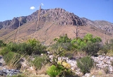
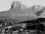
, 8749 ft (2,667 m), and the "signature peak" of West Texas
, El Capitan
, both located within Guadalupe Mountains National Park
, as well as Carlsbad Caverns National Park
. The Guadalupe Mountains are surrounded by the South Plains
to the east and north, Delaware Mountains to the south, and Sacramento Mountains
to the west.
 Throughout the last thousands of years, the Guadalupe Mountains have a long tumultuous history. Archaeological evidence has shown that people lived over 10,000 years ago in and among the many caves and alcoves. The first humans to live here were hunter-gathers that followed large game and collected edible vegetation. Artifacts that support this include projectile points, baskets, pottery, and rock art.
The first Europeans to arrive in the area were the Spanish
in the 16th century, but they did not make serious attempts to settle in the Guadalupe Mountains. The Spanish introduced horses into the area; and nomadic indigenous tribes of the area like the Apaches soon found horses to be an asset for hunting and migrating. Mescalero Apaches were nomadic and followed game and harvested the agave (or mescal) for food and fiber. Mescalero is Spanish for mescal-maker. Agave roasting pits and other artifacts of Mescalero culture can be found in the park.
The Mescalero Apaches remained in the mountains through the mid-19th century, but they were challenged by an American transportation route at the end of the American Civil War
. During the 1840s and 1850s many people immigrating west crossed the area. In 1858, Pinery station was constructed near Pine Springs for the Butterfield Overland Mail
. The Butterfield Overland Mail traveled over Guadalupe Pass located at 5534 ft (1,686.8 m) above sea level. A Cavalry known as the Buffalo Soldiers were ordered to the area to stop indian raids on settlements and mail stage route. During the winter of 1869, Lt. H.B. Cushing led his troops into the Guadalupe Mountains and destroyed two Mescalero Apache camps and were eventually driven out of the area and into US indian reservations.
Felix McKittrick was one of the first European settlers in the Guadalupe Mountains; he worked cattle during the 1870s. McKittrick Canyon
is thought to be named after him. Frijole Ranch was the first permanent ranch house; it was constructed in 1876 by the Rader brothers. Frijole Ranch House was the only major building in the region; it served as a community center and regional post office from 1916-1942. Today, the Frijole Ranch House has been restored and operates as a cultural museum. In 1908 Williams Ranch House was built, and it was named after one of its inhabitants, James Adolphus Williams. Judge J.C. Hunter from Van Horn
, Texas
consolidated most of the smaller ranches in the area into the Guadalupe Mountain Ranch. In 1921, Wallace Pratt
, a geologist for Humble Oil and Refining Company, was impressed by the beauty of McKittrick Canyon
and bought the land to build two homes in the canyon. Both constructions were used as summer homes by Pratt and his family up until 1960. Wallace Pratt donated about 6000 acres (24.3 km²) of McKittrick Canyon which became part of Guadalupe Mountains National Park
, with an elevation of 8751 feet (2,667 m). The range lies southeast of the Sacramento Mountains
and east of the Brokeoff Mountains. The mountain range extends north-northwest and northeast from Guadalupe Peak in Texas into New Mexico. The northeastern extension ends about 10 miles (16 km) southwest of Carlsbad
, near White's City and Carlsbad Caverns National Park
; the southwest tip ends with El Capitan
about 90 miles (144.8 km) east of El Paso
. The mountains rise more than 3000 feet (914.4 m) above the arid floor of the Chihuahuan Desert
. with an elevation of 8751 feet (2,667 m). he Guadalupe Mountains are surrounded by the South Plains
to the east and north, Delaware Mountains to the south, and Sacramento Mountains
to the west.
The northwestern extension, bounded by a dramatic escarpment known as "The Rim", extends much further into New Mexico, to near the Sacramento Mountains. The range is bounded on the north by Four Mile Canyon; on the east by the valley of the Pecos River
; and on the west by Piñon Creek, Big Dog Canyon, Valley Canyon, Middle Dog Canyon and West Dog Canyon. Much of the range is built from the ancient Capitán Reef that formed at the margins of a shallow sea during the Permian Period. For detail on the area's geology, see Delaware Basin
. As the range is built up almost entirely of limestone
, upland areas have little or no surface water. The only significant surface water is McKittrick Creek, in McKittrick Canyon
, which emerges from the eastern side of the massif, just south of the New Mexico border. Elevations at the base of the range vary from 4000 feet (1,219.2 m) above sea level
on the western side to 5000 feet (1,524 m) on the east. Several peaks on the southern end exceed 8000 feet (2,438.4 m).
The Guadalupe Mountains experience relatively hot summers, calm, mild autumn weather, and cool to cold weather in winter and early spring. Snow storms, freezing rain, or fog may occur in winter or early spring. Frequent high wind warnings are issued during winter through spring. Late summer monsoons produce thunderstorms. Cool nights, even in summer.
desert
, with low elevations on the east covered with grassland
, pinyon pine
and juniper
s such as alligator juniper
and one-seeded juniper
. Secondly, canyon interiors such as McKittrick
, Bear, and Pine Springs Canyon on the southeast end exhibit maple
, ash, chinquapin oak, and other deciduous trees. These trees are able to grow in the desert due to springs of water recharged by wet uplands. Finally, alpine uplands known as 'The Bowl' exceeding elevations of 7000 ft (2,133.6 m) are clothed with denser forests of ponderosa pine
, southwestern white pine, and douglas-fir
, with small stands of aspen
.
The range contains many world-class cave
s, including Carlsbad Caverns (the best known) and Lechuguilla Cave
, discovered in 1986. The history of the range includes occupation by ancient Pueblo
and Mogollon peoples, and by the Apache
and various Anglo
outlaws in the 19th century.
Mountain range
A mountain range is a single, large mass consisting of a succession of mountains or narrowly spaced mountain ridges, with or without peaks, closely related in position, direction, formation, and age; a component part of a mountain system or of a mountain chain...
located in West Texas
West Texas
West Texas is a vernacular term applied to a region in the southwestern quadrant of the United States that primarily encompasses the arid and semi-arid lands in the western portion of the state of Texas....
and southeastern New Mexico
New Mexico
New Mexico is a state located in the southwest and western regions of the United States. New Mexico is also usually considered one of the Mountain States. With a population density of 16 per square mile, New Mexico is the sixth-most sparsely inhabited U.S...
. The range includes the highest summit in Texas, Guadalupe Peak
Guadalupe Peak
Guadalupe Peak is the highest natural point in Texas, with an elevation of . It is located in Guadalupe Mountains National Park, and is part of the Guadalupe Mountains range in southeastern New Mexico and West Texas. The mountain is about east of El Paso and about southwest of Carlsbad, New Mexico...
, 8749 ft (2,667 m), and the "signature peak" of West Texas
West Texas
West Texas is a vernacular term applied to a region in the southwestern quadrant of the United States that primarily encompasses the arid and semi-arid lands in the western portion of the state of Texas....
, El Capitan
El Capitan (Texas)
El Capitan is a peak in Culberson County, Texas, USA, within Guadalupe Mountains National Park. It is the eighth-highest peak in Texas, and rises abruptly out of the Chihuahuan Desert floor; it is considered the "signature peak" of West Texas....
, both located within Guadalupe Mountains National Park
Guadalupe Mountains National Park
Guadalupe Mountains National Park is located in the Guadalupe Mountains of West Texas and contains Guadalupe Peak, the highest point in Texas at in elevation. It also contains El Capitan, long used as a landmark by people traveling along the old route later followed by the Butterfield Overland...
, as well as Carlsbad Caverns National Park
Carlsbad Caverns National Park
Carlsbad Caverns National Park is a United States National Park in the Guadalupe Mountains in southeastern New Mexico. The primary attraction of the park for most visitors is the show cave, Carlsbad Caverns...
. The Guadalupe Mountains are surrounded by the South Plains
South Plains
South Plains is a vernacular term that refers to a region in West Texas consisting of the portion of the Llano Estacado extending south of the Texas Panhandle, centered at Lubbock. While prominent in the area of petroleum production, the South Plains is mainly an agricultural region, producing a...
to the east and north, Delaware Mountains to the south, and Sacramento Mountains
Sacramento Mountains
The Sacramento Mountains are a mountain range in the south-central part of the U.S. state of New Mexico, lying just east of Alamogordo in Otero County...
to the west.
History
The first Europeans to arrive in the area were the Spanish
Spain
Spain , officially the Kingdom of Spain languages]] under the European Charter for Regional or Minority Languages. In each of these, Spain's official name is as follows:;;;;;;), is a country and member state of the European Union located in southwestern Europe on the Iberian Peninsula...
in the 16th century, but they did not make serious attempts to settle in the Guadalupe Mountains. The Spanish introduced horses into the area; and nomadic indigenous tribes of the area like the Apaches soon found horses to be an asset for hunting and migrating. Mescalero Apaches were nomadic and followed game and harvested the agave (or mescal) for food and fiber. Mescalero is Spanish for mescal-maker. Agave roasting pits and other artifacts of Mescalero culture can be found in the park.
The Mescalero Apaches remained in the mountains through the mid-19th century, but they were challenged by an American transportation route at the end of the American Civil War
American Civil War
The American Civil War was a civil war fought in the United States of America. In response to the election of Abraham Lincoln as President of the United States, 11 southern slave states declared their secession from the United States and formed the Confederate States of America ; the other 25...
. During the 1840s and 1850s many people immigrating west crossed the area. In 1858, Pinery station was constructed near Pine Springs for the Butterfield Overland Mail
Butterfield Overland Mail
The Butterfield Overland Mail Trail was a stagecoach route in the United States, operating from 1857 to 1861. It was a conduit for the U.S. mail from two eastern termini, Memphis, Tennessee and St. Louis, Missouri, meeting Fort Smith, Arkansas, and continuing through Indian Territory, New Mexico,...
. The Butterfield Overland Mail traveled over Guadalupe Pass located at 5534 ft (1,686.8 m) above sea level. A Cavalry known as the Buffalo Soldiers were ordered to the area to stop indian raids on settlements and mail stage route. During the winter of 1869, Lt. H.B. Cushing led his troops into the Guadalupe Mountains and destroyed two Mescalero Apache camps and were eventually driven out of the area and into US indian reservations.
Felix McKittrick was one of the first European settlers in the Guadalupe Mountains; he worked cattle during the 1870s. McKittrick Canyon
McKittrick Canyon
McKittrick Canyon is a scenic canyon within the Guadalupe Mountains of West Texas. The steep towering walls of McKittrick Canyon protect a rich riparian oasis in the midst of the Chihuahuan Desert....
is thought to be named after him. Frijole Ranch was the first permanent ranch house; it was constructed in 1876 by the Rader brothers. Frijole Ranch House was the only major building in the region; it served as a community center and regional post office from 1916-1942. Today, the Frijole Ranch House has been restored and operates as a cultural museum. In 1908 Williams Ranch House was built, and it was named after one of its inhabitants, James Adolphus Williams. Judge J.C. Hunter from Van Horn
Van Horn, Texas
Van Horn is a town in and the county seat of Culberson County, Texas, United States. The population was 2,435 at the 2000 census.-Geography:Van Horn is located at ....
, Texas
Texas
Texas is the second largest U.S. state by both area and population, and the largest state by area in the contiguous United States.The name, based on the Caddo word "Tejas" meaning "friends" or "allies", was applied by the Spanish to the Caddo themselves and to the region of their settlement in...
consolidated most of the smaller ranches in the area into the Guadalupe Mountain Ranch. In 1921, Wallace Pratt
Wallace Pratt
Wallace E. Pratt was a pioneer American petroleum geologist.Born in Phillipsburg, Kansas, March 15, 1885, Pratt began his career in geology as an assistant with the Kansas Geological Survey shortly after he graduated from the University of Kansas in 1907 with a bachelor's degree.From 1909 to 1916,...
, a geologist for Humble Oil and Refining Company, was impressed by the beauty of McKittrick Canyon
McKittrick Canyon
McKittrick Canyon is a scenic canyon within the Guadalupe Mountains of West Texas. The steep towering walls of McKittrick Canyon protect a rich riparian oasis in the midst of the Chihuahuan Desert....
and bought the land to build two homes in the canyon. Both constructions were used as summer homes by Pratt and his family up until 1960. Wallace Pratt donated about 6000 acres (24.3 km²) of McKittrick Canyon which became part of Guadalupe Mountains National Park
Guadalupe Mountains National Park
Guadalupe Mountains National Park is located in the Guadalupe Mountains of West Texas and contains Guadalupe Peak, the highest point in Texas at in elevation. It also contains El Capitan, long used as a landmark by people traveling along the old route later followed by the Butterfield Overland...
Geography
The Guadalupe Mountains reach their highest point at Guadalupe Peak, the highest point in TexasTexas
Texas is the second largest U.S. state by both area and population, and the largest state by area in the contiguous United States.The name, based on the Caddo word "Tejas" meaning "friends" or "allies", was applied by the Spanish to the Caddo themselves and to the region of their settlement in...
, with an elevation of 8751 feet (2,667 m). The range lies southeast of the Sacramento Mountains
Sacramento Mountains
The Sacramento Mountains are a mountain range in the south-central part of the U.S. state of New Mexico, lying just east of Alamogordo in Otero County...
and east of the Brokeoff Mountains. The mountain range extends north-northwest and northeast from Guadalupe Peak in Texas into New Mexico. The northeastern extension ends about 10 miles (16 km) southwest of Carlsbad
Carlsbad, New Mexico
Carlsbad is a city in and the county seat of Eddy County, New Mexico, in the United States. As of the 2010 census, the city population was 26,138. Carlsbad is the center of the designated micropolitan area of Carlsbad-Artesia, which has a total population of 55,435...
, near White's City and Carlsbad Caverns National Park
Carlsbad Caverns National Park
Carlsbad Caverns National Park is a United States National Park in the Guadalupe Mountains in southeastern New Mexico. The primary attraction of the park for most visitors is the show cave, Carlsbad Caverns...
; the southwest tip ends with El Capitan
El Capitan (Texas)
El Capitan is a peak in Culberson County, Texas, USA, within Guadalupe Mountains National Park. It is the eighth-highest peak in Texas, and rises abruptly out of the Chihuahuan Desert floor; it is considered the "signature peak" of West Texas....
about 90 miles (144.8 km) east of El Paso
El Paso
El Paso, a city in the U.S. state of Texas, on the border with Mexico.El Paso may also refer to:-Geography:Colombia:* El Paso, CesarSpain:*El Paso, Santa Cruz de TenerifeUnited States:...
. The mountains rise more than 3000 feet (914.4 m) above the arid floor of the Chihuahuan Desert
Chihuahuan Desert
The Chihuahuan Desert is a desert, and an ecoregion designation, that straddles the U.S.-Mexico border in the central and northern portions of the Mexican Plateau, bordered on the west by the extensive Sierra Madre Occidental range, and overlaying northern portions of the east range, the Sierra...
. with an elevation of 8751 feet (2,667 m). he Guadalupe Mountains are surrounded by the South Plains
South Plains
South Plains is a vernacular term that refers to a region in West Texas consisting of the portion of the Llano Estacado extending south of the Texas Panhandle, centered at Lubbock. While prominent in the area of petroleum production, the South Plains is mainly an agricultural region, producing a...
to the east and north, Delaware Mountains to the south, and Sacramento Mountains
Sacramento Mountains
The Sacramento Mountains are a mountain range in the south-central part of the U.S. state of New Mexico, lying just east of Alamogordo in Otero County...
to the west.
The northwestern extension, bounded by a dramatic escarpment known as "The Rim", extends much further into New Mexico, to near the Sacramento Mountains. The range is bounded on the north by Four Mile Canyon; on the east by the valley of the Pecos River
Pecos River
The headwaters of the Pecos River are located north of Pecos, New Mexico, United States, at an elevation of over 12,000 feet on the western slope of the Sangre de Cristo mountain range in Mora County. The river flows for through the eastern portion of that state and neighboring Texas before it...
; and on the west by Piñon Creek, Big Dog Canyon, Valley Canyon, Middle Dog Canyon and West Dog Canyon. Much of the range is built from the ancient Capitán Reef that formed at the margins of a shallow sea during the Permian Period. For detail on the area's geology, see Delaware Basin
Delaware Basin
The Delaware Basin in West Texas and southern New Mexico is famous for holding large oil fields and for exposing a fossilized reef. Guadalupe Mountains National Park and Carlsbad Caverns National Park protect part of the basin...
. As the range is built up almost entirely of limestone
Limestone
Limestone is a sedimentary rock composed largely of the minerals calcite and aragonite, which are different crystal forms of calcium carbonate . Many limestones are composed from skeletal fragments of marine organisms such as coral or foraminifera....
, upland areas have little or no surface water. The only significant surface water is McKittrick Creek, in McKittrick Canyon
McKittrick Canyon
McKittrick Canyon is a scenic canyon within the Guadalupe Mountains of West Texas. The steep towering walls of McKittrick Canyon protect a rich riparian oasis in the midst of the Chihuahuan Desert....
, which emerges from the eastern side of the massif, just south of the New Mexico border. Elevations at the base of the range vary from 4000 feet (1,219.2 m) above sea level
Sea level
Mean sea level is a measure of the average height of the ocean's surface ; used as a standard in reckoning land elevation...
on the western side to 5000 feet (1,524 m) on the east. Several peaks on the southern end exceed 8000 feet (2,438.4 m).
The Guadalupe Mountains experience relatively hot summers, calm, mild autumn weather, and cool to cold weather in winter and early spring. Snow storms, freezing rain, or fog may occur in winter or early spring. Frequent high wind warnings are issued during winter through spring. Late summer monsoons produce thunderstorms. Cool nights, even in summer.
Ecology
There are three major ecosystems contained within the mountain range. First of all, deserts exhibit Salt flats on the western side of the National Park and creosoteCreosote
Creosote is the portion of chemical products obtained by the distillation of a tar that remains heavier than water, notably useful for its anti-septic and preservative properties...
desert
Desert
A desert is a landscape or region that receives an extremely low amount of precipitation, less than enough to support growth of most plants. Most deserts have an average annual precipitation of less than...
, with low elevations on the east covered with grassland
Grassland
Grasslands are areas where the vegetation is dominated by grasses and other herbaceous plants . However, sedge and rush families can also be found. Grasslands occur naturally on all continents except Antarctica...
, pinyon pine
Pinyon pine
The pinyon pine group grows in the southwestern United States and in Mexico. The trees yield edible pinyon nuts, which were a staple of the Native Americans, and are still widely eaten...
and juniper
Juniper
Junipers are coniferous plants in the genus Juniperus of the cypress family Cupressaceae. Depending on taxonomic viewpoint, there are between 50-67 species of juniper, widely distributed throughout the northern hemisphere, from the Arctic, south to tropical Africa in the Old World, and to the...
s such as alligator juniper
Alligator Juniper
Alligator Juniper can be:*A common name of Juniperus deppeana*Alligator Juniper , undergraduate literature and arts magazine published annually by Prescott College...
and one-seeded juniper
Juniperus monosperma
Juniperus monosperma is a species of juniper native to western North America, in the United States in Arizona, New Mexico, southern Colorado, western Oklahoma , and western Texas, and in Mexico in the extreme north of Chihuahua...
. Secondly, canyon interiors such as McKittrick
McKittrick Canyon
McKittrick Canyon is a scenic canyon within the Guadalupe Mountains of West Texas. The steep towering walls of McKittrick Canyon protect a rich riparian oasis in the midst of the Chihuahuan Desert....
, Bear, and Pine Springs Canyon on the southeast end exhibit maple
Maple
Acer is a genus of trees or shrubs commonly known as maple.Maples are variously classified in a family of their own, the Aceraceae, or together with the Hippocastanaceae included in the family Sapindaceae. Modern classifications, including the Angiosperm Phylogeny Group system, favour inclusion in...
, ash, chinquapin oak, and other deciduous trees. These trees are able to grow in the desert due to springs of water recharged by wet uplands. Finally, alpine uplands known as 'The Bowl' exceeding elevations of 7000 ft (2,133.6 m) are clothed with denser forests of ponderosa pine
Ponderosa Pine
Pinus ponderosa, commonly known as the Ponderosa Pine, Bull Pine, Blackjack Pine, or Western Yellow Pine, is a widespread and variable pine native to western North America. It was first described by David Douglas in 1826, from eastern Washington near present-day Spokane...
, southwestern white pine, and douglas-fir
Douglas-fir
Douglas-fir is one of the English common names for evergreen coniferous trees of the genus Pseudotsuga in the family Pinaceae. Other common names include Douglas tree, and Oregon pine. There are five species, two in western North America, one in Mexico, and two in eastern Asia...
, with small stands of aspen
Aspen
Populus section Populus, of the Populus genus, includes the aspen trees and the white poplar Populus alba. The five typical aspens are all native to cold regions with cool summers, in the north of the Northern Hemisphere, extending south at high altitudes in the mountains. The White Poplar, by...
.
The range contains many world-class cave
Cave
A cave or cavern is a natural underground space large enough for a human to enter. The term applies to natural cavities some part of which is in total darkness. The word cave also includes smaller spaces like rock shelters, sea caves, and grottos.Speleology is the science of exploration and study...
s, including Carlsbad Caverns (the best known) and Lechuguilla Cave
Lechuguilla Cave
Lechuguilla Cave is, as of June 2011, the sixth longest cave known to exist in the world, and the deepest in the continental United States , but it is most famous for its unusual geology, rare formations, and pristine condition....
, discovered in 1986. The history of the range includes occupation by ancient Pueblo
Pueblo
Pueblo is a term used to describe modern communities of Native Americans in the Southwestern United States of America. The first Spanish explorers of the Southwest used this term to describe the communities housed in apartment-like structures built of stone, adobe mud, and other local material...
and Mogollon peoples, and by the Apache
Apache
Apache is the collective term for several culturally related groups of Native Americans in the United States originally from the Southwest United States. These indigenous peoples of North America speak a Southern Athabaskan language, which is related linguistically to the languages of Athabaskan...
and various Anglo
Anglo
Anglo is a prefix indicating a relation to the Angles, England or the English people, as in the terms Anglo-Saxon, Anglo-American, Anglo-Celtic, Anglo-African and Anglo-Indian. It is often used alone, somewhat loosely, to refer to people of British Isles descent in The Americas, Australia and...
outlaws in the 19th century.
See also
- McKittrick CanyonMcKittrick CanyonMcKittrick Canyon is a scenic canyon within the Guadalupe Mountains of West Texas. The steep towering walls of McKittrick Canyon protect a rich riparian oasis in the midst of the Chihuahuan Desert....
- Guadalupe PeakGuadalupe PeakGuadalupe Peak is the highest natural point in Texas, with an elevation of . It is located in Guadalupe Mountains National Park, and is part of the Guadalupe Mountains range in southeastern New Mexico and West Texas. The mountain is about east of El Paso and about southwest of Carlsbad, New Mexico...
- El CapitanEl Capitan (Texas)El Capitan is a peak in Culberson County, Texas, USA, within Guadalupe Mountains National Park. It is the eighth-highest peak in Texas, and rises abruptly out of the Chihuahuan Desert floor; it is considered the "signature peak" of West Texas....
- West TexasWest TexasWest Texas is a vernacular term applied to a region in the southwestern quadrant of the United States that primarily encompasses the arid and semi-arid lands in the western portion of the state of Texas....
- Trans-PecosTrans-PecosThe term Trans-Pecos, as originally defined in 1887 by the Texas geologist Robert T. Hill, refers to the portion of Texas that lies west of the Pecos River. The term is considered synonymous with "Far West Texas", a subdivision of West Texas...