
New York State Route 34
Encyclopedia
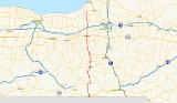
New York State Route 34 (NY 34) is a north–south New York state route located in Central New York
. Its southern terminus is at the Pennsylvania state line in the village of Waverly
, where it connects to Pennsylvania Route 199 and meets NY 17
. Its northern terminus is at NY 104
, outside the village of Hannibal
.
, where PA 199 crosses into New York state, and Tioga County
, on Cayuta Avenue in Waverly
. Little more than half a mile into the state, Cayuta Street (NY 34) comes to a T-intersection with NY 17C
. Route 34 makes a sharp left and, shortly thereafter, a sharp right turn. NY 17C was formerly NY 17, and the afore-mentioned second sharp turn was once Route 34's southern terminus.
NY 34 continues north along the east bank of Cayuta Creek
across the county line to Van Etten
, Chemung County
.
In that village, NY 34 turns east at the eastern terminus of NY 224
. Less than a mile from NY 224, NY 34 exits Chemung County and reenters Tioga County. NY 34 continues east to Spencer
, where it meets up with NY 96
. The routes converge from each end of Tioga Street and continue north together on Main Street. After exiting the village, NY 34 and NY 96 continue northward through the county, entering Tompkins County
five miles (8 km) from Spencer.
, NY 34 and NY 96 merge with Elmira Road near Treman State Park, joining NY 13
northward through Buttermilk Falls State Park
to Ithaca. Formerly, Meadow Street carried both directions of NY 13 and NY 34 (and NY 96) through a large part of Ithaca; however, in the late 1990s southbound traffic was diverted to Fulton Street for a ten-block section. NY 96 diverges to the west at West Buffalo Street in this section. NY 34 diverges from the NY 13 freeway in the northern part of the city. In Ithaca, NY 34 passes the Ithaca Farmers Market, the Sciencenter, and Stewart Park
.
Between NY 13 and Cayuga Heights Road in the Village of Lansing
, NY 34 ascends a hill, offering a view down Cayuga Lake
. The highway is close to the lake shore itself for an approximately two mile stretch prior to the hill. Descending the hill, one is offered a view of the city. Easily seen is the West and East Dormitory Towers of Ithaca College
, located on NY 96B
.
In the town of Lansing
, the highway intersects with NY 34B
, a loop that serves the small communities along the ridge to the west of NY 34. Six miles due north of the NY 34/NY 34B intersection, NY 34 passes into Cayuga County
.
, at the intersection with NY 90
. Five miles south of Auburn
in Fleming
, NY 34B rejoins NY 34, terminating at a T-intersection.
In downtown Auburn, NY 34 is co-signed
with NY 38
from the southern edge of the city north to NY 5
and U.S. Route 20, where NY 38 turns west. Within downtown Auburn, NY 34 passes by the Harriet Tubman Home
and the William Seward House
.
From Auburn, NY 34 continues north to Weedsport
, where the route meets the New York State Thruway
(Interstate 90) at exit 40. Farther north, NY 34 enters Cato
and meets NY 370
in the village center. Six miles to the north, NY 34 changes counties for the final time, entering Oswego County
.
Of the 100 miles (161 km) of NY 34, only four miles of the route exists in Oswego County. NY 34 intersects only six roads in the county, the most notable of which is NY 104, located south of Hannibal
.
s. The portion of what is now NY 34 from Van Etten
to Ithaca
was included in Route 9, which originally began in Horseheads
and went generally northeast across central New York
to Bouckville. North of Ithaca, two sections of modern NY 34—from Cayuga Heights Road north to current NY 34B
in Lansing
and from the north end of NY 34B in Fleming
to Auburn
—became part of Route 11. On March 1, 1921, Route 9 was realigned south of Van Etten to follow modern NY 34 south to Chemung Street in Waverly
. When the first set of posted routes in New York
were assigned in 1924, none of modern NY 34 received a signed designation except for the current overlap between NY 34 and NY 13
south of Ithaca, which became NY 13 at this time.
By 1926, what is now NY 34 from Ithaca north to Cato
was designated as part of NY 40, which continued northwest to Red Creek
mostly by way of modern NY 370
. South of Ithaca, current NY 34 was part of NY 53 from Van Etten to Spencer
. Within Ithaca, NY 13 was routed on Spencer Road and Cayuga Street to Court Street, where NY 13 turned east and followed Court Street and University Avenue out of the city. NY 40, meanwhile, began at NY 15 (now NY 96
) at the intersection of State and Aurora Streets, one block east of NY 13. NY 40 followed Aurora, Falls, and Lake Streets through the city before joining the current alignment of NY 34 at the southeastern edge of Cayuga Lake
.
in the Capital District
. Its former alignment became part of two new routes, namely NY 370 west of Cato and NY 34 south of Cato. Unlike NY 40 before it, NY 34 continued south to Chemung Street (then NY 17
) in Waverly, utilizing the post-1921 alignment of legislative Route 9 between Ithaca and Waverly. NY 34 was extended south to the Pennsylvania state line in the early 1970s following the completion of the Southern Tier Expressway through Waverly.
NY 34 was extended north from Cato to the super two
highway carrying NY 104
around Hannibal
in the early 1970s. Initially, NY 34 veered east on Ira Hill East and North Roads and on Oswego County Route 21 to serve Hannibal Center; however, it was moved onto its current alignment between Cato and Hannibal by 1977. The portion of NY 34 north of Cato was county-maintained until the early 1980s when the state of New York acquired ownership of the highway as part of two highway maintenance swaps with Oswego
and Cayuga
Counties. The section of NY 34 between the Cayuga County line and NY 104 became state-maintained on April 1, 1980, while the segment between NY 370 and the Oswego County line was turned over to the state on April 1, 1981. The county-maintained continuation of NY 34 to NY 3
in Hannibal is designated and signed as County Route 34.
, bypassing downtown Ithaca on the west and north. NY 34 was altered to follow Meadow Street and the freeway between southwestern Ithaca and its original alignment on East Shore Drive north of the city. The portion of NY 34's former alignment on East Shore Drive north of the Ithaca city line became NY 930F, an unsigned reference route. Lastly, in 1996, ten blocks of southbound NY 34 was diverted from Meadow Street to Fulton Street as part of the Octopus elimination project.
Central New York
Central New York is a term used to broadly describe the central region of New York State, roughly including the following counties and cities:...
. Its southern terminus is at the Pennsylvania state line in the village of Waverly
Waverly, Tioga County, New York
----Waverly is the largest village in Tioga County, New York, United States. It is located southeast of Elmira in the Southern Tier region. This village was incorporated as the southwest part of the town of Barton in 1854...
, where it connects to Pennsylvania Route 199 and meets NY 17
New York State Route 17
New York State Route 17 is a state highway that extends for through the Southern Tier and Downstate regions of New York in the United States...
. Its northern terminus is at NY 104
New York State Route 104
New York State Route 104 is a long east–west state highway in Upstate New York, United States. It spans six counties and enters the vicinity of four cities—Niagara Falls, Lockport, Rochester, and Oswego—as it follows a routing largely parallel to that of the southern shoreline of Lake...
, outside the village of Hannibal
Hannibal (village), New York
Hannibal is a village in Oswego County, New York, USA. The population was 542 at the 2000 census. The village is named after Hannibal, the hero of ancient Carthage....
.
Tioga and Chemung Counties
The highway begins at exit 61 of the Southern Tier Expressway, NY 17New York State Route 17
New York State Route 17 is a state highway that extends for through the Southern Tier and Downstate regions of New York in the United States...
, where PA 199 crosses into New York state, and Tioga County
Tioga County, New York
As of the census of 2010, there were 51,125 people residing in the county, with 22,203 housing units, of these 20,350 occupied, 1,853 vacant. The population density was 98 people per square mile...
, on Cayuta Avenue in Waverly
Waverly, Tioga County, New York
----Waverly is the largest village in Tioga County, New York, United States. It is located southeast of Elmira in the Southern Tier region. This village was incorporated as the southwest part of the town of Barton in 1854...
. Little more than half a mile into the state, Cayuta Street (NY 34) comes to a T-intersection with NY 17C
New York State Route 17C
New York State Route 17C is a state highway in the Southern Tier of New York. Its western terminus is at an intersection with NY 34 in Waverly, Tioga County while its eastern terminus is at an intersection with U.S. Route 11 in Binghamton, Broome County...
. Route 34 makes a sharp left and, shortly thereafter, a sharp right turn. NY 17C was formerly NY 17, and the afore-mentioned second sharp turn was once Route 34's southern terminus.
NY 34 continues north along the east bank of Cayuta Creek
Cayuta Creek
Cayuta Creek is a tributary of the Susquehanna River that flows through Schuyler, Chemung and Tioga counties in New York state, and Bradford County, Pennsylvania....
across the county line to Van Etten
Van Etten (village), New York
Van Etten is a village in Chemung County, New York, USA. The population was 581 at the 2000 census. The name comes from the two brothers who founded the village....
, Chemung County
Chemung County, New York
Chemung County is a county located in the U.S. state of New York. It is part of the 'Elmira, New York Metropolitan Statistical Area' which encompasses all of Chemung County. As of the 2010 census, the population was 88,830. Its name is derived from the name of a Delaware Indian village . Its...
.
In that village, NY 34 turns east at the eastern terminus of NY 224
New York State Route 224
New York State Route 224 is a state highway in the Southern Tier of New York, United States. The route is signed as north–south; however, in actuality the highway follows more of an east–west routing across southeastern Schuyler County and northeastern Chemung County...
. Less than a mile from NY 224, NY 34 exits Chemung County and reenters Tioga County. NY 34 continues east to Spencer
Spencer (village), New York
Spencer is a village located in the Town of Spencer in Tioga County, New York, USA. The population was 731 at the 2000 census. It is part of the Binghamton Metropolitan Statistical Area...
, where it meets up with NY 96
New York State Route 96
New York State Route 96 is a northwest–southeast state highway in the Finger Lakes region of New York in the United States. The southern terminus of the route is at an interchange with NY 17 in the Southern Tier village of Owego, Tioga County. Its northern terminus is at a junction with...
. The routes converge from each end of Tioga Street and continue north together on Main Street. After exiting the village, NY 34 and NY 96 continue northward through the county, entering Tompkins County
Tompkins County, New York
Tompkins County is a county located in the U.S. state of New York, and comprises the whole of the Ithaca metropolitan area. As of the 2010 census, the population was 101,564. The county seat is Ithaca, and the county is home to Cornell University, Ithaca College and Tompkins Cortland Community...
five miles (8 km) from Spencer.
Tompkins County
A few miles south of IthacaIthaca, New York
The city of Ithaca, is a city in upstate New York and the county seat of Tompkins County, as well as the largest community in the Ithaca-Tompkins County metropolitan area...
, NY 34 and NY 96 merge with Elmira Road near Treman State Park, joining NY 13
New York State Route 13
New York State Route 13 is a state highway that runs mainly north–south for between NY 14 in Horseheads and NY 3 west of Pulaski in Central New York in the United States. In between, NY 13 intersects with Interstate 81 in Cortland and Pulaski and meets the New York...
northward through Buttermilk Falls State Park
Buttermilk Falls State Park
Buttermilk Falls State Park is located southwest of Ithaca, New York, USA. Like Robert H. Treman State Park, the initial grant of land for the park came from Robert and Laura Treman, in 1924....
to Ithaca. Formerly, Meadow Street carried both directions of NY 13 and NY 34 (and NY 96) through a large part of Ithaca; however, in the late 1990s southbound traffic was diverted to Fulton Street for a ten-block section. NY 96 diverges to the west at West Buffalo Street in this section. NY 34 diverges from the NY 13 freeway in the northern part of the city. In Ithaca, NY 34 passes the Ithaca Farmers Market, the Sciencenter, and Stewart Park
Stewart Park
Stewart Park is in Ithaca, New York. Ithaca is located on the southern tip of Cayuga Lake, the largest Finger Lake, and Stewart sits directly on that tip. The park is a popular place for barbecues, frisbee, tennis, baseball, and softball, as well as fishing and swimming on the lake. The park has a...
.
Between NY 13 and Cayuga Heights Road in the Village of Lansing
Lansing (village), New York
Lansing is a village in Tompkins County, New York, United States. The population was 3,417 at the 2000 census.The Village of Lansing is in the Town of Lansing and is north of Ithaca....
, NY 34 ascends a hill, offering a view down Cayuga Lake
Cayuga Lake
Cayuga Lake is the longest of central New York's glacial Finger Lakes, and is the second largest in surface area and second largest in volume. It is just under 40 miles long. Its average width is 1.7 miles , and it is at its widest point near Aurora...
. The highway is close to the lake shore itself for an approximately two mile stretch prior to the hill. Descending the hill, one is offered a view of the city. Easily seen is the West and East Dormitory Towers of Ithaca College
Ithaca College
Ithaca College is a private college located on the South Hill of Ithaca, New York. The school was founded by William Egbert in 1892 as a conservatory of music. The college has a strong liberal arts core, but also offers several pre-professional programs and some graduate programs. The college is...
, located on NY 96B
New York State Route 96B
New York State Route 96B is a north–south state highway in the Southern Tier of New York, United States. It connects NY 96 in the village of Candor in Tioga County to NY 13, NY 34, and NY 96 in the city of Ithaca in Tompkins County...
.
In the town of Lansing
Lansing (town), New York
Lansing is a town in Tompkins County, New York, United States. The population was 10,521 at the 2000 census. The town is named after John Lansing. Settlers from Lansing were early residents of the then-township of Lansing, Michigan and named it after their hometown; it would later become a city...
, the highway intersects with NY 34B
New York State Route 34B
New York State Route 34B is a north–south state highway located within Tompkins and Cayuga Counties in Central New York. Its northern terminus is located at a junction with NY 34 by the hamlet of Fleming within the town of the same name in Cayuga County...
, a loop that serves the small communities along the ridge to the west of NY 34. Six miles due north of the NY 34/NY 34B intersection, NY 34 passes into Cayuga County
Cayuga County, New York
Cayuga County is a county located in the U.S. state of New York. It was named for one of the tribes of Indians in the Iroquois Confederation. Its county seat is Auburn.- History :...
.
Cayuga and Oswego Counties
Like NY 34B to the west, NY 34 serves a handful of small communities in southern and central Cayuga county, including GenoaGenoa, New York
Genoa is a town in Cayuga County, New York, United States. The population was 1,935 at the 2010 census.The Town of Genoa is located in the southwest corner of the county and is north of Ithaca, New York...
, at the intersection with NY 90
New York State Route 90
New York State Route 90 is a north–south state highway in the Finger Lakes region of New York, United States. All but five of the route's are located in Cayuga County, with the remaining situated in Cortland County. The southern terminus of the route is at an intersection with U.S....
. Five miles south of Auburn
Auburn, New York
Auburn is a city in Cayuga County, New York, United States of America. As of the 2010 census, the city had a population of 27,687...
in Fleming
Fleming, New York
Fleming is a town in Cayuga County, New York, United States. The population was 2,636 at the 2010 census. The name is that of General George Fleming, an early settler.The Town of Fleming is at the north end of Owasco Lake, south of Auburn, New York....
, NY 34B rejoins NY 34, terminating at a T-intersection.
In downtown Auburn, NY 34 is co-signed
Concurrency (road)
A concurrency, overlap, or coincidence in a road network is an instance of one physical road bearing two or more different highway, motorway, or other route numbers...
with NY 38
New York State Route 38
New York State Route 38 is a north–south state highway in the Finger Lakes region of New York in the United States. Its southern terminus is at an intersection with NY 96 in the town of Owego in Tioga County. The northern terminus is at a junction with NY 104A in the town of...
from the southern edge of the city north to NY 5
New York State Route 5
New York State Route 5 is a state highway that extends for across the state of New York in the United States. It begins at the Pennsylvania state line in the Chautauqua County town of Ripley and passes through Buffalo, Syracuse, Utica, Schenectady, and several other smaller cities and...
and U.S. Route 20, where NY 38 turns west. Within downtown Auburn, NY 34 passes by the Harriet Tubman Home
Harriet Tubman
Harriet Tubman Harriet Tubman Harriet Tubman (born Araminta Harriet Ross; (1820 – 1913) was an African-American abolitionist, humanitarian, and Union spy during the American Civil War. After escaping from slavery, into which she was born, she made thirteen missions to rescue more than 70 slaves...
and the William Seward House
William H. Seward
William Henry Seward, Sr. was the 12th Governor of New York, United States Senator and the United States Secretary of State under Abraham Lincoln and Andrew Johnson...
.
From Auburn, NY 34 continues north to Weedsport
Weedsport, New York
Weedsport is a village in Cayuga County, New York, USA. The population was 2,017 at the 2000 census. The name is from Elihu and Edward Weed, merchants who helped found the village....
, where the route meets the New York State Thruway
New York State Thruway
The New York State Thruway is a system of limited-access highways located within the state of New York in the United States. The system, known officially as the Governor Thomas E. Dewey Thruway for former New York Governor Thomas E. Dewey, is operated by the New York State Thruway Authority and...
(Interstate 90) at exit 40. Farther north, NY 34 enters Cato
Cato (village), New York
Cato is a village in Cayuga County, New York, United States. The population was 601 at the 2000 census. The name was assigned by the surveyors of the Military Tract, and is one of many towns and villages bearing classical place names....
and meets NY 370
New York State Route 370
New York State Route 370 is an east–west state highway in central New York in the United States. It extends for from an intersection with NY 104 and NY 104A south of the Wayne County village of Red Creek to a junction with U.S. Route 11 in the Onondaga County city of Syracuse...
in the village center. Six miles to the north, NY 34 changes counties for the final time, entering Oswego County
Oswego County, New York
Oswego County is a county located in the U.S. state of New York. As of the 2010 Census, the estimated population was 122,109. The City of Oswego and the Village of Pulaski serve as the dual county seats in a two shire system of government...
.
Of the 100 miles (161 km) of NY 34, only four miles of the route exists in Oswego County. NY 34 intersects only six roads in the county, the most notable of which is NY 104, located south of Hannibal
Hannibal (village), New York
Hannibal is a village in Oswego County, New York, USA. The population was 542 at the 2000 census. The village is named after Hannibal, the hero of ancient Carthage....
.
Origins
In 1908, the New York State Legislature created a statewide system of unsigned legislative routeLegislative route
In United States, a legislative route or legislative highway is a highway defined by laws passed in a state legislature. The numbering of such highways may or may not correspond to the numbers familiar to the public as part of the state, U.S. highway, and Interstate highway systems...
s. The portion of what is now NY 34 from Van Etten
Van Etten (village), New York
Van Etten is a village in Chemung County, New York, USA. The population was 581 at the 2000 census. The name comes from the two brothers who founded the village....
to Ithaca
Ithaca, New York
The city of Ithaca, is a city in upstate New York and the county seat of Tompkins County, as well as the largest community in the Ithaca-Tompkins County metropolitan area...
was included in Route 9, which originally began in Horseheads
Horseheads (village), New York
Horseheads is a village in Chemung County, New York, USA. The population was 6,461 at the 2010 census. The name is derived from the number of bleached skulls of pack horses left behind by the Sullivan Expedition....
and went generally northeast across central New York
Central New York
Central New York is a term used to broadly describe the central region of New York State, roughly including the following counties and cities:...
to Bouckville. North of Ithaca, two sections of modern NY 34—from Cayuga Heights Road north to current NY 34B
New York State Route 34B
New York State Route 34B is a north–south state highway located within Tompkins and Cayuga Counties in Central New York. Its northern terminus is located at a junction with NY 34 by the hamlet of Fleming within the town of the same name in Cayuga County...
in Lansing
Lansing (town), New York
Lansing is a town in Tompkins County, New York, United States. The population was 10,521 at the 2000 census. The town is named after John Lansing. Settlers from Lansing were early residents of the then-township of Lansing, Michigan and named it after their hometown; it would later become a city...
and from the north end of NY 34B in Fleming
Fleming, New York
Fleming is a town in Cayuga County, New York, United States. The population was 2,636 at the 2010 census. The name is that of General George Fleming, an early settler.The Town of Fleming is at the north end of Owasco Lake, south of Auburn, New York....
to Auburn
Auburn, New York
Auburn is a city in Cayuga County, New York, United States of America. As of the 2010 census, the city had a population of 27,687...
—became part of Route 11. On March 1, 1921, Route 9 was realigned south of Van Etten to follow modern NY 34 south to Chemung Street in Waverly
Waverly, Tioga County, New York
----Waverly is the largest village in Tioga County, New York, United States. It is located southeast of Elmira in the Southern Tier region. This village was incorporated as the southwest part of the town of Barton in 1854...
. When the first set of posted routes in New York
New York
New York is a state in the Northeastern region of the United States. It is the nation's third most populous state. New York is bordered by New Jersey and Pennsylvania to the south, and by Connecticut, Massachusetts and Vermont to the east...
were assigned in 1924, none of modern NY 34 received a signed designation except for the current overlap between NY 34 and NY 13
New York State Route 13
New York State Route 13 is a state highway that runs mainly north–south for between NY 14 in Horseheads and NY 3 west of Pulaski in Central New York in the United States. In between, NY 13 intersects with Interstate 81 in Cortland and Pulaski and meets the New York...
south of Ithaca, which became NY 13 at this time.
By 1926, what is now NY 34 from Ithaca north to Cato
Cato (village), New York
Cato is a village in Cayuga County, New York, United States. The population was 601 at the 2000 census. The name was assigned by the surveyors of the Military Tract, and is one of many towns and villages bearing classical place names....
was designated as part of NY 40, which continued northwest to Red Creek
Red Creek, New York
Red Creek is a village in Wayne County, New York, United States. The population was 521 at the 2000 census.The Village of Red Creek is in the eastern part of the Town of Wolcott. The village is west of Syracuse, New York.- History :...
mostly by way of modern NY 370
New York State Route 370
New York State Route 370 is an east–west state highway in central New York in the United States. It extends for from an intersection with NY 104 and NY 104A south of the Wayne County village of Red Creek to a junction with U.S. Route 11 in the Onondaga County city of Syracuse...
. South of Ithaca, current NY 34 was part of NY 53 from Van Etten to Spencer
Spencer (village), New York
Spencer is a village located in the Town of Spencer in Tioga County, New York, USA. The population was 731 at the 2000 census. It is part of the Binghamton Metropolitan Statistical Area...
. Within Ithaca, NY 13 was routed on Spencer Road and Cayuga Street to Court Street, where NY 13 turned east and followed Court Street and University Avenue out of the city. NY 40, meanwhile, began at NY 15 (now NY 96
New York State Route 96
New York State Route 96 is a northwest–southeast state highway in the Finger Lakes region of New York in the United States. The southern terminus of the route is at an interchange with NY 17 in the Southern Tier village of Owego, Tioga County. Its northern terminus is at a junction with...
) at the intersection of State and Aurora Streets, one block east of NY 13. NY 40 followed Aurora, Falls, and Lake Streets through the city before joining the current alignment of NY 34 at the southeastern edge of Cayuga Lake
Cayuga Lake
Cayuga Lake is the longest of central New York's glacial Finger Lakes, and is the second largest in surface area and second largest in volume. It is just under 40 miles long. Its average width is 1.7 miles , and it is at its widest point near Aurora...
.
Designation and extensions
In the 1930 renumbering of state highways in New York, NY 40 was reassigned to another highwayNew York State Route 40
New York State Route 40 is a north–south state highway in eastern New York, United States. It is long and runs from NY 7 in the city of Troy north to NY 22 in the town of Granville. NY 40 also passes through the villages of Schaghticoke and Argyle and enters the vicinity of...
in the Capital District
Capital District
New York's Capital District, also known as the Capital Region, is a region in upstate New York that generally refers to the four counties surrounding Albany, the capital of the state: Albany County, Schenectady County, Rensselaer County, and Saratoga County...
. Its former alignment became part of two new routes, namely NY 370 west of Cato and NY 34 south of Cato. Unlike NY 40 before it, NY 34 continued south to Chemung Street (then NY 17
New York State Route 17
New York State Route 17 is a state highway that extends for through the Southern Tier and Downstate regions of New York in the United States...
) in Waverly, utilizing the post-1921 alignment of legislative Route 9 between Ithaca and Waverly. NY 34 was extended south to the Pennsylvania state line in the early 1970s following the completion of the Southern Tier Expressway through Waverly.
NY 34 was extended north from Cato to the super two
Super two
A super two, super two-lane highway or wide two lane is a two-lane surface road built to high standards, typically including partial control of access, occasional passing lanes and hard shoulders...
highway carrying NY 104
New York State Route 104
New York State Route 104 is a long east–west state highway in Upstate New York, United States. It spans six counties and enters the vicinity of four cities—Niagara Falls, Lockport, Rochester, and Oswego—as it follows a routing largely parallel to that of the southern shoreline of Lake...
around Hannibal
Hannibal (village), New York
Hannibal is a village in Oswego County, New York, USA. The population was 542 at the 2000 census. The village is named after Hannibal, the hero of ancient Carthage....
in the early 1970s. Initially, NY 34 veered east on Ira Hill East and North Roads and on Oswego County Route 21 to serve Hannibal Center; however, it was moved onto its current alignment between Cato and Hannibal by 1977. The portion of NY 34 north of Cato was county-maintained until the early 1980s when the state of New York acquired ownership of the highway as part of two highway maintenance swaps with Oswego
Oswego County, New York
Oswego County is a county located in the U.S. state of New York. As of the 2010 Census, the estimated population was 122,109. The City of Oswego and the Village of Pulaski serve as the dual county seats in a two shire system of government...
and Cayuga
Cayuga County, New York
Cayuga County is a county located in the U.S. state of New York. It was named for one of the tribes of Indians in the Iroquois Confederation. Its county seat is Auburn.- History :...
Counties. The section of NY 34 between the Cayuga County line and NY 104 became state-maintained on April 1, 1980, while the segment between NY 370 and the Oswego County line was turned over to the state on April 1, 1981. The county-maintained continuation of NY 34 to NY 3
New York State Route 3
New York State Route 3 is a major east–west state highway in New York, United States, that connects central New York to the North Country region near the Canadian border via Adirondack Park. The route extends for between its western terminus at an intersection with NY 104A in the Cayuga...
in Hannibal is designated and signed as County Route 34.
Ithaca area
NY 34 has been realigned through Ithaca at least three times since the 1930s. By 1948, NY 34 was shifted westward to follow Albany, Court, and Cayuga Streets through downtown. In the early 1960s, a new expressway was built along the eastern shore of Cayuga LakeCayuga Lake
Cayuga Lake is the longest of central New York's glacial Finger Lakes, and is the second largest in surface area and second largest in volume. It is just under 40 miles long. Its average width is 1.7 miles , and it is at its widest point near Aurora...
, bypassing downtown Ithaca on the west and north. NY 34 was altered to follow Meadow Street and the freeway between southwestern Ithaca and its original alignment on East Shore Drive north of the city. The portion of NY 34's former alignment on East Shore Drive north of the Ithaca city line became NY 930F, an unsigned reference route. Lastly, in 1996, ten blocks of southbound NY 34 was diverted from Meadow Street to Fulton Street as part of the Octopus elimination project.
Suffixed routes
NY 34 has had two suffixed routes; one has since been removed.- NY 34A was an alternate route of NY 34 between Ithaca and LansingLansing (town), New YorkLansing is a town in Tompkins County, New York, United States. The population was 10,521 at the 2000 census. The town is named after John Lansing. Settlers from Lansing were early residents of the then-township of Lansing, Michigan and named it after their hometown; it would later become a city...
. It split from NY 34 at the intersection of Court and Cayuga Streets, where NY 34 turned north to follow Cayuga through downtown. NY 34A was routed along Court Street, Linn Street, University Avenue, and Cayuga Heights Road through Ithaca to Lansing, where it rejoined its parent north of the city. The route was assigned ca. 1932 and eliminated in the mid-1960s. - NY 34BNew York State Route 34BNew York State Route 34B is a north–south state highway located within Tompkins and Cayuga Counties in Central New York. Its northern terminus is located at a junction with NY 34 by the hamlet of Fleming within the town of the same name in Cayuga County...
(34.03 miles or 54.77 km) is an alternate route of NY 34 from NY 38New York State Route 38New York State Route 38 is a north–south state highway in the Finger Lakes region of New York in the United States. Its southern terminus is at an intersection with NY 96 in the town of Owego in Tioga County. The northern terminus is at a junction with NY 104A in the town of...
south of Groton, Tompkins CountyTompkins County, New YorkTompkins County is a county located in the U.S. state of New York, and comprises the whole of the Ithaca metropolitan area. As of the 2010 census, the population was 101,564. The county seat is Ithaca, and the county is home to Cornell University, Ithaca College and Tompkins Cortland Community...
to NY 34 south of AuburnAuburn, New YorkAuburn is a city in Cayuga County, New York, United States of America. As of the 2010 census, the city had a population of 27,687...
, Cayuga CountyCayuga County, New YorkCayuga County is a county located in the U.S. state of New York. It was named for one of the tribes of Indians in the Iroquois Confederation. Its county seat is Auburn.- History :...
. From NY 38 to NY 34 in LansingLansing (town), New YorkLansing is a town in Tompkins County, New York, United States. The population was 10,521 at the 2000 census. The town is named after John Lansing. Settlers from Lansing were early residents of the then-township of Lansing, Michigan and named it after their hometown; it would later become a city...
, NY 34B is an east–west route; past Lansing, NY 34B follows a north–south routing that largely parallels NY 34. It was assigned as part of the 1930 renumbering of state highways in New York.