
Calakmul
Encyclopedia
Calakmul is a Maya
archaeological site in the Mexican state of Campeche
, deep in the jungles of the greater Petén Basin
region. It is 35 kilometres (21.7 mi) from the Guatemala
n border. Calakmul was one of the largest and most powerful ancient cities
ever uncovered in the Maya
lowlands. Calakmul is a modern name, in ancient times the city core was known as Ox Te' Tuun.
Calakmul was a major Maya power within the northern Peten
region of the Yucatan
of southern Mexico. Calakmul administered a large domain marked by the extensive distribution of their emblem glyph of the snake head sign, to be read "Kaan". Calakmul was the seat of what has been dubbed the Kingdom of the Snake or Snake Kingdom. This Snake Kingdom reigned during most of the Classic period
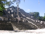
. Calakmul itself is estimated to have had a population of 50,000 people and had governance, at times, over places as far away as 150 kilometers. There are 6,750 ancient structures identified at Calakmul the largest of which is the great pyramid at the site. Structure 2 is over 45 metres (147.6 ft) high, making it one of the tallest of the Maya pyramids
. Four tombs have been located within the pyramid. Like many temples or pyramids within Mesoamerica
the pyramid at Calakmul increased in size by building upon the existing temple to reach its current size. The size of the central monumental architecture
is approximately 2 square kilometre (0.77220431718507 sq mi) and the whole of the site, mostly covered with dense residential structures, is about 20 square kilometres (7.7 sq mi).
Throughout the Classic Period, Calakmul maintained an intense rivalry with the major city of Tikal
to the south, and the political manoeuvrings of these two cities have been likened to a struggle between two Maya superpowers.
Rediscovered from the air by biologist Cyrus L. Lundell of the Mexican Exploitation Chicle Company on December 29, 1931, the find was reported to Sylvanus G. Morley
of the Carnegie Institute
at Chichen Itza
in March 1932. According to Lundell, who named the site, "In Maya, 'ca' means 'two', 'lak' means 'adjacent', and 'mul' signifies any artificial mound or pyramid, so 'Calakmul' is the 'City of the Two Adjacent Pyramids'."
state in southeastern Mexico, about 35 kilometres (21.7 mi) north of the border with Guatemala
and 38 kilometres (23.6 mi) north of the ruins of El Mirador
. The ruins of El Tintal
are 68 kilometres (42.3 mi) to the southwest of Calakmul and were linked to both El Mirador and Calakmul itself by causeway. Calakmul was about 20 kilometres (12.4 mi) south of the contemporary city of Oxpemul and approximately 25 kilometres (15.5 mi) southwest of La Muñeca. The city is located on a rise about 35 metres (114.8 ft) above a large seasonal swamp
lying to the west, known as the El Laberinto bajo (a Spanish
word used in the region to denote a low-lying area of seasonal marshland). This swamp measures approximately 34 by and was an important source of water during the rain season. The bajo was linked to a sophisticated water-control system including both natural and artificial features such as gullies and canals that encircled a 22 square kilometres (8.5 sq mi) area around the site core, an area considered as Inner Calakmul. The location of Calakmul at the edge of a bajo provided two additional advantages: the fertile soils along the edge of the swamp and access to abundant flint
nodules
. The city is situated on a promontory formed by a natural 35 metres (114.8 ft) high limestone
dome rising above the surrounding lowlands. This dome was artificially levelled by the Maya. During the Preclassic
and Classic periods settlement was concentrated along the edge of the El Laberinto bajo, during the Classic period structures were also built on high ground and small islands in the swamp where flint was worked.
At the beginning of the 21st century the area around Calakmul remained covered by dense forest. During the 1st millennium AD the area received moderate and regular rainfall, although there is less surface water available than further south in Guatemala. Calakumul is now located within the 1800000 acres (7,284.3 km²) Calakmul Biosphere Reserve
.
The Late Classic population density of Calakmul has been calculated at 1000/km² (2564 per square mile) in the site core and 420/km² (1076 per square mile) in the periphery (an area of 122 square kilometres (47.1 sq mi). Calakmul was a true urban city and not just an elite centre surrounded by commoner residences. The site core of Calakmul was known in ancient times as Ox Te' Tuun ("Place of Three Stones") which may have been because of the triadic pyramid
Structure 2.
The Calakmul kingdom included 20 secondary centres, among which were large cities such as La Muñeca, Naachtun
, Sasilha, Oxpemul and Uxul. The total population of these secondary centres has been estimated at 200,000. The kingdom also included a large number of tertiary and quaternary sites, mostly fairly small and consisting of a number of groups arranged around courtyards, although there are also larger rural sites situated on ridges along the edges of the bajos that include temples, palaces and stelae. The total rural population of the kingdom is calculated at 1.5 million people. The entire population of the Calakmul kingdom, including the city itself and the rural population in the 13000 square kilometres (5,019.3 sq mi) area of the regional state, is calculated at 1.75 million people in the Late Classic period.
The Emblem Glyph of Calakmul has a greater distribution than the Emblem Glyph of any other Maya city. The Glyph is also found in more hieroglyphic texts than any other Emblem Glyph, including that of Tikal. Calakmul administered a large domain marked by the extensive distribution of their emblem glyph of the snake head sign, to be read "Kaan". Calakmul was the seat of what has been dubbed the Snake Kingdom. At times the city had governance over places as far away as 150 kilometers.
 The kings of Calakmul were known as k'uhul kan ajaw
ob ("Divine Lords of the Snake Kingdom"). This list is not continuous, as the archaeological record is incomplete. All dates AD.
. The causeway network that linked Calakmul with the cities of El Mirador, Nakbe and El Tintal suggest strong political links between the four cities that may have begun in the Preclassic, when both Calakmul and El Mirador where important cities, and continued into the Classic period when Calakmul itself was the most powerful city in the region. Calakmul was one of the largest and most powerful ancient cities
ever uncovered in the Maya
lowlands.
in the Middle Preclassic. However Calakmul was a rival city with equivalent resources that challenged the supremacy of Tikal and engaged in a strategy of surrounding it with its own network of allies. From the second half of the 6th century AD through to the late 7th century Calakmul gained the upper hand although it failed to extinguish Tikal's power completely and Tikal was able to turn the tables on its great rival in a decisive battle that took place in AD 695. Half a century later Tikal was able to gain major victories over Calakmul's most important allies. Eventually both cities succumbed to the spreading Classic Maya collapse
.
The great rivalry between these two cities may have been based on more than competition for resources. Their dynastic histories reveal different origins and the intense competition between the two powers may have had an ideological grounding. Calakmul's dynasty seems ultimately derived from the great Preclassic city of El Mirador while the dynasty of Tikal was profoundly affected by the intervention of the distant central Mexican metropolis of Teotihuacan
. With few exceptions, Tikal's monuments and those of its allies place great emphasis upon single male rulers while the monuments of Calakmul and its allies gave greater prominence to the female line and often the joint rule of king and queen.
and relocating itself to Calakmul in the Classic period after the collapse of these cities.
from stelae
found in Structure 2 record the probable enthronement of a king of Calakmul in AD 411 and also records a non-royal site ruler in 514. After this there is a gap in the hieroglyphic records that lasts over a century, although the Kaan dynasty experienced a major expansion of its power at this time. The lack of inscriptions recording the events of this period may be either due to the fact that the Kaan dynasty was located elsewhere during this time or perhaps that the monuments were later destroyed.
The earliest legible texts referring to the kings of the Kaan dynasty come from excavations of the large city of Dzibanche in Quintana Roo
, far north of Calakmul. A hieroglyphic stairway depicts bound captives, their names and the dates they were captured together with the name of king Yuknoom Che'en I, although the exact context of the king's name is unclear - the captives may have been his vassals captured by an enemy or they may have been rulers captured by the king of Calakmul. The dates are uncertain but two of them may fall within the 5th century AD. The nearby Quintana Roo site of El Resbalón has a jumbled hieroglyphic text, including a date in 529, that indicates that the city was within the control of the Kaan dynasty.
By the middle of the 6th century AD Calakmul was assembling a far-reaching political alliance, activity that brought the city into conflict with the great city of Tikal. The influence of Calakmul extended deep into the Petén
; king Tuun K'ab' Hix of Calakmul oversaw the enthronement of Aj Wosal to the rulership of Naranjo
in 546. Another vassal of Tuun K'ab' Hix was taken captive by Yaxchilán
on the banks of the Usumacinta River
in 537.
In 561, the king now known as Sky Witness
installed a ruler at the site of Los Alacranes. Sky Witness played a major part in the political events of the Maya region, he became the overlord of the city of Caracol
, to the south of Naranjo, which had previously been a vassal of Tikal. In 562, according to a damaged text at Caracol, Sky Witness defeated Tikal itself and sacrificed its king Wak Chan K'awiil, thus ending his branch of the royal dynasty at Tikal. This catastrophic defeat began a 130 year hiatus for Tikal, reflecting an extended period of dominance by Calakmul. This event is used as a marker to divide the Early Classic from the Late Classic. Sky Witness is also mentioned at Okop
, a site much further north in Quintana Roo. The last reference to Sky Witness occurs at Caracol and is dated to AD 572. The text is damaged but probably records the death of this powerful king.
was quickly succeeded by First Axewielder, who is mentioned in a text from Dzibanche celebrating the K'atun-ending of 573. First Axewielder ruled for about six years. In 579 Uneh Chan became king of Calakmul. Uneh Chan engaged in an aggressive campaign in the western Maya region and attacked Palenque
on 23 April 599 with his ally Lakam Chak, lord of the small city of Santa Elena 70 kilometres (43.5 mi) east of Palenque, defeating Palenque's queen Lady Yohl Ik'nal and sacking the city. The defeat is recorded on a series of hieroglyphic steps at Palenque itself and the event initiated a long-lasting grudge against Calakmul. Lady Yohl Ik'nal survived the battle and ruled for several more years, although she perhaps paid tribute to Calakmul.
Uneh Chan maintained his alliances with cities in the east and he is depicted on Caracol Stela 4 supervising an event involving king Yajaw Te' K'inich of that city that occurred before 583. Calakmul again sacked Palenque on 7 April 611 under the personal direction of Uneh Chan. Palenque was now ruled by king Ajen Yohl Mat who had gained some sort of independence from Calakmul, provoking the new invasion. The immediate aftermath of this second victory over Palenque involved the deaths of the two most important nobles at the city, Ajen Yohl Mat himself and Janab Pakal, a high ranking member of the royal family and possibly co-ruler. Janab Pakal died in March 612 and Ajen Yohl Mat a few months later. Their deaths so soon after the sacking of the city suggests that their demise was directly linked to Calakmul's triumph. Palenque suffered a lengthy decline in its fortunes after this date before it was able to recover from its disastrous war
with Calakmul. The wars against Palenque may have been undertaken by Uneh Chan in order to seize control of wealthy trade routes that passed through the western Maya region.
In 629 Tikal had founded Dos Pilas
in the Petexbatún
region, some 110 kilometres (68.4 mi) to its southwest, as a military outpost in order to control trade along the course of the Pasión River
. B'alaj Chan K'awiil was installed on the throne of the new outpost at the age of four, in 635, and for many years served as a loyal vassal fighting for his brother, the king of Tikal. In AD 648 Calakmul attacked Dos Pilas and gained an overwhelming victory that included the death of a Tikal lord. B'alaj Chan K'awiil was captured by Yuknoom Che'en II but, instead of being sacrificed, he was re-instated on his throne as a vassal of the Calakmul king, and went on to attack Tikal in 657, forcing Nuun Ujol Chaak, the then king of Tikal, to temporarily abandon the city. The first two rulers of Dos Pilas continued to use the Mutal emblem glyph of Tikal, and they probably felt that they had a legitimate claim to the throne of Tikal itself. For some reason, B'alaj Chan K'awiil was not installed as the new ruler of Tikal; instead he stayed at Dos Pilas. Tikal counterattacked against Dos Pilas in 672, driving B'alaj Chan K'awiil into an exile that lasted five years. Calakmul tried to encircle Tikal within an area dominated by its allies, such as El Peru, Dos Pilas and Caracol. In 677 Calakmul counterattacked against Dos Pilas, driving Tikal out and reinstalled B'alaj Chan K'awiil on his throne. In 679 Dos Pilas, probably aided by Calakmul, gained an important victory over Tikal, with a hieroglyphic description of the battle describing pools of blood and piles of heads.
Troubles continued in the east, with renewed conflict between Naranjo and Caracol. Naranjo completely defeated Caracol in 680 but Naranjo's dynasty disappeared within two years and a daughter of B'alaj Chan K'awiil founded a new dynasty there in 682, indicating that Calakmul had probably intervened decisively to place a loyal vassal on the throne. The patronage of Yuknoom Che'en II as overlord is recorded at a range of important cities, including El Peru where he oversaw the installation of K'inich B'alam as king and strengthened the tie with the marriage of a Calakmul princess to that king. The power of Calakmul extended as far as the north shore of Lake Petén Itzá
, where Motul de San José
is recorded as its vassal in the 7th century, although it was traditionally aligned with Tikal. Yuknoom Che'en II commanded the loyalty of three generations of kings at Cancuen
, 245 kilometres (152.2 mi) to the south, and supervised the enthronement of at least two of them, in 656 and 677. King Yuknoom Che'en II was involved, directly or indirectly, in the crowning of a king at Moral to the west in Tabasco
and one of Yuknoom's nobles supervised a ritual at Piedras Negras on the Guatemalan bank of the Usumacinta River
. Yuknoom Che'en II died in his eighties, probably at the beginning of 686. When he died, Calakmul was the most powerful city in the central Maya lowlands.
Yuknoom Yich'aak K'ak' succeeded Yuknoom Che'en II, his crowning on 3 April 686 was recorded on monuments at Dos Pilas and El Peru. He was born in 649 and was likely to have been the son of his predecessor. He already held high office before he was named king and may have been responsible for the major successes of the latter part of Yuknoom Che'en II's reign. He retained the loyalty of K'inich B'alam of El Peru and B'alaj Chan K'awiil of Dos Pilas and gained that of K'ak' Tiliw Chan Chaak in 693, when he was installed on the throne of Naranjo at the age of five. However, the texts on sculpted monuments do not reveal the full complexity of diplomatic activity, as revealed by a painted ceramic vase from Tikal, which depicts an ambassador of Calakmul's king kneeling before the enthroned king of Tikal and delivering tribute. Just four years later, in August 695, the two states were once again at war. Yuknoom Yich'aak K'ak' led his warriors against Jasaw Chan K'awiil I in a catastrophic battle that saw the defeat of Calakmul and the capture of the image of a Calakmul deity named Yajaw Maan. It is unknown what happened to Yuknoom Yich'aak K'ak'; a stucco sculpture from Tikal shows a captive and the king is mentioned in the accompanying caption but it is not certain if the captive and the king are the same person. This event marked the end of Calakmul's apogee, with diplomatic activity dropping away and fewer cities recognising Calakmul's king as overlord. No stelae remain standing in the site core recording Yuknoom Yich'aal K'ak, although there are some in the Northeast Group and 2 broken stelae were buried in Structure 2.
The next known king used a number of name variants, and is referred to by different name segments within and outside of Calakmul. A partial reading of his name is Yuknoom Took' K'awiil. He erected seven stelae to celebrate a calendrical event in 702 and is named at Dos Pilas in that year, presumably demonstrating that Dos Pilas was still a vassal of Calakmul. El Peru also continued as a vassal and Yuknoom Took' K'awiil installed a new king there at an unknown date. Naranjo also remained loyal. Yuknoom Took' K'awiil commissioned seven more stelae to mark the k'atun-ending of 731. A new defeat at the hands of Tikal is evidenced by a sculpted altar at that city, probably dating to sometime between 733 and 736, depicting a bound lord from Calakmul and possibly names Yuknoom Took' K'awiil.
After this the historical record of Calakmul becomes very vague, due both to the poor state of the heavily eroded monuments at the city itself and also its reduced political presence on the wider Maya stage. Wamaw K'awiil is named at Quiriguá
on the southern periphery of Mesoamerica. Quiriguá traditionally had been a vassal of its southern neighbour Copán
, and in 724 Uaxaclajuun Ub'aah K'awiil
, king of Copán, installed K'ak' Tiliw Chan Yopaat upon Quiriguá's throne as his vassal. By 734 K'ak' Tiliw Chan Yopaat had shown that he was no longer an obedient subordinate of Copán when he started to refer to himself as k'ul ahaw
, holy lord, instead of using the lesser term ahaw, subordinate lord; at the same time he began to use his own Quiriguá emblem glyph. This local act of rebellion appears to have been part of the larger political struggle between Tikal and Calakmul. In 736, only two years later, K'ak' Tiliw Chan Yopaat received a visit from Wamaw K'awiil of Calakmul, while Copán was one of Tikal's oldest allies. The timing of this visit by the king of Calakmul is highly significant, falling between the accession of K'ak' Tiliw Chan Yopaat to the throne of Quiriguá as a vassal of Copán and the outright rebellion that was to follow. This strongly suggests that Calakmul sponsored Quiriguá's rebellion in order to weaken Tikal and to gain access to the rich trade route of the Motagua Valley
. It is likely that contact with Calakmul had been initiated soon after K'ak' Tiliw Chan Yopaat acceded to the throne. In 738 K'ak' Tiliw Chan Yopaat captured the powerful but elderly king of Copán, Uaxaclajuun Ub'aah K'awiil. An inscription at Quiriguá, although difficult to interpret, suggests that the capture took place on 27 April 738, when Quiriguá seized and burned the wooden images of Copán's patron deities
. The captured lord was taken back to Quiriguá and on 3 May 738 he was decapitated in a public ritual.
In the Late Classic, alliance with Calakmul was frequently associated with the promise of military support. The fact that Copán, a much more powerful city than Quiriguá, failed to retaliate against its former vassal implies that it feared the military intervention of Calakmul. Calakmul itself was far enough away from Quiriguá that K'ak' Tiliw Chan Yopaat was not afraid of falling directly under its power as a full vassal state, even though it is likely that Calakmul sent warriors to help in the defeat of Copán. The alliance instead seems to have been one of mutual advantage: Calakmul managed to weaken a powerful ally of Tikal while Quiriguá gained its independence.
In 751 Ruler Z erected a stela that was never finished, paired with another with the portrait of a queen. A hieroglyphic stairway mentions someone called B'olon K'awiil at about the same time. B'olon K'awiil was king by 771 when he raised two stelae and he was mentioned at Toniná in 789. Sites to the north of Calakmul showed a reduction in its influence at this time, with new architectural styles influenced by sites further north in the Yucatán Peninsula
.
A monument was raised in 790 although the name of the ruler responsible is not preserved. Two more were raised in 800 and three in 810. No monument was erected to commemorate the important Bak'tun
-ending of 830 and it is probable that political authority had alreadly collapsed at this time. Important cities such as Oxpemul, Nadzcaan and La Muñeca that were Calakmul's vassals at one time now erected their own monuments, where before they had raised very few, some continued producing new monuments until as late as 889. This was a process that paralleled events at Tikal. However, there is strong evidence of an elite presence at the city continuing until AD 900, possibly even later.
In 849, Calakmul was mentioned at Seibal
where a ruler named as Chan Pet attended the K'atun-ending ceremony; his name may also be recorded on a broken ceramic at Calakmul itself. However, it is unlikely that Calakmul still existed as a state in any meaningful way at this late date. A final flurry of activity took place at the end of the 9th century or the beginning of the 10th. A new stela was erected, although the date records only the day, not the full date. The recorded day may fall either in 899 or 909 with the latter date the most likely. A few monuments appear to be even later although their style is crude, representing the efforts of a remnant population to maintain the Classic Maya tradition. Even the inscriptions on these late monuments are meaningless imitations of writing.
Ceramics dating to the Terminal Classic period are uncommon outside of the site core, suggesting that the population of the city was concentrated in the city centre in the final phase of Calakmul's occupation. The majority of the surviving population probably consisted of commoners who had occupied the elite architecture of the site core but the continued erection of stelae into the early 10th century and the presence of high status imported goods such as metal, obsidian, jade and shell, indicate a continued occupation by royalty until the final abandonment of the city.
of the site's existence and the presence of more than 60 stelae. Morley visited the ruins himself on behalf of the Carnegie Institution of Washington
in 1932. In the 1930s surveys mapped the site core and recorded 103 stelae. Investigations stopped in 1938 and archaeologists did not return to the site until 1982 when William J. Folan directed a project on behalf of the Universidad Autónoma de Campeche, working at Calakmul until 1994. Calakmul is now the subject of a large-scale project of the National Institute of Anthropology and History
(INAH) under the direction of Ramón Carrasco.
The stone used in construction at the site is a soft limestone
. This has resulted in severe erosion of the site's sculpture. The city of Calakmul was built in a strongly concentric fashion and can be divided into zone as one moves outwards from the centre of the site. The innermost zone covers an area of approximately 1.75 square kilometre (0.675678777536936 sq mi) It contains most of the monumental architecture and has 975 mapped structures, about 300 of which are built from vaulted stone masonry. About 92 structures were built on large pyramids laid out around plazas and courtyards. The city's core was bordered on the north side by a 6 metres (19.7 ft) high wall that controlled access from the north and may also have had a defensive function.
Many commoners residences were built along the edge of El Laberinto swamp to the west of the site core, although some high-status residences and public buildings were interspersed among these. The area between the residences was used for horticulture.
Thirteen reservoirs have been identified at Calakmul. The combined capacity of all the reservoirs is estimated at over 200000000 litres (43,993,849.7 imp gal). This quantity of water could have supported 50,000 to 100,000 people, there is no evidence that the reservoirs were used to irrigate crops.
Aguada 1 is the largest of the reservoirs and has a surface area of 5 hectares (538,195.5 sq ft).
Sacbe 1 is 450 metres (1,476.4 ft) long and is lined and filled with stone. It is located within the mapped urban area of the site core. Sacbe 1 was first mapped in the 1930s by the Carnegie Institution of Washington.
Sacbe 2 is 70 metres (229.7 ft) long. It has been mapped within the urban area of the site core. Sacbe 2 is built of packed earth and was discovered during the archaeological excavation of a nearby quarry. This causeway may have been built to transport stone from the quarry in order to build Structures 1 and 3.
Sacbe 3 extends 8 kilometres (5 mi) northeast from the site core and is visible from the summit of Structure 1. It was first discovered in 1982.
Sacbe 4 runs 24 kilometres (14.9 mi) southeast from the site core, it is also visible from the summit of Structure 1 and was discovered in 1982.
Sacbe 5 runs westwards from the main watering hole, across El Laberinto seasonal swamp and carries on for a total distance of 16 kilometres (9.9 mi) or more towards Sasilhá.
Sacbe 6 runs southwest across El Laberinto bajo and links Calakmul with El Mirador (38.25 kilometres (23.8 mi) to the southwest) and, beyond it, El Tintal
(an additional 30 kilometres (18.6 mi).
Sacbe 7 is located south of Sacbe 6. It is at least 5.1 kilometres (3.2 mi) long and runs across El Laberinto swamp.
Sacbe 8 is on the west side of the swamp and does not appear to cross it to the site core.
to the east of the site core. A number of stelae were erected at its base by Yuknoom Took' K'awiil in 731. Because it was built on a low hill, Structure 1 appears to be higher than Structure 2, although this is not the case.
Structure 2 (or Structure II) is a massive north-facing pyramid temple, one of the largest in the Maya world. Its base measures 120 metres (393.7 ft) square and it stands over 45 metres (147.6 ft) high. In common with many temple pyramids in the Mesoamerican cultural region, the pyramid at Calakmul increased in size by building upon the pre-existing temple in order to increase its bulk. The core of the building (Structure 2A) is a triadic pyramid dating to the Late Preclassic period, with this ancient building still forming the highest point of the structure. In the Early Classic a massive extension was added to the front of the pyramid, covering an earlier stucco-covered building on the north side. Three new shrines were built upon this extension (Structures 2B, 2C and 2D), each of these shrines had its own access stairway. Structure 2B was the central shrine, 2C was to the east and 2D to the west. The facade possessed six large masks set between these stairways, three arranged vertically on each side of the central stairway. Structure 2 is similar in date, size and design to the El Tigre pyramid at El Mirador, and associated ceramics are also similar. At a later time buildings were erected along the base of the facade, each of these contained stelae. In the 8th century AD, Structure 2B was entombed under a large pyramid and a stepped facade covered the giant masks. Later another facade was built over this 8th century stepped frontage but it may never have been finished. In the Late Classic a nine-room palace was built on top of the pyramid, supporting a roof comb
that had painted stucco bas-relief decoration. The rooms were arranged in three groups of three, each room positioned behind the next. The entire Late Classic palace measured 19.4 by. The front two rows of rooms (Rooms 1 through to 6) were used for food preparation, metate
s and hearths were found in each of them. Room 7, the southwest room, was a sweatbath
.
Structure 3 (or Structure III, also known as the Lundell Palace) is southeast of Structure 4, on the east side of the Central Plaza. It is a building with multiple rooms.
Structure 4 (or Structure IV) is a group of three temples on the east side of the Central Plaza. It is divided into three sections, labelled Structures 4a, 4b and 4c. The central Structure 4b is built upon a substructure dating to the Preclassic period. Together with Structure 6 on the opposite side of the plaza, these buildings form an E-Group
that may have been used to determine the solstice
s and the equinox
es.
Structure 5 (or Structure V) is a large building located on the plaza to the north of Structure 2. It was surrounded by 10 stelae, many dated to the 7th century AD although the building itself was first erected in the Preclassic period.
Structure 6 (or Structure VI) is on the west side of the Central Plaza and, together with Structures 4a, 4b and 4c, forms an E-Group astronomical complex. In 1989 observations verified that on March 21, the vernal equinox, the sun rose behind Structure 4b as seen from Structure 6.
Structure 7 (or Structure VII) is a temple pyramid on the north side of the Central Plaza. It faces south and stands 24 metres (78.7 ft) high. Five plain stelae were erected on the south side of the pyramid. It underwent several construction phases from in the Late to Terminal Classic. The pyramid was topped by a three-room temple that possessed a tall stucco-covered roof comb. A patolli
game board was carved into the floor of the outermost room of the temple.
Structure 8 (or Structure VIII) is a small building located on the north side of the Central Plaza, to the east of Structure 7. It is associated with Stela 1 and its altar.
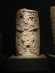
, the largest total in the region. Most are in paired sets representing rulers and their wives. However, because these carved stelae were produced in soft limestone, most of these stelae have been eroded beyond interpretation. Also many elaborate murals were discovered at Calakmul. These murals do not represent activities of the elite class. Rather, they depict elaborate market scenes of people preparing or consuming products such as atole, tamales, or tobacco as an ointment. Also items being sold were textiles and needles. These murals also have glyphs within them describing the actions occurring. The most prominent figure in these murals is identified as Lady Nine Stone; she appears in many scenes. This brings a world of the Maya marketplace to vibrant life for archaeologists. Another highly beneficial resource to Maya archaeological understanding at Calakmul is the ceramic remains. The composition of the ceramic materials identifies the region or more specifically the polity that produced them. Ceramics with the snake emblem glyph found at several sites also give more evidence to identify ties or control over that site by Calakmul.
Stela 1 is associated with an altar and located by Structure 8.
Stela 8 records the celebration of an event in AD 593 by Uneh Chan and was erected after his death.
Stela 9 is a thin slate
monument dated to 662. Its text describes the birth of king Yuknoom Yich'aak K'ak' and gives him his full royal title.
Stela 28 and Stela 29 were erected in 623 and are the earliest monuments to survive from Late Classic Calakmul. They depict a royal couple but the texts are too poorly preserved to reveal their names.
Stela 33 was erected by Yuknoom Che'en II in 657 and records an event in the reign of Uneh Chan, who may have been his father. The event was celebrated in 593.
Stela 38 stands at the base of Structure 2.
Stela 42 is also located at the base of Structure 2.
Stela 43 dates to AD 514. It was set in a vaulted chamber near the base of Structure 2. The text is damaged but carries an early spelling of the k'uhul chatan winik non-royal noble title used in Calakmul and the Mirador Basin.
Stela 50 is one of the last monuments erected during the final decline of the city. It bears a crude, clumsily executed portrait.
Stela 51 is the best preserved monument at Calakmul. It depicts Yuknoom Took' K'awiil and dates to AD 731.
Stela 54 dates to 731 and depicts a wife of Yuknoom Took' K'awiil.
Stela 57 is a tall stela erected in 771 by B'olon K'awiil. It is paired with Stela 58 and stands to the east of Structure 13.
Stela 58 is the second of a pair erected by B'olon K'awiil in 771, the other being Stela 57. It was erected to the east of Structure 13.
Stela 61 is a late monument bearing the name Aj Took'. It is a stunted stela with a badly eroded portrait and a shortened date form that is equivalent to a date either in 899 or 909, probably the latter.
Stela 62 was unfinished. It was carved to mark the K'atun-ending ceremony of 751 and bears the damaged name of Ruler Z.
Stela 76 and Stela 78 are a pair of monuments dated to AD 633. They are badly eroded but should date to the reign of king Yuknoom Head.
Stela 84 is one of the last monuments erected at Calakmul and bears an inscription that is an illiterate imitation of writing. It probably dates to the early 10th century AD.
Stela 88 may have been paired with Stela 62. The monument has the image of a queen but her name is unknown. B'olon K'awiil also appears to be mentioned on the stela. It dates to around 751 and stands on the stairway of Structure 13.
Stela 91 is another very late monument probably dating to the early 10th century. Like Stela 84, it bears an inscription that is a meaningless imitation of hieroglyphic writing.
Stela 114 dates to AD 435, in the Early Classic. It was moved in antiquity to be reset into the base of Structure 2. The stela has a long hieroglyphic text that has resisted translation but probably commemorates a royal enthronement in 411.
Stela 115 and Stela 116 date to the reign of Yuknoom Yich'aak K'ak'. They were broken and buried in Structure 2 and may be associated with the royal burial in Tomb 4.
. The tomb contained rich offerings that included jade ear ornaments handed down from the Early Classic, a jade mosaic mask, shell and bone beads, spiny oyster shells, eccentric obsidian blades, fine ceramics and the remains of wooden objects. One of the ceramics was a plate with a hieroglyphic text that specifically named king Yuknoom Yich'aak K'ak' as its owner. The remains and the offering were placed in an arched wooden bier carved with elaborate decoration and hieroglyphs that was painted in a variety of colours. The bier has almost completely decayed but left an impression in the mud packed around it. Due to the plate and the possible association of Stelae 115 and 116 with the burial the tomb is believed to be that of the late 7th century king Yuknoom Yich'aak K'ak'.
Maya civilization
The Maya is a Mesoamerican civilization, noted for the only known fully developed written language of the pre-Columbian Americas, as well as for its art, architecture, and mathematical and astronomical systems. Initially established during the Pre-Classic period The Maya is a Mesoamerican...
archaeological site in the Mexican state of Campeche
Campeche
Campeche is one of the 31 states which, with the Federal District, comprise the 32 Federal Entities of Mexico. Located in Southeast Mexico, it is bordered by the states of Yucatán to the north east, Quintana Roo to the east, and Tabasco to the south west...
, deep in the jungles of the greater Petén Basin
Petén Basin
The Petén Basin is a geographical subregion of Mesoamerica, located in the northern portion of the modern-day nation of Guatemala, and essentially contained within the department of El Petén...
region. It is 35 kilometres (21.7 mi) from the Guatemala
Guatemala
Guatemala is a country in Central America bordered by Mexico to the north and west, the Pacific Ocean to the southwest, Belize to the northeast, the Caribbean to the east, and Honduras and El Salvador to the southeast...
n border. Calakmul was one of the largest and most powerful ancient cities
Maya city
A Maya city was a centre of population of the pre-Columbian Maya civilization of Mesoamerica. It served the specialised roles of administration, commerce, manufacturing and religion that characterised ancient cities worldwide...
ever uncovered in the Maya
Maya civilization
The Maya is a Mesoamerican civilization, noted for the only known fully developed written language of the pre-Columbian Americas, as well as for its art, architecture, and mathematical and astronomical systems. Initially established during the Pre-Classic period The Maya is a Mesoamerican...
lowlands. Calakmul is a modern name, in ancient times the city core was known as Ox Te' Tuun.
Calakmul was a major Maya power within the northern Peten
Petén Basin
The Petén Basin is a geographical subregion of Mesoamerica, located in the northern portion of the modern-day nation of Guatemala, and essentially contained within the department of El Petén...
region of the Yucatan
Yucatán
Yucatán officially Estado Libre y Soberano de Yucatán is one of the 31 states which, with the Federal District, comprise the 32 Federal Entities of Mexico. It is divided in 106 municipalities and its capital city is Mérida....
of southern Mexico. Calakmul administered a large domain marked by the extensive distribution of their emblem glyph of the snake head sign, to be read "Kaan". Calakmul was the seat of what has been dubbed the Kingdom of the Snake or Snake Kingdom. This Snake Kingdom reigned during most of the Classic period
Mesoamerican chronology
Mesoamerican chronology divides the history of pre-Columbian Mesoamerica into several periods: the Paleo-Indian , the Archaic , the Preclassic , the Classic , and the Postclassic...
. Calakmul itself is estimated to have had a population of 50,000 people and had governance, at times, over places as far away as 150 kilometers. There are 6,750 ancient structures identified at Calakmul the largest of which is the great pyramid at the site. Structure 2 is over 45 metres (147.6 ft) high, making it one of the tallest of the Maya pyramids
Mesoamerican pyramids
Mesoamerican pyramids, pyramid-shaped structures, are an important part of ancient Mesoamerican architecture. These structures were usually step pyramids with temples on top – more akin to the ziggurats of Mesopotamia than to the pyramids of Ancient Egypt...
. Four tombs have been located within the pyramid. Like many temples or pyramids within Mesoamerica
Mesoamerica
Mesoamerica is a region and culture area in the Americas, extending approximately from central Mexico to Belize, Guatemala, El Salvador, Honduras, Nicaragua, and Costa Rica, within which a number of pre-Columbian societies flourished before the Spanish colonization of the Americas in the 15th and...
the pyramid at Calakmul increased in size by building upon the existing temple to reach its current size. The size of the central monumental architecture
Maya architecture
A unique and spectacular style, Maya architecture spans several thousands of years. Often the most dramatic and easily recognizable as Maya are the stepped pyramids from the Terminal Pre-classic period and beyond. Being based on the general Mesoamerican architectural traditions these pyramids...
is approximately 2 square kilometre (0.77220431718507 sq mi) and the whole of the site, mostly covered with dense residential structures, is about 20 square kilometres (7.7 sq mi).
Throughout the Classic Period, Calakmul maintained an intense rivalry with the major city of Tikal
Tikal
Tikal is one of the largest archaeological sites and urban centres of the pre-Columbian Maya civilization. It is located in the archaeological region of the Petén Basin in what is now northern Guatemala...
to the south, and the political manoeuvrings of these two cities have been likened to a struggle between two Maya superpowers.
Rediscovered from the air by biologist Cyrus L. Lundell of the Mexican Exploitation Chicle Company on December 29, 1931, the find was reported to Sylvanus G. Morley
Sylvanus Morley
Sylvanus Griswold Morley was an American archaeologist, epigrapher, and Mayanist scholar who made significant contributions toward the study of the pre-Columbian Maya civilization in the early twentieth century....
of the Carnegie Institute
Carnegie Institution for Science
The Carnegie Institution for Science is an organization in the United States established to support scientific research....
at Chichen Itza
Chichen Itza
Chichen Itza is a large pre-Columbian archaeological site built by the Maya civilization located in the northern center of the Yucatán Peninsula, in the Municipality of Tinúm, Yucatán state, present-day Mexico....
in March 1932. According to Lundell, who named the site, "In Maya, 'ca' means 'two', 'lak' means 'adjacent', and 'mul' signifies any artificial mound or pyramid, so 'Calakmul' is the 'City of the Two Adjacent Pyramids'."
Location
Calakmul is located in CampecheCampeche
Campeche is one of the 31 states which, with the Federal District, comprise the 32 Federal Entities of Mexico. Located in Southeast Mexico, it is bordered by the states of Yucatán to the north east, Quintana Roo to the east, and Tabasco to the south west...
state in southeastern Mexico, about 35 kilometres (21.7 mi) north of the border with Guatemala
Guatemala
Guatemala is a country in Central America bordered by Mexico to the north and west, the Pacific Ocean to the southwest, Belize to the northeast, the Caribbean to the east, and Honduras and El Salvador to the southeast...
and 38 kilometres (23.6 mi) north of the ruins of El Mirador
El Mirador
El Mirador is a large pre-Columbian Mayan settlement, located in the north of the modern department of El Petén, Guatemala.-Discovery:El Mirador was first discovered in 1926, and was photographed from the air in 1930, but the remote site deep in the jungle had little more attention paid to it until...
. The ruins of El Tintal
El Tintal
El Tintal is a Maya archaeological site in the northern Petén region of Guatemala, about northeast of the modern-day settlement of Carmelita, with settlement dating to the Preclassic and Classic periods. It is close to the better known sites of El Mirador , to which it was linked by causeway,...
are 68 kilometres (42.3 mi) to the southwest of Calakmul and were linked to both El Mirador and Calakmul itself by causeway. Calakmul was about 20 kilometres (12.4 mi) south of the contemporary city of Oxpemul and approximately 25 kilometres (15.5 mi) southwest of La Muñeca. The city is located on a rise about 35 metres (114.8 ft) above a large seasonal swamp
Wetland
A wetland is an area of land whose soil is saturated with water either permanently or seasonally. Wetlands are categorised by their characteristic vegetation, which is adapted to these unique soil conditions....
lying to the west, known as the El Laberinto bajo (a Spanish
Spanish language
Spanish , also known as Castilian , is a Romance language in the Ibero-Romance group that evolved from several languages and dialects in central-northern Iberia around the 9th century and gradually spread with the expansion of the Kingdom of Castile into central and southern Iberia during the...
word used in the region to denote a low-lying area of seasonal marshland). This swamp measures approximately 34 by and was an important source of water during the rain season. The bajo was linked to a sophisticated water-control system including both natural and artificial features such as gullies and canals that encircled a 22 square kilometres (8.5 sq mi) area around the site core, an area considered as Inner Calakmul. The location of Calakmul at the edge of a bajo provided two additional advantages: the fertile soils along the edge of the swamp and access to abundant flint
Flint
Flint is a hard, sedimentary cryptocrystalline form of the mineral quartz, categorized as a variety of chert. It occurs chiefly as nodules and masses in sedimentary rocks, such as chalks and limestones. Inside the nodule, flint is usually dark grey, black, green, white, or brown in colour, and...
nodules
Nodule (geology)
A nodule in petrology or mineralogy is a secondary structure, generally spherical or irregularly rounded in shape. Nodules are typically solid replacement bodies of chert or iron oxides formed during diagenesis of a sedimentary rock...
. The city is situated on a promontory formed by a natural 35 metres (114.8 ft) high limestone
Limestone
Limestone is a sedimentary rock composed largely of the minerals calcite and aragonite, which are different crystal forms of calcium carbonate . Many limestones are composed from skeletal fragments of marine organisms such as coral or foraminifera....
dome rising above the surrounding lowlands. This dome was artificially levelled by the Maya. During the Preclassic
Mesoamerican chronology
Mesoamerican chronology divides the history of pre-Columbian Mesoamerica into several periods: the Paleo-Indian , the Archaic , the Preclassic , the Classic , and the Postclassic...
and Classic periods settlement was concentrated along the edge of the El Laberinto bajo, during the Classic period structures were also built on high ground and small islands in the swamp where flint was worked.
At the beginning of the 21st century the area around Calakmul remained covered by dense forest. During the 1st millennium AD the area received moderate and regular rainfall, although there is less surface water available than further south in Guatemala. Calakumul is now located within the 1800000 acres (7,284.3 km²) Calakmul Biosphere Reserve
Calakmul Biosphere Reserve
The Calakmul Biosphere Reserve is located at the base of the Yucatán Peninsula in Mexico, in Calakmul Municipality in the state of Campeche, bordering the Guatemalan department of El Petén to the south. It occupies 7,231.85 km² and includes about 12% of the subperennial jungles of Mexico. Its...
.
Population and extent
At its height in the Late Classic period the city is estimated to have had a population of 50,000 inhabitants and to have covered an area of over 70 square kilometres (27 sq mi). The city was the capital of a large regional state with an area of about 13000 square kilometres (5,019.3 sq mi). During the Terminal Classic the city's population declined dramatically and the rural population plummeted to 10% of its former level.The Late Classic population density of Calakmul has been calculated at 1000/km² (2564 per square mile) in the site core and 420/km² (1076 per square mile) in the periphery (an area of 122 square kilometres (47.1 sq mi). Calakmul was a true urban city and not just an elite centre surrounded by commoner residences. The site core of Calakmul was known in ancient times as Ox Te' Tuun ("Place of Three Stones") which may have been because of the triadic pyramid
Triadic pyramid
Triadic pyramids are a Preclassic Maya civilization innovation consisting of a dominant structure flanked by two smaller inward-facing buildings, all mounted upon a single basal platform...
Structure 2.
The Calakmul kingdom included 20 secondary centres, among which were large cities such as La Muñeca, Naachtun
Naachtun
Naachtun is an archaeological site of the pre-Columbian Maya civilization, situated at the northeastern perimeter of the Mirador Basin region in the southern Maya lowlands, now in the modern-day Department of El Petén, northern Guatemala...
, Sasilha, Oxpemul and Uxul. The total population of these secondary centres has been estimated at 200,000. The kingdom also included a large number of tertiary and quaternary sites, mostly fairly small and consisting of a number of groups arranged around courtyards, although there are also larger rural sites situated on ridges along the edges of the bajos that include temples, palaces and stelae. The total rural population of the kingdom is calculated at 1.5 million people. The entire population of the Calakmul kingdom, including the city itself and the rural population in the 13000 square kilometres (5,019.3 sq mi) area of the regional state, is calculated at 1.75 million people in the Late Classic period.
The Emblem Glyph of Calakmul has a greater distribution than the Emblem Glyph of any other Maya city. The Glyph is also found in more hieroglyphic texts than any other Emblem Glyph, including that of Tikal. Calakmul administered a large domain marked by the extensive distribution of their emblem glyph of the snake head sign, to be read "Kaan". Calakmul was the seat of what has been dubbed the Snake Kingdom. At times the city had governance over places as far away as 150 kilometers.
Known rulers
Ajaw
Ajaw is a political rulership title attested from the epigraphic inscriptions of the pre-Columbian Maya civilization, with a meaning variously interpreted as "lord", "ruler", "king" or "leader". It denoted any of the leading class of nobles in a particular polity and was not limited to a single...
ob ("Divine Lords of the Snake Kingdom"). This list is not continuous, as the archaeological record is incomplete. All dates AD.
| Name (or nickname) | Ruled | Alternative Names |
|---|---|---|
| Yuknoom Ch'een I | ? | – |
| Tuun K'ab' Hix | -520-546+ | Cu Ix, Ku Ix |
| Sky Witness | -561-572+ | – |
| First Axewielder | 572-579 | – |
| Uneh Chan | 579-611+ | Scroll Serpent |
| Yuknoom Chan | –619+ | Chan |
| Tajoom Uk'ab' K'ak' | 622-630 | Ta Batz' |
| Yuknoom Head | 630-636 | Cauac Head |
| Yuknoom Ch'een II | 636–686 | Yuknoom the Great, Yuknom Ch'en |
| Yuknoom Yich'aak K'ak' | 686–c. 695 | Jaguar Paw Smoke, Jaguar Paw |
| Split Earth | c. 695+ | – |
| Yuknoom Took' K'awiil | -702–731+ | Ruler 5, Ruler 6, Ruler 7 |
| Wamaw K'awiil | c. 736 | – |
| Ruler Y | c. 741 | Ruler 8, B'olon K'awiil I |
| Ruler Z | c. 751 | Ruler 8 |
| B'olon K'awiil | -771-c. 789+ | Ruler 9, B'olon K'awiil II |
| Chan Pet | c. 849 | – |
| Aj Took' | c. 909 | – |
History
Calakmul has a long occupational history and excavations have revealed evidence from the Middle Preclassic right through to the PostclassicMesoamerican chronology
Mesoamerican chronology divides the history of pre-Columbian Mesoamerica into several periods: the Paleo-Indian , the Archaic , the Preclassic , the Classic , and the Postclassic...
. The causeway network that linked Calakmul with the cities of El Mirador, Nakbe and El Tintal suggest strong political links between the four cities that may have begun in the Preclassic, when both Calakmul and El Mirador where important cities, and continued into the Classic period when Calakmul itself was the most powerful city in the region. Calakmul was one of the largest and most powerful ancient cities
Maya city
A Maya city was a centre of population of the pre-Columbian Maya civilization of Mesoamerica. It served the specialised roles of administration, commerce, manufacturing and religion that characterised ancient cities worldwide...
ever uncovered in the Maya
Maya civilization
The Maya is a Mesoamerican civilization, noted for the only known fully developed written language of the pre-Columbian Americas, as well as for its art, architecture, and mathematical and astronomical systems. Initially established during the Pre-Classic period The Maya is a Mesoamerican...
lowlands.
Calakmul vs. Tikal
The history of the Maya Classic period is dominated by the rivalry between Tikal and Calakmul, likened to a struggle between two Maya "superpowers". Earlier times tended to be dominated by a single larger city and by the Early Classic Tikal was moving into this position after the dominance of El Mirador in the Late Preclassic and NakbeNakbe
Nakbe is one of the largest early Maya archaeological sites, rivaled by El Mirador. Nakbe is located in the The Mirador Basin, in El Petén region of Guatemala, approximately 13 kilometers south of the Largest Maya city of El Mirador...
in the Middle Preclassic. However Calakmul was a rival city with equivalent resources that challenged the supremacy of Tikal and engaged in a strategy of surrounding it with its own network of allies. From the second half of the 6th century AD through to the late 7th century Calakmul gained the upper hand although it failed to extinguish Tikal's power completely and Tikal was able to turn the tables on its great rival in a decisive battle that took place in AD 695. Half a century later Tikal was able to gain major victories over Calakmul's most important allies. Eventually both cities succumbed to the spreading Classic Maya collapse
Classic Maya collapse
The Classic Maya Collapse refers to the decline and abandonment of the Classic Period Maya cities of the southern Maya lowlands of Mesoamerica between the 8th and 9th centuries. This should not be confused with the collapse of the Preclassic Maya in the 2nd century AD...
.
The great rivalry between these two cities may have been based on more than competition for resources. Their dynastic histories reveal different origins and the intense competition between the two powers may have had an ideological grounding. Calakmul's dynasty seems ultimately derived from the great Preclassic city of El Mirador while the dynasty of Tikal was profoundly affected by the intervention of the distant central Mexican metropolis of Teotihuacan
Teotihuacan
Teotihuacan – also written Teotihuacán, with a Spanish orthographic accent on the last syllable – is an enormous archaeological site in the Basin of Mexico, just 30 miles northeast of Mexico City, containing some of the largest pyramidal structures built in the pre-Columbian Americas...
. With few exceptions, Tikal's monuments and those of its allies place great emphasis upon single male rulers while the monuments of Calakmul and its allies gave greater prominence to the female line and often the joint rule of king and queen.
Preclassic
Calakmul was already a large city in the Preclassic period. The early history of Calakmul is obscure, although a dynastic list has been pieced together that extends back into an ancestral past. This dynasty has been reconstructed in part from Late Classic ceramics from the region of great Preclassic cities of El Mirador and Nakbe. This may mean that Calakmul ultimately inherited its political authority from one of these cities, with its dynasty originating in the Late Preclassic in the Mirador BasinMirador Basin
The Mirador Basin is a geological depression found in the remote rainforest of the northern department of Petén, Guatemala. Mirador Basin consists of two true basins, consisting of shallowly sloping terrain dominated by low-lying swamps called bajos; one draining into the San Pedro River and the...
and relocating itself to Calakmul in the Classic period after the collapse of these cities.
Early Classic
Both Calakmul and Tikal were sizeable Preclassic cities that survived into the Classic Period. Early hieroglyphic textsMaya script
The Maya script, also known as Maya glyphs or Maya hieroglyphs, is the writing system of the pre-Columbian Maya civilization of Mesoamerica, presently the only Mesoamerican writing system that has been substantially deciphered...
from stelae
Stele
A stele , also stela , is a stone or wooden slab, generally taller than it is wide, erected for funerals or commemorative purposes, most usually decorated with the names and titles of the deceased or living — inscribed, carved in relief , or painted onto the slab...
found in Structure 2 record the probable enthronement of a king of Calakmul in AD 411 and also records a non-royal site ruler in 514. After this there is a gap in the hieroglyphic records that lasts over a century, although the Kaan dynasty experienced a major expansion of its power at this time. The lack of inscriptions recording the events of this period may be either due to the fact that the Kaan dynasty was located elsewhere during this time or perhaps that the monuments were later destroyed.
The earliest legible texts referring to the kings of the Kaan dynasty come from excavations of the large city of Dzibanche in Quintana Roo
Quintana Roo
Quintana Roo officially Estado Libre y Soberano de Quintana Roo is one of the 31 states which, with the Federal District, comprise the 32 Federal Entities of Mexico. It is divided in 10 municipalities and its capital city is Chetumal....
, far north of Calakmul. A hieroglyphic stairway depicts bound captives, their names and the dates they were captured together with the name of king Yuknoom Che'en I, although the exact context of the king's name is unclear - the captives may have been his vassals captured by an enemy or they may have been rulers captured by the king of Calakmul. The dates are uncertain but two of them may fall within the 5th century AD. The nearby Quintana Roo site of El Resbalón has a jumbled hieroglyphic text, including a date in 529, that indicates that the city was within the control of the Kaan dynasty.
By the middle of the 6th century AD Calakmul was assembling a far-reaching political alliance, activity that brought the city into conflict with the great city of Tikal. The influence of Calakmul extended deep into the Petén
Petén Basin
The Petén Basin is a geographical subregion of Mesoamerica, located in the northern portion of the modern-day nation of Guatemala, and essentially contained within the department of El Petén...
; king Tuun K'ab' Hix of Calakmul oversaw the enthronement of Aj Wosal to the rulership of Naranjo
Naranjo
Naranjo is an ancient city of the Maya civilization in the Petén Basin region of the central Maya lowlands. It is located in the present-day department of Petén, Guatemala about 10 km west of the border with Belize. It is located within the area of the Cultural Triangle of Yaxha, Nakum, Naranjo...
in 546. Another vassal of Tuun K'ab' Hix was taken captive by Yaxchilán
Yaxchilan
Yaxchilan is an ancient Maya city located on the bank of the Usumacinta River in what is now the state of Chiapas, Mexico. In the Late Classic Period Yaxchilan was one of the most powerful Maya states along the course of the Usumacinta, with Piedras Negras as its major rival...
on the banks of the Usumacinta River
Usumacinta River
The Usumacinta River is a river in southeastern Mexico and northwestern Guatemala. It is formed by the junction of the Pasión River, which arises in the Sierra de Santa Cruz and the Salinas River, also known as the Chixoy, or the Negro, which descends from the Sierra Madre de Guatemala...
in 537.
In 561, the king now known as Sky Witness
Sky Witness
"Sky Witness" was a ruler of the Maya city and major cultural center of Calakmul, also known as Kaan. He took the rulership some time prior to the year 561, and led Kaan into a war with rival Maya city-state Tikal , winning a major victory in 562 which broke Mutal's formerly extensive power in the...
installed a ruler at the site of Los Alacranes. Sky Witness played a major part in the political events of the Maya region, he became the overlord of the city of Caracol
Caracol
Caracol is the name given to a large ancient Maya archaeological site, located in what is now the Cayo District of Belize. It is situated approximately 40 kilometres south of Xunantunich and the town of San Ignacio Cayo, and 15 kilometers away from the Macal River. It rests on the Vaca Plateau at...
, to the south of Naranjo, which had previously been a vassal of Tikal. In 562, according to a damaged text at Caracol, Sky Witness defeated Tikal itself and sacrificed its king Wak Chan K'awiil, thus ending his branch of the royal dynasty at Tikal. This catastrophic defeat began a 130 year hiatus for Tikal, reflecting an extended period of dominance by Calakmul. This event is used as a marker to divide the Early Classic from the Late Classic. Sky Witness is also mentioned at Okop
Yo'okop
Yo'okop is an ancient Maya city located in the Cochuah region of central Quintana Roo, Mexico. This area is best known as the epicenter of the Caste War of Yucatán waged during the 19th century, that resulted in an independent Maya state governed from the city of Chan Santa Cruz.The site was first...
, a site much further north in Quintana Roo. The last reference to Sky Witness occurs at Caracol and is dated to AD 572. The text is damaged but probably records the death of this powerful king.
War with Palenque
Sky WitnessSky Witness
"Sky Witness" was a ruler of the Maya city and major cultural center of Calakmul, also known as Kaan. He took the rulership some time prior to the year 561, and led Kaan into a war with rival Maya city-state Tikal , winning a major victory in 562 which broke Mutal's formerly extensive power in the...
was quickly succeeded by First Axewielder, who is mentioned in a text from Dzibanche celebrating the K'atun-ending of 573. First Axewielder ruled for about six years. In 579 Uneh Chan became king of Calakmul. Uneh Chan engaged in an aggressive campaign in the western Maya region and attacked Palenque
Palenque
Palenque was a Maya city state in southern Mexico that flourished in the 7th century. The Palenque ruins date back to 100 BC to its fall around 800 AD...
on 23 April 599 with his ally Lakam Chak, lord of the small city of Santa Elena 70 kilometres (43.5 mi) east of Palenque, defeating Palenque's queen Lady Yohl Ik'nal and sacking the city. The defeat is recorded on a series of hieroglyphic steps at Palenque itself and the event initiated a long-lasting grudge against Calakmul. Lady Yohl Ik'nal survived the battle and ruled for several more years, although she perhaps paid tribute to Calakmul.
Uneh Chan maintained his alliances with cities in the east and he is depicted on Caracol Stela 4 supervising an event involving king Yajaw Te' K'inich of that city that occurred before 583. Calakmul again sacked Palenque on 7 April 611 under the personal direction of Uneh Chan. Palenque was now ruled by king Ajen Yohl Mat who had gained some sort of independence from Calakmul, provoking the new invasion. The immediate aftermath of this second victory over Palenque involved the deaths of the two most important nobles at the city, Ajen Yohl Mat himself and Janab Pakal, a high ranking member of the royal family and possibly co-ruler. Janab Pakal died in March 612 and Ajen Yohl Mat a few months later. Their deaths so soon after the sacking of the city suggests that their demise was directly linked to Calakmul's triumph. Palenque suffered a lengthy decline in its fortunes after this date before it was able to recover from its disastrous war
Maya warfare
Although the Maya were once thought to have been peaceful , current theories emphasize the role of inter-polity warfare as a factor in the development and perpetuation of Maya society. The goals and motives of warfare in Maya culture are not thoroughly understood, but there are several kinds of...
with Calakmul. The wars against Palenque may have been undertaken by Uneh Chan in order to seize control of wealthy trade routes that passed through the western Maya region.
Rebellion at Naranjo
King Yuknoom Chan of Calakmul supervised an event at Caracol in 619. Caracol Stela 22 records the accession of Tajoom Uk'ab' K'ak' to the Calakmul throne in 622. Two stelae were erected at Calakmul in 623 but their texts are too badly damaged to reveal the names of the royal couple involved. Approximately at this time Naranjo, a vassal of Calakmul, broke away when its king Aj Wosal died relatively soon after the death of Uneh Chan of Calakmul. Naranjo was independent of Calakmul by at least AD 626, when it was twice defeated by Caracol and Yuknoom Chan may have been attempting to bring Naranjo back under Calakmul control. His attempts were brought to an end by his death in 630. In 631 Yuknoom Head, the new king of Calakmul, finally regained control of Naranjo. Texts relate that the king of Naranjo was already captive at Calakmul on the day that his city was overrun and his punishment on the very same day is described by the word k'uxaj meaning either "tortured" or "eaten". Yuknoom Head conquered another city in March 636, although the exact site is unknown.Apogee
Calakmul experienced its highest achievements during the reign of king Yuknoom Che'en II, sometimes called Yuknoom the Great by scholars. Yuknoom Che'en II was 36 years old when he came to the throne of Calakmul in AD 636. A significant increase in the production of stelae at the city began with his reign and 18 stelae were commissioned by the king. Yuknoom Che'en II was probably responsible for the construction of the palace complexes that form a major part of the site core.Calakmul and Dos Pilas
In 629 Tikal had founded Dos Pilas
Dos Pilas
Dos Pilas is a Pre-Columbian site of the Maya civilization located in what is now the department of Petén, Guatemala. It dates to the Late Classic Period, being founded by an offshoot of the dynasty of the great city of Tikal in AD 629 in order to control trade routes in the Petexbatún region,...
in the Petexbatún
Petexbatún
Petexbatún is a small lake formed by a river of the same name, which is a tributary of the La Pasion river. It is near Sayaxché, located in the southern area of the Guatemalan department of Petén....
region, some 110 kilometres (68.4 mi) to its southwest, as a military outpost in order to control trade along the course of the Pasión River
Pasión River
The Pasión River is a river located in the northern lowlands region of Guatemala. The river is fed by a number of upstream tributaries whose sources lie in the hills of Alta Verapaz. These flow in a general northerly direction to form the Pasión, which then tends westwards to meet up with the...
. B'alaj Chan K'awiil was installed on the throne of the new outpost at the age of four, in 635, and for many years served as a loyal vassal fighting for his brother, the king of Tikal. In AD 648 Calakmul attacked Dos Pilas and gained an overwhelming victory that included the death of a Tikal lord. B'alaj Chan K'awiil was captured by Yuknoom Che'en II but, instead of being sacrificed, he was re-instated on his throne as a vassal of the Calakmul king, and went on to attack Tikal in 657, forcing Nuun Ujol Chaak, the then king of Tikal, to temporarily abandon the city. The first two rulers of Dos Pilas continued to use the Mutal emblem glyph of Tikal, and they probably felt that they had a legitimate claim to the throne of Tikal itself. For some reason, B'alaj Chan K'awiil was not installed as the new ruler of Tikal; instead he stayed at Dos Pilas. Tikal counterattacked against Dos Pilas in 672, driving B'alaj Chan K'awiil into an exile that lasted five years. Calakmul tried to encircle Tikal within an area dominated by its allies, such as El Peru, Dos Pilas and Caracol. In 677 Calakmul counterattacked against Dos Pilas, driving Tikal out and reinstalled B'alaj Chan K'awiil on his throne. In 679 Dos Pilas, probably aided by Calakmul, gained an important victory over Tikal, with a hieroglyphic description of the battle describing pools of blood and piles of heads.
Troubles continued in the east, with renewed conflict between Naranjo and Caracol. Naranjo completely defeated Caracol in 680 but Naranjo's dynasty disappeared within two years and a daughter of B'alaj Chan K'awiil founded a new dynasty there in 682, indicating that Calakmul had probably intervened decisively to place a loyal vassal on the throne. The patronage of Yuknoom Che'en II as overlord is recorded at a range of important cities, including El Peru where he oversaw the installation of K'inich B'alam as king and strengthened the tie with the marriage of a Calakmul princess to that king. The power of Calakmul extended as far as the north shore of Lake Petén Itzá
Lake Petén Itzá
Lake Petén Itzá is a lake in the northern department Petén in Guatemala. It is the second largest lake in Guatemala, the Izabal lake being the largest. It is located around . It has an area of 99 km² some 32 km. long and 5 km wide. Its maximum depth is 160 m...
, where Motul de San José
Motul de San José
Motul de San José is an ancient Maya site located just north of Lake Petén Itzá in the Petén Basin region of the southern Maya lowlands. It is located a few kilometres from the modern village of San José, in Guatemala's northern department of Petén...
is recorded as its vassal in the 7th century, although it was traditionally aligned with Tikal. Yuknoom Che'en II commanded the loyalty of three generations of kings at Cancuen
Cancuén
Cancuén is an archaeological site of the pre-Columbian Maya civilization, located in the Pasión subregion of the central Maya lowlands in the present-day Guatemalan Department of El Petén. The city is notable for having one of the largest palaces in the Maya world.- Ancient Cancuén :Cancuén was a...
, 245 kilometres (152.2 mi) to the south, and supervised the enthronement of at least two of them, in 656 and 677. King Yuknoom Che'en II was involved, directly or indirectly, in the crowning of a king at Moral to the west in Tabasco
Tabasco
Tabasco officially Estado Libre y Soberano de Tabasco is one of the 31 states which, with the Federal District, comprise the 32 Federal Entities of Mexico. It is divided in 17 municipalities and its capital city is Villahermosa....
and one of Yuknoom's nobles supervised a ritual at Piedras Negras on the Guatemalan bank of the Usumacinta River
Usumacinta River
The Usumacinta River is a river in southeastern Mexico and northwestern Guatemala. It is formed by the junction of the Pasión River, which arises in the Sierra de Santa Cruz and the Salinas River, also known as the Chixoy, or the Negro, which descends from the Sierra Madre de Guatemala...
. Yuknoom Che'en II died in his eighties, probably at the beginning of 686. When he died, Calakmul was the most powerful city in the central Maya lowlands.
Yuknoom Yich'aak K'ak' succeeded Yuknoom Che'en II, his crowning on 3 April 686 was recorded on monuments at Dos Pilas and El Peru. He was born in 649 and was likely to have been the son of his predecessor. He already held high office before he was named king and may have been responsible for the major successes of the latter part of Yuknoom Che'en II's reign. He retained the loyalty of K'inich B'alam of El Peru and B'alaj Chan K'awiil of Dos Pilas and gained that of K'ak' Tiliw Chan Chaak in 693, when he was installed on the throne of Naranjo at the age of five. However, the texts on sculpted monuments do not reveal the full complexity of diplomatic activity, as revealed by a painted ceramic vase from Tikal, which depicts an ambassador of Calakmul's king kneeling before the enthroned king of Tikal and delivering tribute. Just four years later, in August 695, the two states were once again at war. Yuknoom Yich'aak K'ak' led his warriors against Jasaw Chan K'awiil I in a catastrophic battle that saw the defeat of Calakmul and the capture of the image of a Calakmul deity named Yajaw Maan. It is unknown what happened to Yuknoom Yich'aak K'ak'; a stucco sculpture from Tikal shows a captive and the king is mentioned in the accompanying caption but it is not certain if the captive and the king are the same person. This event marked the end of Calakmul's apogee, with diplomatic activity dropping away and fewer cities recognising Calakmul's king as overlord. No stelae remain standing in the site core recording Yuknoom Yich'aal K'ak, although there are some in the Northeast Group and 2 broken stelae were buried in Structure 2.
Later kings
The next ruler of Calakmul, Split Earth, is mentioned on a pair of carved bones in the tomb of Tikal king Jasaw Chan K'awiil I. He was ruling by November 695 but it is not known if he was a legitimate member of the Calakmul dynasty or whether he was a pretender placed on the throne by Tikal.The next known king used a number of name variants, and is referred to by different name segments within and outside of Calakmul. A partial reading of his name is Yuknoom Took' K'awiil. He erected seven stelae to celebrate a calendrical event in 702 and is named at Dos Pilas in that year, presumably demonstrating that Dos Pilas was still a vassal of Calakmul. El Peru also continued as a vassal and Yuknoom Took' K'awiil installed a new king there at an unknown date. Naranjo also remained loyal. Yuknoom Took' K'awiil commissioned seven more stelae to mark the k'atun-ending of 731. A new defeat at the hands of Tikal is evidenced by a sculpted altar at that city, probably dating to sometime between 733 and 736, depicting a bound lord from Calakmul and possibly names Yuknoom Took' K'awiil.
Calakmul and Quiriguá
After this the historical record of Calakmul becomes very vague, due both to the poor state of the heavily eroded monuments at the city itself and also its reduced political presence on the wider Maya stage. Wamaw K'awiil is named at Quiriguá
Quiriguá
Quiriguá is an ancient Maya archaeological site in the department of Izabal in south-eastern Guatemala. It is a medium-sized site covering approximately along the lower Motagua River, with the ceremonial center about from the north bank. During the Maya Classic Period , Quiriguá was situated at...
on the southern periphery of Mesoamerica. Quiriguá traditionally had been a vassal of its southern neighbour Copán
Copán
Copán is an archaeological site of the Maya civilization located in the Copán Department of western Honduras, not far from the border with Guatemala. It was the capital city of a major Classic period kingdom from the 5th to 9th centuries AD...
, and in 724 Uaxaclajuun Ub'aah K'awiil
Uaxaclajuun Ub'aah K'awiil
Uaxaclajuun Ub'aah K'awiil , was a ruler of the powerful Maya polity associated with the site of Copán in modern Honduras . He ruled from January 2, 695, to May 3, 738...
, king of Copán, installed K'ak' Tiliw Chan Yopaat upon Quiriguá's throne as his vassal. By 734 K'ak' Tiliw Chan Yopaat had shown that he was no longer an obedient subordinate of Copán when he started to refer to himself as k'ul ahaw
Ajaw
Ajaw is a political rulership title attested from the epigraphic inscriptions of the pre-Columbian Maya civilization, with a meaning variously interpreted as "lord", "ruler", "king" or "leader". It denoted any of the leading class of nobles in a particular polity and was not limited to a single...
, holy lord, instead of using the lesser term ahaw, subordinate lord; at the same time he began to use his own Quiriguá emblem glyph. This local act of rebellion appears to have been part of the larger political struggle between Tikal and Calakmul. In 736, only two years later, K'ak' Tiliw Chan Yopaat received a visit from Wamaw K'awiil of Calakmul, while Copán was one of Tikal's oldest allies. The timing of this visit by the king of Calakmul is highly significant, falling between the accession of K'ak' Tiliw Chan Yopaat to the throne of Quiriguá as a vassal of Copán and the outright rebellion that was to follow. This strongly suggests that Calakmul sponsored Quiriguá's rebellion in order to weaken Tikal and to gain access to the rich trade route of the Motagua Valley
Motagua River
The Motagua River is a long river in Guatemala. It rises in the western highlands of Guatemala where it is also called Río Grande, and runs in an easterly direction to the Gulf of Honduras. The final few kilometres of the river form part of the Guatemala/Honduras border...
. It is likely that contact with Calakmul had been initiated soon after K'ak' Tiliw Chan Yopaat acceded to the throne. In 738 K'ak' Tiliw Chan Yopaat captured the powerful but elderly king of Copán, Uaxaclajuun Ub'aah K'awiil. An inscription at Quiriguá, although difficult to interpret, suggests that the capture took place on 27 April 738, when Quiriguá seized and burned the wooden images of Copán's patron deities
Deity
A deity is a recognized preternatural or supernatural immortal being, who may be thought of as holy, divine, or sacred, held in high regard, and respected by believers....
. The captured lord was taken back to Quiriguá and on 3 May 738 he was decapitated in a public ritual.
In the Late Classic, alliance with Calakmul was frequently associated with the promise of military support. The fact that Copán, a much more powerful city than Quiriguá, failed to retaliate against its former vassal implies that it feared the military intervention of Calakmul. Calakmul itself was far enough away from Quiriguá that K'ak' Tiliw Chan Yopaat was not afraid of falling directly under its power as a full vassal state, even though it is likely that Calakmul sent warriors to help in the defeat of Copán. The alliance instead seems to have been one of mutual advantage: Calakmul managed to weaken a powerful ally of Tikal while Quiriguá gained its independence.
Collapse
Five large stelae were raised in 741, although the name of the king responsible is illegible on all of them and he has been labelled as Ruler Y. Calakmul's presence in the wider Maya area continued to wane, with two of the city's major allies suffering defeats at the hands of Tikal. El Peru was defeated in 743 and Naranjo a year later and this resulted in the final collapse of Calakmul's once powerful alliance network, while Tikal underwent a resurgence in its power.In 751 Ruler Z erected a stela that was never finished, paired with another with the portrait of a queen. A hieroglyphic stairway mentions someone called B'olon K'awiil at about the same time. B'olon K'awiil was king by 771 when he raised two stelae and he was mentioned at Toniná in 789. Sites to the north of Calakmul showed a reduction in its influence at this time, with new architectural styles influenced by sites further north in the Yucatán Peninsula
Yucatán Peninsula
The Yucatán Peninsula, in southeastern Mexico, separates the Caribbean Sea from the Gulf of Mexico, with the northern coastline on the Yucatán Channel...
.
A monument was raised in 790 although the name of the ruler responsible is not preserved. Two more were raised in 800 and three in 810. No monument was erected to commemorate the important Bak'tun
Baktun
A baktun is 20 katun cycles of the ancient Maya Long Count Calendar. It contains 144,000 days, equivalent to 394.26 tropical years. The Classic period of Maya civilization occurred during the 8th and 9th baktuns of the current calendrical cycle. The current baktun will end, or be completed, on...
-ending of 830 and it is probable that political authority had alreadly collapsed at this time. Important cities such as Oxpemul, Nadzcaan and La Muñeca that were Calakmul's vassals at one time now erected their own monuments, where before they had raised very few, some continued producing new monuments until as late as 889. This was a process that paralleled events at Tikal. However, there is strong evidence of an elite presence at the city continuing until AD 900, possibly even later.
In 849, Calakmul was mentioned at Seibal
Seibal
Seibal, known as El Ceibal in Spanish, is a Classic Period archaeological site of the Maya civilization located in the northern Petén Department of Guatemala. It was the largest city in the Pasión River region....
where a ruler named as Chan Pet attended the K'atun-ending ceremony; his name may also be recorded on a broken ceramic at Calakmul itself. However, it is unlikely that Calakmul still existed as a state in any meaningful way at this late date. A final flurry of activity took place at the end of the 9th century or the beginning of the 10th. A new stela was erected, although the date records only the day, not the full date. The recorded day may fall either in 899 or 909 with the latter date the most likely. A few monuments appear to be even later although their style is crude, representing the efforts of a remnant population to maintain the Classic Maya tradition. Even the inscriptions on these late monuments are meaningless imitations of writing.
Ceramics dating to the Terminal Classic period are uncommon outside of the site core, suggesting that the population of the city was concentrated in the city centre in the final phase of Calakmul's occupation. The majority of the surviving population probably consisted of commoners who had occupied the elite architecture of the site core but the continued erection of stelae into the early 10th century and the presence of high status imported goods such as metal, obsidian, jade and shell, indicate a continued occupation by royalty until the final abandonment of the city.
Modern history
Calakmul was first reported by Cyrus Lundell in 1931. A year later he informed Sylvanus MorleySylvanus Morley
Sylvanus Griswold Morley was an American archaeologist, epigrapher, and Mayanist scholar who made significant contributions toward the study of the pre-Columbian Maya civilization in the early twentieth century....
of the site's existence and the presence of more than 60 stelae. Morley visited the ruins himself on behalf of the Carnegie Institution of Washington
Carnegie Institution for Science
The Carnegie Institution for Science is an organization in the United States established to support scientific research....
in 1932. In the 1930s surveys mapped the site core and recorded 103 stelae. Investigations stopped in 1938 and archaeologists did not return to the site until 1982 when William J. Folan directed a project on behalf of the Universidad Autónoma de Campeche, working at Calakmul until 1994. Calakmul is now the subject of a large-scale project of the National Institute of Anthropology and History
National Institute of Anthropology and History
The Instituto Nacional de Antropología e Historia is a Mexican federal government bureau established in 1939 to guarantee the research, preservation, protection, and promotion of the prehistoric, archaeological, anthropological, historical, and paleontological heritage of Mexico...
(INAH) under the direction of Ramón Carrasco.
Site description
The site core of Calakmul covers an area of approximately 2 square kilometre (0.77220431718507 sq mi), an area that contains the remains of roughly 1000 structures. The periphery occupied by smaller residential structures beyond the site core covers an area of more than 20 square kilometres (7.7 sq mi) within which archaeologists have mapped approximately 6250 structures. Calakmul matches the great city of Tikal in size and estimated population, although the density of the city appears to have been greater than that city.The stone used in construction at the site is a soft limestone
Limestone
Limestone is a sedimentary rock composed largely of the minerals calcite and aragonite, which are different crystal forms of calcium carbonate . Many limestones are composed from skeletal fragments of marine organisms such as coral or foraminifera....
. This has resulted in severe erosion of the site's sculpture. The city of Calakmul was built in a strongly concentric fashion and can be divided into zone as one moves outwards from the centre of the site. The innermost zone covers an area of approximately 1.75 square kilometre (0.675678777536936 sq mi) It contains most of the monumental architecture and has 975 mapped structures, about 300 of which are built from vaulted stone masonry. About 92 structures were built on large pyramids laid out around plazas and courtyards. The city's core was bordered on the north side by a 6 metres (19.7 ft) high wall that controlled access from the north and may also have had a defensive function.
Many commoners residences were built along the edge of El Laberinto swamp to the west of the site core, although some high-status residences and public buildings were interspersed among these. The area between the residences was used for horticulture.
Water control
The site is surrounded by an extensive network of canals and reservoirs. There are five major reservoirs, including the largest example in the Maya world, measuring 242 by. This reservoir is filled by a small seasonal river during the rain season and continues to hold enough water for it to be used by archaeologists in modern times.Thirteen reservoirs have been identified at Calakmul. The combined capacity of all the reservoirs is estimated at over 200000000 litres (43,993,849.7 imp gal). This quantity of water could have supported 50,000 to 100,000 people, there is no evidence that the reservoirs were used to irrigate crops.
Aguada 1 is the largest of the reservoirs and has a surface area of 5 hectares (538,195.5 sq ft).
Causeways
Eight sacbe (causeways) have been located around Calakmul. Two of these have been mapped, three have been identified visually on the ground and three more identified with remote sensing. They have been numbered as Sacbe 1 through to Sacbe 7. The causeway network not only linked Calakmul with local satellite sites but also with more distant allies and rivals, such as the great cities of El Mirador, El Tintal and Nakbe. Those causeways that cross swampy land are elevated above the surrounding wetland and they now tend to support denser vegetation than the surrounding forest.Sacbe 1 is 450 metres (1,476.4 ft) long and is lined and filled with stone. It is located within the mapped urban area of the site core. Sacbe 1 was first mapped in the 1930s by the Carnegie Institution of Washington.
Sacbe 2 is 70 metres (229.7 ft) long. It has been mapped within the urban area of the site core. Sacbe 2 is built of packed earth and was discovered during the archaeological excavation of a nearby quarry. This causeway may have been built to transport stone from the quarry in order to build Structures 1 and 3.
Sacbe 3 extends 8 kilometres (5 mi) northeast from the site core and is visible from the summit of Structure 1. It was first discovered in 1982.
Sacbe 4 runs 24 kilometres (14.9 mi) southeast from the site core, it is also visible from the summit of Structure 1 and was discovered in 1982.
Sacbe 5 runs westwards from the main watering hole, across El Laberinto seasonal swamp and carries on for a total distance of 16 kilometres (9.9 mi) or more towards Sasilhá.
Sacbe 6 runs southwest across El Laberinto bajo and links Calakmul with El Mirador (38.25 kilometres (23.8 mi) to the southwest) and, beyond it, El Tintal
El Tintal
El Tintal is a Maya archaeological site in the northern Petén region of Guatemala, about northeast of the modern-day settlement of Carmelita, with settlement dating to the Preclassic and Classic periods. It is close to the better known sites of El Mirador , to which it was linked by causeway,...
(an additional 30 kilometres (18.6 mi).
Sacbe 7 is located south of Sacbe 6. It is at least 5.1 kilometres (3.2 mi) long and runs across El Laberinto swamp.
Sacbe 8 is on the west side of the swamp and does not appear to cross it to the site core.
Structures
Structure 1 (or Structure I) is a 50 metres (164 ft) high pyramidMesoamerican pyramids
Mesoamerican pyramids, pyramid-shaped structures, are an important part of ancient Mesoamerican architecture. These structures were usually step pyramids with temples on top – more akin to the ziggurats of Mesopotamia than to the pyramids of Ancient Egypt...
to the east of the site core. A number of stelae were erected at its base by Yuknoom Took' K'awiil in 731. Because it was built on a low hill, Structure 1 appears to be higher than Structure 2, although this is not the case.
Structure 2 (or Structure II) is a massive north-facing pyramid temple, one of the largest in the Maya world. Its base measures 120 metres (393.7 ft) square and it stands over 45 metres (147.6 ft) high. In common with many temple pyramids in the Mesoamerican cultural region, the pyramid at Calakmul increased in size by building upon the pre-existing temple in order to increase its bulk. The core of the building (Structure 2A) is a triadic pyramid dating to the Late Preclassic period, with this ancient building still forming the highest point of the structure. In the Early Classic a massive extension was added to the front of the pyramid, covering an earlier stucco-covered building on the north side. Three new shrines were built upon this extension (Structures 2B, 2C and 2D), each of these shrines had its own access stairway. Structure 2B was the central shrine, 2C was to the east and 2D to the west. The facade possessed six large masks set between these stairways, three arranged vertically on each side of the central stairway. Structure 2 is similar in date, size and design to the El Tigre pyramid at El Mirador, and associated ceramics are also similar. At a later time buildings were erected along the base of the facade, each of these contained stelae. In the 8th century AD, Structure 2B was entombed under a large pyramid and a stepped facade covered the giant masks. Later another facade was built over this 8th century stepped frontage but it may never have been finished. In the Late Classic a nine-room palace was built on top of the pyramid, supporting a roof comb
Roof comb
Roof comb is the structure that tops a pyramid in monumental Mesoamerican architecture. Examination of the decorations and iconography of Maya civilization roof-combs indicates that each icon had specific sacred meanings.-External links:...
that had painted stucco bas-relief decoration. The rooms were arranged in three groups of three, each room positioned behind the next. The entire Late Classic palace measured 19.4 by. The front two rows of rooms (Rooms 1 through to 6) were used for food preparation, metate
Metate
A metate is a mortar, a ground stone tool used for processing grain and seeds. In traditional Mesoamerican culture, metates were typically used by women who would grind calcified maize and other organic materials during food preparation...
s and hearths were found in each of them. Room 7, the southwest room, was a sweatbath
Sauna
A sauna is a small room or house designed as a place to experience dry or wet heat sessions, or an establishment with one or more of these and auxiliary facilities....
.
Structure 3 (or Structure III, also known as the Lundell Palace) is southeast of Structure 4, on the east side of the Central Plaza. It is a building with multiple rooms.
Structure 4 (or Structure IV) is a group of three temples on the east side of the Central Plaza. It is divided into three sections, labelled Structures 4a, 4b and 4c. The central Structure 4b is built upon a substructure dating to the Preclassic period. Together with Structure 6 on the opposite side of the plaza, these buildings form an E-Group
E-Group
E-Groups are unique architectural complexes found among a number of ancient Maya settlements. They are central components to the settlement organization of Maya sites and could have served as astronomical observatories. The alignment of these structural complexes corresponds to the sun's...
that may have been used to determine the solstice
Solstice
A solstice is an astronomical event that happens twice each year when the Sun's apparent position in the sky, as viewed from Earth, reaches its northernmost or southernmost extremes...
s and the equinox
Equinox
An equinox occurs twice a year, when the tilt of the Earth's axis is inclined neither away from nor towards the Sun, the center of the Sun being in the same plane as the Earth's equator...
es.
Structure 5 (or Structure V) is a large building located on the plaza to the north of Structure 2. It was surrounded by 10 stelae, many dated to the 7th century AD although the building itself was first erected in the Preclassic period.
Structure 6 (or Structure VI) is on the west side of the Central Plaza and, together with Structures 4a, 4b and 4c, forms an E-Group astronomical complex. In 1989 observations verified that on March 21, the vernal equinox, the sun rose behind Structure 4b as seen from Structure 6.
Structure 7 (or Structure VII) is a temple pyramid on the north side of the Central Plaza. It faces south and stands 24 metres (78.7 ft) high. Five plain stelae were erected on the south side of the pyramid. It underwent several construction phases from in the Late to Terminal Classic. The pyramid was topped by a three-room temple that possessed a tall stucco-covered roof comb. A patolli
Patolli
Patolli or patole is one of the oldest games in America. It was very much a game of commoners and nobles alike and it was reported by the conquistadors that Montezuma often enjoyed watching his nobles play the game at court.-History:Patolli was played by a wide range of pre-Columbian...
game board was carved into the floor of the outermost room of the temple.
Structure 8 (or Structure VIII) is a small building located on the north side of the Central Plaza, to the east of Structure 7. It is associated with Stela 1 and its altar.
Stelae, murals and ceramics
Calakmul is one of the most structure-rich sites within the Maya region. The site contains 117 stelaeMaya stelae
Maya stelae are monuments that were fashioned by the Maya civilization of ancient Mesoamerica. They consist of tall sculpted stone shafts and are often associated with low circular stones referred to as altars, although their actual function is uncertain. Many stelae were sculpted in low relief,...
, the largest total in the region. Most are in paired sets representing rulers and their wives. However, because these carved stelae were produced in soft limestone, most of these stelae have been eroded beyond interpretation. Also many elaborate murals were discovered at Calakmul. These murals do not represent activities of the elite class. Rather, they depict elaborate market scenes of people preparing or consuming products such as atole, tamales, or tobacco as an ointment. Also items being sold were textiles and needles. These murals also have glyphs within them describing the actions occurring. The most prominent figure in these murals is identified as Lady Nine Stone; she appears in many scenes. This brings a world of the Maya marketplace to vibrant life for archaeologists. Another highly beneficial resource to Maya archaeological understanding at Calakmul is the ceramic remains. The composition of the ceramic materials identifies the region or more specifically the polity that produced them. Ceramics with the snake emblem glyph found at several sites also give more evidence to identify ties or control over that site by Calakmul.
Stela 1 is associated with an altar and located by Structure 8.
Stela 8 records the celebration of an event in AD 593 by Uneh Chan and was erected after his death.
Stela 9 is a thin slate
Slate
Slate is a fine-grained, foliated, homogeneous metamorphic rock derived from an original shale-type sedimentary rock composed of clay or volcanic ash through low-grade regional metamorphism. The result is a foliated rock in which the foliation may not correspond to the original sedimentary layering...
monument dated to 662. Its text describes the birth of king Yuknoom Yich'aak K'ak' and gives him his full royal title.
Stela 28 and Stela 29 were erected in 623 and are the earliest monuments to survive from Late Classic Calakmul. They depict a royal couple but the texts are too poorly preserved to reveal their names.
Stela 33 was erected by Yuknoom Che'en II in 657 and records an event in the reign of Uneh Chan, who may have been his father. The event was celebrated in 593.
Stela 38 stands at the base of Structure 2.
Stela 42 is also located at the base of Structure 2.
Stela 43 dates to AD 514. It was set in a vaulted chamber near the base of Structure 2. The text is damaged but carries an early spelling of the k'uhul chatan winik non-royal noble title used in Calakmul and the Mirador Basin.
Stela 50 is one of the last monuments erected during the final decline of the city. It bears a crude, clumsily executed portrait.
Stela 51 is the best preserved monument at Calakmul. It depicts Yuknoom Took' K'awiil and dates to AD 731.
Stela 54 dates to 731 and depicts a wife of Yuknoom Took' K'awiil.
Stela 57 is a tall stela erected in 771 by B'olon K'awiil. It is paired with Stela 58 and stands to the east of Structure 13.
Stela 58 is the second of a pair erected by B'olon K'awiil in 771, the other being Stela 57. It was erected to the east of Structure 13.
Stela 61 is a late monument bearing the name Aj Took'. It is a stunted stela with a badly eroded portrait and a shortened date form that is equivalent to a date either in 899 or 909, probably the latter.
Stela 62 was unfinished. It was carved to mark the K'atun-ending ceremony of 751 and bears the damaged name of Ruler Z.
Stela 76 and Stela 78 are a pair of monuments dated to AD 633. They are badly eroded but should date to the reign of king Yuknoom Head.
Stela 84 is one of the last monuments erected at Calakmul and bears an inscription that is an illiterate imitation of writing. It probably dates to the early 10th century AD.
Stela 88 may have been paired with Stela 62. The monument has the image of a queen but her name is unknown. B'olon K'awiil also appears to be mentioned on the stela. It dates to around 751 and stands on the stairway of Structure 13.
Stela 91 is another very late monument probably dating to the early 10th century. Like Stela 84, it bears an inscription that is a meaningless imitation of hieroglyphic writing.
Stela 114 dates to AD 435, in the Early Classic. It was moved in antiquity to be reset into the base of Structure 2. The stela has a long hieroglyphic text that has resisted translation but probably commemorates a royal enthronement in 411.
Stela 115 and Stela 116 date to the reign of Yuknoom Yich'aak K'ak'. They were broken and buried in Structure 2 and may be associated with the royal burial in Tomb 4.
Royal burial
Tomb 4 was set into the floor of Structure 2B in the 8th century AD and is the richest burial known from Calakmul. The tomb contained a male skeleton wrapped in textiles and jaguar pelts that were partially preserved with resinResin
Resin in the most specific use of the term is a hydrocarbon secretion of many plants, particularly coniferous trees. Resins are valued for their chemical properties and associated uses, such as the production of varnishes, adhesives, and food glazing agents; as an important source of raw materials...
. The tomb contained rich offerings that included jade ear ornaments handed down from the Early Classic, a jade mosaic mask, shell and bone beads, spiny oyster shells, eccentric obsidian blades, fine ceramics and the remains of wooden objects. One of the ceramics was a plate with a hieroglyphic text that specifically named king Yuknoom Yich'aak K'ak' as its owner. The remains and the offering were placed in an arched wooden bier carved with elaborate decoration and hieroglyphs that was painted in a variety of colours. The bier has almost completely decayed but left an impression in the mud packed around it. Due to the plate and the possible association of Stelae 115 and 116 with the burial the tomb is believed to be that of the late 7th century king Yuknoom Yich'aak K'ak'.
External links
- Calakmul - Patrimonio Cultural de la Humanidad INAH site on Calakmul
- Calakmul (from The State of Campeche Book)
- Friends of Calakmul
- Calakmul Biosphere Reserve, information from Mexico's National Parks Commission
- Virtual Walking Tour of Calakmul by David R. Hixson (click on "Calakmul" for photo gallery)
- Kaan Emblem Principal Glyphs at FAMSI: A, B