
Bitterroot National Forest
Encyclopedia
Montana
Montana is a state in the Western United States. The western third of Montana contains numerous mountain ranges. Smaller, "island ranges" are found in the central third of the state, for a total of 77 named ranges of the Rocky Mountains. This geographical fact is reflected in the state's name,...
and eastern Idaho
Idaho
Idaho is a state in the Rocky Mountain area of the United States. The state's largest city and capital is Boise. Residents are called "Idahoans". Idaho was admitted to the Union on July 3, 1890, as the 43rd state....
, of the United States
United States
The United States of America is a federal constitutional republic comprising fifty states and a federal district...
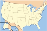
. It is located primarily in Ravalli County, Montana
Ravalli County, Montana
-National protected areas:*Bitterroot National Forest *Lee Metcalf National Wildlife Refuge*Lolo National Forest -Demographics:As of the census of 2000 , there were 36,070 people, 14,289 households, and 10,188 families residing in the county. The population density was 15 people per square mile...
(70.26% of the forest), but also has acreage in Idaho County, Idaho
Idaho County, Idaho
Idaho County is a county located in the U.S. state of Idaho. As of the 2010 Census the county had a population of 16,267. The county seat is Grangeville...
(29.24%), and Missoula County, Montana
Missoula County, Montana
-National protected areas:*Bitterroot National Forest *Flathead National Forest *Lolo National Forest *Rattlesnake National Recreation Area-Demographics:...
(0.49%).
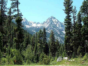
Founded in 1898, the forest is located in the Bitterroot
Bitterroot Range
The Bitterroot Range runs along the border of Montana and Idaho in the northwestern United States. The range spans an area of 62,736 square kilometers and is named after the bitterroot , a small pink flower that is the state flower of Montana.- History :In 1805, the Corps of Discovery,...
and the Sapphire mountain ranges with elevation
Elevation
The elevation of a geographic location is its height above a fixed reference point, most commonly a reference geoid, a mathematical model of the Earth's sea level as an equipotential gravitational surface ....
s ranging from 2,200 feet (650 m) along the Salmon River
Salmon River (Idaho)
The Salmon River is located in Idaho in the northwestern United States. The Salmon is also known as The River of No Return. It flows for through central Idaho, draining and dropping more than between its headwaters, near Galena Summit above the Sawtooth Valley in the Sawtooth National...
in Idaho to 10,157 foot (3,100 m) Trapper Peak. Roughly half the forest (743,000 acres, 3,000 km²) make up part or all of three distinct Wilderness
Wilderness
Wilderness or wildland is a natural environment on Earth that has not been significantly modified by human activity. It may also be defined as: "The most intact, undisturbed wild natural areas left on our planet—those last truly wild places that humans do not control and have not developed with...
areas. These areas include the Anaconda-Pintler
Anaconda-Pintler Wilderness
The Anaconda-Pintler Wilderness is located in southwestern Montana, in the northwestern United States. It runs for 40 miles along both sides of the crest of the Anaconda Range, covering almost 250 square miles . To the north are the Sapphire Mountains, and to the south is the Big Hole Valley...
, Selway-Bitterroot
Selway-Bitterroot Wilderness
The Selway-Bitterroot Wilderness is a protected wilderness area in the states of Idaho and Montana, in the northwestern United States.At 1.3 million acres , it is one of the largest designated wilderness areas in the United States . It spans the Bitterroot Mountain Range, on the border between...
and Frank Church River of No Return Wildernesses. The distinction is that in wilderness areas, no road
Road
A road is a thoroughfare, route, or way on land between two places, which typically has been paved or otherwise improved to allow travel by some conveyance, including a horse, cart, or motor vehicle. Roads consist of one, or sometimes two, roadways each with one or more lanes and also any...
s, logging
Forestry
Forestry is the interdisciplinary profession embracing the science, art, and craft of creating, managing, using, and conserving forests and associated resources in a sustainable manner to meet desired goals, needs, and values for human benefit. Forestry is practiced in plantations and natural stands...
, mining
Mining
Mining is the extraction of valuable minerals or other geological materials from the earth, from an ore body, vein or seam. The term also includes the removal of soil. Materials recovered by mining include base metals, precious metals, iron, uranium, coal, diamonds, limestone, oil shale, rock...
or other construction
Construction
In the fields of architecture and civil engineering, construction is a process that consists of the building or assembling of infrastructure. Far from being a single activity, large scale construction is a feat of human multitasking...
is permitted and all access must be done either on foot or horseback; even bicycles are not permitted. Hunting
Hunting
Hunting is the practice of pursuing any living thing, usually wildlife, for food, recreation, or trade. In present-day use, the term refers to lawful hunting, as distinguished from poaching, which is the killing, trapping or capture of the hunted species contrary to applicable law...
however is allowed forest-wide including wilderness areas.
History
The Lewis and Clark ExpeditionLewis and Clark Expedition
The Lewis and Clark Expedition, or ″Corps of Discovery Expedition" was the first transcontinental expedition to the Pacific Coast by the United States. Commissioned by President Thomas Jefferson and led by two Virginia-born veterans of Indian wars in the Ohio Valley, Meriwether Lewis and William...
passed through parts of what are now forest lands in 1805. After the discovery of gold
Gold
Gold is a chemical element with the symbol Au and an atomic number of 79. Gold is a dense, soft, shiny, malleable and ductile metal. Pure gold has a bright yellow color and luster traditionally considered attractive, which it maintains without oxidizing in air or water. Chemically, gold is a...
in Idaho and then Montana in the 1860s, numerous mining towns were built, some of which today are ghost town
Ghost town
A ghost town is an abandoned town or city. A town often becomes a ghost town because the economic activity that supported it has failed, or due to natural or human-caused disasters such as floods, government actions, uncontrolled lawlessness, war, or nuclear disasters...
s. The Nez Perce National Historic Trail
Nez Perce National Historic Trail
The Nez Perce National Historical Trail follows the same journey undertaken by a band of the Nez Perce Indian tribe in 1877 during their attempt to flee the U.S. Cavalry. The 1,170 mile trail was created in 1986 as part of the National Trails System Act and is managed by the U.S. Forest Service....
passes through a portion of the forest, following the route of the retreating Nez Perce on their historic path that led from Idaho to north central Montana in 1877. Heavy logging and other resource depletion beginning in the 1880s led conservationist
Conservationist
Conservationists are proponents or advocates of conservation. They advocate for the protection of all the species in an ecosystem with a strong focus on the natural environment...
s to push for the preservation the forest.
The Bitter Root Forest Reserve was established by the General Land Office
General Land Office
The General Land Office was an independent agency of the United States government responsible for public domain lands in the United States. It was created in 1812 to take over functions previously conducted by the United States Department of the Treasury...
on March 1, 1898 with 4147200 acres (16,783.1 km²). It was transferred to the U.S. Forest Service in 1906. On July 1, 1908 the name was changed to Bitterroot National Forest, with lands added from Big Hole National Forest
Big Hole National Forest
Big Hole National Forest was established as the Big Hole Forest Reserve by the U.S. Forest Service in Montana and Idaho on November 5, 1906 with . It became a National Forest on March 4, 1907. On July 1, 1908 Big Hole was divided between Beaverhead, Deerlodge and Bitterroot National Forests and...
and Hell Gate National Forest
Hell Gate National Forest
Hell Gate National Forest was established as the Hell Gate Forest Reserve by the U.S. Forest Service in Montana on October 3, 1905 with . It became a National Forest on March 4, 1907. On July 1, 1908 the entire forest was divided between Beaverhead, Deerlodge, Missoula and Bitterroot National...
. Other lands were transferred from Biterroot to Beaverhead, Clearwater
Clearwater National Forest
Clearwater National Forest is located in North Central Idaho in the northwestern United States. The forest is bounded on the east by the state of Montana, on the north by the Idaho Panhandle National Forest, and on the south and west by the Nez Perce National Forest and Palouse Prairie.]The forest...
, Nez Perce
Nez Perce National Forest
The Nez Perce National Forest is located in Idaho County in central western Idaho in the northwestern United States. The forest is bounded on the east by the state of Montana, on the north by the Palouse region, and on the south and west by the Clearwater National Forest. It has a total area of...
and Salmon National Forests. On October 29, 1934 part of Selway National Forest
Selway National Forest
Selway National Forest was established by the U.S. Forest Service in Idaho on July 1, 1911 with from parts of Clearwater National Forest and Nez Perce National Forest. On October 29, 1934 the entire forest was divided between Bitterroot, Clearwater, Lolo and Nez Perce, and the name was discontinued...
was added.
Composition
The forest is a combination of both grasslandGrassland
Grasslands are areas where the vegetation is dominated by grasses and other herbaceous plants . However, sedge and rush families can also be found. Grasslands occur naturally on all continents except Antarctica...
s and forested zones. Grazing rights
Grazing rights
Grazing rights is a legal term referring to the right of a user to allow their livestock to feed in a given area.- United States :...
are leased to private landowners in the lower altitude
Altitude
Altitude or height is defined based on the context in which it is used . As a general definition, altitude is a distance measurement, usually in the vertical or "up" direction, between a reference datum and a point or object. The reference datum also often varies according to the context...
s where grasses and shrublands are dominant. Higher up, Douglas fir, larch
Larch
Larches are conifers in the genus Larix, in the family Pinaceae. Growing from 15 to 50m tall, they are native to much of the cooler temperate northern hemisphere, on lowlands in the north and high on mountains further south...
, and lodgepole pine
Lodgepole Pine
Lodgepole Pine, Pinus contorta, also known as Shore Pine, is a common tree in western North America. Like all pines, it is evergreen.-Subspecies:...
slowly give way to Engelmann Spruce
Engelmann Spruce
Picea engelmannii is a species of spruce native to western North America, from central British Columbia and southwest Alberta, southwest to northern California and southeast to Arizona and New Mexico; there are also two isolated populations in northern Mexico...
and whitebark pine
Whitebark Pine
Pinus albicaulis, known commonly as Whitebark Pine, Pitch Pine, Scrub Pine, and Creeping Pine occurs in the mountains of the Western United States and Canada, specifically the subalpine areas of the Sierra Nevada, the Cascade Range, the Pacific Coast Ranges, and the northern Rocky Mountains –...
as the altitude increases. Above the treeline at 8,000 feet (2,400 m) the trees abruptly end and alpine flowers and grasses are found. A small grizzly
Grizzly
Grizzly may refer to:* Grizzly bear , a North American bear* Grizzly , a Marvel Comics character* Grizzly , a novel in Gary Paulsen's World of Adventure series...
bear population is located in the wilderness zones of the forest with black bear
American black bear
The American black bear is a medium-sized bear native to North America. It is the continent's smallest and most common bear species. Black bears are omnivores, with their diets varying greatly depending on season and location. They typically live in largely forested areas, but do leave forests in...
, mountain goat
Mountain goat
The Mountain Goat , also known as the Rocky Mountain Goat, is a large-hoofed mammal found only in North America. Despite its vernacular name, it is not a member of Capra, the genus of true goats...
, bighorn sheep
Bighorn Sheep
The bighorn sheep is a species of sheep in North America named for its large horns. These horns can weigh up to , while the sheep themselves weigh up to . Recent genetic testing indicates that there are three distinct subspecies of Ovis canadensis, one of which is endangered: Ovis canadensis sierrae...
, elk
Elk
The Elk is the large deer, also called Cervus canadensis or wapiti, of North America and eastern Asia.Elk may also refer to:Other antlered mammals:...
and moose
Moose
The moose or Eurasian elk is the largest extant species in the deer family. Moose are distinguished by the palmate antlers of the males; other members of the family have antlers with a dendritic configuration...
found forestwide. An active effort to reintroduce the grizzly bear to the region concluded in 2000 with a plan to release 25 bears into the wilderness zones over a five year period beginning in 2003.
There are 1,600 mi (2,500 km) of trails and 18 improved campgrounds within the forest. Outstanding fishing is found in the dozens of rivers and streams and lakes. The forest headquarters is located in Hamilton, Montana
Hamilton, Montana
Hamilton is a city in and the county seat of Ravalli County, Montana, United States. The population was 3,705 at the 2000 census. Significant outlying population growth is shown in the area; the ZIP Code Tabulation Area for Hamilton's ZIP Code, 59840, had a population of 12,327at the 2000 census.-...
. There are local ranger
National Park Ranger
National Park Service Rangers are among the uniformed employees charged with protecting and preserving areas set aside in the National Park System by the United States Congress and/or the President of the United States...
district offices in Darby
Darby, Montana
Darby is a town in Ravalli County, Montana, United States. The population was 710 at the 2000 census. Darby is located near the southwestern border of Montana and Idaho, along the Continental Divide...
, Stevensville
Stevensville, Montana
Stevensville is a town in Ravalli County, Montana, United States. The population was 1,553 at the 2000 census.-History:Stevensville is officially recognized as the first permanent settlement in the state of Montana...
, and Sula. The largest nearby city is Missoula, Montana
Missoula, Montana
Missoula is a city located in western Montana and is the county seat of Missoula County. The 2010 Census put the population of Missoula at 66,788 and the population of Missoula County at 109,299. Missoula is the principal city of the Missoula Metropolitan Area...
. The scenic Blodgett Canyon
Blodgett Canyon
Blodgett Canyon is located in southwestern Montana in the northwestern United States. It is one of more than two dozen scenic canyons deeply carved into the eastern flanks of the Bitterroot Range in Bitterroot National Forest. Starting from a group of peaks at over 8500 feet along the...
is but one of many steep canyons located in the forest. U.S. Highway
93 passes through portions of the forest.
Bitterroot controversy
Swanson (2011) examines the critical role of Guy M. Brandborg of the U.S. Forest Service, who was supervisor of the Bitterroot National Forest from 1935 to 1955. By insisting on selective cutting, his tried to protect the watersheds and wildlife habitats that are harmed by clear-cutting. After he retired in 1955 Brandborg denounced the Forest Service for deviating from his model of sustainable forestry. He launched a public attack, known as the "Bitterroot controversy." Brandborg lobbied to secure passage of the National Forest Management Act of 1976, that codified his ideals.Further reading
- Swanson, Frederick H. The Bitterroot and Mr. Brandborg: Clearcutting and the Struggle for Sustainable Forestry in the Northern Rockies ( University of Utah Press, 2011). ISBN 978-1-60781-101-5
See also
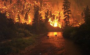
- 2000–2001 fires in the Western United States
- Bitterroot MountainsBitterroot MountainsThe Northern and Central Bitterroot Range, collectively the Bitterroot Mountains, is the largest portion of the Bitterroot Range, part of the Rocky Mountains, located in the panhandle of Idaho and westernmost Montana in the Western United States...
- List of Forests in Montana
External links
- Bitterroot National Forest - U.S. Forest Service
- USGS Gird Point (MT) Topo Map - TopoQuest.com
- Bitterroot National Forest Recreation