

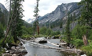
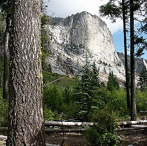
Blodgett Canyon
Encyclopedia
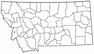
Montana
Montana is a state in the Western United States. The western third of Montana contains numerous mountain ranges. Smaller, "island ranges" are found in the central third of the state, for a total of 77 named ranges of the Rocky Mountains. This geographical fact is reflected in the state's name,...
in the northwestern United States
United States
The United States of America is a federal constitutional republic comprising fifty states and a federal district...
. It is one of more than two dozen scenic canyons deeply carved into the eastern flanks of the Bitterroot Range
Bitterroot Range
The Bitterroot Range runs along the border of Montana and Idaho in the northwestern United States. The range spans an area of 62,736 square kilometers and is named after the bitterroot , a small pink flower that is the state flower of Montana.- History :In 1805, the Corps of Discovery,...
in Bitterroot National Forest
Bitterroot National Forest
Bitterroot National Forest comprises 1.587 million acres in west-central Montana and eastern Idaho, of the United States. It is located primarily in Ravalli County, Montana , but also has acreage in Idaho County, Idaho , and Missoula County, Montana .Founded in 1898, the forest is located in the...
. Starting from a group of peaks at over 8500 feet (2590 m) along the Idaho/Montana border, the canyon steeply drops to Blodgett Lake at 6800 feet (2070 m). After running northeast for about a mile, it turns due east and descends for a total of about 12 miles (19 km) to the Bitterroot Valley
Bitterroot Valley
The Bitterroot Valley is located in southwestern Montana in the northwestern United States. It extends over 100 miles from remote Horse Creek Pass north to a point near the city of Missoula...
. A trailhead is located at the mouth of the canyon, just west of the community of Hamilton
Hamilton, Montana
Hamilton is a city in and the county seat of Ravalli County, Montana, United States. The population was 3,705 at the 2000 census. Significant outlying population growth is shown in the area; the ZIP Code Tabulation Area for Hamilton's ZIP Code, 59840, had a population of 12,327at the 2000 census.-...
and at an elevation of 4000 feet (m).
Selway-Bitterroot Wilderness
The Selway-Bitterroot Wilderness is a protected wilderness area in the states of Idaho and Montana, in the northwestern United States.At 1.3 million acres , it is one of the largest designated wilderness areas in the United States . It spans the Bitterroot Mountain Range, on the border between...
.
In the year 2000, the forest in the lower section of Blodgett Canyon was extensively burned. This damage extends about 2 miles (3 km) above the trailhead.
Geology
The canyons in this region were carved out by ice ageIce age
An ice age or, more precisely, glacial age, is a generic geological period of long-term reduction in the temperature of the Earth's surface and atmosphere, resulting in the presence or expansion of continental ice sheets, polar ice sheets and alpine glaciers...
glacier
Glacier
A glacier is a large persistent body of ice that forms where the accumulation of snow exceeds its ablation over many years, often centuries. At least 0.1 km² in area and 50 m thick, but often much larger, a glacier slowly deforms and flows due to stresses induced by its weight...
s, which left behind U-shaped valley
U-shaped valley
A U-shaped valley also known as a glacial trough is one formed by the process of glaciation. It has a characteristic U-shape, with steep, straight sides, and a flat bottom. Glaciated valleys are formed when a glacier travels across and down a slope, carving the valley by the action of scouring...
s, moraine
Moraine
A moraine is any glacially formed accumulation of unconsolidated glacial debris which can occur in currently glaciated and formerly glaciated regions, such as those areas acted upon by a past glacial maximum. This debris may have been plucked off a valley floor as a glacier advanced or it may have...
s, hanging valleys, and steeply carved granite mountains, cliffs, and cirques
Cirque (landform)
thumb|250 px|Two cirques with semi-permanent snowpatches in [[Abisko National Park]], [[Sweden]].A cirque or corrie is an amphitheatre-like valley head, formed at the head of a valley glacier by erosion...
, all of which are visible within Blodgett Canyon. The glacial valley is carved into granitic
Granite
Granite is a common and widely occurring type of intrusive, felsic, igneous rock. Granite usually has a medium- to coarse-grained texture. Occasionally some individual crystals are larger than the groundmass, in which case the texture is known as porphyritic. A granitic rock with a porphyritic...
rocks of the Bitterroot Lobe of the Idaho Batholith, a Late Cretaceous
Late Cretaceous
The Late Cretaceous is the younger of two epochs into which the Cretaceous period is divided in the geologic timescale. Rock strata from this epoch form the Upper Cretaceous series...
to Paleocene
Paleocene
The Paleocene or Palaeocene, the "early recent", is a geologic epoch that lasted from about . It is the first epoch of the Palaeogene Period in the modern Cenozoic Era...
intrusive body emplaced by subduction
Subduction
In geology, subduction is the process that takes place at convergent boundaries by which one tectonic plate moves under another tectonic plate, sinking into the Earth's mantle, as the plates converge. These 3D regions of mantle downwellings are known as "Subduction Zones"...
beneath the western margin of North America.