

List of Forests in Montana
Encyclopedia
State forest
A state forest is a forest that is administered or protected by some agency of a sovereign state.The precise application of the term varies by jurisdiction...
s in Montana
Montana
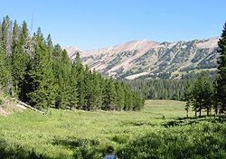
Montana is a state in the Western United States. The western third of Montana contains numerous mountain ranges. Smaller, "island ranges" are found in the central third of the state, for a total of 77 named ranges of the Rocky Mountains. This geographical fact is reflected in the state's name,...
. In addition to currently named forests, there are at least 22 former named forests that have been consolidated into current forest lands.
National Forests are administered by the United States Forest Service
United States Forest Service
The United States Forest Service is an agency of the United States Department of Agriculture that administers the nation's 155 national forests and 20 national grasslands, which encompass...
, an agency of the United States Department of Agriculture
United States Department of Agriculture
The United States Department of Agriculture is the United States federal executive department responsible for developing and executing U.S. federal government policy on farming, agriculture, and food...
. Montana State Forests are administered by the Montana Department of Natural Resources and Conservation.
State forests
- Clearwater State Forest, Missoula County, MontanaMissoula County, Montana-National protected areas:*Bitterroot National Forest *Flathead National Forest *Lolo National Forest *Rattlesnake National Recreation Area-Demographics:...
, 46°55′59"N 113°24′27"W, el. 3802 feet (1,158.8 m) - Coal Creek State Forest, Flathead County, MontanaFlathead County, Montana-National protected areas:* Pacific Northwest National Scenic Trail * Flathead National Forest * Glacier National Park * Kootenai National Forest * Lolo National Forest * Lost Trail National Wildlife Refuge-Demographics:...
, 48°41′37"N 114°17′32"W, el. 4357 feet (1,328 m) - Lincoln State Forest, Lewis and Clark County, MontanaLewis and Clark County, Montana-National protected areas:* Flathead National Forest * Helena National Forest * Lewis and Clark National Forest * Lolo National Forest * Rocky Mountain Front Conservation Area -Demographics:...
, 46°56′00"N 112°41′23"W, el. 4544 feet (1,385 m) - Lubrecht State Experimental Forest, Missoula County, MontanaMissoula County, Montana-National protected areas:*Bitterroot National Forest *Flathead National Forest *Lolo National Forest *Rattlesnake National Recreation Area-Demographics:...
, 46°53′30"N 113°26′03"W, el. 4157 feet (1,267.1 m) - Stillwater State Forest, Flathead County, MontanaFlathead County, Montana-National protected areas:* Pacific Northwest National Scenic Trail * Flathead National Forest * Glacier National Park * Kootenai National Forest * Lolo National Forest * Lost Trail National Wildlife Refuge-Demographics:...
, 48°40′16"N 114°34′57"W, el. 4544 feet (1,385 m) - Sula State Forest, Ravalli County, MontanaRavalli County, Montana-National protected areas:*Bitterroot National Forest *Lee Metcalf National Wildlife Refuge*Lolo National Forest -Demographics:As of the census of 2000 , there were 36,070 people, 14,289 households, and 10,188 families residing in the county. The population density was 15 people per square mile...
, 45°57′00"N 113°57′33"W, el. 5321 feet (1,621.8 m) - Swan River State Forest, Lake County, MontanaLake County, Montana-National protected areas:*Flathead National Forest *National Bison Range *Ninepipe National Wildlife Refuge*Pablo National Wildlife Refuge*Swan River National Wildlife Refuge-Demographics:...
, 47°46′08"N 113°53′34"W, el. 4475 feet (1,364 m) - Thompson River State Forest, Sanders County, MontanaSanders County, MontanaSanders County is a county located in the U.S. state of Montana. As of 2010, the population was 11,413. Its county seat is Thompson Falls.-Geography:According to the U.S...
, 47°41′56"N 114°58′29"W, el. 3399 feet (1,036 m)
National forests
- Beaverhead National Forest, Beaverhead County, MontanaBeaverhead County, Montana-National protected areas:* Beaverhead National Forest * Big Hole National Battlefield* Nez Perce National Historical Park * Red Rock Lakes National Wildlife Refuge-History:...
, 45°30′01"N 113°00′04"W, el. 8812 feet (2,685.9 m) - Bitterroot National ForestBitterroot National ForestBitterroot National Forest comprises 1.587 million acres in west-central Montana and eastern Idaho, of the United States. It is located primarily in Ravalli County, Montana , but also has acreage in Idaho County, Idaho , and Missoula County, Montana .Founded in 1898, the forest is located in the...
, Ravalli County, MontanaRavalli County, Montana-National protected areas:*Bitterroot National Forest *Lee Metcalf National Wildlife Refuge*Lolo National Forest -Demographics:As of the census of 2000 , there were 36,070 people, 14,289 households, and 10,188 families residing in the county. The population density was 15 people per square mile...
, 45°55′00"N 114°17′03"W, el. 5853 feet (1,784 m) - Custer National ForestCuster National ForestCuster National Forest is located primarily in the southern part of the U.S. state of Montana but also has separate sections in northwestern South Dakota. With a total area of 1,278,279 acres , the forest comprises over 10 separate sections...
, Powder River County, MontanaPowder River County, Montana-Demographics:As of the census of 2000, there were 1,858 people, 737 households, and 524 families residing in the county. The population density was -Demographics:...
, 45°30′01"N 106°00′03"W, el. 3622 feet (1,104 m) - Deerlodge National Forest, Jefferson County, MontanaJefferson County, Montana-National protected areas:*Deerlodge National Forest *Helena National Forest -Demographics:As of the census of 2000, there were 10,049 people, 3,747 households, and 2,847 families residing in the county. The population density was 6 people per square mile . There were 4,199 housing units at an...
, 46°05′00"N 112°20′03"W, el. 7424 feet (2,262.8 m) - Flathead National ForestFlathead National ForestThe Flathead National Forest is a national forest in the western part of the U.S. state of Montana. The forest covers of which about 1 million acres is designated wilderness. It is named after the Flathead Indians who lived in the area. The forest is located in the Rocky Mountains with elevations...
, Flathead County, MontanaFlathead County, Montana-National protected areas:* Pacific Northwest National Scenic Trail * Flathead National Forest * Glacier National Park * Kootenai National Forest * Lolo National Forest * Lost Trail National Wildlife Refuge-Demographics:...
, 47°45′01"N 113°30′04"W, el. 5177 feet (1,577.9 m) - Gallatin National ForestGallatin National ForestFounded in 1899, Gallatin National Forest is located in south central Montana, United States. The forest comprises 2.1 million acres and has portions of both the Absaroka-Beartooth and Lee Metcalf Wilderness areas within its boundaries...
, Park County, MontanaPark County, MontanaPark Counties in Montana and Wyoming are among the very few pairs of counties in the United States with the same name to border each other across state lines.-National protected areas:* Custer National Forest * Gallatin National Forest...
, 45°15′01"N 111°00′04"W, el. 8793 feet (2,680.1 m) - Gallatin Petrified Forest, Gallatin County, MontanaGallatin County, Montana-National protected areas:* Gallatin National Forest * Yellowstone National Park -Demographics:As of the census of 2000, there were 67,831 people, 26,323 households, and 16,188 families residing in the county. The population density was 26 people per square mile . There were 29,489 housing units...
, 45°07′10"N 111°06′08"W, el. 8753 feet (2,667.9 m) - Helena National ForestHelena National ForestHelena National Forest is located in west-central Montana, in the United States. Covering 976,000 acres , the forest is broken into several separate sections. The eastern regions are dominated by the Big Belt Mountains, and are the location of the Gates of the Mountains Wilderness, which remains...
, Lewis and Clark County, MontanaLewis and Clark County, Montana-National protected areas:* Flathead National Forest * Helena National Forest * Lewis and Clark National Forest * Lolo National Forest * Rocky Mountain Front Conservation Area -Demographics:...
, 46°33′00"N 112°12′03"W, el. 5059 feet (1,542 m) - Kaniksu National ForestKaniksu National ForestThe Kaniksu National Forest is a U.S. National Forest located in northeastern Washington, the Idaho panhandle, and northwestern Montana. The Idaho portion is one of three forests that are aggregated into the Idaho Panhandle National Forest, along with the Coeur d'Alene National Forest and St. Joe...
, Sanders County, MontanaSanders County, MontanaSanders County is a county located in the U.S. state of Montana. As of 2010, the population was 11,413. Its county seat is Thompson Falls.-Geography:According to the U.S...
, 48°04′00"N 115°48′19"W, el. 2247 feet (684.9 m) - Kootenai National ForestKootenai National ForestKootenai National Forest is located in the far northwestern section of Montana and the northeasternmost lands in the Idaho panhandle, United States along the Canadian border. Of the 2.2 million acres administered by the forest, less than 3 percent is located in the state of Idaho. Forest...
, Lincoln County, MontanaLincoln County, Montana-National protected areas:* Pacific Northwest National Scenic Trail *Flathead National Forest *Kaniksu National Forest *Kootenai National Forest -Demographics:...
, 48°32′30"N 115°25′04"W, el. 4924 feet (1,500.8 m) - Lewis and Clark National ForestLewis and Clark National ForestLewis and Clark National Forest is located in west central Montana, United States. Spanning , the forest is managed as two separate zones. The eastern sections, under the Jefferson Division, is a mixture of grass and shrublands dotted with "island" pockets of forested areas. Here, cattle leases to...
, Meagher County, MontanaMeagher County, Montana-National protected areas:*Gallatin National Forest *Helena National Forest *Lewis and Clark National Forest -Demographics:As of the census of 2000, there were 1,932 people, 803 households, and 529 families residing in the county...
, 46°55′00"N 110°38′03"W, el. 6647 feet (2,026 m) - Lolo National ForestLolo National ForestLolo National Forest is located in western Montana, United States with the western boundary being the state of Idaho. The forest spans 2 million acres and includes four wilderness areas; the Scapegoat and the Bob Marshall Wilderness are partially within the forest while the Welcome Creek and...
, Sanders County, MontanaSanders County, MontanaSanders County is a county located in the U.S. state of Montana. As of 2010, the population was 11,413. Its county seat is Thompson Falls.-Geography:According to the U.S...
, 47°35′00"N 115°35′04"W, el. 5302 feet (1,616 m)
Former national forests
- Absaroka National ForestAbsaroka National ForestAbsaroka National Forest was established by the General Land Office in Montana on September 4, 1902 as the Absaroka Forest Reserve with . On January 29, 1903 it was combined with the Yellowstone Forest Reserve, but it was reinstated as a National Forest under the U.S...
, now part of Lewis and Clark National Forest and Gallatin National Forest (1945) - Beartooth National ForestBeartooth National ForestBeartooth National Forest was established in Montana on July 1, 1908 by the U.S. Forest Service with from part of Yellowstone National Forest and all of Pryor Mountains National Forest...
, now part of Custer National Forest (1932) - Big Belt National ForestBig Belt National ForestBig Belt National Forest was established as the Big Belt Forest Reserve by the U.S. Forest Service in Montana on October 3, 1905 with . It became a National Forest on March 4, 1907. On July 1, 1908 part of Big Belt was combined with Gallatin National Forest and the remainder with Helena National...
, now part of Helena National Forest and Gallatin National Forest (1908) - Big Hole National ForestBig Hole National ForestBig Hole National Forest was established as the Big Hole Forest Reserve by the U.S. Forest Service in Montana and Idaho on November 5, 1906 with . It became a National Forest on March 4, 1907. On July 1, 1908 Big Hole was divided between Beaverhead, Deerlodge and Bitterroot National Forests and...
, now part of Beaverhead, Deerlodge and Bitterroot National Forests (1908) - Blackfeet National ForestBlackfeet National ForestBlackfeet National Forest was established by the U.S. Forest Service in Montana on July 1, 1908 with . On June 22, 1935 Blackfeet was divided between Flathead National Forest and Kootenai National Forest, and the name was discontinued. -External links:*...
, now part of Flathead National Forest and Kootenai National Forest (1935) - Cabinet National ForestCabinet National ForestCabinet National Forest was established in Idaho and Montana by the U.S. Forest Service on March 2, 1907 with , mostly in Montana. On July 1, 1954 it was divided among Kaniksu, Kootenai and Lolo National Forests. -External links:*...
, now part of Kaniksu, Kootenai and Lolo National Forests (1954) - Crazy Mountain National ForestCrazy Mountain National ForestCrazy Mountain National Forest was established as the Crazy Mountain Forest Reserve in Montana by the U.S. Forest Service on August 10, 1906 with . It became a National Forest on March 4, 1907...
, now part of Lewis and Clark National Forest (1908) - Ekalaka National ForestEkalaka National ForestEkalaka National Forest was established as the Ekalaka Forest Reserve in Montana on November 5, 1906 with . It became a National Forest on March 4, 1907...
, now part of Custer National Forest (1908) - Elkhorn National ForestElkhorn National ForestElkhorn National Forest was established as the Elkhorn Forest Reserve in Montana on May 12, 1905 with . It became a National Forest on March 4, 1907. On July 1, 1908 it was combined with Helena National Forest and the name was discontinued....
, now part of Helena National Forest (1908) - Flathead Forest ReserveFlathead Forest ReserveThe Flathead Forest Reserve was established in Montana by the General Land Office on February 22, 1897 with . On June 9, 1903 it was combined with the Lewis and Clarke Forest Reserve and its name was discontinued....
, now part of Flathead National Forest and Lewis and Clark National Forest (1903) - Hell Gate National ForestHell Gate National ForestHell Gate National Forest was established as the Hell Gate Forest Reserve by the U.S. Forest Service in Montana on October 3, 1905 with . It became a National Forest on March 4, 1907. On July 1, 1908 the entire forest was divided between Beaverhead, Deerlodge, Missoula and Bitterroot National...
, now part of Beaverhead, Deerlodge, Missoula and Bitterroot National Forests (1908) - Highwood Mountains National ForestHighwood Mountains National ForestHighwood Mountains National Forest was established as the Highwood Mountains Forest Reserve by the U.S. Forest Service in Montana on April 12, 1906 with . It became a National Forest on March 4, 1907...
, now part of Lewis and Clark National Forest (1908) - Jefferson National Forest (Montana)Jefferson National Forest (Montana)Jefferson National Forest in Montana was established by the U.S. Forest Service on July 1, 1908 with from the consolidation of Little Belt, Highwood Mountains, Snowy Mountains and Little Rockies National Forests. On April 8, 1932 the entire forest was transferred to Lewis and Clark National...
, now part of Lewis and Clark National Forest (1932) - Little Belt National ForestLittle Belt National ForestLittle Belt National Forest was established as the Little Belt Forest Reserve by the U.S. Forest Service in Montana on October 3, 1905 with after a name change from Little Belt Mountains Forest Reserve, which was established on August 16, 1902 with . It became a National Forest on March 4, 1907...
, now part of Lewis and Clark National Forest (1908) - Little Rockies National ForestLittle Rockies National ForestLittle Rockies National Forest was established by the U.S. Forest Service in Montana on March 2, 1907 with . On July 1, 1908 the entire forest was combined with Little Belt, Snowy Mountains and Highwood Mountains National Forests to establish Jefferson National Forest and the name was discontinued...
, now part of Lewis and Clark National Forest (1908) - Long Pine National ForestLong Pine National ForestLong Pine National Forest was established as the Long Pine Forest Reserve in Montana on September 24, 1906 with . It became a National Forest on March 4, 1907...
, now part of Custer National Forest (1908) - Madison National ForestMadison National ForestMadison National Forest was established as the Madison Forest Reserve by the General Land Office in Montana on August 16, 1902 with . After the transfer of federal forests to the U.S. Forest Service in 1905, it became a National Forest on March 4, 1907...
, now part of Beaverhead, Gallatin and Deerlodge National Forests (1931) - Missoula National ForestMissoula National ForestMissoula National Forest was established as the Missoula Forest Reserve by the U.S. Forest Service in Montana on November 6, 1906 with . It became a National Forest on March 4, 1907. On July 1, 1908 Missoula received a portion of Hell Gate National Forest...
, now part of Lolo National Forest and Deerlodge National Forest (1931) - Otter National ForestOtter National ForestOtter National Forest was established by the U.S. Forest Service in Montana on March 2, 1907 with . On July 1, 1908 the name was changed to Custer National Forest....
, now part of Custer National Forest (1908) - Pryor Mountains National ForestPryor Mountains National ForestPryor Mountains National Forest was established as the Pryor Mountains Forest Reserve by the U.S. Forest Service in Montana on November 6, 1906 by the U.S. Forest Service with . It became a National Forest on March 4, 1907. On July 1, 1908 it was combined with part of Yellowstone National Forest...
, now part of Custer National Forest (1908) - Sioux National ForestSioux National ForestSioux National Forest was established in Montana and South Dakota on July 1, 1908 with from the consolidation of Cave Hills, Ekalaka, Long Pine, Short Pine and Slim Buttes National Forests...
, now part of Custer National Forest (1920) - Snowy Mountains National ForestSnowy Mountains National ForestSnowy Mountains National Forest was established as the Snowy Mountains Forest Reserve by the U.S. Forest Service in Montana on November 5, 1906 with . It became a National Forest on March 4, 1907...
, now part of Lewis and Clark National Forest (1908)