
Selway-Bitterroot Wilderness
Encyclopedia
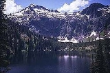
The Selway-Bitterroot Wilderness is a protected wilderness area in the states of Idaho
and Montana
, in the northwestern United States
.
At 1.3 million acres (5,300 km²), it is one of the largest designated wilderness areas in the United States (14th overall, but third-largest outside Alaska). It spans the Bitterroot Mountain Range
, on the border between Idaho and Montana. It covers parts of Bitterroot National Forest
, Clearwater National Forest
, Lolo National Forest
, and the Nez Perce National Forest
. The Frank Church-River of No Return Wilderness Area is immediately to its south, separated only by a dirt road (the Magruder Corridor). Together with adjoining unprotected public land, the two wilderness areas form a five million acre (20,000 km²) wild region.
It is here that the Lochsa
and Selway
rivers form and flow westward to their confluence at Lowell (outside of the wilderness along U.S. Route 12
) to form the Middle Fork of the Clearwater River
. The land ranges in elevation
from 1700 feet (518.2 m) on the Lochsa River to 10157 feet (3,095.9 m) at Trapper Peak
in the Bitterroot Mountains.
One of the largest elk
herds in the United States calls the wilderness home, and it also boasts a healthy population of bighorn sheep
. This wilderness is one of the areas being used to reintroduce wild packs of the grey wolf.
The high-elevation areas around the Bitterroot peaks are rugged alpine parkland. Lower areas are covered by dense coniferous
forest.
Idaho
Idaho is a state in the Rocky Mountain area of the United States. The state's largest city and capital is Boise. Residents are called "Idahoans". Idaho was admitted to the Union on July 3, 1890, as the 43rd state....
and Montana
Montana
Montana is a state in the Western United States. The western third of Montana contains numerous mountain ranges. Smaller, "island ranges" are found in the central third of the state, for a total of 77 named ranges of the Rocky Mountains. This geographical fact is reflected in the state's name,...
, in the northwestern United States
United States
The United States of America is a federal constitutional republic comprising fifty states and a federal district...
.
At 1.3 million acres (5,300 km²), it is one of the largest designated wilderness areas in the United States (14th overall, but third-largest outside Alaska). It spans the Bitterroot Mountain Range
Bitterroot Range
The Bitterroot Range runs along the border of Montana and Idaho in the northwestern United States. The range spans an area of 62,736 square kilometers and is named after the bitterroot , a small pink flower that is the state flower of Montana.- History :In 1805, the Corps of Discovery,...
, on the border between Idaho and Montana. It covers parts of Bitterroot National Forest
Bitterroot National Forest
Bitterroot National Forest comprises 1.587 million acres in west-central Montana and eastern Idaho, of the United States. It is located primarily in Ravalli County, Montana , but also has acreage in Idaho County, Idaho , and Missoula County, Montana .Founded in 1898, the forest is located in the...
, Clearwater National Forest
Clearwater National Forest
Clearwater National Forest is located in North Central Idaho in the northwestern United States. The forest is bounded on the east by the state of Montana, on the north by the Idaho Panhandle National Forest, and on the south and west by the Nez Perce National Forest and Palouse Prairie.]The forest...
, Lolo National Forest
Lolo National Forest
Lolo National Forest is located in western Montana, United States with the western boundary being the state of Idaho. The forest spans 2 million acres and includes four wilderness areas; the Scapegoat and the Bob Marshall Wilderness are partially within the forest while the Welcome Creek and...
, and the Nez Perce National Forest
Nez Perce National Forest
The Nez Perce National Forest is located in Idaho County in central western Idaho in the northwestern United States. The forest is bounded on the east by the state of Montana, on the north by the Palouse region, and on the south and west by the Clearwater National Forest. It has a total area of...
. The Frank Church-River of No Return Wilderness Area is immediately to its south, separated only by a dirt road (the Magruder Corridor). Together with adjoining unprotected public land, the two wilderness areas form a five million acre (20,000 km²) wild region.
It is here that the Lochsa
Lochsa River
The Lochsa River is located in the northwestern United States, in the mountains of north central Idaho. It is one of two primary tributaries of the Middle Fork of the Clearwater River in the Clearwater National Forest. Lochsa is a Nez Perce word meaning rough water.The Lochsa was included by the...
and Selway
Selway River
The Selway River is located in north central Idaho in the northwestern United States within the Selway-Bitterroot Wilderness. It is a tributary of the Middle Fork of the Clearwater River in the Clearwater National Forest...
rivers form and flow westward to their confluence at Lowell (outside of the wilderness along U.S. Route 12
U.S. Route 12 in Idaho
US Route 12 is a state highway in north central Idaho. It extends from the Washington state line in Lewiston east to the Montana state line at Lolo Pass, generally along the route of the Lewis and Clark expedition, and is known as the Northwest Passage Scenic Byway -Route description:US 12 enters...
) to form the Middle Fork of the Clearwater River
Clearwater River (Idaho)
The Clearwater River is a river in north central Idaho, which flows westward from the Bitterroot Mountains along the Idaho-Montana border, and joins the Snake River at Lewiston. In October 1805, the Lewis and Clark Expedition descended the Clearwater River in dugout canoes, putting in at "Canoe...
. The land ranges in elevation
Elevation
The elevation of a geographic location is its height above a fixed reference point, most commonly a reference geoid, a mathematical model of the Earth's sea level as an equipotential gravitational surface ....
from 1700 feet (518.2 m) on the Lochsa River to 10157 feet (3,095.9 m) at Trapper Peak
Trapper Peak (Montana)
Trapper Peak is the highest point in the Bitterroot Mountains, part of the larger Bitterroot Range in western Montana. The peak is located within the Central Bitterroot subrange of the Bitterroot Mountains and the Selway-Bitterroot Wilderness Area. It rises over above the nearby Bitterroot...
in the Bitterroot Mountains.
One of the largest elk
Elk
The Elk is the large deer, also called Cervus canadensis or wapiti, of North America and eastern Asia.Elk may also refer to:Other antlered mammals:...
herds in the United States calls the wilderness home, and it also boasts a healthy population of bighorn sheep
Bighorn Sheep
The bighorn sheep is a species of sheep in North America named for its large horns. These horns can weigh up to , while the sheep themselves weigh up to . Recent genetic testing indicates that there are three distinct subspecies of Ovis canadensis, one of which is endangered: Ovis canadensis sierrae...
. This wilderness is one of the areas being used to reintroduce wild packs of the grey wolf.
The high-elevation areas around the Bitterroot peaks are rugged alpine parkland. Lower areas are covered by dense coniferous
Pinophyta
The conifers, division Pinophyta, also known as division Coniferophyta or Coniferae, are one of 13 or 14 division level taxa within the Kingdom Plantae. Pinophytes are gymnosperms. They are cone-bearing seed plants with vascular tissue; all extant conifers are woody plants, the great majority being...
forest.
See also
- List of largest wilderness areas in the United States
- List of U.S. Wilderness Areas
- Wilderness ActWilderness ActThe Wilderness Act of 1964 was written by Howard Zahniser of The Wilderness Society. It created the legal definition of wilderness in the United States, and protected some 9 million acres of federal land. The result of a long effort to protect federal wilderness, the Wilderness Act was signed...
External links
- Selway-Bitterroot Wilderness Information & Maps
- Selway-Bitterroot Wilderness—Information from the Bitterroot National Forest
- Wilderness.net
- TopoQuest
- National Public Radio report on the Wilderness Act from the Selway-Bitterroot Wilderness]