
Clearwater National Forest
Encyclopedia
Clearwater National Forest is located in North Central Idaho
in the northwestern United States
. The forest
is bounded on the east by the state of Montana
, on the north by the Idaho Panhandle National Forest
, and on the south and west by the Nez Perce National Forest
and Palouse Prairie.
 ]
]
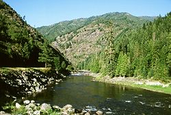
The forest is 1.8 million acres (7,300 km²) and contains mountains and river drainage areas. The Lochsa
and Clearwater River
s flow through the forest region. Portions of the Selway-Bitterroot Wilderness
are also located in the forest. In descending order of land area the forest is located in Idaho
, Clearwater
, and Shoshone
counties. Forest Service headquarters are located in Orofino, Idaho
. There are local ranger
district offices in Kamiah
, Kooskia
, Lolo (Montana)
, Orofino
, and Potlatch
(all in Idaho, except as indicated).
The Clearwater National Forest is home to the well-known Jerry Johnson Hot Springs and the smaller Weir Creek Hot Springs. Both springs are accessible via trails from U.S. Highway 12 and are popular tourist attractions, drawing visitors from Idaho and western Montana.
Lewis and Clark travelled through the region in their journey westward in 1805-1806. Upon reaching Lolo Pass
at the eastern edge of the forest on September 15, 1805, William Clark was quoted as saying,
The Clearwater National Forest was established on July 1, 1908 with 2687860 acres (10,877.4 km²) from parts of Coeur d'Alene National Forest
and Bitterroot National Forest
. On October 29, 1934 part of Selway National Forest
was added.
North Central Idaho
North Central Idaho is an area which spans the central part of the state of Idaho and borders Oregon, Montana, and Washington. It is the southern half of the Idaho Panhandle region and is rich in agriculture and natural resources. Lewis and Clark travelled throughout this area on their journey to...
in the northwestern United States
United States
The United States of America is a federal constitutional republic comprising fifty states and a federal district...
. The forest
Forest
A forest, also referred to as a wood or the woods, is an area with a high density of trees. As with cities, depending where you are in the world, what is considered a forest may vary significantly in size and have various classification according to how and what of the forest is composed...
is bounded on the east by the state of Montana
Montana
Montana is a state in the Western United States. The western third of Montana contains numerous mountain ranges. Smaller, "island ranges" are found in the central third of the state, for a total of 77 named ranges of the Rocky Mountains. This geographical fact is reflected in the state's name,...
, on the north by the Idaho Panhandle National Forest
Idaho Panhandle National Forest
Idaho Panhandle National Forest is a national forest located in the U.S. state of Idaho. Approximately 22.4% of the forest extends into the states of Montana and Washington . The forest was combined in 2000 from three previous separate National Forests which continue to manage themselves somewhat...
, and on the south and west by the Nez Perce National Forest
Nez Perce National Forest
The Nez Perce National Forest is located in Idaho County in central western Idaho in the northwestern United States. The forest is bounded on the east by the state of Montana, on the north by the Palouse region, and on the south and west by the Clearwater National Forest. It has a total area of...
and Palouse Prairie.
The forest is 1.8 million acres (7,300 km²) and contains mountains and river drainage areas. The Lochsa
Lochsa River
The Lochsa River is located in the northwestern United States, in the mountains of north central Idaho. It is one of two primary tributaries of the Middle Fork of the Clearwater River in the Clearwater National Forest. Lochsa is a Nez Perce word meaning rough water.The Lochsa was included by the...
and Clearwater River
Clearwater River (Idaho)
The Clearwater River is a river in north central Idaho, which flows westward from the Bitterroot Mountains along the Idaho-Montana border, and joins the Snake River at Lewiston. In October 1805, the Lewis and Clark Expedition descended the Clearwater River in dugout canoes, putting in at "Canoe...
s flow through the forest region. Portions of the Selway-Bitterroot Wilderness
Selway-Bitterroot Wilderness
The Selway-Bitterroot Wilderness is a protected wilderness area in the states of Idaho and Montana, in the northwestern United States.At 1.3 million acres , it is one of the largest designated wilderness areas in the United States . It spans the Bitterroot Mountain Range, on the border between...
are also located in the forest. In descending order of land area the forest is located in Idaho
Idaho County, Idaho
Idaho County is a county located in the U.S. state of Idaho. As of the 2010 Census the county had a population of 16,267. The county seat is Grangeville...
, Clearwater
Clearwater County, Idaho
Clearwater County is a county located in the U.S. state of Idaho. Established in 1911, the county was named after the Clearwater River. As of the 2000 Census the county had a population of 8,930 . The county seat is Orofino....
, and Shoshone
Shoshone County, Idaho
Shoshone County is a county located in the U.S. state of Idaho. The county was established in 1864, named for the Native American Shoshone tribe. The population was 12,765 at the 2010 census. Shoshone County is commonly referred to as the Silver Valley, due to its century-old mining history...
counties. Forest Service headquarters are located in Orofino, Idaho
Orofino, Idaho
Orofino is a city in Clearwater County, Idaho, along Orofino Creek and the north bank of the Clearwater River. The population was 3,247 at the 2000 census, and the city is the county seat of Clearwater County...
. There are local ranger
National Park Ranger
National Park Service Rangers are among the uniformed employees charged with protecting and preserving areas set aside in the National Park System by the United States Congress and/or the President of the United States...
district offices in Kamiah
Kamiah, Idaho
Kamiah is a city in Idaho and Lewis counties in the U.S. state of Idaho. The largest city in Lewis County, it extends only a small distance into Idaho County. The population was 1,160 at the 2000 census...
, Kooskia
Kooskia, Idaho
Kooskia is a city in Idaho County, Idaho, United States. The population was 675 at the 2000 census.-Geography:Kooskia is located at ....
, Lolo (Montana)
Lolo, Montana
Lolo is a census-designated place in Missoula County, Montana, United States. It is part of the 'Missoula, Montana Metropolitan Statistical Area'. The population was 3,388 at the 2000 census. It is home to Travelers' Rest State Park, a site where Lewis and Clark camped in 1805 and again in 1806...
, Orofino
Orofino, Idaho
Orofino is a city in Clearwater County, Idaho, along Orofino Creek and the north bank of the Clearwater River. The population was 3,247 at the 2000 census, and the city is the county seat of Clearwater County...
, and Potlatch
Potlatch, Idaho
Potlatch is a city in Latah County, Idaho, United States. The population was 791 at the 2000 census.-History:Potlatch was founded in 1905 as a company town by the Potlach Corporation. The townsite was chosen because of proximity to Potlatch Corporation's large holdings of western white pine on the...
(all in Idaho, except as indicated).
The Clearwater National Forest is home to the well-known Jerry Johnson Hot Springs and the smaller Weir Creek Hot Springs. Both springs are accessible via trails from U.S. Highway 12 and are popular tourist attractions, drawing visitors from Idaho and western Montana.
Lewis and Clark travelled through the region in their journey westward in 1805-1806. Upon reaching Lolo Pass
Lolo Pass (Idaho-Montana)
Lolo Pass, elevation , is a mountain pass in the United States, in the Bitterroot Range of the northern Rocky Mountains. It is on the border between the states of Montana and Idaho, approximately west-southwest of Missoula, Montana....
at the eastern edge of the forest on September 15, 1805, William Clark was quoted as saying,
"From this mountain I could observe high rugged mountains in every direction as far as I could see."
The Clearwater National Forest was established on July 1, 1908 with 2687860 acres (10,877.4 km²) from parts of Coeur d'Alene National Forest
Coeur d'Alene National Forest
The Coeur d'Alene is a U.S. National Forest located in the Idaho panhandle and is one of three forests that are aggregated into the Idaho Panhandle National Forest . Coeur d'Alene National Forest is located in Shoshone, Kootenai, and Bonner counties in northern Idaho...
and Bitterroot National Forest
Bitterroot National Forest
Bitterroot National Forest comprises 1.587 million acres in west-central Montana and eastern Idaho, of the United States. It is located primarily in Ravalli County, Montana , but also has acreage in Idaho County, Idaho , and Missoula County, Montana .Founded in 1898, the forest is located in the...
. On October 29, 1934 part of Selway National Forest
Selway National Forest
Selway National Forest was established by the U.S. Forest Service in Idaho on July 1, 1911 with from parts of Clearwater National Forest and Nez Perce National Forest. On October 29, 1934 the entire forest was divided between Bitterroot, Clearwater, Lolo and Nez Perce, and the name was discontinued...
was added.