
.gif)
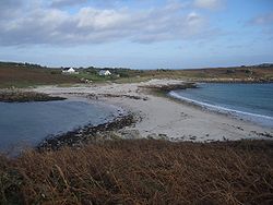
Bar (landform)
Encyclopedia
Linear
In mathematics, a linear map or function f is a function which satisfies the following two properties:* Additivity : f = f + f...
landform
Landform
A landform or physical feature in the earth sciences and geology sub-fields, comprises a geomorphological unit, and is largely defined by its surface form and location in the landscape, as part of the terrain, and as such, is typically an element of topography...
within or extending into a body of water
Water
Water is a chemical substance with the chemical formula H2O. A water molecule contains one oxygen and two hydrogen atoms connected by covalent bonds. Water is a liquid at ambient conditions, but it often co-exists on Earth with its solid state, ice, and gaseous state . Water also exists in a...
, typically composed of sand
Sand
Sand is a naturally occurring granular material composed of finely divided rock and mineral particles.The composition of sand is highly variable, depending on the local rock sources and conditions, but the most common constituent of sand in inland continental settings and non-tropical coastal...
, silt
Silt
Silt is granular material of a size somewhere between sand and clay whose mineral origin is quartz and feldspar. Silt may occur as a soil or as suspended sediment in a surface water body...
or small pebble
Pebble
A pebble is a clast of rock with a particle size of 4 to 64 millimetres based on the Krumbein phi scale of sedimentology. Pebbles are generally considered to be larger than granules and smaller than cobbles . A rock made predominantly of pebbles is termed a conglomerate...
s. A spit
Spit (landform)
A spit or sandspit is a deposition landform found off coasts. At one end, spits connect to land, and extend into the sea. A spit is a type of bar or beach that develops where a re-entrant occurs, such as at cove's headlands, by the process of longshore drift...
or sandspit is a type of shoal. Shoals are characteristically long and narrow (linear) and develop where a stream
Stream
A stream is a body of water with a current, confined within a bed and stream banks. Depending on its locale or certain characteristics, a stream may be referred to as a branch, brook, beck, burn, creek, "crick", gill , kill, lick, rill, river, syke, bayou, rivulet, streamage, wash, run or...
or ocean current
Ocean current
An ocean current is a continuous, directed movement of ocean water generated by the forces acting upon this mean flow, such as breaking waves, wind, Coriolis effect, cabbeling, temperature and salinity differences and tides caused by the gravitational pull of the Moon and the Sun...
promotes deposition of granular material
Granular material
A granular material is a conglomeration of discrete solid, macroscopic particles characterized by a loss of energy whenever the particles interact . The constituents that compose granular material must be large enough such that they are not subject to thermal motion fluctuations...
, resulting in localized shallowing (shoaling) of the water. Shoals can appear in the sea
Sea
A sea generally refers to a large body of salt water, but the term is used in other contexts as well. Most commonly, it means a large expanse of saline water connected with an ocean, and is commonly used as a synonym for ocean...
, in a lake
Lake
A lake is a body of relatively still fresh or salt water of considerable size, localized in a basin, that is surrounded by land. Lakes are inland and not part of the ocean and therefore are distinct from lagoons, and are larger and deeper than ponds. Lakes can be contrasted with rivers or streams,...
, or in a river
River
A river is a natural watercourse, usually freshwater, flowing towards an ocean, a lake, a sea, or another river. In a few cases, a river simply flows into the ground or dries up completely before reaching another body of water. Small rivers may also be called by several other names, including...
. Alternatively a bar may separate a lake from the sea, as in the case of an ayre
Ayre (landform)
An ayre is a name often applied to shingle beaches in Orkney and Shetland. The term is derived from the Old Norse wordfor a shingle beach - "eyrr" - and may be applied to ordinary beaches, to cliff-foot beaches to spits, bars and tombolos, but only if formed of shingle. It is sometimes wrongly...
. They are typically composed of sand
Sand
Sand is a naturally occurring granular material composed of finely divided rock and mineral particles.The composition of sand is highly variable, depending on the local rock sources and conditions, but the most common constituent of sand in inland continental settings and non-tropical coastal...
, although could be of any granular matter that the moving water has access to and is capable of shifting around (for example, soil
Soil
Soil is a natural body consisting of layers of mineral constituents of variable thicknesses, which differ from the parent materials in their morphological, physical, chemical, and mineralogical characteristics...
, silt
Silt
Silt is granular material of a size somewhere between sand and clay whose mineral origin is quartz and feldspar. Silt may occur as a soil or as suspended sediment in a surface water body...
, gravel
Gravel
Gravel is composed of unconsolidated rock fragments that have a general particle size range and include size classes from granule- to boulder-sized fragments. Gravel can be sub-categorized into granule and cobble...
, cobble
Cobble (geology)
A cobble is a clast of rock with a particle size of to based on the Krumbein phi scale of sedimentology. Cobbles are generally considered to be larger than pebbles and smaller than boulders . A rock made predominantly of cobbles is termed a conglomerate....
, shingle
Shingle beach
A shingle beach is a beach which is armoured with pebbles or small- to medium-sized cobbles. Typically, the stone composition may grade from characteristic sizes ranging from two to 200 mm diameter....
, or even boulder
Boulder
In geology, a boulder is a rock with grain size of usually no less than 256 mm diameter. While a boulder may be small enough to move or roll manually, others are extremely massive....
s). The grain size
Particle size (grain size)
Particle size, also called grain size, refers to the diameter of individual grains of sediment, or the lithified particles in clastic rocks. The term may also be applied to other granular materials. This is different from the crystallite size, which is the size of a single crystal inside the...
of the material comprising a bar is related to the size of the waves or the strength of the currents moving the material, but the availability of material to be worked by waves and currents is also important.
The term bar can apply to landform
Landform
A landform or physical feature in the earth sciences and geology sub-fields, comprises a geomorphological unit, and is largely defined by its surface form and location in the landscape, as part of the terrain, and as such, is typically an element of topography...
features spanning a considerable range in size, from a length of a few metres in a small stream to marine depositions stretching for hundreds of kilometres along a coast
Coast
A coastline or seashore is the area where land meets the sea or ocean. A precise line that can be called a coastline cannot be determined due to the dynamic nature of tides. The term "coastal zone" can be used instead, which is a spatial zone where interaction of the sea and land processes occurs...
line, often called barrier islands.
In a nautical sense, a bar is a shoal, similar to a reef
Reef
In nautical terminology, a reef is a rock, sandbar, or other feature lying beneath the surface of the water ....
: a shallow formation of (usually) sand that is a navigation
Navigation
Navigation is the process of monitoring and controlling the movement of a craft or vehicle from one place to another. It is also the term of art used for the specialized knowledge used by navigators to perform navigation tasks...
or grounding
Ship grounding
Ship grounding is a type of marine accident that involves the impact of a ship on the seabed, resulting in damage of the submerged part of her hull and particularly the bottom structure, potentially leading to water ingress and compromise of the ship's structural integrity and stability...
hazard, with a depth of water of six fathom
Fathom
A fathom is a unit of length in the imperial and the U.S. customary systems, used especially for measuring the depth of water.There are 2 yards in an imperial or U.S. fathom...
s or less. It therefore applies to a silt
Silt
Silt is granular material of a size somewhere between sand and clay whose mineral origin is quartz and feldspar. Silt may occur as a soil or as suspended sediment in a surface water body...
accumulation that shallows the entrance to the course of a river
River
A river is a natural watercourse, usually freshwater, flowing towards an ocean, a lake, a sea, or another river. In a few cases, a river simply flows into the ground or dries up completely before reaching another body of water. Small rivers may also be called by several other names, including...
or creek
Stream
A stream is a body of water with a current, confined within a bed and stream banks. Depending on its locale or certain characteristics, a stream may be referred to as a branch, brook, beck, burn, creek, "crick", gill , kill, lick, rill, river, syke, bayou, rivulet, streamage, wash, run or...
.
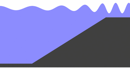
Shoaling
Wave height
In fluid dynamics, the wave height of a surface wave is the difference between the elevations of a crest and a neighbouring trough. Wave height is a term used by mariners, as well as in coastal, ocean and naval engineering....
increases and the distance
Wavelength
In physics, the wavelength of a sinusoidal wave is the spatial period of the wave—the distance over which the wave's shape repeats.It is usually determined by considering the distance between consecutive corresponding points of the same phase, such as crests, troughs, or zero crossings, and is a...
between waves decreases. This behaviour is called shoaling, and the waves are said to shoal. The waves may or may not build to the point where they break
Breaking wave
In fluid dynamics, a breaking wave is a wave whose amplitude reaches a critical level at which some process can suddenly start to occur that causes large amounts of wave energy to be transformed into turbulent kinetic energy...
, depending on how large they were to begin with, and how steep the slope of the beach is. In particular, waves shoal as they pass over submerged sandbanks or reefs. This can be treacherous for boats and ships. It's good for surfers.
Shoaling can also diffract
Diffraction
Diffraction refers to various phenomena which occur when a wave encounters an obstacle. Italian scientist Francesco Maria Grimaldi coined the word "diffraction" and was the first to record accurate observations of the phenomenon in 1665...
waves, so the waves change direction. For example, if waves pass over a sloping sandbank which is shallower at one end than the other, then the shoaling effect will result in the waves slowing more at the shallow end. Thus the wave fronts will refract, changing direction like light passing through a prism. Refraction also occurs as waves move towards a beach if the waves come in at an angle to the beach, or if the beach slopes more gradually at one end than the other.
Sandbars and longshore bars
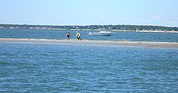
Trough (geology)
In geology, a trough generally refers to a linear structural depression that extends laterally over a distance, while being less steep than a trench.A trough can be a narrow basin or a geologic rift....
) where the waves are breaking, because the breaking waves set up a shoreward current with a compensating counter-current along the bottom. Also known as a trough bar. Sand carried by the offshore moving bottom current is deposited where the current reaches the wave break. Other longshore bars may lie further offshore, representing the break point of even larger waves, or the break point at low tide.
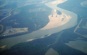
Harbour and river bars
A harbour or river bar is a sedimentary deposit formed at a harbour entrance or river mouth by the deposition of sedimentSediment
Sediment is naturally occurring material that is broken down by processes of weathering and erosion, and is subsequently transported by the action of fluids such as wind, water, or ice, and/or by the force of gravity acting on the particle itself....
or the action of waves on the sea floor or adjacent beaches. A bar can form a dangerous obstacle to shipping, preventing access to the river or harbour in unfavourable weather conditions or at some states of the tide
Tide
Tides are the rise and fall of sea levels caused by the combined effects of the gravitational forces exerted by the moon and the sun and the rotation of the Earth....
.
Where beaches are suitably mobile, or the river’s suspended
Suspended load
Suspended load is the portion of the sediment that is carried by a fluid flow which settle slowly enough such that it almost never touches the bed...
and/or bed
Bed load
The term bed load or bedload describes particles in a flowing fluid that are transported along the bed. Bed load is complementary to suspended load and wash load.Bed load moves by rolling, sliding, and/or saltating ....
loads are large enough, wave action can build up a bar to completely block a river mouth, damming the river, preventing access for boats or shipping, and causing flooding in the lower reaches of the river. This situation will persist until the bar is eroded
Coastal erosion
Coastal erosion is the wearing away of land and the removal of beach or dune sediments by wave action, tidal currents, wave currents, or drainage...
by the sea, or the dammed river develops sufficient head
Hydraulic head
Hydraulic head or piezometric head is a specific measurement of water pressure above a geodetic datum. It is usually measured as a water surface elevation, expressed in units of length, at the entrance of a piezometer...
to break through the bar.
Shoals as geological units

Beach
A beach is a geological landform along the shoreline of an ocean, sea, lake or river. It usually consists of loose particles which are often composed of rock, such as sand, gravel, shingle, pebbles or cobblestones...
, the term shoal can be applied to larger geological units that form off a coastline as part of the process of coastal erosion. These include spit
Spit (landform)
A spit or sandspit is a deposition landform found off coasts. At one end, spits connect to land, and extend into the sea. A spit is a type of bar or beach that develops where a re-entrant occurs, such as at cove's headlands, by the process of longshore drift...
s and baymouth bars that form across the front of embayments and ria
Ria
A ria is a coastal inlet formed by the partial submergence of an unglaciated river valley. It is a drowned river valley that remains open to the sea. Typically, rias have a dendritic, treelike outline although they can be straight and without significant branches. This pattern is inherited from the...
s. A tombolo
Tombolo
A tombolo, from the Italian tombolo, derived from the Latin tumulus, meaning 'mound,' and sometimes translated as ayre , is a deposition landform in which an island is attached to the mainland by a narrow piece of land such as a spit or bar. Once attached, the island is then known as a tied island...
is a bar that forms an isthmus
Isthmus
An isthmus is a narrow strip of land connecting two larger land areas usually with waterforms on either side.Canals are often built through isthmuses where they may be particularly advantageous to create a shortcut for marine transportation...
between an island
Island
An island or isle is any piece of sub-continental land that is surrounded by water. Very small islands such as emergent land features on atolls can be called islets, cays or keys. An island in a river or lake may be called an eyot , or holm...
or offshore rock and a mainland
Mainland
Mainland is a name given to a large landmass in a region , or to the largest of a group of islands in an archipelago. Sometimes its residents are called "Mainlanders"...
shore.
The largest of the geological units of this kind is a barrier island, such as occur along the East Coast of the United States
East Coast of the United States
The East Coast of the United States, also known as the Eastern Seaboard, refers to the easternmost coastal states in the United States, which touch the Atlantic Ocean and stretch up to Canada. The term includes the U.S...
, along the Gulf
Gulf of Mexico
The Gulf of Mexico is a partially landlocked ocean basin largely surrounded by the North American continent and the island of Cuba. It is bounded on the northeast, north and northwest by the Gulf Coast of the United States, on the southwest and south by Mexico, and on the southeast by Cuba. In...
coast, along the southern coast of Belize
Belize
Belize is a constitutional monarchy and the northernmost country in Central America. Belize has a diverse society, comprising many cultures and languages. Even though Kriol and Spanish are spoken among the population, Belize is the only country in Central America where English is the official...
and many other locations worldwide.
In places of re-entrance along a coast
Coast
A coastline or seashore is the area where land meets the sea or ocean. A precise line that can be called a coastline cannot be determined due to the dynamic nature of tides. The term "coastal zone" can be used instead, which is a spatial zone where interaction of the sea and land processes occurs...
line (such as inlet
Inlet
An inlet is a narrow body of water between islands or leading inland from a larger body of water, often leading to an enclosed body of water, such as a sound, bay, lagoon or marsh. In sea coasts an inlet usually refers to the actual connection between a bay and the ocean and is often called an...
s, cove
Cove
A cove is a small type of bay or coastal inlet. They usually have narrow, restricted entrances, are often circular or oval, and are often inside a larger bay. Small, narrow, sheltered bays, inlets, creeks, or recesses in a coast are often considered coves...
s, rias, and bays), sediments carried by a longshore current
Longshore drift
Longshore drift consists of the transportation of sediments along a coast at an angle to the shoreline, which is dependent on prevailing wind direction, swash and backwash. This process occurs in the littoral zone, and in or within close proximity to the surf zone...
will fall out where the current dissipates, forming a spit
Spit (landform)
A spit or sandspit is a deposition landform found off coasts. At one end, spits connect to land, and extend into the sea. A spit is a type of bar or beach that develops where a re-entrant occurs, such as at cove's headlands, by the process of longshore drift...
. An area of water isolated behind a large bar is called a lagoon
Lagoon
A lagoon is a body of shallow sea water or brackish water separated from the sea by some form of barrier. The EU's habitat directive defines lagoons as "expanses of shallow coastal salt water, of varying salinity or water volume, wholly or partially separated from the sea by sand banks or shingle,...
. Over time, lagoons may silt up, becoming salt marsh
Salt marsh
A salt marsh is an environment in the upper coastal intertidal zone between land and salt water or brackish water, it is dominated by dense stands of halophytic plants such as herbs, grasses, or low shrubs. These plants are terrestrial in origin and are essential to the stability of the salt marsh...
es.
In some cases shoals may be precursors to beach expansion and dunes formation, providing a source of windblown sediment to augment such beach or dunes landforms.
Specific geology
The barrier islandBarrier island
Barrier islands, a coastal landform and a type of barrier system, are relatively narrow strips of sand that parallel the mainland coast. They usually occur in chains, consisting of anything from a few islands to more than a dozen...
can be separated into sections for easy study.
Lower shoreface
The shoreface is the part of the barrier where the ocean meets the shore of the island. The barrier island body itself separates the shoreface from the backshore and lagoonLagoon
A lagoon is a body of shallow sea water or brackish water separated from the sea by some form of barrier. The EU's habitat directive defines lagoons as "expanses of shallow coastal salt water, of varying salinity or water volume, wholly or partially separated from the sea by sand banks or shingle,...
/tidal flat area. Characteristics common to the lower shoreface are fine sands with mud and possibly silt. Further out into the ocean the sediment becomes finer. The effect from the waves at this point is weak because of the depth. Bioturbation
Bioturbation
In oceanography, limnology, pedology, geology , and archaeology, bioturbation is the displacement and mixing of sediment particles and solutes by fauna or flora . The mediators of bioturbation are typically annelid worms , bivalves In oceanography, limnology, pedology, geology (especially...
is common and many fossil
Fossil
Fossils are the preserved remains or traces of animals , plants, and other organisms from the remote past...
s can be found here.
Middle shoreface
The middle shore face is located in the upper shoreface. The middle shoreface is strongly influenced by wave action because of its depth. Closer to shore the grain size will be medium size sands with shell pieces common. Since wave action is heavier, bioturbation is not likely.Upper shoreface
The upper shorefaceUpper shoreface
Upper Shoreface refers to the portion of the seafloor that is shallow enough to be agitated by everyday wave action . Below that is lower shoreface.-Overview:...
is constantly effected by wave action. This results in development of herringbone sedimentary structures because of the constant differing flow of waves. Grain size is larger sands.
Foreshore
The foreshore is the area on land between high and low tide. Like the upper shoreface, it is constantly affected by wave action. Cross bedding and lamination are present and coarser sands are present because of the high energy present by the crashing of the waves. The sand is also very well sorted.Backshore
The backshoreBackshore
The backshore area of a beach extending from the limit of high water foam lines to dunes or extreme inland limit of the beach....
is always above the highest water level point. The berm
Berm
A berm is a level space, shelf, or raised barrier separating two areas. Berm originates in the Middle Dutch and German berme and came into usage in English via French.- History :...
is also found here which marks the boundary between the foreshore and backshore. Wind is the important factor here, not water. During strong storms high waves and wind can deliver and erode sediment from the backshore.
Dunes
The duneDune
In physical geography, a dune is a hill of sand built by wind. Dunes occur in different forms and sizes, formed by interaction with the wind. Most kinds of dunes are longer on the windward side where the sand is pushed up the dune and have a shorter "slip face" in the lee of the wind...
s are located at the top of the backshore. The dunes are typical of a barrier island. The high sand dunes are only affected by wind because of their height. Similarly, strong storms are the only thing that really affect the size of the dunes. The dunes will display characteristics of typical eolian wind blown dunes. The difference here is that dunes on a barrier island typically contain vegetation roots and marine bioturbation.
.
Lagoon and tidal flats
The lagoonLagoon
A lagoon is a body of shallow sea water or brackish water separated from the sea by some form of barrier. The EU's habitat directive defines lagoons as "expanses of shallow coastal salt water, of varying salinity or water volume, wholly or partially separated from the sea by sand banks or shingle,...
and tidal flat area is located behind the dune and backshore area. Here the water is still and this allows for fine silts, sands, and mud to settle out. Lagoons can become host to an anaerobic
Hypoxia (environmental)
Hypoxia, or oxygen depletion, is a phenomenon that occurs in aquatic environments as dissolved oxygen becomes reduced in concentration to a point where it becomes detrimental to aquatic organisms living in the system...
environment. This will allow high amounts of organic rich mud to form. Vegetation is also common.
Human habitation
Since prehistoric times humans have chosen some shoals as a site of habitation. In some early cases the locations provided easy access to exploit marine resources. In modern times these sites are sometimes chosen for the water amenity or view, but many such locations are prone to storm damage.See also
- Bank (geography)Bank (geography)A geographic bank has four definitions and applications:# Limnology: The shoreline of a pond, swamp, estuary, reservoir, or lake. The grade can vary from vertical to a shallow slope....
- barrier islandBarrier islandBarrier islands, a coastal landform and a type of barrier system, are relatively narrow strips of sand that parallel the mainland coast. They usually occur in chains, consisting of anything from a few islands to more than a dozen...
- Ocean bank (topography)
- Shingle beachShingle beachA shingle beach is a beach which is armoured with pebbles or small- to medium-sized cobbles. Typically, the stone composition may grade from characteristic sizes ranging from two to 200 mm diameter....
- Tidal islandTidal islandA tidal island is a piece of land that is connected to the mainland by a natural or man-made causeway that is exposed at low tide and submerged at high tide. Because of the mystique surrounding tidal islands many of them have been sites of religious worship, such as Mont Saint Michel with its...
- U.S. Coastal Barrier Resources ActCoastal Barrier Resources ActThe Coastal Barrier Resources Act of the United States was enacted October 18, 1982. The United States Congress passed this Act in order to address the many problems associated with coastal barrier development. CBRA designated various undeveloped coastal barriers, which were illustrated by a...
of 1982