
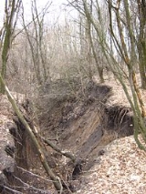
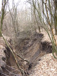
Gully
Encyclopedia
_-_refon_3.jpg)
Landform
A landform or physical feature in the earth sciences and geology sub-fields, comprises a geomorphological unit, and is largely defined by its surface form and location in the landscape, as part of the terrain, and as such, is typically an element of topography...
created by running water
Water
Water is a chemical substance with the chemical formula H2O. A water molecule contains one oxygen and two hydrogen atoms connected by covalent bonds. Water is a liquid at ambient conditions, but it often co-exists on Earth with its solid state, ice, and gaseous state . Water also exists in a...
, eroding
Erosion
Erosion is when materials are removed from the surface and changed into something else. It only works by hydraulic actions and transport of solids in the natural environment, and leads to the deposition of these materials elsewhere...
sharply into soil
Soil
Soil is a natural body consisting of layers of mineral constituents of variable thicknesses, which differ from the parent materials in their morphological, physical, chemical, and mineralogical characteristics...
, typically on a hill
Hill
A hill is a landform that extends above the surrounding terrain. Hills often have a distinct summit, although in areas with scarp/dip topography a hill may refer to a particular section of flat terrain without a massive summit A hill is a landform that extends above the surrounding terrain. Hills...
side. Gullies resemble large ditch
Ditch
A ditch is usually defined as a small to moderate depression created to channel water.In Anglo-Saxon, the word dïc already existed and was pronounced 'deek' in northern England and 'deetch' in the south. The origins of the word lie in digging a trench and forming the upcast soil into a bank...
es or small valley
Valley
In geology, a valley or dale is a depression with predominant extent in one direction. A very deep river valley may be called a canyon or gorge.The terms U-shaped and V-shaped are descriptive terms of geography to characterize the form of valleys...
s, but are metres to tens of metres in depth and width. When the gully formation is in process, the water flow rate
Volumetric flow rate
The volumetric flow rate in fluid dynamics and hydrometry, is the volume of fluid which passes through a given surface per unit time...
can be substantial, which causes the significant deep cutting action into soil.
Gullying or gully erosion is the process by which gullies are formed. Hillsides are more prone to gullying when they are cleared of vegetation, through deforestation
Deforestation
Deforestation is the removal of a forest or stand of trees where the land is thereafter converted to a nonforest use. Examples of deforestation include conversion of forestland to farms, ranches, or urban use....
, over-grazing or other means. The eroded soil
Soil
Soil is a natural body consisting of layers of mineral constituents of variable thicknesses, which differ from the parent materials in their morphological, physical, chemical, and mineralogical characteristics...
is easily carried by the flowing water after being dislodged from the ground, normally when rainfall falls during short, intense storms such as during thunderstorms. Gullies reduce the productivity of farmland where they incise into the land, and produce sediment
Sediment
Sediment is naturally occurring material that is broken down by processes of weathering and erosion, and is subsequently transported by the action of fluids such as wind, water, or ice, and/or by the force of gravity acting on the particle itself....
that may clog downstream waterbodies. Because of this, much effort is invested into the study of gullies within the scope of geomorphology
Geomorphology
Geomorphology is the scientific study of landforms and the processes that shape them...
, in the prevention of gully erosion, and in restoration of gullied landscapes. The total soil loss from gully formation and subsequent downstream river
River
A river is a natural watercourse, usually freshwater, flowing towards an ocean, a lake, a sea, or another river. In a few cases, a river simply flows into the ground or dries up completely before reaching another body of water. Small rivers may also be called by several other names, including...
sedimentation
Sedimentation
Sedimentation is the tendency for particles in suspension to settle out of the fluid in which they are entrained, and come to rest against a barrier. This is due to their motion through the fluid in response to the forces acting on them: these forces can be due to gravity, centrifugal acceleration...
can be sizable.
Hydraulic mining
Artificial gullies are formed during hydraulic miningHydraulic mining
Hydraulic mining, or hydraulicking, is a form of mining that uses high-pressure jets of water to dislodge rock material or move sediment. In the placer mining of gold or tin, the resulting water-sediment slurry is directed through sluice boxes to remove the gold.-Precursor - ground...
when jets or streams of water are projected onto soft alluvial deposits to extract gold
Gold
Gold is a chemical element with the symbol Au and an atomic number of 79. Gold is a dense, soft, shiny, malleable and ductile metal. Pure gold has a bright yellow color and luster traditionally considered attractive, which it maintains without oxidizing in air or water. Chemically, gold is a...
or tin ore. The remains of such mining methods are very visible landform features in old goldfield
Gold mining
Gold mining is the removal of gold from the ground. There are several techniques and processes by which gold may be extracted from the earth.-History:...
s such as in California
California
California is a state located on the West Coast of the United States. It is by far the most populous U.S. state, and the third-largest by land area...
and northern Spain
Spain
Spain , officially the Kingdom of Spain languages]] under the European Charter for Regional or Minority Languages. In each of these, Spain's official name is as follows:;;;;;;), is a country and member state of the European Union located in southwestern Europe on the Iberian Peninsula...
. The badlands at Las Medulas
Las Médulas
Las Médulas is a historical site near the town of Ponferrada in the region of El Bierzo , which used to be the most important gold mine in the Roman Empire...
for example, were created during the Roman period by hushing
Hushing
Hushing is an ancient and historic mining method using a flood or torrent of water to reveal mineral veins. The method was applied in several ways, both in prospecting for ores, and for their exploitation. Mineral veins are often hidden below soil and sub-soil, which must be stripped away to...
or hydraulic mining
Hydraulic mining
Hydraulic mining, or hydraulicking, is a form of mining that uses high-pressure jets of water to dislodge rock material or move sediment. In the placer mining of gold or tin, the resulting water-sediment slurry is directed through sluice boxes to remove the gold.-Precursor - ground...
of the gold-rich alluvium with water supplied by numerous aqueducts tapping nearby rivers. Each aqueduct
Aqueduct
An aqueduct is a water supply or navigable channel constructed to convey water. In modern engineering, the term is used for any system of pipes, ditches, canals, tunnels, and other structures used for this purpose....
produced large gullies below by erosion of the soft deposits. The effluvium was carefully washed with smaller streams of water to extract the nugget
Nugget
Nugget may refer to:* Gold nugget, a piece of gold produced through mining and extraction* Chicken nugget, a lump of breaded or battered chicken* Mosin Nagant, a family of bolt action military rifles* North Bay Nugget, a daily newspaper...
s and gold dust.
Etymology
The earliest usage of the term is from 1657. It originates from the FrenchFrench language
French is a Romance language spoken as a first language in France, the Romandy region in Switzerland, Wallonia and Brussels in Belgium, Monaco, the regions of Quebec and Acadia in Canada, and by various communities elsewhere. Second-language speakers of French are distributed throughout many parts...
word goulet, a diminutive form of goule which means throat. It is possible that the term was derived from a type of knife
Knife
A knife is a cutting tool with an exposed cutting edge or blade, hand-held or otherwise, with or without a handle. Knives were used at least two-and-a-half million years ago, as evidenced by the Oldowan tools...
at the time, a gully-knife, because hills that have gullies look as if they are cut open with a sharp knife.
See also
- Arroyo (creek)Arroyo (creek)An arroyo , a Spanish word translated as brook, and also called a wash is usually a dry creek or stream bed—gulch that temporarily or seasonally fills and flows after sufficient rain. Wadi is a similar term in Africa. In Spain, a rambla has a similar meaning to arroyo.-Types and processes:Arroyos...
- CouleeCouleeCoulee is applied rather loosely to different landforms, all of which refer to a kind of valley or drainage zone.The word coulee comes from the Canadian French coulée, from French word couler meaning "to flow"....
- CouloirCouloirA couloir is a narrow gully with a steep gradient in a mountainous terrain. A couloir may be a seam, scar, or fissure, or vertical crevasse in an otherwise solid mountain mass...
- CanyonCanyonA canyon or gorge is a deep ravine between cliffs often carved from the landscape by a river. Rivers have a natural tendency to reach a baseline elevation, which is the same elevation as the body of water it will eventually drain into. This forms a canyon. Most canyons were formed by a process of...
- GulchGulchA gulch is a deep V-shaped valley formed by erosion. It may contain a small stream or dry creek bed and is usually larger in size than a gully. Occasionally, sudden intense rainfall may produce flash floods in the area of the gulch....
- RavineRavineA ravine is a landform narrower than a canyon and is often the product of streamcutting erosion. Ravines are typically classified as larger in scale than gullies, although smaller than valleys. A ravine is generally a fluvial slope landform of relatively steep sides, on the order of twenty to...
- WadiWadiWadi is the Arabic term traditionally referring to a valley. In some cases, it may refer to a dry riverbed that contains water only during times of heavy rain or simply an intermittent stream.-Variant names:...
- LavakaLavakaLavaka, the Malagasy word for "hole",with steep sides usually on the side of a hill is a type of erosional feature common in Madagascar. They are most abundant in the Central Highlands, where there are deep laterites developed on in steep terrain in a monsoonal climate...
- BadlandsBadlandsA badlands is a type of dry terrain where softer sedimentary rocks and clay-rich soils have been extensively eroded by wind and water. It can resemble malpaís, a terrain of volcanic rock. Canyons, ravines, gullies, hoodoos and other such geological forms are common in badlands. They are often...
- RillRillA Rill can be a:*1.) natural fluvial topographic feature;*2.) functional constructed channel to carry a water supply from a water source some distance away;*3.) aesthetic garden water feature.-Natural:...