

400-series highways
Encyclopedia
The 400-series highways are a network of controlled-access highway
s throughout the southern
portion of the Canadian
province of Ontario
, forming a special subset of the provincial highway system. They are analogous to the Interstate Highway System
in the United States
or the British Motorway network in the United Kingdom
. Modern 400-series highways have high design standards, speed limit
s of 100 kilometres per hour (62.1 mph), and various collision avoidance and traffic management systems. 400-series highway design has set the precedent for a number of innovations used throughout North America
, including the parclo interchange
and the modified Jersey barrier
design known as an Ontario Tall Wall.
The province's baseline standard for the construction of a freeway is an average traffic count of 10,000 vehicles per day. However, other factors are considered as well. To promote economic development in a disadvantaged region (e.g., the current extension of Highway 400 to Northern Ontario
), a 400-series highway may be built where the existing highway's traffic counts fall below 10,000. As well, for environmental, budgetary or community reasons, some proposed 400-series highways (e.g., the Highway 400 extension in Toronto
from Highway 401 to the Gardiner Expressway
that was canceled in the 1970s) have not been built, even where an existing highway's traffic counts exceed the standard.
 For their entire length, 400-series highways are intended to be completely controlled-access and divided, with a minimum of four lanes. Although the 400-series freeways currently form a network around Highway 401 and the Queen Elizabeth Way
(QEW), this has not always been the case (such as Highway 417 until 1999) and being part of a network is not a requirement as it is for Interstate highways. Like the Autoroute system in the neighbouring province of Quebec
, 400-series highways have been expanding slowly because they did not benefit from regular federal funding.
 The province also maintains freeways which are up to 400-series standards, yet are not numbered as part of the 400-series network. This is despite some of those freeways exceeding existing 400-series highways in size and traffic volume and despite some of them being connected to the 400-series network. Nonetheless, Ontario freeways do not receive a 400-series number unless they are designed to be complete controlled-access freeways for their whole length. While at-grade intersections still exist on Highway 406, planning/construction is underway to upgrade them to full freeway standards.
The non-400-series routes listed below have significant open-access portions besides the freeway section, with the freeway segment typically being a small section not at the route's termini. Most prominent is the Conestoga Parkway
in Kitchener-Waterloo, which is numbered in 3 sections; Highway 7/8, Highway 7, and Highway 85, and the Highway 8 Freeport Diversion between Highway 401 and the Conestoga. The E.C. Row Expressway in Windsor
, Ontario
was numbered as part of Highway 2
before the freeway was downloaded to municipal authorities in 1998. Other examples of non-400-series numbered freeways in the provincial inventory are at Thorold
(Highway 58
), Peterborough
to Enterprise Hill (Highway 115
), North Bay
and southward (Highway 11) and Sudbury (Highway 17, though it is possible that the long-term expansion of Highway 417 could incorporate that freeway section of Highway 17).
Although the Queen Elizabeth Way
has no posted highway number, it is considered to be part of the 400-series highway network. In fact, the QEW was the first of the controlled-access highways to be constructed. The Ontario Ministry of Transportation designates the QEW as Highway 451 for internal purposes; this designation never appears on maps or highway signs.
400-series highways receive their numeral designations in one of two ways. The original method was sequential numbering starting at 400 and working up to 409. The first three 400-series highways numbered accordingly were Highway 400, Highway 401 and Highway 402 – originally known as the Barrie
-Toronto
Highway, Highway 2A, and the Blue Water Bridge
Approach respectively. Since then, additional highways have been constructed using sequential numbering from 403 to 409. Although there were plans for a Highway 408, it was never constructed (it is speculated that the new Mid-Peninsula Highway
bypass of the Queen Elizabeth Way
will receive the designation 408). Highway 407 (now 407 ETR) received its designation in the 1960s when it was planned and land was acquired for it, although construction did not begin until 1987.
The later method of 400-series numbering after 1970 was to assign a 400 designation to an upgrade or bypass of an existing highway. For example, the section of Highway 427 between the QEW and Highway 401 was the original routing of Highway 27
between the QEW and Highway 401 before it was upgraded to a freeway, while Highway 427 north of Highway 401 is a bypass of Highway 27. Highway 416 and Highway 417, meanwhile, were the original routings of Highways 16
and 17, respectively, in Eastern Ontario
. In addition, some 400-series highways are given designations based on the existing highways they bypass. For instance, Highway 410 and Highway 420 were both freeway bypasses of Highway 10
and Highway 20
, respectively.

 The majority of 400-series highways are coated with asphalt pavement. All bridge decks are also covered with asphalt, with concrete only exposed around the expansion joints, in contrast to most U.S. Interstates, which have bridge decks paved with exposed concrete containing tining (grooves).
Normally, asphalt pavements would actually require more frequent maintenance because the material is less durable in general. In addition, the laying of additional asphalt layers would require a stronger infrastructure, translating to higher construction costs. However, additional asphalt covers are used on most 400-series highways because the asphalt is more resistant to erosion from de-icing salt than concrete.
Some sections of 400-series highways have been repaved using concrete pavement. Examples include Highway 401 from Windsor to Tilbury, 402 east of Sarnia, 406, 407 ETR, and 427; the 427's concrete pavement has exceeded its 30-year lifespan. Some bridge decks, including the westbound Highway 401 collector lanes that pass over the 401-Don Valley Expressway exit ramp and the westbound Highway 402 overpass at Modeland Road near Sarnia, have also been paved with an exposed concrete highway deck similar to USA interstate standards.
, whose low standard sections are only upgraded when growing traffic conditions warrant a major reconstruction. Although some highways receive a 400-series number right away, they are not built to 400-series standards until construction of the highway is completed.
but is not reinforced and higher at 1070-mm. Full-width left and right paved shoulders are employed on 400-series highways, with rumble strip
s on each side of the carriageway.
Most 400-series highways have design speed of at least 130 km/h, although the posted speed on signs is 100 km/h. Exceptions could be made for sections in urban areas where a 130 km/h design speed cannot be realistically implemented, including Highway 403 through Hamilton (90 km/h), Highway 406 through downtown St. Catharines (80 km/h), and near approaches to border crossings (Highway 401 in Windsor
, 402 in Sarnia
, and 405 in Niagara-on-the-Lake
), which all have a maximum speed of 80 km/h.
Unless there are land space constraints, 4-way junctions should employ parclo interchanges with ramps on the right-hand side where they meet with a surface road in order to help maintain speed on the highways. However, there is no standard for freeway-to-freeway junction as it depends upon traffic volumes, only that there must not be any traffic weaving when merging onto each road (this makes interchanges such as the cloverleaf
not up to 400-series standard).
Acceleration/deceleration lanes from interchanges must be at least 150 metres long to allow for smooth speed increase/decrease and traffic merging, unless there are land space constraints or low traffic volumes. Such exceptions include the Kipling Avenue to Highway 409 directional ramp and the Dundas Street eastbound to Highway 427 southbound directional ramp. The stretch of the QEW through St. Catharines just west of the Garden City Skyway
is well known for lacking acceleration/deceleration lanes, as it was originally built in the 1950s; while it has been grandfathered in with merge signs, a planned reconstruction will bring it up to modern standards. In addition, 400-metre or longer "weave lanes" are required for transitions to/from HOV lanes across the buffer zones to allow for safe mergers.
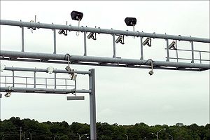
using white-on-blue to distinguish between mainline (express) and collector signage. Toll roads (i.e. 407 ETR) also need to have white-on-blue signage. Advanced warning signage are placed at 2 km, 1 km and 500 m before junctions, and square lane deviation signs (unique to Ontario) notifying drivers approximately 1 km before their lane leaves the highway. Separated high-occupancy vehicle lane
s use black-on-white signage with a diamond logo in the upper left-hand corner.
Most service/attraction signage used on 400-series highways is white-on-blue, though older brown-on-white signs still exist. Caution signage is black-on-yellow, while construction (temporary conditions) signage is black-on-orange.
Roadside advertisements (e.g. billboards) are banned from the right-of-way of 400-series highways. The province has also obtained court orders forcing the removal of advertising signs that are outside of the highway corridor, but adjacent to and still visible from, a 400-series highway (such as along nearby farms close to the freeway). This ban exists to prevent driver distraction. By contrast, the elevated portion of the municipal Gardiner Expressway
has many adjacent signs.
Many 400-series highways have also recently had gates installed at entrance ramps, along with special gated ramps located near overpasses, allowing access to the highway to be easily closed in case of emergency or road work.
Some 400-series highways have bilingual English-French signage (400, 401, 404, 409, 416, 417, 427). The QEW had bilingual sign
s, but they have since been removed.
is being replaced with Ontario Tall Wall
when needed. The use of box-beam guard rails have been replaced in some stretches with Ontario Tall Wall or standard guardrails.
 There are several plans in progress to add new routes to the 400-series highway system to serve the growing population of motorists throughout Ontario
, specifically Southern Ontario
. Some of these new routes may be toll roads owned and operated in a similar fashion to Highway 407. In addition, the long-term extension of Highway 417 towards North Bay (and beyond), as well as construction of a staged freeway on the Highway 11 corridor, would likely absorb the existing freeway sections of Highway 11 and Highway 17 into 400-series highways. Also, a highway to connect the City of Guelph to highway 410 and later 400 is in the planning stages.
, and the National Capital Region
. The first HOV lanes in the Greater Toronto Area (GTA) were introduced to Highway 404 (southbound) from Beaver Creek (between Highway 7 and 16th Avenue) in York Region to Highway 401/Don Valley Parkway
in Toronto
. An exclusive HOV ramp/tunnel from the Highway 404 HOV lane to the Highway 401 westbound collectors was also built at the same time in Toronto
. In addition, HOV lanes were introduced on Highway 403 from Highway 401/Highway 410 to Highway 407 in Mississauga.
In May 2007, the Ministry of Transportation introduced a multi-billion dollar Horseshoe Network Project, which includes plans to incorporate HOV lanes into numerous 400-series highways. On July 23, 2007, an HOV lane was opened on Highway 404 (northbound) from the north of Sheppard Ave to Highway 7, matching the current southbound HOV lane.
More than 450 kilometres of HOV lanes are expected to be implemented in 400-series highways. The general goals of the project is to help increase highway efficiency (an HOV lane is expected to have the ability to move as many people as four general-purpose lanes), reduce congestion, conserve energy and help protect the environment.
Controlled-access highway
A controlled-access highway is a highway designed exclusively for high-speed vehicular traffic, with all traffic flow and ingress/egress regulated...
s throughout the southern
Southern Ontario
Southern Ontario is a region of the province of Ontario, Canada that lies south of the French River and Algonquin Park. Depending on the inclusion of the Parry Sound and Muskoka districts, its surface area would cover between 14 to 15% of the province. It is the southernmost region of...
portion of the Canadian
Canada
Canada is a North American country consisting of ten provinces and three territories. Located in the northern part of the continent, it extends from the Atlantic Ocean in the east to the Pacific Ocean in the west, and northward into the Arctic Ocean...
province of Ontario
Ontario
Ontario is a province of Canada, located in east-central Canada. It is Canada's most populous province and second largest in total area. It is home to the nation's most populous city, Toronto, and the nation's capital, Ottawa....
, forming a special subset of the provincial highway system. They are analogous to the Interstate Highway System
Interstate Highway System
The Dwight D. Eisenhower National System of Interstate and Defense Highways, , is a network of limited-access roads including freeways, highways, and expressways forming part of the National Highway System of the United States of America...
in the United States
United States
The United States of America is a federal constitutional republic comprising fifty states and a federal district...
or the British Motorway network in the United Kingdom
United Kingdom
The United Kingdom of Great Britain and Northern IrelandIn the United Kingdom and Dependencies, other languages have been officially recognised as legitimate autochthonous languages under the European Charter for Regional or Minority Languages...
. Modern 400-series highways have high design standards, speed limit
Speed limit
Road speed limits are used in most countries to regulate the speed of road vehicles. Speed limits may define maximum , minimum or no speed limit and are normally indicated using a traffic sign...
s of 100 kilometres per hour (62.1 mph), and various collision avoidance and traffic management systems. 400-series highway design has set the precedent for a number of innovations used throughout North America
North America
North America is a continent wholly within the Northern Hemisphere and almost wholly within the Western Hemisphere. It is also considered a northern subcontinent of the Americas...
, including the parclo interchange
Parclo interchange
A partial cloverleaf interchange or parclo is a modification of a cloverleaf interchange. The parclo interchange was developed by the Ontario Ministry of Transportation as a replacement for the cloverleaf on 400-Series Highways, removing the dangerous weaving patterns and allowing for more...
and the modified Jersey barrier
Jersey barrier
A Jersey barrier or Jersey wall is a modular concrete barrier employed to separate lanes of traffic. It is designed to both minimize vehicle damage in cases of incidental contact while still preventing crossover in the case of head-on accidents....
design known as an Ontario Tall Wall.
The province's baseline standard for the construction of a freeway is an average traffic count of 10,000 vehicles per day. However, other factors are considered as well. To promote economic development in a disadvantaged region (e.g., the current extension of Highway 400 to Northern Ontario
Northern Ontario
Northern Ontario is a region of the Canadian province of Ontario which lies north of Lake Huron , the French River and Lake Nipissing. The region has a land area of 802,000 km2 and constitutes 87% of the land area of Ontario, although it contains only about 6% of the population...
), a 400-series highway may be built where the existing highway's traffic counts fall below 10,000. As well, for environmental, budgetary or community reasons, some proposed 400-series highways (e.g., the Highway 400 extension in Toronto
Toronto
Toronto is the provincial capital of Ontario and the largest city in Canada. It is located in Southern Ontario on the northwestern shore of Lake Ontario. A relatively modern city, Toronto's history dates back to the late-18th century, when its land was first purchased by the British monarchy from...
from Highway 401 to the Gardiner Expressway
Gardiner Expressway
The Frederick G. Gardiner Expressway, colloquially referred to as "the Gardiner", is a municipal expressway in the Canadian province of Ontario, connecting downtown Toronto with its western suburbs...
that was canceled in the 1970s) have not been built, even where an existing highway's traffic counts exceed the standard.
Network
Queen Elizabeth Way
The Queen Elizabeth Way, commonly abbreviated as the QEW, is a 400-Series highway in the Canadian province of Ontario. The freeway links Buffalo, New York and the Niagara Peninsula with Toronto. It begins at the Peace Bridge in Fort Erie and travels around the western shore of Lake Ontario, ending...
(QEW), this has not always been the case (such as Highway 417 until 1999) and being part of a network is not a requirement as it is for Interstate highways. Like the Autoroute system in the neighbouring province of Quebec
Quebec
Quebec or is a province in east-central Canada. It is the only Canadian province with a predominantly French-speaking population and the only one whose sole official language is French at the provincial level....
, 400-series highways have been expanding slowly because they did not benefit from regular federal funding.
Equivalent provincial highways
The non-400-series routes listed below have significant open-access portions besides the freeway section, with the freeway segment typically being a small section not at the route's termini. Most prominent is the Conestoga Parkway
Conestoga Parkway
The Conestoga Parkway is a freeway in the Regional Municipality of Waterloo, in the Canadian province of Ontario. It runs northeast/southwest through the cities of Kitchener and Waterloo, and is connected to Highway 401 via the Highway 8 Freeport Diversion and King Street East.- Route...
in Kitchener-Waterloo, which is numbered in 3 sections; Highway 7/8, Highway 7, and Highway 85, and the Highway 8 Freeport Diversion between Highway 401 and the Conestoga. The E.C. Row Expressway in Windsor
Windsor, Ontario
Windsor is the southernmost city in Canada and is located in Southwestern Ontario at the western end of the heavily populated Quebec City – Windsor Corridor. It is within Essex County, Ontario, although administratively separated from the county government. Separated by the Detroit River, Windsor...
, Ontario
Ontario
Ontario is a province of Canada, located in east-central Canada. It is Canada's most populous province and second largest in total area. It is home to the nation's most populous city, Toronto, and the nation's capital, Ottawa....
was numbered as part of Highway 2
Highway 2 (Ontario)
King's Highway 2, usually referred to simply as Highway 2 is a provincially maintained highway in Ontario. Once the primary east–west route across the southern end of the province, Highway 2 became mostly redundant in the 1960s following the completion of Highway 401, which more or less...
before the freeway was downloaded to municipal authorities in 1998. Other examples of non-400-series numbered freeways in the provincial inventory are at Thorold
Thorold, Ontario
Thorold is a city in Ontario, Canada, located on the Niagara Escarpment. It is also the seat of the Regional Municipality of Niagara....
(Highway 58
Highway 58 (Ontario)
King's Highway 58, commonly referred to as Highway 58, is a provincially maintained highway in the Canadian province of Ontario. Highway 58 currently runs from the Highway 406 junction on the St. Catharines – Thorold boundary to the Highway 406 junction near Turner's Corners, all...
), Peterborough
Peterborough, Ontario
Peterborough is a city on the Otonabee River in southern Ontario, Canada, 125 kilometres northeast of Toronto. The population of the City of Peterborough was 74,898 as of the 2006 census, while the census metropolitan area has a population of 121,428 as of a 2009 estimate. It presently ranks...
to Enterprise Hill (Highway 115
Highway 115 (Ontario)
King's Highway 115, commonly referred to as Highway 115 is a provincially maintained highway in the Canadian province of Ontario that connects Peterborough with Toronto via Highway 401...
), North Bay
North Bay, Ontario
North Bay is a city in Northeastern Ontario, Canada. It is the seat of Nipissing District, and takes its name from its position on the shore of Lake Nipissing.-History:...
and southward (Highway 11) and Sudbury (Highway 17, though it is possible that the long-term expansion of Highway 417 could incorporate that freeway section of Highway 17).
Numbering
The "400-series" numbers were first introduced in 1952 to designate the province's controlled-access highways.Although the Queen Elizabeth Way
Queen Elizabeth Way
The Queen Elizabeth Way, commonly abbreviated as the QEW, is a 400-Series highway in the Canadian province of Ontario. The freeway links Buffalo, New York and the Niagara Peninsula with Toronto. It begins at the Peace Bridge in Fort Erie and travels around the western shore of Lake Ontario, ending...
has no posted highway number, it is considered to be part of the 400-series highway network. In fact, the QEW was the first of the controlled-access highways to be constructed. The Ontario Ministry of Transportation designates the QEW as Highway 451 for internal purposes; this designation never appears on maps or highway signs.
400-series highways receive their numeral designations in one of two ways. The original method was sequential numbering starting at 400 and working up to 409. The first three 400-series highways numbered accordingly were Highway 400, Highway 401 and Highway 402 – originally known as the Barrie
Barrie, Ontario
Barrie is a city in Southern Ontario, Canada, located on the western shore of Lake Simcoe, approximately 90 km north of Toronto. Although located in Simcoe County, the city is politically independent...
-Toronto
Toronto
Toronto is the provincial capital of Ontario and the largest city in Canada. It is located in Southern Ontario on the northwestern shore of Lake Ontario. A relatively modern city, Toronto's history dates back to the late-18th century, when its land was first purchased by the British monarchy from...
Highway, Highway 2A, and the Blue Water Bridge
Blue Water Bridge
The Blue Water Bridge is a twin-span international bridge across the St. Clair River that links Port Huron, Michigan, USA and Sarnia, Ontario, Canada...
Approach respectively. Since then, additional highways have been constructed using sequential numbering from 403 to 409. Although there were plans for a Highway 408, it was never constructed (it is speculated that the new Mid-Peninsula Highway
Mid-Peninsula Highway
The Mid-Peninsula Highway is a proposed freeway across the Niagara Peninsula in the Canadian province of Ontario. Although plans for a highway connecting Hamilton to Fort Erie south of the Niagara Escarpment have surfaced for decades,...
bypass of the Queen Elizabeth Way
Queen Elizabeth Way
The Queen Elizabeth Way, commonly abbreviated as the QEW, is a 400-Series highway in the Canadian province of Ontario. The freeway links Buffalo, New York and the Niagara Peninsula with Toronto. It begins at the Peace Bridge in Fort Erie and travels around the western shore of Lake Ontario, ending...
will receive the designation 408). Highway 407 (now 407 ETR) received its designation in the 1960s when it was planned and land was acquired for it, although construction did not begin until 1987.
The later method of 400-series numbering after 1970 was to assign a 400 designation to an upgrade or bypass of an existing highway. For example, the section of Highway 427 between the QEW and Highway 401 was the original routing of Highway 27
Highway 27 (Ontario)
Highway 27, formerly known as King's Highway 27, was a provincially maintained highway in southern Ontario that is now cared for by the city of Toronto, York Region and Simcoe County. It is considered an undivided expressway in Toronto's municipal expressway network...
between the QEW and Highway 401 before it was upgraded to a freeway, while Highway 427 north of Highway 401 is a bypass of Highway 27. Highway 416 and Highway 417, meanwhile, were the original routings of Highways 16
Highway 16 (Ontario)
King's Highway 16, commonly known as Highway 16 and historically as the Prescott Highway, is a provincially maintained highway in the Canadian province of Ontario. The highway once travelled from near Prescott to Ottawa. However, its length was truncated significantly when most of the route was...
and 17, respectively, in Eastern Ontario
Eastern Ontario
Eastern Ontario is a subregion of Southern Ontario in the Canadian province of Ontario which lies in a wedge-shaped area between the Ottawa River and St. Lawrence River...
. In addition, some 400-series highways are given designations based on the existing highways they bypass. For instance, Highway 410 and Highway 420 were both freeway bypasses of Highway 10
Highway 10 (Ontario)
King's Highway 10, commonly referred to as Highway 10 and historically as the Toronto–Sydenham Road, is a provincially maintained highway in the Canadian province of Ontario...
and Highway 20
Highway 20 (Ontario)
King's Highway 20, also known as Highway 20, is a provincially maintained highway in the Canadian province of Ontario. Presently, it is a short stub between Highway 58 and Niagara Regional Road 70 in the town of Thorold.- History :...
, respectively.
Pavement surface
Normally, asphalt pavements would actually require more frequent maintenance because the material is less durable in general. In addition, the laying of additional asphalt layers would require a stronger infrastructure, translating to higher construction costs. However, additional asphalt covers are used on most 400-series highways because the asphalt is more resistant to erosion from de-icing salt than concrete.
Some sections of 400-series highways have been repaved using concrete pavement. Examples include Highway 401 from Windsor to Tilbury, 402 east of Sarnia, 406, 407 ETR, and 427; the 427's concrete pavement has exceeded its 30-year lifespan. Some bridge decks, including the westbound Highway 401 collector lanes that pass over the 401-Don Valley Expressway exit ramp and the westbound Highway 402 overpass at Modeland Road near Sarnia, have also been paved with an exposed concrete highway deck similar to USA interstate standards.
Highway standards
Most 400-series highways follow a list of required construction standards similar to those of many other controlled-access highway systems. However, in some cases, different standards applied at the time of construction and have been grandfathered to the system. This is most prominent on Highway 400, Highway 401, and the Queen Elizabeth WayQueen Elizabeth Way
The Queen Elizabeth Way, commonly abbreviated as the QEW, is a 400-Series highway in the Canadian province of Ontario. The freeway links Buffalo, New York and the Niagara Peninsula with Toronto. It begins at the Peace Bridge in Fort Erie and travels around the western shore of Lake Ontario, ending...
, whose low standard sections are only upgraded when growing traffic conditions warrant a major reconstruction. Although some highways receive a 400-series number right away, they are not built to 400-series standards until construction of the highway is completed.
Roadway
All 400-series highways should have at least two lanes in each direction, with HOV lanes separated from general traffic with a striped buffer zone and full shoulder if necessary. Lanes of opposing directions should always be separated either by a grass median, usually of sufficient width to prevent cross-directional collisions, to provide drainage, and may allow for future expansion, or an "Ontario tall-wall" concrete barrier if a grass median is not feasible (the tall wall is based upon the Jersey barrierJersey barrier
A Jersey barrier or Jersey wall is a modular concrete barrier employed to separate lanes of traffic. It is designed to both minimize vehicle damage in cases of incidental contact while still preventing crossover in the case of head-on accidents....
but is not reinforced and higher at 1070-mm. Full-width left and right paved shoulders are employed on 400-series highways, with rumble strip
Rumble strip
Rumble strips, also known as sleeper lines, are a road safety feature that alert inattentive drivers to potential danger by causing a tactile vibration and audible rumbling, transmitted through the wheels into the car body...
s on each side of the carriageway.
Most 400-series highways have design speed of at least 130 km/h, although the posted speed on signs is 100 km/h. Exceptions could be made for sections in urban areas where a 130 km/h design speed cannot be realistically implemented, including Highway 403 through Hamilton (90 km/h), Highway 406 through downtown St. Catharines (80 km/h), and near approaches to border crossings (Highway 401 in Windsor
Windsor, Ontario
Windsor is the southernmost city in Canada and is located in Southwestern Ontario at the western end of the heavily populated Quebec City – Windsor Corridor. It is within Essex County, Ontario, although administratively separated from the county government. Separated by the Detroit River, Windsor...
, 402 in Sarnia
Sarnia, Ontario
Sarnia is a city in Southern Ontario, Canada . It is the largest city on Lake Huron and is located where the upper Great Lakes empty into the St. Clair River....
, and 405 in Niagara-on-the-Lake
Niagara-on-the-Lake, Ontario
Niagara-on-the-Lake is a Canadian town located in Southern Ontario where the Niagara River meets Lake Ontario in the Niagara Region of the southern part of the province of Ontario. It is located across the Niagara river from Youngstown, New York, USA...
), which all have a maximum speed of 80 km/h.
Unless there are land space constraints, 4-way junctions should employ parclo interchanges with ramps on the right-hand side where they meet with a surface road in order to help maintain speed on the highways. However, there is no standard for freeway-to-freeway junction as it depends upon traffic volumes, only that there must not be any traffic weaving when merging onto each road (this makes interchanges such as the cloverleaf
Cloverleaf interchange
A cloverleaf interchange is a two-level interchange in which left turns, reverse direction in left-driving regions, are handled by ramp roads...
not up to 400-series standard).
Acceleration/deceleration lanes from interchanges must be at least 150 metres long to allow for smooth speed increase/decrease and traffic merging, unless there are land space constraints or low traffic volumes. Such exceptions include the Kipling Avenue to Highway 409 directional ramp and the Dundas Street eastbound to Highway 427 southbound directional ramp. The stretch of the QEW through St. Catharines just west of the Garden City Skyway
Garden City Skyway
The Garden City Skyway is a major high-level bridge located in St. Catharines and Niagara-on-the-Lake, Ontario, Canada, that allows the Queen Elizabeth Way to cross the Welland Canal without the interruption of a lift bridge. Six lanes of traffic are carried across the bridge, which is 2.2km in...
is well known for lacking acceleration/deceleration lanes, as it was originally built in the 1950s; while it has been grandfathered in with merge signs, a planned reconstruction will bring it up to modern standards. In addition, 400-metre or longer "weave lanes" are required for transitions to/from HOV lanes across the buffer zones to allow for safe mergers.
Signage
All 400-series highways employ standardized signage. The standard directional signage is white-on-green, with collector lanesLocal-express lanes
A Local-express lane system is an arrangement of roadways within a major highway providing one of more roadways for express lanes with a limited number of entrances and exits and also separate roadways for local or collector lanes which provide access to all interchanges...
using white-on-blue to distinguish between mainline (express) and collector signage. Toll roads (i.e. 407 ETR) also need to have white-on-blue signage. Advanced warning signage are placed at 2 km, 1 km and 500 m before junctions, and square lane deviation signs (unique to Ontario) notifying drivers approximately 1 km before their lane leaves the highway. Separated high-occupancy vehicle lane
High-occupancy vehicle lane
In transportation engineering and transportation planning, a high-occupancy vehicle lane is a lane reserved for vehicles with a driver and one or more passengers...
s use black-on-white signage with a diamond logo in the upper left-hand corner.
Most service/attraction signage used on 400-series highways is white-on-blue, though older brown-on-white signs still exist. Caution signage is black-on-yellow, while construction (temporary conditions) signage is black-on-orange.
Roadside advertisements (e.g. billboards) are banned from the right-of-way of 400-series highways. The province has also obtained court orders forcing the removal of advertising signs that are outside of the highway corridor, but adjacent to and still visible from, a 400-series highway (such as along nearby farms close to the freeway). This ban exists to prevent driver distraction. By contrast, the elevated portion of the municipal Gardiner Expressway
Gardiner Expressway
The Frederick G. Gardiner Expressway, colloquially referred to as "the Gardiner", is a municipal expressway in the Canadian province of Ontario, connecting downtown Toronto with its western suburbs...
has many adjacent signs.
Many 400-series highways have also recently had gates installed at entrance ramps, along with special gated ramps located near overpasses, allowing access to the highway to be easily closed in case of emergency or road work.
Some 400-series highways have bilingual English-French signage (400, 401, 404, 409, 416, 417, 427). The QEW had bilingual sign
Bilingual sign
A bilingual sign is the representation on a panel of texts in more than one language...
s, but they have since been removed.
Safety Features
The 400 series highways incorporate the latest safety features. Guard railGuard rail
Guard rail or guardrail, sometimes referred to as guide rail or railing, is a system designed to keep people or vehicles from straying into dangerous or off-limits areas...
is being replaced with Ontario Tall Wall
Jersey barrier
A Jersey barrier or Jersey wall is a modular concrete barrier employed to separate lanes of traffic. It is designed to both minimize vehicle damage in cases of incidental contact while still preventing crossover in the case of head-on accidents....
when needed. The use of box-beam guard rails have been replaced in some stretches with Ontario Tall Wall or standard guardrails.
List of 400-series highways
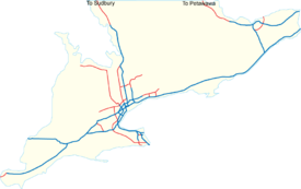
There are 15 different 400-series highways (including the QEW) creating a transportation backbone across the southern portion of the province. Plans are currently underway to extend the existing network into Northern Ontario as well as add new routes into the system. Total length of the entire 400-series system about 1,500 kilometres.| Designation | Image | Alternate names | Length | Opened | North/east end | South/west end | Description | Map |
|---|---|---|---|---|---|---|---|---|
 |
Barrie-Toronto Highway (prior to 1952) | |
|
Highway 559 North of Nobel Nobel, Ontario Nobel is a village located on the shores of Parry Sound, Ontario, Canada. It is located in the Municipality of McDougall in the District of Parry Sound. The community is named after Alfred Nobel, the inventor of dynamite.... (continues as Highway 69 Ontario Highway 69 King's Highway 69, commonly referred to as Highway 69, is a major north–south highway in the central area of the Canadian province of Ontario, linking Highway 400 north of Parry Sound with Sudbury... ) |
Maple Leaf Drive overpass in Toronto Toronto Toronto is the provincial capital of Ontario and the largest city in Canada. It is located in Southern Ontario on the northwestern shore of Lake Ontario. A relatively modern city, Toronto's history dates back to the late-18th century, when its land was first purchased by the British monarchy from... |
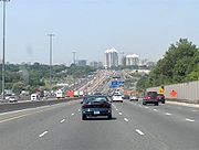
Highway 400 is Toronto's main highway link to York Region, Barrie Barrie, Ontario Barrie is a city in Southern Ontario, Canada, located on the western shore of Lake Simcoe, approximately 90 km north of Toronto. Although located in Simcoe County, the city is politically independent... and Muskoka Muskoka District Municipality, Ontario The District Municipality of Muskoka, more generally referred to as the District of Muskoka, or simply Muskoka, is a Regional Municipality located in Central Ontario, Canada. Muskoka extends from Georgian Bay in the west, to the northern tip of Lake Couchiching in the south, to the western border... . It is the second-longest 400-series highway. Highway 400 is expected to be extended to Sudbury by 2017. |
||
  |
Macdonald-Cartier Freeway; Highway of Heroes (between Don Valley Parkway in Toronto and Trenton) Highland Creek-Newcastle section designated as Highway 2A Highway 2A (Ontario) King's Highway 2A, commonly referred to as Highway 2A, was the designation of five separate provincially maintained highways in the Canadian province of Ontario. Highway 2A was an alternate route to Highway 2 in London, Chatham and Cornwall; these routes were all eventually redesignated... prior to 1952 |
|
|
Quebec Quebec Quebec or is a province in east-central Canada. It is the only Canadian province with a predominantly French-speaking population and the only one whose sole official language is French at the provincial level.... Border (continues as Autoroute 20 Autoroute (Quebec) The Autoroute system is a network of expressways in the province of Quebec, Canada, operating under the same principle of controlled access as the Interstate Highway System in the United States or the 400-Series Highways in neighbouring Ontario. The Autoroutes are the backbone of Quebec's highway... ) |
Highway 3 in Windsor Windsor, Ontario Windsor is the southernmost city in Canada and is located in Southwestern Ontario at the western end of the heavily populated Quebec City – Windsor Corridor. It is within Essex County, Ontario, although administratively separated from the county government. Separated by the Detroit River, Windsor... |
Highway 401 is the backbone of the 400-Series network taking nearly 30 years to be built and running across the entire length of Southern Ontario Southern Ontario Southern Ontario is a region of the province of Ontario, Canada that lies south of the French River and Algonquin Park. Depending on the inclusion of the Parry Sound and Muskoka districts, its surface area would cover between 14 to 15% of the province. It is the southernmost region of... . It has volumes of over 500,000 per day in some areas of Toronto Toronto Toronto is the provincial capital of Ontario and the largest city in Canada. It is located in Southern Ontario on the northwestern shore of Lake Ontario. A relatively modern city, Toronto's history dates back to the late-18th century, when its land was first purchased by the British monarchy from... , making it one of the busiest highway Highway A highway is any public road. In American English, the term is common and almost always designates major roads. In British English, the term designates any road open to the public. Any interconnected set of highways can be variously referred to as a "highway system", a "highway network", or a... s in the world. |
||
 |
Blue Water Bridge Approach Blue Water Bridge The Blue Water Bridge is a twin-span international bridge across the St. Clair River that links Port Huron, Michigan, USA and Sarnia, Ontario, Canada... (prior to 1952) |
|
|
Highway 401 in London London, Ontario London is a city in Southwestern Ontario, Canada, situated along the Quebec City – Windsor Corridor. The city has a population of 352,395, and the metropolitan area has a population of 457,720, according to the 2006 Canadian census; the metro population in 2009 was estimated at 489,274. The city... |
Blue Water Bridge in Point Edward Point Edward, Ontario Point Edward is a village in the Canadian province of Ontario. Adjacent to the city of Sarnia in Lambton County, Point Edward sits opposite Port Huron, Michigan at the mouth of the St. Clair River... (in Sarnia Sarnia, Ontario Sarnia is a city in Southern Ontario, Canada . It is the largest city on Lake Huron and is located where the upper Great Lakes empty into the St. Clair River.... ) |
Highway 402 connects Interstates 69 Interstate 69 Interstate 69 is an Interstate Highway in the United States. It exists in two parts: a completed highway from Indianapolis, Indiana, northeast to the Canadian border in Port Huron, Michigan, and a mostly proposed extension southwest to the Mexican border in Texas... and 94 Interstate 94 Interstate 94 is the northernmost east–west Interstate Highway, connecting the Great Lakes and Intermountain regions of the United States. I-94's western terminus is in Billings, Montana at a junction with Interstate 90; its eastern terminus is the U.S... in Michigan Michigan Michigan is a U.S. state located in the Great Lakes Region of the United States of America. The name Michigan is the French form of the Ojibwa word mishigamaa, meaning "large water" or "large lake".... with the 401 in Ontario. It initially terminated at Highway 40, but was later extended to meet up with Highway 401. |
||
 |
Chedoke Expressway (through Hamilton Hamilton, Ontario Hamilton is a port city in the Canadian province of Ontario. Conceived by George Hamilton when he purchased the Durand farm shortly after the War of 1812, Hamilton has become the centre of a densely populated and industrialized region at the west end of Lake Ontario known as the Golden Horseshoe... ) |
|
|
Highway 401 and Highway 410 in Mississauga | Highway 401 in Woodstock Woodstock, Ontario Woodstock is a city and the county seat of Oxford County in Southern Ontario, Canada. Woodstock is located 128 km southwest of Toronto, north of Highway 401 along the historic Thames River... |
Highway 403 forms a loop that runs from the Highway 401 in Woodstock back to the junction of Highway 401 and Highway 410 in Mississauga, passing through Brantford Brantford, Ontario Brantford is a city located on the Grand River in Southern Ontario, Canada. While geographically surrounded by the County of Brant, the city is politically independent... , Hamilton Hamilton, Ontario Hamilton is a port city in the Canadian province of Ontario. Conceived by George Hamilton when he purchased the Durand farm shortly after the War of 1812, Hamilton has become the centre of a densely populated and industrialized region at the west end of Lake Ontario known as the Golden Horseshoe... , and Mississauga. The section of the QEW between Burlington and Mississauga is shared with Highway 403. Highway 403 is one of three highways (along with highway 404 and the QEW) with high-occupancy vehicle lanes. |
||
 |
commonly referred to as the extension of the Don Valley Parkway Don Valley Parkway The Don Valley Parkway is a controlled-access six-lane municipal expressway in Toronto connecting the Gardiner Expressway in downtown Toronto with Ontario Highway 401, the Macdonald–Cartier Freeway. North of Highway 401, it continues as Ontario Highway 404. The parkway runs through... prior to 1977; Now termed Parkway-404 and vice-versa |
|
|
Herald Road/Green Lane in East Gwillimbury East Gwillimbury, Ontario East Gwillimbury is a town on the East Holland River in the Regional Municipality of York. It is part of the Greater Toronto Area of south-central Ontario, in Canada. It was formed by the amalgamation of the Township of East Gwillimbury with all the previously incorporated villages and hamlets... |
Highway 401 and Don Valley Parkway Don Valley Parkway The Don Valley Parkway is a controlled-access six-lane municipal expressway in Toronto connecting the Gardiner Expressway in downtown Toronto with Ontario Highway 401, the Macdonald–Cartier Freeway. North of Highway 401, it continues as Ontario Highway 404. The parkway runs through... in Toronto Toronto Toronto is the provincial capital of Ontario and the largest city in Canada. It is located in Southern Ontario on the northwestern shore of Lake Ontario. A relatively modern city, Toronto's history dates back to the late-18th century, when its land was first purchased by the British monarchy from... |
Highway 404 is the second north-south freeway in York Region and connects the northeastern suburb Suburb The word suburb mostly refers to a residential area, either existing as part of a city or as a separate residential community within commuting distance of a city . Some suburbs have a degree of administrative autonomy, and most have lower population density than inner city neighborhoods... s and into Toronto as the Don Valley Parkway Don Valley Parkway The Don Valley Parkway is a controlled-access six-lane municipal expressway in Toronto connecting the Gardiner Expressway in downtown Toronto with Ontario Highway 401, the Macdonald–Cartier Freeway. North of Highway 401, it continues as Ontario Highway 404. The parkway runs through... . It is one of three highways (along with Highway 403 and the QEW) with high-occupancy vehicle lanes and the only one with a dedicated HOV off-ramp, which serves Highway 401 westbound from Highway 404 southbound. |
||
 |
General Brock Parkway (since 2006) | |
|
Lewiston-Queenston Bridge Lewiston-Queenston Bridge The Lewiston–Queenston Bridge is an arch bridge that crosses the Niagara River gorge just south of the Niagara Escarpment. The bridge was officially opened on November 1, 1962. It is an international bridge between the United States and Canada. It connects Interstate 190 in the town of Lewiston,... (connects to the United States United States The United States of America is a federal constitutional republic comprising fifty states and a federal district... ) |
Queen Elizabeth Way, west of Niagara Falls | Though a short spur route, Highway 405 is still considered a major highway connecting the main trunk highway to Toronto (the QEW) with Interstate 190 Interstate 190 (New York) Interstate 190 runs 28.34 miles from Interstate 90 near Buffalo, New York to Lewiston, New York via Niagara Falls. Parts of this highway were built on the former rights-of-way of the Lehigh Valley Railroad and the Erie Canal. It is referred to by locals as The One-Ninety... outside of Niagara Falls Niagara Falls, New York Niagara Falls is a city in Niagara County, New York, United States. As of the 2010 census, the city had a total population of 50,193, down from the 55,593 recorded in the 2000 census. It is across the Niagara River from Niagara Falls, Ontario , both named after the famed Niagara Falls which they... , New York New York New York is a state in the Northeastern region of the United States. It is the nation's third most populous state. New York is bordered by New Jersey and Pennsylvania to the south, and by Connecticut, Massachusetts and Vermont to the east... . |
||
 |
|
|
Queen Elizabeth Way in St. Catharines St. Catharines, Ontario St. Catharines is the largest city in Canada's Niagara Region and the sixth largest urban area in Ontario, Canada, with 97.11 square kilometres of land... |
East Main Street (Highway 7146) in Welland Welland, Ontario Welland is a city in the Regional Municipality of Niagara in Southern Ontario, Canada.The city has been traditionally known as the place where rails and water meet, referring to the railways from Buffalo to Toronto and Southwestern Ontario, and the waterways of Welland Canal and Welland River,... |
Highway 406 is the last remaining 400-series highway under Ministry of Transportation jurisdiction with two-lane non-freeway sections, located between Thorold Thorold, Ontario Thorold is a city in Ontario, Canada, located on the Niagara Escarpment. It is also the seat of the Regional Municipality of Niagara.... and Welland. Plans to extend the route further south to the proposed Mid-Peninsula Highway Mid-Peninsula Highway The Mid-Peninsula Highway is a proposed freeway across the Niagara Peninsula in the Canadian province of Ontario. Although plans for a highway connecting Hamilton to Fort Erie south of the Niagara Escarpment have surfaced for decades,... have been voiced. |
|||
 |
 |
Express Toll Route | |
|
Highway 7, near Brock Road in Pickering Pickering, Ontario Pickering is a city located in Southern Ontario, Canada immediately east of Toronto in Durham Region. It is part of the Greater Toronto Area, the largest metropolitan area in Canada.- Early Period :... |
Junction of Highway 403 and the Queen Elizabeth Way in Burlington Burlington, Ontario Burlington , is a city located in Halton Region at the western end of Lake Ontario. Burlington is part of the Greater Toronto Area, and is also included in the Hamilton Census Metropolitan Area. Physically, Burlington lies between the north shore of Lake Ontario and the Niagara Escarpment... |
Highway 407 forms a northern bypass for Highway 401 and the Queen Elizabeth Way through the Greater Toronto Area Greater Toronto Area The Greater Toronto Area is the largest metropolitan area in Canada, with a 2006 census population of 5.5 million. The Greater Toronto Area is usually defined as the central city of Toronto, along with four regional municipalities surrounding it: Durham, Halton, Peel, and York... . It is Ontario's only toll highway and was the first highway to use electronic toll collection exclusively for its entire length. Owned by Cintra Cintra Cintra, S.A. is one of the largest private developers of transport infrastructure in the world. Its assets are fundamentally toll roads and car parks, in which it has a total investment of €16billion... , it is not officially considered part of the King's Highway system. |
|
 |
formerly known as the Belfield Expressway | |
|
Highway 401 in Toronto Toronto Toronto is the provincial capital of Ontario and the largest city in Canada. It is located in Southern Ontario on the northwestern shore of Lake Ontario. A relatively modern city, Toronto's history dates back to the late-18th century, when its land was first purchased by the British monarchy from... |
Airport Road in Mississauga | Highway 409 is a short connector route from the 401 to Toronto Pearson International Airport Toronto Pearson International Airport Toronto Pearson International Airport is an international airport serving Toronto, Ontario, Canada; its metropolitan area; and the Golden Horseshoe, an urban agglomeration that is home to 8.1 million people – approximately 25% of Canada's population... . A short section of the route between Airport Road and Highway 427 in Mississauga is under the jurisdiction of the Greater Toronto Airport Authority. |
||
 |
Brampton Bypass | |
|
Hurontario Street Hurontario Street Hurontario Street is a roadway running in Ontario, Canada between Lake Ontario at Mississauga and Lake Huron's Georgian Bay at Collingwood.Within the cities of Mississauga and Brampton, it is a major urban thoroughfare. Between Caledon and Orangeville, it is part of busy Highway 10, which leaves... / Highway 10 Highway 10 (Ontario) King's Highway 10, commonly referred to as Highway 10 and historically as the Toronto–Sydenham Road, is a provincially maintained highway in the Canadian province of Ontario... in Brampton Brampton Brampton is the third-largest city in the Greater Toronto Area of Ontario, Canada.Brampton may also refer to:- Canada :* Brampton, a city in Ontario** Brampton GO Station, a station in the GO Transit network located in the city- United Kingdom :... |
Highway 401 in Mississauga | Highway 410 runs from the junction of Highway 401 and Highway 403 in Mississauga through Northern Mississauga and Brampton Brampton Brampton is the third-largest city in the Greater Toronto Area of Ontario, Canada.Brampton may also refer to:- Canada :* Brampton, a city in Ontario** Brampton GO Station, a station in the GO Transit network located in the city- United Kingdom :... . |
||
 |
Veterans Memorial Highway | |
|
Highway 417 in Ottawa Ottawa Ottawa is the capital of Canada, the second largest city in the Province of Ontario, and the fourth largest city in the country. The city is located on the south bank of the Ottawa River in the eastern portion of Southern Ontario... |
Highway 401, north of Johnstown and the Ogdensburg–Prescott International Bridge | Highway 416, except for its northernmost 21 kilometres, follows the former route of Highway 16. It is the newest 400-Series highway to be built and owned by the Ministry of Transportation and is the main link (via the 401 and I-81 Interstate 81 Interstate 81 is an Interstate Highway in the eastern part of the United States. Its southern terminus is at Interstate 40 in Dandridge, Tennessee; its northern terminus is on Wellesley Island at the Canadian border, where the Thousand Islands Bridge connects it to Highway 401, the main freeway... ) between the US and the National Capital Region National Capital Region (Canada) The National Capital Region, also referred to as Canada's Capital Region, is an official federal designation for the Canadian capital of Ottawa, Ontario, the neighbouring city of Gatineau, Quebec, and surrounding urban and rural communities.... . It was officially completed on September 23, 1999. |
||
 |
Queensway Queensway (Ottawa) The Queensway is a major controlled-access freeway running through Ottawa, Ontario, Canada, from Kanata in the west to Orleans in the east. It is the primary east-west transportation artery in the Ottawa-Gatineau area.... (through most of Ottawa) |
|
|
Quebec Quebec Quebec or is a province in east-central Canada. It is the only Canadian province with a predominantly French-speaking population and the only one whose sole official language is French at the provincial level.... border (continues as Autoroute 40 Autoroute (Quebec) The Autoroute system is a network of expressways in the province of Quebec, Canada, operating under the same principle of controlled access as the Interstate Highway System in the United States or the 400-Series Highways in neighbouring Ontario. The Autoroutes are the backbone of Quebec's highway... ) |
Arnprior Arnprior, Ontario Arnprior is a town in Renfrew County, in the eastern portion of Southern Ontario, Canada. It is located at the mouth of the Madawaska River, as it enters the Ottawa River in the Ottawa Valley... (continues as Highway 17) |
Highway 417 is the main freeway through Ottawa Ottawa Ottawa is the capital of Canada, the second largest city in the Province of Ontario, and the fourth largest city in the country. The city is located on the south bank of the Ottawa River in the eastern portion of Southern Ontario... and Eastern Ontario Eastern Ontario Eastern Ontario is a subregion of Southern Ontario in the Canadian province of Ontario which lies in a wedge-shaped area between the Ottawa River and St. Lawrence River... along the Ottawa River Ottawa River The Ottawa River is a river in the Canadian provinces of Ontario and Quebec. For most of its length, it now defines the border between these two provinces.-Geography:... and Quebec Quebec Quebec or is a province in east-central Canada. It is the only Canadian province with a predominantly French-speaking population and the only one whose sole official language is French at the provincial level.... border. The Ministry of Transportation hopes to eventually extend the 417 through the Ottawa Valley. Its mileage logs, unlike most other east-west highways in Ontario, begins at the eastern terminus rather than the west. |
||
 |
Rainbow Bridge terminus of the Queen Elizabeth Way prior to 1972 | |
|
Stanley Ave in Niagara Falls Niagara Falls, Ontario Niagara Falls is a Canadian city on the Niagara River in the Golden Horseshoe region of Southern Ontario. The municipality was incorporated on June 12, 1903... , where it continues to the Rainbow Bridge Rainbow Bridge (Niagara Falls) The Rainbow Bridge at Niagara Falls is an international steel arch bridge across the Niagara River gorge, and is a world-famous tourist site. It connects the cities of Niagara Falls, New York, United States , and Niagara Falls, Ontario, Canada .-Construction:The Rainbow Bridge was built near the... as Regional Road 420. |
Montrose Road in Niagara Falls Niagara Falls, Ontario Niagara Falls is a Canadian city on the Niagara River in the Golden Horseshoe region of Southern Ontario. The municipality was incorporated on June 12, 1903... |
Highway 420 connects the QEW to the tourist district in Niagara Falls. Portions of it were transferred to the City of Niagara Falls in 2000 and became Regional Road 420. The Ministry of Transportation hopes to extend the 420 west past Montrose Road to meet up with Highway 58 Highway 58 (Ontario) King's Highway 58, commonly referred to as Highway 58, is a provincially maintained highway in the Canadian province of Ontario. Highway 58 currently runs from the Highway 406 junction on the St. Catharines – Thorold boundary to the Highway 406 junction near Turner's Corners, all... and the Thorold Tunnel Thorold Tunnel The Thorold Tunnel, located in Thorold, Ontario, Canada, is an underwater tunnel, carrying Highway 58 underneath the Welland Canal. Built between 1965 and 1967, the tunnel is 840 metres in length. It consists of two separate tubes, each two lanes wide... . |
||
 |
known as Airport Expressway (between Highway 401 and Highway 409) prior to 1972 | |
|
Highway 7 in Vaughan Vaughan, Ontario Vaughan is a city in York Region north of Toronto, Ontario, Canada. Vaughan is the fastest growing municipality in Canada achieving a population growth rate of 80.2% between 1996–2006, according to Statistics Canada having nearly doubled in population since 1991. Vaughan is located in Southern... (Unofficially to Zenway Blvd) |
Evans Ave in Toronto Toronto Toronto is the provincial capital of Ontario and the largest city in Canada. It is located in Southern Ontario on the northwestern shore of Lake Ontario. A relatively modern city, Toronto's history dates back to the late-18th century, when its land was first purchased by the British monarchy from... |
Highway 427 serves the heavy-travelled area between the Queen Elizabeth Way and Gardiner Expressway Gardiner Expressway The Frederick G. Gardiner Expressway, colloquially referred to as "the Gardiner", is a municipal expressway in the Canadian province of Ontario, connecting downtown Toronto with its western suburbs... in the south and Highway 7 in the north. It has heavy traffic volumes and occupies no less than 12 lanes between the Queen Elizabeth Way/Gardiner Expressway and Highway 401. |
||
| Queen Elizabeth Way The Queen Elizabeth Way, commonly abbreviated as the QEW, is a 400-Series highway in the Canadian province of Ontario. The freeway links Buffalo, New York and the Niagara Peninsula with Toronto. It begins at the Peace Bridge in Fort Erie and travels around the western shore of Lake Ontario, ending...  |
Referred to as Highway 451 or Highway 1 on some MTO documents. | |
|
Peace Bridge Peace Bridge The Peace Bridge is an international bridge between Canada and the United States at the east end of Lake Erie at the source of the Niagara River, about upriver of Niagara Falls. It connects the City of Buffalo, New York, in the United States to the Town of Fort Erie, Ontario, in Canada... in Fort Erie Fort Erie, Ontario Fort Erie is a town on the Niagara River in the Niagara Region, Ontario, Canada. It is located directly across the river from Buffalo, New York.... |
Highway 427 in Toronto Toronto Toronto is the provincial capital of Ontario and the largest city in Canada. It is located in Southern Ontario on the northwestern shore of Lake Ontario. A relatively modern city, Toronto's history dates back to the late-18th century, when its land was first purchased by the British monarchy from... , where it continues as the Gardiner Expressway Gardiner Expressway The Frederick G. Gardiner Expressway, colloquially referred to as "the Gardiner", is a municipal expressway in the Canadian province of Ontario, connecting downtown Toronto with its western suburbs... Humber River before the 1998 provincial downloading. |
The QEW is North America's North America North America is a continent wholly within the Northern Hemisphere and almost wholly within the Western Hemisphere. It is also considered a northern subcontinent of the Americas... oldest long-distance superhighway. It is not referred to by a route number, but does have several internal designations, including Highway 1 and Highway 451, and is considered part of the 400-Series network. It also uses city names rather than cardinal direction Cardinal direction The four cardinal directions or cardinal points are the directions of north, east, south, and west, commonly denoted by their initials: N, E, S, W. East and west are at right angles to north and south, with east being in the direction of rotation and west being directly opposite. Intermediate... s to direct (and to not confuse) motorists. The QEW is one of three highways (along with highway 403 and highway 404) with high-occupancy vehicle lanes. |
Former 400-series highways
Due to government restructuring in 1997 and 1998, various sections of provincial highway were transferred over to local jurisdictions. While most of the highways transferred were local in nature, several large routes including freeways were transferred to local governments.| Designation | Total length (km) | Year inaugurated | Year decommissioned | North/east end | South/west end | Current status | Description |
|---|---|---|---|---|---|---|---|
| Highway 400A (Ontario) King's Highway 400A, once known as the Highway 400 Extension, is an unsigned 400-series highway in the Canadian province of Ontario. The short freeway stub connects Highway 400 with Highway 11 and Simcoe County Road 93, formerly Highway 93... |
|
|
|
Highway 11 in Barrie Barrie, Ontario Barrie is a city in Southern Ontario, Canada, located on the western shore of Lake Simcoe, approximately 90 km north of Toronto. Although located in Simcoe County, the city is politically independent... , Ontario Ontario Ontario is a province of Canada, located in east-central Canada. It is Canada's most populous province and second largest in total area. It is home to the nation's most populous city, Toronto, and the nation's capital, Ottawa.... |
Highway 400 in Barrie Barrie, Ontario Barrie is a city in Southern Ontario, Canada, located on the western shore of Lake Simcoe, approximately 90 km north of Toronto. Although located in Simcoe County, the city is politically independent... , Ontario Ontario Ontario is a province of Canada, located in east-central Canada. It is Canada's most populous province and second largest in total area. It is home to the nation's most populous city, Toronto, and the nation's capital, Ottawa.... |
Section of Highway 11 | Highway 400A was a short spur connecting Highway 400 to the Highway 11 expressway Limited-access road A limited-access road known by various terms worldwide, including limited-access highway, dual-carriageway and expressway, is a highway or arterial road for high-speed traffic which has many or most characteristics of a controlled-access highway , including limited or no access to adjacent... northeast of Barrie Barrie, Ontario Barrie is a city in Southern Ontario, Canada, located on the western shore of Lake Simcoe, approximately 90 km north of Toronto. Although located in Simcoe County, the city is politically independent... . It was initially part of Highway 400 until 1960, when a new section of Highway 400 opened, bypassing 1.1 km of freeway, which was re-numbered Highway 400A and became the shortest 400-series highway. |
| |
|
|
|
Highway 401 in Windsor Windsor, Ontario Windsor is the southernmost city in Canada and is located in Southwestern Ontario at the western end of the heavily populated Quebec City – Windsor Corridor. It is within Essex County, Ontario, although administratively separated from the county government. Separated by the Detroit River, Windsor... , Ontario Ontario Ontario is a province of Canada, located in east-central Canada. It is Canada's most populous province and second largest in total area. It is home to the nation's most populous city, Toronto, and the nation's capital, Ottawa.... |
Highway 3B Highway 3B (Ontario) Not to be confused with the Highway 3B that became Highway 51, in Norfolk County.King's Highway 3B was a provincially maintained highway in Windsor... (Howard Avenue) in Windsor Windsor, Ontario Windsor is the southernmost city in Canada and is located in Southwestern Ontario at the western end of the heavily populated Quebec City – Windsor Corridor. It is within Essex County, Ontario, although administratively separated from the county government. Separated by the Detroit River, Windsor... , Ontario Ontario Ontario is a province of Canada, located in east-central Canada. It is Canada's most populous province and second largest in total area. It is home to the nation's most populous city, Toronto, and the nation's capital, Ottawa.... |
Maintained as Dougall Parkway by City of Windsor Windsor, Ontario Windsor is the southernmost city in Canada and is located in Southwestern Ontario at the western end of the heavily populated Quebec City – Windsor Corridor. It is within Essex County, Ontario, although administratively separated from the county government. Separated by the Detroit River, Windsor... |
Highway 401A (also referred to as Highway 3B) was the original alignment of Highway 401, from 1952 until 1964, before it was re-routed to connect directly to Highway 3 Highway 3 (Ontario) King's Highway 3, commonly referred to as Highway 3 and historically as the Talbot Trail, is a provincially maintained highway in the Canadian province of Ontario which travels parallel to the shore of Lake Erie. It has three segments, the first of which runs from the Ambassador Bridge in Windsor... . It was downloaded to the City of Windsor in 1997 and has since been renovated. |
| Queen Elizabeth Way The Queen Elizabeth Way, commonly abbreviated as the QEW, is a 400-Series highway in the Canadian province of Ontario. The freeway links Buffalo, New York and the Niagara Peninsula with Toronto. It begins at the Peace Bridge in Fort Erie and travels around the western shore of Lake Ontario, ending... (east of Highway 427) |
|
|
|
Gardiner Expressway Gardiner Expressway The Frederick G. Gardiner Expressway, colloquially referred to as "the Gardiner", is a municipal expressway in the Canadian province of Ontario, connecting downtown Toronto with its western suburbs... in Toronto Toronto Toronto is the provincial capital of Ontario and the largest city in Canada. It is located in Southern Ontario on the northwestern shore of Lake Ontario. A relatively modern city, Toronto's history dates back to the late-18th century, when its land was first purchased by the British monarchy from... , Ontario Ontario Ontario is a province of Canada, located in east-central Canada. It is Canada's most populous province and second largest in total area. It is home to the nation's most populous city, Toronto, and the nation's capital, Ottawa.... |
Highway 427 in Toronto Toronto Toronto is the provincial capital of Ontario and the largest city in Canada. It is located in Southern Ontario on the northwestern shore of Lake Ontario. A relatively modern city, Toronto's history dates back to the late-18th century, when its land was first purchased by the British monarchy from... , Ontario Ontario Ontario is a province of Canada, located in east-central Canada. It is Canada's most populous province and second largest in total area. It is home to the nation's most populous city, Toronto, and the nation's capital, Ottawa.... |
Section of the Gardiner Expressway Gardiner Expressway The Frederick G. Gardiner Expressway, colloquially referred to as "the Gardiner", is a municipal expressway in the Canadian province of Ontario, connecting downtown Toronto with its western suburbs... |
This segment of the QEW was transferred to the City of Toronto in 1997 as a cost savings measure by the Ontario provincial government. It has since been re-designated as a western extension of the Gardiner Expressway. |
Future additions
Ontario
Ontario is a province of Canada, located in east-central Canada. It is Canada's most populous province and second largest in total area. It is home to the nation's most populous city, Toronto, and the nation's capital, Ottawa....
, specifically Southern Ontario
Southern Ontario
Southern Ontario is a region of the province of Ontario, Canada that lies south of the French River and Algonquin Park. Depending on the inclusion of the Parry Sound and Muskoka districts, its surface area would cover between 14 to 15% of the province. It is the southernmost region of...
. Some of these new routes may be toll roads owned and operated in a similar fashion to Highway 407. In addition, the long-term extension of Highway 417 towards North Bay (and beyond), as well as construction of a staged freeway on the Highway 11 corridor, would likely absorb the existing freeway sections of Highway 11 and Highway 17 into 400-series highways. Also, a highway to connect the City of Guelph to highway 410 and later 400 is in the planning stages.
HOV lanes
The Ontario Ministry of Transportation has announced a major expansion of HOV lanes within the Golden HorseshoeGolden Horseshoe
The Golden Horseshoe is a densely populated and industrialized region centred around the Greater Toronto Area at the western end of Lake Ontario in Southern Ontario, Canada, with outer boundaries stretching south to Lake Erie and north to Georgian Bay. Most of it is also part of the Quebec City...
, and the National Capital Region
National Capital Region (Canada)
The National Capital Region, also referred to as Canada's Capital Region, is an official federal designation for the Canadian capital of Ottawa, Ontario, the neighbouring city of Gatineau, Quebec, and surrounding urban and rural communities....
. The first HOV lanes in the Greater Toronto Area (GTA) were introduced to Highway 404 (southbound) from Beaver Creek (between Highway 7 and 16th Avenue) in York Region to Highway 401/Don Valley Parkway
Don Valley Parkway
The Don Valley Parkway is a controlled-access six-lane municipal expressway in Toronto connecting the Gardiner Expressway in downtown Toronto with Ontario Highway 401, the Macdonald–Cartier Freeway. North of Highway 401, it continues as Ontario Highway 404. The parkway runs through...
in Toronto
Toronto
Toronto is the provincial capital of Ontario and the largest city in Canada. It is located in Southern Ontario on the northwestern shore of Lake Ontario. A relatively modern city, Toronto's history dates back to the late-18th century, when its land was first purchased by the British monarchy from...
. An exclusive HOV ramp/tunnel from the Highway 404 HOV lane to the Highway 401 westbound collectors was also built at the same time in Toronto
Toronto
Toronto is the provincial capital of Ontario and the largest city in Canada. It is located in Southern Ontario on the northwestern shore of Lake Ontario. A relatively modern city, Toronto's history dates back to the late-18th century, when its land was first purchased by the British monarchy from...
. In addition, HOV lanes were introduced on Highway 403 from Highway 401/Highway 410 to Highway 407 in Mississauga.
In May 2007, the Ministry of Transportation introduced a multi-billion dollar Horseshoe Network Project, which includes plans to incorporate HOV lanes into numerous 400-series highways. On July 23, 2007, an HOV lane was opened on Highway 404 (northbound) from the north of Sheppard Ave to Highway 7, matching the current southbound HOV lane.
More than 450 kilometres of HOV lanes are expected to be implemented in 400-series highways. The general goals of the project is to help increase highway efficiency (an HOV lane is expected to have the ability to move as many people as four general-purpose lanes), reduce congestion, conserve energy and help protect the environment.
Project plan
| Highway | Starting location | Terminating location | General location |
|---|---|---|---|
| Near-term (2007—2011) | |||
| QEW | Burloak Drive | 3rd Line | Region of Halton Regional Municipality of Halton, Ontario The Regional Municipality of Halton, or Halton Region, is a regional municipality of Ontario, Canada located in Southern Ontario in the southwest part of the Greater Toronto Area and until 1973 was known as Halton County... |
| Burloak Drive | Guelph Line | ||
| 3rd Line | Trafalgar Road | ||
| 427 | Highway 409 | Highway 407 | near Pearson International Airport Toronto Pearson International Airport Toronto Pearson International Airport is an international airport serving Toronto, Ontario, Canada; its metropolitan area; and the Golden Horseshoe, an urban agglomeration that is home to 8.1 million people – approximately 25% of Canada's population... in Toronto Toronto Toronto is the provincial capital of Ontario and the largest city in Canada. It is located in Southern Ontario on the northwestern shore of Lake Ontario. A relatively modern city, Toronto's history dates back to the late-18th century, when its land was first purchased by the British monarchy from... |
| 400 | Major Mackenzie Drive W. | Kirby Road/King Road | Region of York Regional Municipality of York, Ontario The Regional Municipality of York, also called York Region, is a regional municipality in Southern Ontario, Canada, between Lake Simcoe and Toronto. It replaced the former York County in 1971, and is part of the Greater Toronto Area and the inner ring of the Golden Horseshoe... |
| Mid-term (2011—2017) | |||
| 401 | Mississauga Road | Highway 403 | Mississauga |
| 400 | Kirby Road/King Road | Highway 9 | Region of York |
| 404 | Highway 7 | Aurora Road | |
| Long-term (2017—) | |||
| QEW | Red Hill Valley Parkway Red Hill Valley Parkway The Red Hill Valley Parkway , referred to as the Red Hill Creek Expressway during planning is a municipal expressway in the Canadian city of Hamilton, Ontario. The route connects the Lincoln M. Alexander Parkway, Hamilton's second municipal expressway, to the Queen Elizabeth Way near Hamilton... |
Highway 406 | Hamilton Hamilton, Ontario Hamilton is a port city in the Canadian province of Ontario. Conceived by George Hamilton when he purchased the Durand farm shortly after the War of 1812, Hamilton has become the centre of a densely populated and industrialized region at the west end of Lake Ontario known as the Golden Horseshoe... and Region of Niagara |
| 407/403 | Guelph Line | Burlington Burlington, Ontario Burlington , is a city located in Halton Region at the western end of Lake Ontario. Burlington is part of the Greater Toronto Area, and is also included in the Hamilton Census Metropolitan Area. Physically, Burlington lies between the north shore of Lake Ontario and the Niagara Escarpment... |
|
| Trafalgar Road | Highway 427 | Oakville Oakville, Ontario Oakville is a town in Halton Region, on Lake Ontario in Southern Ontario, Canada, and is part of the Greater Toronto Area. As of the 2006 census the population was 165,613.-History:In 1793, Dundas Street was surveyed for a military road... and Mississauga |
|
| 403 | Highway 6 | Highway 407/Queen Elizabeth Way | Hamilton and Burlington |
| QEW | Highway 407 | Mississauga | |
| 400 | Highway 9 | Highway 88/Barrie Barrie, Ontario Barrie is a city in Southern Ontario, Canada, located on the western shore of Lake Simcoe, approximately 90 km north of Toronto. Although located in Simcoe County, the city is politically independent... |
Region of York Regional Municipality of York, Ontario The Regional Municipality of York, also called York Region, is a regional municipality in Southern Ontario, Canada, between Lake Simcoe and Toronto. It replaced the former York County in 1971, and is part of the Greater Toronto Area and the inner ring of the Golden Horseshoe... and Simcoe County Simcoe County, Ontario Simcoe County is located in central portion of Southern Ontario. The County is situated just north of the Greater Toronto Area stretching from the shores of Lake Simcoe in the east to Georgian Bay in the west... |
| 401 | Milton Milton, Ontario Milton is a town in Southern Ontario, Canada, and part of the Halton Region in the Greater Toronto Area. Milton received a tremendous amount of awareness following the release of the results of the 2006 Census, which indicated that Milton is the fastest growing municipality in the Greater Golden... |
Mississauga Road | |
| Brock Road | Ritson Road | Region of Durham Regional Municipality of Durham, Ontario The Regional Municipality of Durham, informally referred to as Durham Region, is a regional municipality located in Southern Ontario east of Toronto, Ontario. It has an area of approximately 2,500 square kilometres. Durham Region is considered part of the Greater Toronto Area, with the communities... |
|
| 404 | Aurora Road | Keswick Keswick, Ontario Keswick is a community in the south central portion of the Canadian province of Ontario. Located north of Toronto on Cook's Bay , Keswick is part of the Town of Georgina... |
Region of York Regional Municipality of York, Ontario The Regional Municipality of York, also called York Region, is a regional municipality in Southern Ontario, Canada, between Lake Simcoe and Toronto. It replaced the former York County in 1971, and is part of the Greater Toronto Area and the inner ring of the Golden Horseshoe... |
| 410 | Highway 401 | Queen Street | Brampton Brampton Brampton is the third-largest city in the Greater Toronto Area of Ontario, Canada.Brampton may also refer to:- Canada :* Brampton, a city in Ontario** Brampton GO Station, a station in the GO Transit network located in the city- United Kingdom :... |
Future 400-series highways
| Designation | Alternate names | Planned inauguration year | Planned north/east end | Planned south/west end | Current status | Description |
|---|---|---|---|---|---|---|
| |
Mid-Peninsula Highway The Mid-Peninsula Highway is a proposed freeway across the Niagara Peninsula in the Canadian province of Ontario. Although plans for a highway connecting Hamilton to Fort Erie south of the Niagara Escarpment have surfaced for decades,... |
|
Queen Elizabeth Way in Fort Erie Fort Erie, Ontario Fort Erie is a town on the Niagara River in the Niagara Region, Ontario, Canada. It is located directly across the river from Buffalo, New York.... , Ontario Ontario Ontario is a province of Canada, located in east-central Canada. It is Canada's most populous province and second largest in total area. It is home to the nation's most populous city, Toronto, and the nation's capital, Ottawa.... |
Highway 407 in Burlington Burlington, Ontario Burlington , is a city located in Halton Region at the western end of Lake Ontario. Burlington is part of the Greater Toronto Area, and is also included in the Hamilton Census Metropolitan Area. Physically, Burlington lies between the north shore of Lake Ontario and the Niagara Escarpment... , or Highway 401 near Milton Milton, Ontario Milton is a town in Southern Ontario, Canada, and part of the Halton Region in the Greater Toronto Area. Milton received a tremendous amount of awareness following the release of the results of the 2006 Census, which indicated that Milton is the fastest growing municipality in the Greater Golden... |
|
The Mid-Peninsula Highway will serve as southern bypass of the QEW through the environmentally sensitive Niagara Peninsula Niagara Peninsula The Niagara Peninsula is the portion of Southern Ontario, Canada lying between the south shore of Lake Ontario and the north shore of Lake Erie. It stretches from the Niagara River in the east to Hamilton, Ontario in the west. The population of the peninsula is roughly 1,000,000 people... . It is a highly controversial project as it will likely run through tender agricultural areas and the Niagara Escarpment Niagara Escarpment The Niagara Escarpment is a long escarpment, or cuesta, in the United States and Canada that runs westward from New York State, through Ontario, Michigan, Wisconsin and Illinois... , and many question the need of the highway. |
| |
Bradford Bypass The Bradford Bypass is a proposed freeway that would travel near Bradford, in the Canadian province of Ontario. The route would serve as a connector between Highway 400 and Highway 404 on the northern edge of the Greater Toronto Area, in York Region and Simcoe County.The planned western... |
|
Highway 404 near Queensville | Highway 400 near Bradford Bradford, Ontario Bradford is the primary country urban area of the Town of Bradford West Gwillimbury, Ontario, in Canada. It overlooks a beautiful and prosperous farming community, known as The Holland Marsh, located on the Holland River that flows into Lake Simcoe... , or Highway 427 near Bond Head |
|
The Bradford Bypass will serve as a connector between Highways 400 and 404 on the northern portion of the Greater Toronto Area Greater Toronto Area The Greater Toronto Area is the largest metropolitan area in Canada, with a 2006 census population of 5.5 million. The Greater Toronto Area is usually defined as the central city of Toronto, along with four regional municipalities surrounding it: Durham, Halton, Peel, and York... . Predominantly a local issue, as the province does not consider the bypass a priority. |
| |
|
|
Highway 407, just east of the proposed Pickering Airport Pickering Airport Pickering Airport is a proposed international airport for the Greater Toronto Area, to be located in the city of Pickering, Ontario, Canada, 50 kilometres north-east of downtown Toronto, and 65 kilometres east of Toronto Pearson International Airport... |
Highway 401 on the Ajax Ajax, Ontario Ajax is a town in the Durham Region in the Greater Toronto Area.The town is named for the HMS Ajax a Royal Navy cruiser that served in World War II. Ajax is a part of the Greater Toronto Area and the... /Whitby Whitby, Ontario Whitby is a town in Durham Region. Whitby is located in Southern Ontario east of Toronto on the north shore of Lake Ontario, and is home to the headquarters of Durham Region... border |
|
The West Durham Link will serve as a connector between Highway 401 and Highway 407 east of Lakeridge Road. Plans for this new freeway will see it located near Lake Ridge Road between Ajax and Whitby. |
| |
|
|
Highway 407 | Highway 401 in Clarington Clarington, Ontario Clarington is a municipality in Ontario, Canada in the Regional Municipality of Durham. It took its present name in 1994 after having been known as the Town of Newcastle from 1974-93. The name change was made to alleviate long-standing confusion between the municipality as a whole and the included... , in the community of Courtice Courtice, Ontario Courtice is a community located in Ontario, Canada, about sixty kilometers east of Toronto, adjacent to Oshawa and west of Bowmanville in the Municipality of Clarington. Courtice Road connects with Highway 401 at Interchange 425, providing arterial access to the community... |
|
The East Durham Link will serve the east end of Durham Region, including Oshawa Oshawa, Ontario Oshawa is a city in Ontario, Canada, on the Lake Ontario shoreline. It lies in Southern Ontario approximately 60 kilometres east of downtown Toronto. It is commonly viewed as the eastern anchor of both the Greater Toronto Area and the Golden Horseshoe. It is now commonly referred to as the most... and Clarington. The alignment will be located east of Courtice Road in Clarington. |
See also
- List of Ontario expressways
- List of Ontario provincial highways
- 100-Series Highways of Nova Scotia
- Quebec AutoroutesAutoroute (Quebec)The Autoroute system is a network of expressways in the province of Quebec, Canada, operating under the same principle of controlled access as the Interstate Highway System in the United States or the 400-Series Highways in neighbouring Ontario. The Autoroutes are the backbone of Quebec's highway...