
.gif)
Highway 115 (Ontario)
Encyclopedia
Canada
Canada is a North American country consisting of ten provinces and three territories. Located in the northern part of the continent, it extends from the Atlantic Ocean in the east to the Pacific Ocean in the west, and northward into the Arctic Ocean...
province of Ontario
Ontario
Ontario is a province of Canada, located in east-central Canada. It is Canada's most populous province and second largest in total area. It is home to the nation's most populous city, Toronto, and the nation's capital, Ottawa....
that connects Peterborough
Peterborough, Ontario
Peterborough is a city on the Otonabee River in southern Ontario, Canada, 125 kilometres northeast of Toronto. The population of the City of Peterborough was 74,898 as of the 2006 census, while the census metropolitan area has a population of 121,428 as of a 2009 estimate. It presently ranks...
with Toronto
Toronto
Toronto is the provincial capital of Ontario and the largest city in Canada. It is located in Southern Ontario on the northwestern shore of Lake Ontario. A relatively modern city, Toronto's history dates back to the late-18th century, when its land was first purchased by the British monarchy from...
via Highway 401. The highway begins at a junction with Highway 401 southwest of Newcastle
Newcastle, Ontario
Newcastle is a community in the Municipality of Clarington in Durham Region, Ontario, Canada. The Town of Newcastle was also the original name of what is now Clarington....
and becomes Highway 7
Ontario Highway 7
King's Highway 7, commonly referred to as Highway 7 and historically as the Northern Highway, is a provincially maintained highway in the Canadian province of Ontario...
at an at-grade intersection east of Peterborough
Peterborough, Ontario
Peterborough is a city on the Otonabee River in southern Ontario, Canada, 125 kilometres northeast of Toronto. The population of the City of Peterborough was 74,898 as of the 2006 census, while the census metropolitan area has a population of 121,428 as of a 2009 estimate. It presently ranks...
.
Highway 115 is part of the Algonquin Trail and concurrent
Concurrency (road)
A concurrency, overlap, or coincidence in a road network is an instance of one physical road bearing two or more different highway, motorway, or other route numbers...
with Highway 35 from its southern terminus in Clarington
Clarington, Ontario
Clarington is a municipality in Ontario, Canada in the Regional Municipality of Durham. It took its present name in 1994 after having been known as the Town of Newcastle from 1974-93. The name change was made to alleviate long-standing confusion between the municipality as a whole and the included...
to Enterprise Hill, where it veers towards Peterborough and Highway 35 continues north into the Kawarthas
Kawartha Lakes
The city of Kawartha Lakes is a unitary municipality in Central Ontario, Canada. Although called a city, Kawartha Lakes is the size of a typical Ontarian county and is mostly rural....
. It is also part of the Trans-Canada Highway
Trans-Canada Highway
The Trans-Canada Highway is a federal-provincial highway system that joins the ten provinces of Canada. It is, along with the Trans-Siberian Highway and Australia's Highway 1, one of the world's longest national highways, with the main route spanning 8,030 km...
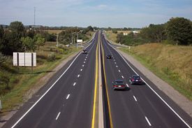
from the interchange with Highway 7 south of Springville, Ontario to the eastern end of the highway. Highway 115 is a freeway
Controlled-access highway
A controlled-access highway is a highway designed exclusively for high-speed vehicular traffic, with all traffic flow and ingress/egress regulated...
northeast of Enterprise Hill and a Right-in/right-out
Right-in/right-out
Right-in/right-out and left-in/left-out refer to a type of road intersection where turning movements of vehicles are restricted. A RIRO permits only right turns and a LILO permits only left turns. RIRO is usual where vehicles drive on the right, and LILO is usual where vehicles drive on the left...
(RIRO) expressway
Limited-access road
A limited-access road known by various terms worldwide, including limited-access highway, dual-carriageway and expressway, is a highway or arterial road for high-speed traffic which has many or most characteristics of a controlled-access highway , including limited or no access to adjacent...
south of it, featuring ramps with abrupt right turns to and from the highway. By January 2010, exit numbers were added to the freeway section north of the Highway 35 concurrency.
Route description
Highway 115 begins at a trumpet interchange with Highway 401, and is concurrentConcurrency (road)
A concurrency, overlap, or coincidence in a road network is an instance of one physical road bearing two or more different highway, motorway, or other route numbers...
with Highway 35 for 18.9 km (11.7 mi) to Enterprise Hill.
For the length of this concurrency, it is a divided four lane RIRO expressway. At Enterprise Hill, the expressway curves eastward and Highway 35 exits, continuing north towards Lindsay
Lindsay, Ontario
Lindsay is a community of 19,361 people on the Scugog River in the Kawartha Lakes region of south-eastern Ontario, Canada. It is approximately west of Peterborough...
. Highway 115 continues east, and the two carriageways diverge, making it a freeway. The depressed grass median features no safety barrier, which is not typical of Ontario freeways, but is generally 10 metres (32.8 ft) wide nonetheless.
Most of the remainder of the highway is straight and surrounded by agricultural lands and forests, until it meets Highway 7. From this point eastward, Highway 115 is part of the southern Ontario route of the Trans-Canada Highway
Trans-Canada Highway
The Trans-Canada Highway is a federal-provincial highway system that joins the ten provinces of Canada. It is, along with the Trans-Siberian Highway and Australia's Highway 1, one of the world's longest national highways, with the main route spanning 8,030 km...
and concurrent with Highway 7. The freeway continues along the southern edge of Peterborough
Peterborough, Ontario
Peterborough is a city on the Otonabee River in southern Ontario, Canada, 125 kilometres northeast of Toronto. The population of the City of Peterborough was 74,898 as of the 2006 census, while the census metropolitan area has a population of 121,428 as of a 2009 estimate. It presently ranks...
and ends at Lansdowne Street to the east of the city. Highway 7 continues east towards Ottawa
Ottawa
Ottawa is the capital of Canada, the second largest city in the Province of Ontario, and the fourth largest city in the country. The city is located on the south bank of the Ottawa River in the eastern portion of Southern Ontario...
.
History
In 1953, construction began on a two lane road eastward from Highway 35 south of PontypoolPontypool, Ontario
Pontypool is an unincorporated village within the southernmost part of the amalgamated city of Kawartha Lakes, Ontario.Prior to amalgamation, Pontypool was an unincorporated village within the township of Manvers, in the county of Victoria....
, with the purpose of creating a shorter route between Toronto and Peterborough.
The road was completed in 1954 and designated Highway 115,
ending at an intersection with Highway 28 which became notoriously dangerous.
In 1961, Highway 115 was extended southward to the 401, becoming concurrent with Highway 35. That same year, the new Peterborough By-pass opened, providing an undeveloped route for Highway 7 around the city. Highway 115 was then extended east to connect with the bypass in 1979. The entire length of the highway was widened to four lanes in the 1980s and early 1990s.
Exit list
| Division | Location | Exit | Destinations | Notes |
|---|---|---|---|---|
| Durham Region | Newcastle Newcastle, Ontario Newcastle is a community in the Municipality of Clarington in Durham Region, Ontario, Canada. The Town of Newcastle was also the original name of what is now Clarington.... |
Southbound exit and northbound entrance; southern end of Highway 35 concurrency | ||
| Lovekin Road | ||||
| Formerly | ||||
Clarke 3rd Concession – Newcastle |
||||
| Clarington Clarington, Ontario Clarington is a municipality in Ontario, Canada in the Regional Municipality of Durham. It took its present name in 1994 after having been known as the Town of Newcastle from 1974-93. The name change was made to alleviate long-standing confusion between the municipality as a whole and the included... |
Clarke 4th Concession | |||
| Orono Orono, Ontario Orono is a community in the Municipality of Clarington, Ontario, Canada. It is located on Highway 35/115, approximately a 45 minute drive east of Toronto.-History:... |
||||
| Station Street | No access across Highway 115 | |||
| Mill Street – Orono | Southbound exit and entrance | |||
Clarke 6th Concession |
||||
| Clarington | ||||
| Highway 407 | Future interchange | |||
| Clarke 8th Concession | ||||
| Clarke 9th Concession | Southbound exit and entrance | |||
| Wilcox Road | Northbound exit and entrance | |||
| 19 | Northern end of Highway 35 concurrency; exit numbers begin here | |||
| 21 | ||||
| Kawartha Lakes Kawartha Lakes The city of Kawartha Lakes is a unitary municipality in Central Ontario, Canada. Although called a city, Kawartha Lakes is the size of a typical Ontarian county and is mostly rural.... |
||||
| 26 | ||||
| Peterborough County Peterborough County, Ontario Peterborough County is located in Southern Ontario, Canada. It is projected to reach a population of 159,840 by 2031, according to the Ontario Ministry of Finance's Ontario Population Projections Update... |
33 | Tapley 1/4 Line | ||
| 38 | ||||
| 40 | ||||
| 45A/B | The Trans-Canada Highway Trans-Canada Highway The Trans-Canada Highway is a federal-provincial highway system that joins the ten provinces of Canada. It is, along with the Trans-Siberian Highway and Australia's Highway 1, one of the world's longest national highways, with the main route spanning 8,030 km... and Highway 7 are concurrent with Highway 115 east of Exit 45A/B |
|||
| 49 | ||||
| 51 | The Parkway, Sir Sanford Fleming Drive | |||
| 54 | Bensfort Road | No northeastbound entrance | ||
| 56 | Ashburnham Drive | |||
| At-grade; end of Highway 115 | ||||