
Queen Elizabeth Way
Encyclopedia
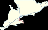
The Queen Elizabeth Way, commonly abbreviated as the QEW, is a 400-Series highway in the Canadian
province of Ontario
. The freeway links Buffalo, New York
and the Niagara Peninsula
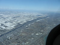
with Toronto
. It begins at the Peace Bridge
in Fort Erie
and travels 139.1 km (86.4 mi) around the western shore of Lake Ontario
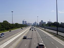
, ending at Highway 427. The physical highway, however, continues as the Gardiner Expressway
into Downtown Toronto
. The QEW is one of Ontario's busiest highways, with close to 200,000 average vehicles per day on some sections. Major highway junctions are located at Highway 420 in Niagara Falls
, Highway 405 and Highway 406 in St. Catharines, the Red Hill Valley Parkway
in Hamilton
, Highway 403 and Highway 407 in Burlington
, Highway 403 at the Oakville
–Mississauga boundary and Highway 427 in Etobicoke. Within the Regional Municipality of Halton, the QEW is signed concurrently
with Highway 403.
The history of the QEW dates back to 1931, when The Middle Road
was widened in a similar fashion to the nearby Highway 5 and Lakeshore Road
as a relief project during the Great Depression
. Following the 1934 provincial election
, Ontario Minister of Highways Thomas McQuesten
and his deputy minister changed this design to be similar to the autobahns of Germany
, dividing the opposite directions of travel and using grade-separated intersections known as interchanges
at major crossroads. When it was completed and opened to traffic in 1937, it was the first intercity divided highway in North America
and featured the longest stretch of consistent illumination in the world. While not a true freeway at the time, it was gradually upgraded, widened and modernized throughout the 1950s and 1960s, more or less taking on its current form by 1970.
of King George VI
. In 1939, the royal couple toured Canada and the United States in part to bolster support for the United Kingdom
in anticipation of war with Nazi Germany
, and also to mark George VI's coronation as king. The highway received its name to commemorate the visit. Originally, the entire length of the highway featured stylized light standards with the letters ER (for Elizabeth Regina, Latin
for "Queen Elizabeth") on them. While mostly removed, they remain in place at three bridges along the route of the highway: in Mississauga over the Credit River
, in Oakville
over Bronte Creek
, and in St. Catharines over Twelve Mile Creek
). A short section of Highway 420 and Roberts Street in Niagara Falls
also has these light standards, as both were the terminus of the QEW prior to the highway being extended to Fort Erie
in the 1950s.
The signs identifying the QEW have always used blue lettering on a yellow background instead of the black-on-white scheme on Ontario's standard King's Highway signs. They originally showed the highway's full name only in small letters, with the large script letters "ER" being where the highway number would go on other signs. In 1955 the lettering was changed to QEW. Trailblazer shields, indicating routes "to QEW," switch the colours to yellow on blue. Ontario’s only other 400-series highway to have had a unique provincial highway shield with letters instead of a number is Highway 401, which was co-designated as the Macdonald-Cartier Freeway.
Because the highway curves sharply around the lakehead of Lake Ontario
, its directions are not signed with cardinal directions as is the case on other Ontario highways, but with destination cities. QEW Toronto is used consistently for the direction toward Toronto. In the other direction, the highway is signed QEW Hamilton from Toronto to Burlington, QEW Niagara from Burlington to Niagara Falls, QEW Fort Erie from Niagara Falls to Fort Erie, and QEW Bridge to USA within Fort Erie.
The QEW is not publicly referred to by any route number, but the MTO has referred to it as both Highway 1 and Highway 451 in annual reports and other internal documents.
, to Toronto, the economic hub of the province. The freeway circles the western lakehead of Lake Ontario, cutting through Niagara Falls, St. Catharines, Hamilton, Burlington, Oakville and Mississauga en route.
 The Queen Elizabeth Way begins at the foot of the Peace Bridge, which connects the freeway with I-190
in Buffalo New York. A customs booth is located between the bridge and the freeway, and provides access to nearby Highway 3
and the Niagara Parkway
, as well as charging a toll to Canada-bound drivers. Through customs, the freeway proper begins, immediately curving northwest. Within the town of Fort Erie, it interchange
s with Central Avenue, Concession Road and Thompson Road, Gilmore Road and Bowen Road. While there is some urban development at the beginning of the freeway, the majority of the first 25 km (15.5 mi) are located within lowland forests. Numerous creeks flow through these forests, often flooding them. The Willoughby marsh Conservation Area lies southwest of the freeway approximately 10 km (6.2 mi) south of Niagara Falls. After an interchange with Lyons Creek Road, the freeway curves northward.
After crossing the Welland River, the original route of the Welland Canal
, the freeway exits the forests and enter agricultural land surrounding the suburbs of Niagara Falls, which the highway enters north of the McLeod Road interchange. Within the city, Highway 420 meets the QEW at a large stack interchange
, which replaced the former Lundy's Lane / Highway 20
interchange.
Exiting the northern fringe of the city, the freeway curves northwest and begins to descend through the Niagara Escarpment
, a World Biosphere Reserve. Highway 405, also known as the General Brock Parkway, merges with the QEW along the short rural stretch between Niagara Falls and St. Catharines. While there is no Toronto-bound access, Niagara-bound drivers can follow Highway 405 to Lewiston, New York
. The QEW continues west into St. Catharines.
to cross the Welland Canal
. The 2.2 km (1.4 mi) structure replaced the lift bridge
located south of it, one of two major bottlenecks during the 1950s.
The QEW is also well known for its vintage highway architecture, which is slowly being replaced as the highway is upgraded through St. Catharines and Niagara Falls. An original 1936 rail overpass at Sandplant Hill in Niagara Falls was slowly removed in 2005 and 2006, and completely replaced in late 2006 (the process was gradual to maintain rail traffic). The 1937-vintage Martindale Road overpass in St. Catharines was similarly replaced in 2008.
 The QEW was called the Middle Road from 1931 to 1939 as a highway connecting Hamilton with Toronto. The QEW formerly continued beyond Highway 427 to the old Toronto city limits at the Humber River; this section was downloaded from provincial to municipal ownership in 1997, and became part of the Gardiner Expressway
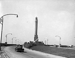
. A monument
was originally located at the highway's Toronto terminus, dedicated to the 1939 visit of King George VI and Queen Elizabeth, and consisted of a column with a crown at the top and a lion at the base. The monument was moved in the mid 1970s in order to accommodate widening of the original QEW, and is now located in the nearby Sir Casimir Gzowski
Park along Lake Ontario, on the east side of the Humber River.
The late-1960s widening project coincided with the construction of the complex interchange with Highway 427 (formerly Highway 27) and resulted in an 8 to 10 lane QEW stretching to the Humber River, with a short collector-express system serving Kipling Avenue
and Islington Avenue. Ramp meter
s were also added to traffic entering the Toronto-bound lanes from Ford Drive to Cawthra Road in 1975. These meters are only activated during the morning rush hour.
The 427–Humber section was downloaded by the province to Toronto in 1997, and was renamed as part of the Gardiner Expressway
, so that the QEW now ends at Highway 427. The section has changed little since then. Since the end of 2003, the conventional truss lighting poles from the late 1960s have been replaced west of Kipling Avenue and east of Royal York Road, in favour of shaded high-mast lighting like that of the Don Valley Parkway
. Bilingual English-French signs were also removed and replaced with English-only signs.
In 2000, the grade-separated traffic circle junction with Erin Mills Parkway and Southdown Road, which dated back to the early 1960s, was completely reconstructed as a standard parclo A4 interchange. The nearby Hurontario Street interchange is currently (2009) being converted from a cloverleaf to a parclo A4 on the south side and a diamond on the north side.
 As automobile use in southern Ontario grew in the early twentieth century, road design and construction advanced significantly. Following frequent erosion of the former macadamized Lake Shore Road,
a cement road known as the Toronto–Hamilton Highway was proposed in January 1914.
The highway was designed to run along the lake shore, instead of Dundas Street
to the north, because the numerous hills encountered along Dundas would have increased costs without improving accessibility. Middle Road, a dirt lane named because of its position between the two, was not considered since Lake Shore and Dundas were both overcrowded and in need of serious repairs.
The road was formally opened on November 24, 1917, 5.5 m (18 ft) wide and nearly 64 km (39.8 mi) long. It was the first concrete road in Ontario, as well as one of the longest stretches of concrete road between two cities in the world.
Over the next decade, vehicle usage increased substantially, and by 1920 Lakeshore Road was again highly congested on weekends.
In response, the Department of Highways examined improving another road between Toronto and Hamilton. The road was to be more than twice the width of Lakeshore Road at 12 m (39.4 ft) and would carry two lanes of traffic in either direction.
Construction on what was then known as the Queen Street Extension west of Toronto began in early 1931.
Before the highway could be completed, Thomas McQuesten
was appointed the new minister of the Department of Highways, with Robert Melville Smith as deputy minister, following the 1934 provincial elections
.
Smith, inspired by the German Autobahn's—new "dual-lane divided highway
s"—modified the design for Ontario roads,
and McQuesten ordered that the Middle Road be converted into this new form of highway.
A 40 m (131.2 ft) right-of-way was purchased along the Middle Road and construction began to convert the existing sections to a divided highway. Work also began on Canada's first interchange
at Highway 10.
McQueston also foresaw the financial opportunities that came with cross-border tourism and opening the "Ontario frontier" to Americans.
One of the first sections of the QEW to be upgraded to a freeway was
from highway 10 (now Hurontario Street) to Dixie Road in what is now Mississauga,
in early 1956. Service roads were installed and 13 intersections eliminated,
and the accident rate was reduced by 50%. The Cawthra interchange was closed on May 1, 1956.
The Queen Elizabeth Way originally ran from Toronto to the Rainbow Bridge
in Niagara Falls. In the 1950s, a second branch was constructed, starting from a traffic circle near Niagara Falls and extending south to Fort Erie
. The original route, now a spur known locally in Niagara Falls as the Queen-E Extension, was still designated as part of the QEW until 1972, when it was reconstructed and redesignated as Highway 420.
In 1958, the original section of the QEW west of Guelph Line was relocated on a new alignment known as the Freeman Diversion which improved access to the proposed Burlington Bay James N. Allan Skyway
and allowed the Freeman Interchange (a "semi-directional T" interchange) to be constructed with the future Highway 403. The old bypassed segment was renamed Plains Road (which was never a freeway and is now a minor arterial road) and the new QEW branched off from it in a Y-junction partial interchange.
High-level bridges were constructed in 1958 (the Burlington Bay James N. Allan Skyway
over Hamilton Harbour in Burlington
) and 1963 (the Garden City Skyway
over the Welland Canal
in St. Catharines
) to allow free movement of traffic without the need to stop for drawbridges. Tolls on these bridges were eventually removed in 1973.
In 1971, two traffic circles in Niagara Falls were removed, where the Queen-E Extension (now Highway 420) met the QEW proper. Motorists at the time, travelling from the QEW proper to the Rainbow Bridge along the Queen-E Extension, would leave one traffic circle and immediately drive through another circle, where the Extension crossed Dorchester Road and the Queenston-Chippawa Hydro Canal. In 1975, another traffic circle on the QEW, with Highway 20
(Centennial Parkway) in Stoney Creek
, was removed in favour of a conventional parclo interchange
.
To meet growing demand, the Burlington Skyway was twinned in 1985. Concurrently, the QEW from Burlington Street
to Lakeshore Boulevard was reconstructed with 8 lanes, a variable lighting system, state-of-the-art changeable message signs and traffic cameras, and modern parclo interchanges with Burlington Street, Northshore Boulevard, and Fairview Street.
In the early to late 1990s, the Freeman Interchange was reconfigured to accommodate Highway 407, and an interchange was added at Brant Street. In 2000–2001, QEW was widened to six lanes from Brant Street to Guelph Line and access to Plains Road was removed. In 2004-2005, the Guelph Line interchange was converted to a standard Parclo A4 configuration.
As part of the Red Hill Valley Parkway
newly opened in 2007, the Burlington Street and Centennial Parkway interchanges were reconstructed, including the construction of collector lanes on the south (Niagara-bound) side of the highway. Construction was completed in 2009.
s on the QEW/403 in the sections from Toronto to St. Catharines
. The highway was recently widened to permit an additional HOV lane in either direction between Guelph Line and Trafalgar Road. These lanes were opened to traffic on November 29, 2010. There are similar plans for the QEW between Red Hill Valley Parkway
and Highway 406.
} (to Niagara Falls, U.S.A.
)
|
|-
|31.5
|32
|
|Signed as exits 32A (east) and 32B (west)
|-
|34.0
|34
|
|
|-
|rowspan="3"|Niagara-on-the-Lake
|36.5
|37
| (to Lewiston, U.S.A.
)
|Niagara-bound exit and Toronto-bound entrance
|-
|37.8
|38
|
|
|-
|colspan="4" rowspan="2"|Garden City Skyway
over the Welland Canal
|-
|rowspan="7"|St. Catharines
|-
|43.9
|44
| / Service Road
|
|-
|45.6
|46
|
|
|-
|46.9
|47
|
|
|-
|47.7
|48
|
|Toronto-bound exit and Niagara-bound entrance
|-
|48.4
|49
|
|
|-
|50.4
|51
|
|
|-
|rowspan="3"|Lincoln
|54.7
|55
|
|
|-
|57.6
|57
|
|
|-
|64.3
|64
|
|
|-
|rowspan="3"|Grimsby
|68.1
|68
|
|
|-
|70.6
|71
| / Maple Avenue / Ontario Street
|
|-
|74.2
|74
|
|
|-
|rowspan="8" colspan="2"|Hamilton
|77.8
|78
|
|
|-
|82.9
|83
|
|
|-
|88.1
|88
|
South Service Road
|Formerly Highway 20
|-
|
|89
|Red Hill Valley Parkway
|
|-
|89.8
|89
|Burlington Street
|
|-
|
|90
|Woodward Avenue
|Niagara-bound exit and Toronto-bound entrance
|-
|93.8
|93
|Eastport Drive (Highway 7189)
|Toronto-bound exit and Niagara-bound entrance
|-
|colspan="4" rowspan="2"|Burlington Bay James N. Allan Skyway
over Burlington Bay
|-
|rowspan="21"|Halton
|rowspan="10"|Burlington
|-
|97.1
|97
|North Shore Boulevard, Eastport Drive
|Formerly Highway 2
|-
|99.5
|99
|Plains Road, Fairview Street
|Toronto-bound exit and Niagara-bound entrance
|-
|rowspan="2"|100.5
|rowspan="2"|100
|
|Toronto-bound exit and Niagara-bound entrance
|-
|, John C. Munro Hamilton International Airport
|Beginning of Highway 403 concurrency
|-
|101.3
|101
|
|Niagara-bound exit and Toronto-bound entrance
|- bgcolor="#ddffdd"
|103.2
|102
|
|
|- bgcolor="#ddffdd"
|105.2
|105
|Walkers Line
|
|- bgcolor="#ddffdd"
|107.3
|107
|
|
|- bgcolor="#ddffdd"
|rowspan="2"|109.3
|rowspan="2"|109
|rowspan="2"|
|rowspan="2"|
|-
|rowspan="11"|Oakville
|- bgcolor="#d3d3d3"
|110.9
|110
|Service Road
|Access removed in 2008 to accommodate widening of the QEW To include HOV Lanes
|- bgcolor="#ddffdd"
|111.3
|111
|
|
|- bgcolor="#ddffdd"
|113.4
|113
|3rd Line
|
|- bgcolor="#ddffdd"
|rowspan="2"|116.5
|rowspan="2"|116
|
|
|- bgcolor="#ddffdd"
|Kerr Street
|Niagara-bound exit only
|- bgcolor="#ddffdd"
|118.6
|118
|
|
|- bgcolor="#ddffdd"
|120.0
|119
|Royal Windsor Drive
|Toronto-bound exit and Niagara-bound entrance; formerly Highway 122
|-
|rowspan="2"|123.1
|rowspan="2"|123
|
|
|-
|
|End of Highway 403 concurrency; Toronto-bound exit and Niagara-bound entrance
|-
|rowspan="2"|124.5
|rowspan="2"|124
|rowspan="2"|
|rowspan="2"|
|-
|rowspan="6"|Peel
|rowspan="6"|Mississauga
|-
|126.6
|126
|
Southdown Road
|Southdown Road formerly Highway 122
|-
|130.7
|130
|Mississauga Road
|
|-
|132.7
|132
|Hurontario Street
|Formerly Highway 10.
|-
|134.9
|134
|
|
|-
|136.7
|136
|
|Niagara-bound exit and Toronto-bound entrance
|-
|rowspan="2" colspan="2"|Toronto
|138.5
|138
|Evans Avenue, West Mall, Brown's Line
|Toronto-bound exit and Niagara-bound entrance
|-
|139.1
|139
| – Pearson Airport
|
|-
|colspan="6"| continues east into downtown Toronto
as the Gardiner Expressway
|- bgcolor="#d3d3d3"
|rowspan="4" colspan="2"|Toronto
|140.5
|140
|Kipling Ave
|rowspan="4"|Redesignated as an extension of the Gardiner Expressway January 1, 1998
|- bgcolor="#d3d3d3"
|141.9
|141
|Islington Ave
|- bgcolor="#d3d3d3"
|143.1
|143
|Park Lawn Rd
|- bgcolor="#d3d3d3"
|145.3
|145
|
Canada
Canada is a North American country consisting of ten provinces and three territories. Located in the northern part of the continent, it extends from the Atlantic Ocean in the east to the Pacific Ocean in the west, and northward into the Arctic Ocean...
province of Ontario
Ontario
Ontario is a province of Canada, located in east-central Canada. It is Canada's most populous province and second largest in total area. It is home to the nation's most populous city, Toronto, and the nation's capital, Ottawa....
. The freeway links Buffalo, New York
Buffalo, New York
Buffalo is the second most populous city in the state of New York, after New York City. Located in Western New York on the eastern shores of Lake Erie and at the head of the Niagara River across from Fort Erie, Ontario, Buffalo is the seat of Erie County and the principal city of the...
and the Niagara Peninsula
Niagara Peninsula
The Niagara Peninsula is the portion of Southern Ontario, Canada lying between the south shore of Lake Ontario and the north shore of Lake Erie. It stretches from the Niagara River in the east to Hamilton, Ontario in the west. The population of the peninsula is roughly 1,000,000 people...
with Toronto
Toronto
Toronto is the provincial capital of Ontario and the largest city in Canada. It is located in Southern Ontario on the northwestern shore of Lake Ontario. A relatively modern city, Toronto's history dates back to the late-18th century, when its land was first purchased by the British monarchy from...
. It begins at the Peace Bridge
Peace Bridge
The Peace Bridge is an international bridge between Canada and the United States at the east end of Lake Erie at the source of the Niagara River, about upriver of Niagara Falls. It connects the City of Buffalo, New York, in the United States to the Town of Fort Erie, Ontario, in Canada...
in Fort Erie
Fort Erie, Ontario
Fort Erie is a town on the Niagara River in the Niagara Region, Ontario, Canada. It is located directly across the river from Buffalo, New York....
and travels 139.1 km (86.4 mi) around the western shore of Lake Ontario
Lake Ontario
Lake Ontario is one of the five Great Lakes of North America. It is bounded on the north and southwest by the Canadian province of Ontario, and on the south by the American state of New York. Ontario, Canada's most populous province, was named for the lake. In the Wyandot language, ontarío means...
, ending at Highway 427. The physical highway, however, continues as the Gardiner Expressway
Gardiner Expressway
The Frederick G. Gardiner Expressway, colloquially referred to as "the Gardiner", is a municipal expressway in the Canadian province of Ontario, connecting downtown Toronto with its western suburbs...
into Downtown Toronto
Downtown Toronto
Downtown Toronto is the central business district of Toronto, Ontario, Canada. It is approximately bounded by Bloor Street to the north, Lake Ontario to the south, the Don River to the east, and Bathurst Street to the west...
. The QEW is one of Ontario's busiest highways, with close to 200,000 average vehicles per day on some sections. Major highway junctions are located at Highway 420 in Niagara Falls
Niagara Falls, Ontario
Niagara Falls is a Canadian city on the Niagara River in the Golden Horseshoe region of Southern Ontario. The municipality was incorporated on June 12, 1903...
, Highway 405 and Highway 406 in St. Catharines, the Red Hill Valley Parkway
Red Hill Valley Parkway
The Red Hill Valley Parkway , referred to as the Red Hill Creek Expressway during planning is a municipal expressway in the Canadian city of Hamilton, Ontario. The route connects the Lincoln M. Alexander Parkway, Hamilton's second municipal expressway, to the Queen Elizabeth Way near Hamilton...
in Hamilton
Hamilton, Ontario
Hamilton is a port city in the Canadian province of Ontario. Conceived by George Hamilton when he purchased the Durand farm shortly after the War of 1812, Hamilton has become the centre of a densely populated and industrialized region at the west end of Lake Ontario known as the Golden Horseshoe...
, Highway 403 and Highway 407 in Burlington
Burlington, Ontario
Burlington , is a city located in Halton Region at the western end of Lake Ontario. Burlington is part of the Greater Toronto Area, and is also included in the Hamilton Census Metropolitan Area. Physically, Burlington lies between the north shore of Lake Ontario and the Niagara Escarpment...
, Highway 403 at the Oakville
Oakville, Ontario
Oakville is a town in Halton Region, on Lake Ontario in Southern Ontario, Canada, and is part of the Greater Toronto Area. As of the 2006 census the population was 165,613.-History:In 1793, Dundas Street was surveyed for a military road...
–Mississauga boundary and Highway 427 in Etobicoke. Within the Regional Municipality of Halton, the QEW is signed concurrently
Concurrency (road)
A concurrency, overlap, or coincidence in a road network is an instance of one physical road bearing two or more different highway, motorway, or other route numbers...
with Highway 403.
The history of the QEW dates back to 1931, when The Middle Road
The Middle Road
The Middle Road was the name for a historic highway in the Canadian province of Ontario, which served to link the cities of Toronto and Hamilton...
was widened in a similar fashion to the nearby Highway 5 and Lakeshore Road
Lakeshore Road
Lakeshore Road is an arterial road that follows the northern shoreline of Lake Ontario between the cities of Toronto and Hamilton in the Canadian province of Ontario. In 1917 it became the longest intercity stretch of concrete road in the world upon its completion, as well as the first concrete...
as a relief project during the Great Depression
Great Depression
The Great Depression was a severe worldwide economic depression in the decade preceding World War II. The timing of the Great Depression varied across nations, but in most countries it started in about 1929 and lasted until the late 1930s or early 1940s...
. Following the 1934 provincial election
Ontario general election, 1934
The Ontario general election, 1934 was the 19th general election held in the Province of Ontario, Canada. It was held on June 19, 1934, to elect the 90 Members of the 19th Legislative Assembly of Ontario ....
, Ontario Minister of Highways Thomas McQuesten
Thomas McQuesten
Thomas Baker McQuesten was a Canadian athlete, militiaman, lawyer, politician and government appointee who lived in Hamilton, Ontario....
and his deputy minister changed this design to be similar to the autobahns of Germany
Germany
Germany , officially the Federal Republic of Germany , is a federal parliamentary republic in Europe. The country consists of 16 states while the capital and largest city is Berlin. Germany covers an area of 357,021 km2 and has a largely temperate seasonal climate...
, dividing the opposite directions of travel and using grade-separated intersections known as interchanges
Interchange (road)
In the field of road transport, an interchange is a road junction that typically uses grade separation, and one or more ramps, to permit traffic on at least one highway to pass through the junction without directly crossing any other traffic stream. It differs from a standard intersection, at which...
at major crossroads. When it was completed and opened to traffic in 1937, it was the first intercity divided highway in North America
North America
North America is a continent wholly within the Northern Hemisphere and almost wholly within the Western Hemisphere. It is also considered a northern subcontinent of the Americas...
and featured the longest stretch of consistent illumination in the world. While not a true freeway at the time, it was gradually upgraded, widened and modernized throughout the 1950s and 1960s, more or less taking on its current form by 1970.
Name and signage
The Queen Elizabeth Way was named for Queen Elizabeth (later known as the "Queen Mother"), the Queen ConsortQueen consort
A queen consort is the wife of a reigning king. A queen consort usually shares her husband's rank and holds the feminine equivalent of the king's monarchical titles. Historically, queens consort do not share the king regnant's political and military powers. Most queens in history were queens consort...
of King George VI
George VI of the United Kingdom
George VI was King of the United Kingdom and the Dominions of the British Commonwealth from 11 December 1936 until his death...
. In 1939, the royal couple toured Canada and the United States in part to bolster support for the United Kingdom
United Kingdom
The United Kingdom of Great Britain and Northern IrelandIn the United Kingdom and Dependencies, other languages have been officially recognised as legitimate autochthonous languages under the European Charter for Regional or Minority Languages...
in anticipation of war with Nazi Germany
Nazi Germany
Nazi Germany , also known as the Third Reich , but officially called German Reich from 1933 to 1943 and Greater German Reich from 26 June 1943 onward, is the name commonly used to refer to the state of Germany from 1933 to 1945, when it was a totalitarian dictatorship ruled by...
, and also to mark George VI's coronation as king. The highway received its name to commemorate the visit. Originally, the entire length of the highway featured stylized light standards with the letters ER (for Elizabeth Regina, Latin
Latin
Latin is an Italic language originally spoken in Latium and Ancient Rome. It, along with most European languages, is a descendant of the ancient Proto-Indo-European language. Although it is considered a dead language, a number of scholars and members of the Christian clergy speak it fluently, and...
for "Queen Elizabeth") on them. While mostly removed, they remain in place at three bridges along the route of the highway: in Mississauga over the Credit River
Credit River
The Credit River is a river in southern Ontario which flows from headwaters above the Niagara Escarpment to empty into Lake Ontario at Port Credit, Mississauga. It drains an area of approximately 1,000 km²...
, in Oakville
Oakville, Ontario
Oakville is a town in Halton Region, on Lake Ontario in Southern Ontario, Canada, and is part of the Greater Toronto Area. As of the 2006 census the population was 165,613.-History:In 1793, Dundas Street was surveyed for a military road...
over Bronte Creek
Bronte Creek
Bronte Creek is a waterway in the Lake Ontario watershed of Ontario Canada. It runs through Hamilton and Halton Region, with its source in the Niagara Escarpment, passing Bronte Creek Provincial Park, on its way to Lake Ontario at Bronte Harbour in Oakville, where the creek is also known as Twelve...
, and in St. Catharines over Twelve Mile Creek
Twelve Mile Creek (Ontario)
Twelve Mile Creek is a waterway located in the Niagara Peninsula of Ontario, Canada. Its headwaters are located in the town of Pelham, Ontario, encompassing some of the most unspoiled and natural areas of Niagara area. Its lower reaches flow through urban areas of Thorold, Ontario and St...
). A short section of Highway 420 and Roberts Street in Niagara Falls
Niagara Falls, Ontario
Niagara Falls is a Canadian city on the Niagara River in the Golden Horseshoe region of Southern Ontario. The municipality was incorporated on June 12, 1903...
also has these light standards, as both were the terminus of the QEW prior to the highway being extended to Fort Erie
Fort Erie, Ontario
Fort Erie is a town on the Niagara River in the Niagara Region, Ontario, Canada. It is located directly across the river from Buffalo, New York....
in the 1950s.
The signs identifying the QEW have always used blue lettering on a yellow background instead of the black-on-white scheme on Ontario's standard King's Highway signs. They originally showed the highway's full name only in small letters, with the large script letters "ER" being where the highway number would go on other signs. In 1955 the lettering was changed to QEW. Trailblazer shields, indicating routes "to QEW," switch the colours to yellow on blue. Ontario’s only other 400-series highway to have had a unique provincial highway shield with letters instead of a number is Highway 401, which was co-designated as the Macdonald-Cartier Freeway.
Because the highway curves sharply around the lakehead of Lake Ontario
Lake Ontario
Lake Ontario is one of the five Great Lakes of North America. It is bounded on the north and southwest by the Canadian province of Ontario, and on the south by the American state of New York. Ontario, Canada's most populous province, was named for the lake. In the Wyandot language, ontarío means...
, its directions are not signed with cardinal directions as is the case on other Ontario highways, but with destination cities. QEW Toronto is used consistently for the direction toward Toronto. In the other direction, the highway is signed QEW Hamilton from Toronto to Burlington, QEW Niagara from Burlington to Niagara Falls, QEW Fort Erie from Niagara Falls to Fort Erie, and QEW Bridge to USA within Fort Erie.
The QEW is not publicly referred to by any route number, but the MTO has referred to it as both Highway 1 and Highway 451 in annual reports and other internal documents.
Route description
The QEW is a 139 kilometres (86.4 mi) route which travels from the Peace Bridge, connecting Fort Erie with Buffalo, New YorkNew York
New York is a state in the Northeastern region of the United States. It is the nation's third most populous state. New York is bordered by New Jersey and Pennsylvania to the south, and by Connecticut, Massachusetts and Vermont to the east...
, to Toronto, the economic hub of the province. The freeway circles the western lakehead of Lake Ontario, cutting through Niagara Falls, St. Catharines, Hamilton, Burlington, Oakville and Mississauga en route.
Fort Erie – St. Catharines
Interstate 190 (New York)
Interstate 190 runs 28.34 miles from Interstate 90 near Buffalo, New York to Lewiston, New York via Niagara Falls. Parts of this highway were built on the former rights-of-way of the Lehigh Valley Railroad and the Erie Canal. It is referred to by locals as The One-Ninety...
in Buffalo New York. A customs booth is located between the bridge and the freeway, and provides access to nearby Highway 3
Ontario Highway 3
King's Highway 3, commonly referred to as Highway 3 and historically as the Talbot Trail, is a provincially maintained highway in the Canadian province of Ontario which travels parallel to the shore of Lake Erie. It has three segments, the first of which runs from the Ambassador Bridge in Windsor...
and the Niagara Parkway
Niagara Parkway
The Niagara Parkway, formerly known as Niagara Boulevard and historically as the Niagara Road, is a scenic road in the province of Ontario that travels on the Canadian side of the Niagara River from the town of Fort Erie to Niagara-on-the-Lake...
, as well as charging a toll to Canada-bound drivers. Through customs, the freeway proper begins, immediately curving northwest. Within the town of Fort Erie, it interchange
Interchange (road)
In the field of road transport, an interchange is a road junction that typically uses grade separation, and one or more ramps, to permit traffic on at least one highway to pass through the junction without directly crossing any other traffic stream. It differs from a standard intersection, at which...
s with Central Avenue, Concession Road and Thompson Road, Gilmore Road and Bowen Road. While there is some urban development at the beginning of the freeway, the majority of the first 25 km (15.5 mi) are located within lowland forests. Numerous creeks flow through these forests, often flooding them. The Willoughby marsh Conservation Area lies southwest of the freeway approximately 10 km (6.2 mi) south of Niagara Falls. After an interchange with Lyons Creek Road, the freeway curves northward.
After crossing the Welland River, the original route of the Welland Canal
First Welland Canal
The Welland Canal has gone through many incarnations in its history. Today, five distinct canal-construction efforts are recognized. The retronym First Welland Canal is applied to the original canal, constructed from 1824 to 1829 and 1831 to 1833....
, the freeway exits the forests and enter agricultural land surrounding the suburbs of Niagara Falls, which the highway enters north of the McLeod Road interchange. Within the city, Highway 420 meets the QEW at a large stack interchange
Stack interchange
A stack interchange is a free-flowing grade separated junction between two roads.In countries where one drives on the right, left turns are handled by semi-directional flyover/under ramps...
, which replaced the former Lundy's Lane / Highway 20
Ontario Highway 20
King's Highway 20, also known as Highway 20, is a provincially maintained highway in the Canadian province of Ontario. Presently, it is a short stub between Highway 58 and Niagara Regional Road 70 in the town of Thorold.- History :...
interchange.
Exiting the northern fringe of the city, the freeway curves northwest and begins to descend through the Niagara Escarpment
Niagara Escarpment
The Niagara Escarpment is a long escarpment, or cuesta, in the United States and Canada that runs westward from New York State, through Ontario, Michigan, Wisconsin and Illinois...
, a World Biosphere Reserve. Highway 405, also known as the General Brock Parkway, merges with the QEW along the short rural stretch between Niagara Falls and St. Catharines. While there is no Toronto-bound access, Niagara-bound drivers can follow Highway 405 to Lewiston, New York
Lewiston, New York
Lewiston is a village in Niagara County, New York, United States. The population was 2,781 at the 2000 census. The village is named after Morgan Lewis, an early 19th-century governor of New York. It is part of the Buffalo–Niagara Falls Metropolitan Statistical Area.The Village of Lewiston,...
. The QEW continues west into St. Catharines.
St. Catharines – Burlington
As the Queen Elizabeth Way enters St. Catharines, it ascends onto the Garden City SkywayGarden City Skyway
The Garden City Skyway is a major high-level bridge located in St. Catharines and Niagara-on-the-Lake, Ontario, Canada, that allows the Queen Elizabeth Way to cross the Welland Canal without the interruption of a lift bridge. Six lanes of traffic are carried across the bridge, which is 2.2km in...
to cross the Welland Canal
Welland Canal
The Welland Canal is a ship canal in Canada that extends from Port Weller, Ontario, on Lake Ontario, to Port Colborne, Ontario, on Lake Erie. As a part of the St...
. The 2.2 km (1.4 mi) structure replaced the lift bridge
Lift bridge
A vertical-lift bridge or lift bridge is a type of movable bridge in which a span rises vertically while remaining parallel with the deck....
located south of it, one of two major bottlenecks during the 1950s.
The QEW is also well known for its vintage highway architecture, which is slowly being replaced as the highway is upgraded through St. Catharines and Niagara Falls. An original 1936 rail overpass at Sandplant Hill in Niagara Falls was slowly removed in 2005 and 2006, and completely replaced in late 2006 (the process was gradual to maintain rail traffic). The 1937-vintage Martindale Road overpass in St. Catharines was similarly replaced in 2008.
Burlington–Toronto
Gardiner Expressway
The Frederick G. Gardiner Expressway, colloquially referred to as "the Gardiner", is a municipal expressway in the Canadian province of Ontario, connecting downtown Toronto with its western suburbs...
. A monument
Queen Elizabeth Way Monument
The Queen Elizabeth Way Monument, also known as the Lion Monument and as the Loring Lion, is a memorial originally located at the Toronto end of the Queen Elizabeth Way . The monument was designed by architect W.I...
was originally located at the highway's Toronto terminus, dedicated to the 1939 visit of King George VI and Queen Elizabeth, and consisted of a column with a crown at the top and a lion at the base. The monument was moved in the mid 1970s in order to accommodate widening of the original QEW, and is now located in the nearby Sir Casimir Gzowski
Casimir Gzowski
Sir Kazimierz Stanislaus Gzowski, KCMG , was an engineer who served as acting Lieutenant Governor of Ontario from 1896 to 1897....
Park along Lake Ontario, on the east side of the Humber River.
The late-1960s widening project coincided with the construction of the complex interchange with Highway 427 (formerly Highway 27) and resulted in an 8 to 10 lane QEW stretching to the Humber River, with a short collector-express system serving Kipling Avenue
Kipling Avenue
Kipling Avenue, originally named Mimico Avenue, is a street in the Etobicoke district of Toronto, Ontario, Canada. It is a concession road, 6 concessions from Yonge Street, and is a major north–south arterial road that also extends beyond Toronto, into the Regional Municipality of York.The...
and Islington Avenue. Ramp meter
Ramp meter
A ramp meter, ramp signal or metering light is a device, usually a basic traffic light or a two-section signal light together with a signal controller, that regulates the flow of traffic entering freeways according to current traffic conditions...
s were also added to traffic entering the Toronto-bound lanes from Ford Drive to Cawthra Road in 1975. These meters are only activated during the morning rush hour.
The 427–Humber section was downloaded by the province to Toronto in 1997, and was renamed as part of the Gardiner Expressway
Gardiner Expressway
The Frederick G. Gardiner Expressway, colloquially referred to as "the Gardiner", is a municipal expressway in the Canadian province of Ontario, connecting downtown Toronto with its western suburbs...
, so that the QEW now ends at Highway 427. The section has changed little since then. Since the end of 2003, the conventional truss lighting poles from the late 1960s have been replaced west of Kipling Avenue and east of Royal York Road, in favour of shaded high-mast lighting like that of the Don Valley Parkway
Don Valley Parkway
The Don Valley Parkway is a controlled-access six-lane municipal expressway in Toronto connecting the Gardiner Expressway in downtown Toronto with Ontario Highway 401, the Macdonald–Cartier Freeway. North of Highway 401, it continues as Ontario Highway 404. The parkway runs through...
. Bilingual English-French signs were also removed and replaced with English-only signs.
In 2000, the grade-separated traffic circle junction with Erin Mills Parkway and Southdown Road, which dated back to the early 1960s, was completely reconstructed as a standard parclo A4 interchange. The nearby Hurontario Street interchange is currently (2009) being converted from a cloverleaf to a parclo A4 on the south side and a diamond on the north side.
History
a cement road known as the Toronto–Hamilton Highway was proposed in January 1914.
The highway was designed to run along the lake shore, instead of Dundas Street
Dundas Street (Toronto)
Dundas Street, also known as Highway 5 west of Toronto, is a major arterial road connecting the centre of that city with its western suburbs and southwestern Ontario beyond...
to the north, because the numerous hills encountered along Dundas would have increased costs without improving accessibility. Middle Road, a dirt lane named because of its position between the two, was not considered since Lake Shore and Dundas were both overcrowded and in need of serious repairs.
The road was formally opened on November 24, 1917, 5.5 m (18 ft) wide and nearly 64 km (39.8 mi) long. It was the first concrete road in Ontario, as well as one of the longest stretches of concrete road between two cities in the world.
Over the next decade, vehicle usage increased substantially, and by 1920 Lakeshore Road was again highly congested on weekends.
In response, the Department of Highways examined improving another road between Toronto and Hamilton. The road was to be more than twice the width of Lakeshore Road at 12 m (39.4 ft) and would carry two lanes of traffic in either direction.
Construction on what was then known as the Queen Street Extension west of Toronto began in early 1931.
Before the highway could be completed, Thomas McQuesten
Thomas McQuesten
Thomas Baker McQuesten was a Canadian athlete, militiaman, lawyer, politician and government appointee who lived in Hamilton, Ontario....
was appointed the new minister of the Department of Highways, with Robert Melville Smith as deputy minister, following the 1934 provincial elections
Ontario general election, 1934
The Ontario general election, 1934 was the 19th general election held in the Province of Ontario, Canada. It was held on June 19, 1934, to elect the 90 Members of the 19th Legislative Assembly of Ontario ....
.
Smith, inspired by the German Autobahn's—new "dual-lane divided highway
Divided Highway
Divided Highway is a compilation album by American rock band The Doobie Brothers, released in 2003. . All tracks are taken from the albums Cycles and Brotherhood .-Track listing:...
s"—modified the design for Ontario roads,
and McQuesten ordered that the Middle Road be converted into this new form of highway.
A 40 m (131.2 ft) right-of-way was purchased along the Middle Road and construction began to convert the existing sections to a divided highway. Work also began on Canada's first interchange
Interchange (road)
In the field of road transport, an interchange is a road junction that typically uses grade separation, and one or more ramps, to permit traffic on at least one highway to pass through the junction without directly crossing any other traffic stream. It differs from a standard intersection, at which...
at Highway 10.
McQueston also foresaw the financial opportunities that came with cross-border tourism and opening the "Ontario frontier" to Americans.
One of the first sections of the QEW to be upgraded to a freeway was
from highway 10 (now Hurontario Street) to Dixie Road in what is now Mississauga,
in early 1956. Service roads were installed and 13 intersections eliminated,
and the accident rate was reduced by 50%. The Cawthra interchange was closed on May 1, 1956.
The Queen Elizabeth Way originally ran from Toronto to the Rainbow Bridge
Rainbow Bridge (Niagara Falls)
The Rainbow Bridge at Niagara Falls is an international steel arch bridge across the Niagara River gorge, and is a world-famous tourist site. It connects the cities of Niagara Falls, New York, United States , and Niagara Falls, Ontario, Canada .-Construction:The Rainbow Bridge was built near the...
in Niagara Falls. In the 1950s, a second branch was constructed, starting from a traffic circle near Niagara Falls and extending south to Fort Erie
Fort Erie, Ontario
Fort Erie is a town on the Niagara River in the Niagara Region, Ontario, Canada. It is located directly across the river from Buffalo, New York....
. The original route, now a spur known locally in Niagara Falls as the Queen-E Extension, was still designated as part of the QEW until 1972, when it was reconstructed and redesignated as Highway 420.
In 1958, the original section of the QEW west of Guelph Line was relocated on a new alignment known as the Freeman Diversion which improved access to the proposed Burlington Bay James N. Allan Skyway
Burlington Bay James N. Allan Skyway
The Burlington Bay James N. Allan Skyway, originally called the Burlington Bay Skyway, is a pair of high-level freeway bridges located in Hamilton and Burlington, Ontario, Canada...
and allowed the Freeman Interchange (a "semi-directional T" interchange) to be constructed with the future Highway 403. The old bypassed segment was renamed Plains Road (which was never a freeway and is now a minor arterial road) and the new QEW branched off from it in a Y-junction partial interchange.
High-level bridges were constructed in 1958 (the Burlington Bay James N. Allan Skyway
Burlington Bay James N. Allan Skyway
The Burlington Bay James N. Allan Skyway, originally called the Burlington Bay Skyway, is a pair of high-level freeway bridges located in Hamilton and Burlington, Ontario, Canada...
over Hamilton Harbour in Burlington
Burlington, Ontario
Burlington , is a city located in Halton Region at the western end of Lake Ontario. Burlington is part of the Greater Toronto Area, and is also included in the Hamilton Census Metropolitan Area. Physically, Burlington lies between the north shore of Lake Ontario and the Niagara Escarpment...
) and 1963 (the Garden City Skyway
Garden City Skyway
The Garden City Skyway is a major high-level bridge located in St. Catharines and Niagara-on-the-Lake, Ontario, Canada, that allows the Queen Elizabeth Way to cross the Welland Canal without the interruption of a lift bridge. Six lanes of traffic are carried across the bridge, which is 2.2km in...
over the Welland Canal
Welland Canal
The Welland Canal is a ship canal in Canada that extends from Port Weller, Ontario, on Lake Ontario, to Port Colborne, Ontario, on Lake Erie. As a part of the St...
in St. Catharines
St. Catharines, Ontario
St. Catharines is the largest city in Canada's Niagara Region and the sixth largest urban area in Ontario, Canada, with 97.11 square kilometres of land...
) to allow free movement of traffic without the need to stop for drawbridges. Tolls on these bridges were eventually removed in 1973.
In 1971, two traffic circles in Niagara Falls were removed, where the Queen-E Extension (now Highway 420) met the QEW proper. Motorists at the time, travelling from the QEW proper to the Rainbow Bridge along the Queen-E Extension, would leave one traffic circle and immediately drive through another circle, where the Extension crossed Dorchester Road and the Queenston-Chippawa Hydro Canal. In 1975, another traffic circle on the QEW, with Highway 20
Highway 20 (Ontario)
King's Highway 20, also known as Highway 20, is a provincially maintained highway in the Canadian province of Ontario. Presently, it is a short stub between Highway 58 and Niagara Regional Road 70 in the town of Thorold.- History :...
(Centennial Parkway) in Stoney Creek
Stoney Creek, Ontario
Stoney Creek is a community in Ontario, Canada.Note: This article will only deal with matters up to its amalgamation with Hamilton.-Geography and population:...
, was removed in favour of a conventional parclo interchange
Parclo interchange
A partial cloverleaf interchange or parclo is a modification of a cloverleaf interchange. The parclo interchange was developed by the Ontario Ministry of Transportation as a replacement for the cloverleaf on 400-Series Highways, removing the dangerous weaving patterns and allowing for more...
.
To meet growing demand, the Burlington Skyway was twinned in 1985. Concurrently, the QEW from Burlington Street
Burlington Street
Burlington Street is a road in Hamilton, Ontario, stretching along the south shore of Hamilton Harbour in Lake Ontario. Burlington Street has four different statuses along the route. In its western terminus, it is a collector route ending at Bay Street North...
to Lakeshore Boulevard was reconstructed with 8 lanes, a variable lighting system, state-of-the-art changeable message signs and traffic cameras, and modern parclo interchanges with Burlington Street, Northshore Boulevard, and Fairview Street.
In the early to late 1990s, the Freeman Interchange was reconfigured to accommodate Highway 407, and an interchange was added at Brant Street. In 2000–2001, QEW was widened to six lanes from Brant Street to Guelph Line and access to Plains Road was removed. In 2004-2005, the Guelph Line interchange was converted to a standard Parclo A4 configuration.
As part of the Red Hill Valley Parkway
Red Hill Valley Parkway
The Red Hill Valley Parkway , referred to as the Red Hill Creek Expressway during planning is a municipal expressway in the Canadian city of Hamilton, Ontario. The route connects the Lincoln M. Alexander Parkway, Hamilton's second municipal expressway, to the Queen Elizabeth Way near Hamilton...
newly opened in 2007, the Burlington Street and Centennial Parkway interchanges were reconstructed, including the construction of collector lanes on the south (Niagara-bound) side of the highway. Construction was completed in 2009.
Future
The Ministry's future plans are to add High-occupancy vehicle laneHigh-occupancy vehicle lane
In transportation engineering and transportation planning, a high-occupancy vehicle lane is a lane reserved for vehicles with a driver and one or more passengers...
s on the QEW/403 in the sections from Toronto to St. Catharines
St. Catharines, Ontario
St. Catharines is the largest city in Canada's Niagara Region and the sixth largest urban area in Ontario, Canada, with 97.11 square kilometres of land...
. The highway was recently widened to permit an additional HOV lane in either direction between Guelph Line and Trafalgar Road. These lanes were opened to traffic on November 29, 2010. There are similar plans for the QEW between Red Hill Valley Parkway
Red Hill Valley Parkway
The Red Hill Valley Parkway , referred to as the Red Hill Creek Expressway during planning is a municipal expressway in the Canadian city of Hamilton, Ontario. The route connects the Lincoln M. Alexander Parkway, Hamilton's second municipal expressway, to the Queen Elizabeth Way near Hamilton...
and Highway 406.
Exit list
The following table lists the exits along the QEW. Exits are numbered from Fort Erie to Toronto.| Division | Location | km | Exit Exit number An exit number is a number assigned to a road junction, usually an exit from a freeway. It is usually marked on the same sign as the destinations of the exit, as well as a sign in the gore.... |
Destinations | Notes |
|---|---|---|---|---|---|
Peace Bridge The Peace Bridge is an international bridge between Canada and the United States at the east end of Lake Erie at the source of the Niagara River, about upriver of Niagara Falls. It connects the City of Buffalo, New York, in the United States to the Town of Fort Erie, Ontario, in Canada... over the Niagara River Niagara River The Niagara River flows north from Lake Erie to Lake Ontario. It forms part of the border between the Province of Ontario in Canada and New York State in the United States. There are differing theories as to the origin of the name of the river... |
|||||
| Niagara | Fort Erie Fort Erie, Ontario Fort Erie is a town on the Niagara River in the Niagara Region, Ontario, Canada. It is located directly across the river from Buffalo, New York.... |
0.2 | International customs plaza; no exit number; no access from Central Avenue to Peace Bridge. Toll rates | ||
| 1.1 | 1 | Toronto-bound exit and Fort Erie -bound entrance | |||
| 2.1 | 2 | to | Toronto-bound exit and Fort Erie -bound entrance | ||
| Fort Erie -bound exit and Toronto-bound entrance | |||||
| 4.6 | 5 | ||||
| 6.7 | 7 | ||||
| 12.2 | 12 | ||||
| Niagara Falls Niagara Falls, Ontario Niagara Falls is a Canadian city on the Niagara River in the Golden Horseshoe region of Southern Ontario. The municipality was incorporated on June 12, 1903... |
|||||
| 15.5 | 16 | ||||
| 22.1 | 21 | ||||
| 26.6 | 27 | ||||
| 29.5 | 30 | ||||
Niagara Falls, New York
Niagara Falls is a city in Niagara County, New York, United States. As of the 2010 census, the city had a total population of 50,193, down from the 55,593 recorded in the 2000 census. It is across the Niagara River from Niagara Falls, Ontario , both named after the famed Niagara Falls which they...
)
|
|-
|31.5
|32
|
|Signed as exits 32A (east) and 32B (west)
|-
|34.0
|34
|
|
|-
|rowspan="3"|Niagara-on-the-Lake
Niagara-on-the-Lake
Niagara-on-the-Lake is a Canadian town located in Southern Ontario where the Niagara River meets Lake Ontario in the Niagara Region of the southern part of the province of Ontario. It is located across the Niagara river from Youngstown, New York, USA...
|36.5
|37
| (to Lewiston, U.S.A.
Lewiston, New York
Lewiston is a village in Niagara County, New York, United States. The population was 2,781 at the 2000 census. The village is named after Morgan Lewis, an early 19th-century governor of New York. It is part of the Buffalo–Niagara Falls Metropolitan Statistical Area.The Village of Lewiston,...
)
|Niagara-bound exit and Toronto-bound entrance
|-
|37.8
|38
|
|
|-
|colspan="4" rowspan="2"|
Garden City Skyway
The Garden City Skyway is a major high-level bridge located in St. Catharines and Niagara-on-the-Lake, Ontario, Canada, that allows the Queen Elizabeth Way to cross the Welland Canal without the interruption of a lift bridge. Six lanes of traffic are carried across the bridge, which is 2.2km in...
over the Welland Canal
Welland Canal
The Welland Canal is a ship canal in Canada that extends from Port Weller, Ontario, on Lake Ontario, to Port Colborne, Ontario, on Lake Erie. As a part of the St...
|-
|rowspan="7"|St. Catharines
|-
|43.9
|44
| / Service Road
|
|-
|45.6
|46
|
|
|-
|46.9
|47
|
|
|-
|47.7
|48
|
|Toronto-bound exit and Niagara-bound entrance
|-
|48.4
|49
|
|
|-
|50.4
|51
|
|
|-
|rowspan="3"|Lincoln
Lincoln, Ontario
Lincoln is a town on Lake Ontario in the Niagara Region, Ontario, Canada. The town's administrative and commercial centre is in the community of Beamsville.-Geography:...
|54.7
|55
|
|
|-
|57.6
|57
|
|
|-
|64.3
|64
|
|
|-
|rowspan="3"|Grimsby
Grimsby, Ontario
Grimsby is a town on Lake Ontario in the Niagara Region, Ontario, Canada. Grimsby is a part of the Hamilton Census Metropolitan Area. The majority of residents reside in the area bounded by Lake Ontario and the Niagara escarpment...
|68.1
|68
|
|
|-
|70.6
|71
| / Maple Avenue / Ontario Street
|
|-
|74.2
|74
|
|
|-
|rowspan="8" colspan="2"|Hamilton
Hamilton, Ontario
Hamilton is a port city in the Canadian province of Ontario. Conceived by George Hamilton when he purchased the Durand farm shortly after the War of 1812, Hamilton has become the centre of a densely populated and industrialized region at the west end of Lake Ontario known as the Golden Horseshoe...
|77.8
|78
|
|
|-
|82.9
|83
|
|
|-
|88.1
|88
|
South Service Road
|Formerly Highway 20
|-
|
|89
|Red Hill Valley Parkway
Red Hill Valley Parkway
The Red Hill Valley Parkway , referred to as the Red Hill Creek Expressway during planning is a municipal expressway in the Canadian city of Hamilton, Ontario. The route connects the Lincoln M. Alexander Parkway, Hamilton's second municipal expressway, to the Queen Elizabeth Way near Hamilton...
|
|-
|89.8
|89
|Burlington Street
|
|-
|
|90
|Woodward Avenue
|Niagara-bound exit and Toronto-bound entrance
|-
|93.8
|93
|Eastport Drive (Highway 7189)
|Toronto-bound exit and Niagara-bound entrance
|-
|colspan="4" rowspan="2"|
Burlington Bay James N. Allan Skyway
The Burlington Bay James N. Allan Skyway, originally called the Burlington Bay Skyway, is a pair of high-level freeway bridges located in Hamilton and Burlington, Ontario, Canada...
over Burlington Bay
Burlington Bay
Burlington Bay, known more commonly as Hamilton Harbour, lies on the western tip of Lake Ontario, bounded on the northwest by the City of Burlington, on the south by the City of Hamilton, and on the east by Hamilton Beach and Burlington Beach...
|-
|rowspan="21"|Halton
|rowspan="10"|Burlington
Burlington, Ontario
Burlington , is a city located in Halton Region at the western end of Lake Ontario. Burlington is part of the Greater Toronto Area, and is also included in the Hamilton Census Metropolitan Area. Physically, Burlington lies between the north shore of Lake Ontario and the Niagara Escarpment...
|-
|97.1
|97
|North Shore Boulevard, Eastport Drive
|Formerly Highway 2
Ontario Highway 2
King's Highway 2, usually referred to simply as Highway 2 is a provincially maintained highway in Ontario. Once the primary east–west route across the southern end of the province, Highway 2 became mostly redundant in the 1960s following the completion of Highway 401, which more or less...
|-
|99.5
|99
|Plains Road, Fairview Street
|Toronto-bound exit and Niagara-bound entrance
|-
|rowspan="2"|100.5
|rowspan="2"|100
|
|Toronto-bound exit and Niagara-bound entrance
|-
|, John C. Munro Hamilton International Airport
|Beginning of Highway 403 concurrency
|-
|101.3
|101
|
|Niagara-bound exit and Toronto-bound entrance
|- bgcolor="#ddffdd"
|103.2
|102
|
|
|- bgcolor="#ddffdd"
|105.2
|105
|Walkers Line
|
|- bgcolor="#ddffdd"
|107.3
|107
|
|
|- bgcolor="#ddffdd"
|rowspan="2"|109.3
|rowspan="2"|109
|rowspan="2"|
|rowspan="2"|
|-
|rowspan="11"|Oakville
Oakville, Ontario
Oakville is a town in Halton Region, on Lake Ontario in Southern Ontario, Canada, and is part of the Greater Toronto Area. As of the 2006 census the population was 165,613.-History:In 1793, Dundas Street was surveyed for a military road...
|- bgcolor="#d3d3d3"
|110.9
|110
|Service Road
|Access removed in 2008 to accommodate widening of the QEW To include HOV Lanes
|- bgcolor="#ddffdd"
|111.3
|111
|
|
|- bgcolor="#ddffdd"
|113.4
|113
|3rd Line
|
|- bgcolor="#ddffdd"
|rowspan="2"|116.5
|rowspan="2"|116
|
|
|- bgcolor="#ddffdd"
|Kerr Street
|Niagara-bound exit only
|- bgcolor="#ddffdd"
|118.6
|118
|
|
|- bgcolor="#ddffdd"
|120.0
|119
|Royal Windsor Drive
|Toronto-bound exit and Niagara-bound entrance; formerly Highway 122
|-
|rowspan="2"|123.1
|rowspan="2"|123
|
|
|-
|
|End of Highway 403 concurrency; Toronto-bound exit and Niagara-bound entrance
|-
|rowspan="2"|124.5
|rowspan="2"|124
|rowspan="2"|
|rowspan="2"|
|-
|rowspan="6"|Peel
|rowspan="6"|Mississauga
|-
|126.6
|126
|
Southdown Road
|Southdown Road formerly Highway 122
|-
|130.7
|130
|Mississauga Road
|
|-
|132.7
|132
|Hurontario Street
Hurontario Street
Hurontario Street is a roadway running in Ontario, Canada between Lake Ontario at Mississauga and Lake Huron's Georgian Bay at Collingwood.Within the cities of Mississauga and Brampton, it is a major urban thoroughfare. Between Caledon and Orangeville, it is part of busy Highway 10, which leaves...
|Formerly Highway 10.
|-
|134.9
|134
|
|
|-
|136.7
|136
|
|Niagara-bound exit and Toronto-bound entrance
|-
|rowspan="2" colspan="2"|Toronto
Toronto
Toronto is the provincial capital of Ontario and the largest city in Canada. It is located in Southern Ontario on the northwestern shore of Lake Ontario. A relatively modern city, Toronto's history dates back to the late-18th century, when its land was first purchased by the British monarchy from...
|138.5
|138
|Evans Avenue, West Mall, Brown's Line
|Toronto-bound exit and Niagara-bound entrance
|-
|139.1
|139
| – Pearson Airport
Toronto Pearson International Airport
Toronto Pearson International Airport is an international airport serving Toronto, Ontario, Canada; its metropolitan area; and the Golden Horseshoe, an urban agglomeration that is home to 8.1 million people – approximately 25% of Canada's population...
|
|-
|colspan="6"|
Downtown Toronto
Downtown Toronto is the central business district of Toronto, Ontario, Canada. It is approximately bounded by Bloor Street to the north, Lake Ontario to the south, the Don River to the east, and Bathurst Street to the west...
as the Gardiner Expressway
Gardiner Expressway
The Frederick G. Gardiner Expressway, colloquially referred to as "the Gardiner", is a municipal expressway in the Canadian province of Ontario, connecting downtown Toronto with its western suburbs...
|- bgcolor="#d3d3d3"
|rowspan="4" colspan="2"|Toronto
Toronto
Toronto is the provincial capital of Ontario and the largest city in Canada. It is located in Southern Ontario on the northwestern shore of Lake Ontario. A relatively modern city, Toronto's history dates back to the late-18th century, when its land was first purchased by the British monarchy from...
|140.5
|140
|Kipling Ave
|rowspan="4"|Redesignated as an extension of the Gardiner Expressway January 1, 1998
|- bgcolor="#d3d3d3"
|141.9
|141
|Islington Ave
|- bgcolor="#d3d3d3"
|143.1
|143
|Park Lawn Rd
|- bgcolor="#d3d3d3"
|145.3
|145
|