

Highway 16 (Ontario)
Encyclopedia
King's Highway 16, commonly known as Highway 16 and historically as the Prescott Highway, is a provincially maintained highway in the Canadian
province of Ontario
. The highway once travelled from near Prescott
to Ottawa
. However, its length was truncated significantly when most of the route was "twinned" with a second roadway, and renumbered as Highway 416. However, a short stub remains through Johnstown
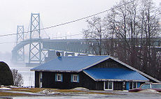
, crossing the St. Lawrence River on the Ogdensburg-Prescott International Bridge
to Ogdensburg, New York
, where it becomes New York State Route 812
.
The Ottawa–Prescott Road was one of the first highways designated in Ontario; it was one of four designated in 1918. The highway was numbered in August 1925.
 The Prescott Highway was established as a provincial highway in 1918, shortly after the Provincial Highway (Highway 2). It remained named until the summer of 1925, when route numbering was introduced and it became Provincial Highway 16. A new route was constructed throughout the 1970s to provide a controlled-access right-of-way for the highway. During the 1990s, this new route was "twinned", whereby a new road was constructed parallel to the existing one, and redesignated as Highway 416. A short section through downtown Ottawa was not incorporated into Highway 416, instead being redesignated as Ottawa Regional Road 44. This left a short stub through Johnstown, which remains designated as Highway 16.
between Ottawa and Highway 401.
Highway 16, which crosses the geologically subdued St. Lawrence Lowlands, was selected over Highway 15, which crosses the undulating Canadian Shield
to the west, as the ideal route for the new link.
To overcome the issue of abutting properties established along the Highway 16 corridor, the DHO began purchasing a new right-of-way between Highway 401 and Century Road by late 1967, and constructed a two lane bypass
of the original alignment, avoiding all the built up areas that the original Highway 16 encountered. This route was designed to easily accommodate the eventual upgrade to a freeway when traffic volumes necessitated.
Construction of the Super two
, dubbed Highway 16 New, took place between 1969 and 1983. The Spencerville
Bypass opened by 1971, connecting with the old highway in the south near Crowder Road and in the north near Ventnor Road.
By the end of 1973 the new highway was completed from immediately north of Highway 401 through Leeds and Grenville United Counties and into Ottawa–Carleton. This included a bypass around Kemptville and a new structure over the Rideau River.
The new highway ended at Dilworth Road (Regional Road 13).
For nearly a decade, no new construction took place. Then, during the summer of 1982, the MTO awarded a contract to begin constructing the route north from Dilworth Road towards Manotick, bypassing North Gower. Following the completion of this first contract, which extended the route as far north as Roger Stevens Drive (Regional Road 6) and included a structure over Stevens Creek, a second contract was awarded for the remaining distance north to Century Road (Regional Road 8).
The project was completed in 1983, merging into the original route of Highway 16 northeast of the present Prince of Wales Drive overpass.
With the completion of Highway 16 New, the MTO need only construct interchanges and the southbound lanes in order to create a full freeway corridor. The upgrade to Highway 416 took place between 1989 and 1999 and was created by the twinning of 57 km (35.4 mi) of Highway 16 New and the construction of an interchange at Highway 401.
, now Leeds and Grenville County Road 2.
From there the route travels northwest adjacent to the Ogdensburg-Prescott International Bridge, which lies to the southwest. A customs plaza lies at the end of the bridge, north of which the road to the bridge meets the highway. To the northeast is single-detached housing. The highway continues, exiting Johnstown and curving slightly towards the north.
Immediately after crossing over a Canadian National track, the route encounters an interchange
with Highway 401, Exit 721B. This parclo interchange features full access to Highway 401, including movements not possible at the Highway 416 interchange to the west. North of the interchange, the road curves gently to the northwest, intersecting Cedar Grove Road. After this, the opposing directions of travel diverge and become ramps to northbound and from southbound Highway 416.
Canada
Canada is a North American country consisting of ten provinces and three territories. Located in the northern part of the continent, it extends from the Atlantic Ocean in the east to the Pacific Ocean in the west, and northward into the Arctic Ocean...
province of Ontario
Ontario
Ontario is a province of Canada, located in east-central Canada. It is Canada's most populous province and second largest in total area. It is home to the nation's most populous city, Toronto, and the nation's capital, Ottawa....
. The highway once travelled from near Prescott
Prescott, Ontario
Prescott is a town of approximately 4,180 people on the north shore of the Saint Lawrence River in Leeds and Grenville United Counties, Ontario, Canada. The Ogdensburg-Prescott International Bridge, 5 km east of Prescott in Johnstown, connects it with Ogdensburg, New York...
to Ottawa
Ottawa
Ottawa is the capital of Canada, the second largest city in the Province of Ontario, and the fourth largest city in the country. The city is located on the south bank of the Ottawa River in the eastern portion of Southern Ontario...
. However, its length was truncated significantly when most of the route was "twinned" with a second roadway, and renumbered as Highway 416. However, a short stub remains through Johnstown
Johnstown, Leeds and Grenville United Counties, Ontario
Johnstown is a community in the United Counties of Leeds and Grenville, in eastern Ontario, Canada, part of the township of Edwardsburgh/Cardinal. It is located at the Canadian terminus of the Ogdensburg-Prescott International Bridge and at the southern terminus of Highway 416 and Highway...
, crossing the St. Lawrence River on the Ogdensburg-Prescott International Bridge
Ogdensburg-Prescott International Bridge
The Ogdensburg–Prescott International Bridge, also known as the St. Lawrence Bridge and the Seaway Skyway, is a suspension bridge connecting Ogdensburg, New York in the United States to Johnstown, Ontario in Canada...
to Ogdensburg, New York
Ogdensburg, New York
Ogdensburg is a city in St. Lawrence County, New York, United States. The population was 11,128 at the 2010 census. In the late 18th century, European-American settlers named the community after American land owner and developer Samuel Ogden....
, where it becomes New York State Route 812
New York State Route 812
New York State Route 812 is a state highway in the North Country of New York in the United States. The southern terminus of the route is at an intersection with NY 12 and NY 26 in the Lewis County village of Lowville...
.
The Ottawa–Prescott Road was one of the first highways designated in Ontario; it was one of four designated in 1918. The highway was numbered in August 1925.
History
Highway 16 New
In 1966 the Eastern Ontario Highway Planning Study was published the Department of Highways (DHO), the predecessor to today's Ministry of Transportation of Ontario (MTO), identifying the need for a controlled-access highwayControlled-access highway
A controlled-access highway is a highway designed exclusively for high-speed vehicular traffic, with all traffic flow and ingress/egress regulated...
between Ottawa and Highway 401.
Highway 16, which crosses the geologically subdued St. Lawrence Lowlands, was selected over Highway 15, which crosses the undulating Canadian Shield
Canadian Shield
The Canadian Shield, also called the Laurentian Plateau, or Bouclier Canadien , is a vast geological shield covered by a thin layer of soil that forms the nucleus of the North American or Laurentia craton. It is an area mostly composed of igneous rock which relates to its long volcanic history...
to the west, as the ideal route for the new link.
To overcome the issue of abutting properties established along the Highway 16 corridor, the DHO began purchasing a new right-of-way between Highway 401 and Century Road by late 1967, and constructed a two lane bypass
Bypass (road)
A bypass is a road or highway that avoids or "bypasses" a built-up area, town, or village, to let through traffic flow without interference from local traffic, to reduce congestion in the built-up area, and to improve road safety....
of the original alignment, avoiding all the built up areas that the original Highway 16 encountered. This route was designed to easily accommodate the eventual upgrade to a freeway when traffic volumes necessitated.
Construction of the Super two
Super two
A super two, super two-lane highway or wide two lane is a two-lane surface road built to high standards, typically including partial control of access, occasional passing lanes and hard shoulders...
, dubbed Highway 16 New, took place between 1969 and 1983. The Spencerville
Spencerville, Ontario
The village of Spencerville is a rural community located in Eastern Ontario, about 80 kilometres southwest of downtown Ottawa on Highway 416. The village lies within the amalgamated municipality of Edwardsburgh/Cardinal in the United Counties of Leeds and Grenville.The twinning of former Highway 16...
Bypass opened by 1971, connecting with the old highway in the south near Crowder Road and in the north near Ventnor Road.
By the end of 1973 the new highway was completed from immediately north of Highway 401 through Leeds and Grenville United Counties and into Ottawa–Carleton. This included a bypass around Kemptville and a new structure over the Rideau River.
The new highway ended at Dilworth Road (Regional Road 13).
For nearly a decade, no new construction took place. Then, during the summer of 1982, the MTO awarded a contract to begin constructing the route north from Dilworth Road towards Manotick, bypassing North Gower. Following the completion of this first contract, which extended the route as far north as Roger Stevens Drive (Regional Road 6) and included a structure over Stevens Creek, a second contract was awarded for the remaining distance north to Century Road (Regional Road 8).
The project was completed in 1983, merging into the original route of Highway 16 northeast of the present Prince of Wales Drive overpass.
With the completion of Highway 16 New, the MTO need only construct interchanges and the southbound lanes in order to create a full freeway corridor. The upgrade to Highway 416 took place between 1989 and 1999 and was created by the twinning of 57 km (35.4 mi) of Highway 16 New and the construction of an interchange at Highway 401.
Route description
Highway 16 is now a very brief route, though it was much longer before the construction of Highway 416 truncated it. The highway begins near the shores of the St. Lawrence River in Johnstown at the former Highway 2Ontario Highway 2
King's Highway 2, usually referred to simply as Highway 2 is a provincially maintained highway in Ontario. Once the primary east–west route across the southern end of the province, Highway 2 became mostly redundant in the 1960s following the completion of Highway 401, which more or less...
, now Leeds and Grenville County Road 2.
From there the route travels northwest adjacent to the Ogdensburg-Prescott International Bridge, which lies to the southwest. A customs plaza lies at the end of the bridge, north of which the road to the bridge meets the highway. To the northeast is single-detached housing. The highway continues, exiting Johnstown and curving slightly towards the north.
Immediately after crossing over a Canadian National track, the route encounters an interchange
Interchange (road)
In the field of road transport, an interchange is a road junction that typically uses grade separation, and one or more ramps, to permit traffic on at least one highway to pass through the junction without directly crossing any other traffic stream. It differs from a standard intersection, at which...
with Highway 401, Exit 721B. This parclo interchange features full access to Highway 401, including movements not possible at the Highway 416 interchange to the west. North of the interchange, the road curves gently to the northwest, intersecting Cedar Grove Road. After this, the opposing directions of travel diverge and become ramps to northbound and from southbound Highway 416.
Major intersections
The following table lists the major junctions along Highway 16. The entirety of the highway is located within Leeds and Grenville United Counties.| Location | km | Destinations | Notes |
|---|---|---|---|
| Johnstown Johnstown, Leeds and Grenville United Counties, Ontario Johnstown is a community in the United Counties of Leeds and Grenville, in eastern Ontario, Canada, part of the township of Edwardsburgh/Cardinal. It is located at the Canadian terminus of the Ogdensburg-Prescott International Bridge and at the southern terminus of Highway 416 and Highway... |
0.0 | Access to Ogdensburg-Prescott International Bridge Ogdensburg-Prescott International Bridge The Ogdensburg–Prescott International Bridge, also known as the St. Lawrence Bridge and the Seaway Skyway, is a suspension bridge connecting Ogdensburg, New York in the United States to Johnstown, Ontario in Canada... |
|
| Edwardsburgh/Cardinal | 1.5 | , Montreal Montreal Montreal is a city in Canada. It is the largest city in the province of Quebec, the second-largest city in Canada and the seventh largest in North America... |
Exit 721B |
| 2.2 | Cedar Grove Road |
Old Highway 16 alignment | |
| 3.8 | Northbound access to and southbound access from Highway 416 |