

2008 Super Tuesday tornado outbreak
Encyclopedia
The 2008 Super Tuesday tornado outbreak was a deadly tornado
outbreak
which affected the Southern United States
and the lower Ohio Valley on February 5 and 6, 2008. The event began on Super Tuesday
, while 24 U.S.
states were holding primary elections and caucus
es to select the presidential candidates for the upcoming presidential election. Missouri
, Illinois
, Arkansas
, Alabama
, and Tennessee
were among the affected regions in which primaries were being held. Some voting locations were forced to close early due to the approaching severe weather.
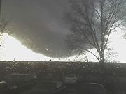
Eighty-seven tornadoes occurred over the course of the outbreak, which lasted over 15 hours from the afternoon of February 5 until the early morning of February 6. The storm system produced several destructive tornadoes in heavily populated areas, most notably in the Memphis metropolitan area
, in Jackson, Tennessee
, and the northeastern end of the Nashville metropolitan area. 57 people were killed across four states and 18 counties, with hundreds of others injured. The outbreak, at the time, was the deadliest in the era of modern NEXRAD
doppler radar, which was fully implemented in 1997. The tornado outbreak was the second deadliest outbreak in February since 1950 behind the February 1971 Mississippi Valley tornado outbreak, which killed 123. It was also the deadliest outbreak in both Tennessee
and Kentucky
since the 1974 Super Outbreak
. Damage from tornadoes was estimated at over $500 million (2008 USD).
The weather system which produced the tornadoes caused significant straight-line wind
damage, hail
as large as softball
s – 4.5 inches (11 cm) in diameter – major flooding, significant freezing rain
, and heavy snow across many areas of eastern North America
. The total damage from the entire weather system exceeded $1 billion.
 A series of strong low pressure systems
formed across the southern Great Plains
on February 4, contributing to record warmth on February 4 and 5 in the southern Plains and lower Mississippi River
Valley. High temperatures across many areas reached the 70's°F (21–26 °C), and in Alabama temperatures reached the low 80's°F (27 °C) with dew point
s in the middle 60's° (17–20 °C). Dewpoints in the mid 60's°F were recorded as far north as Memphis. A strong cold front
trailing the low pressure area approached the region from the west.
The high temperatures and dew points created moderate instability
across the outbreak area. CAPE
values, a measurement for the level of tropospheric
instability, were over 1000 J/kg, and helicity levels
, a measurement of the potential for rotating winds, reached over 200 m²/s². The upper level jet stream
also contributed a large amount of wind shear
. These factors were all indicative of a high potential for severe weather.
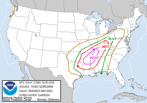
On February 5 at 6:39 am CST (1239 UTC
), the Storm Prediction Center
(SPC) issued a high risk of severe storms for most of Arkansas
; the first in February since 1998. At 10:16 am CST (1616 UTC), the high risk area was extended farther northeast to include western Kentucky
, northwestern Mississippi
, the Missouri
Bootheel, West Tennessee
, and Southern
Illinois
. A moderate risk of severe weather was issued for northwestern Alabama
, the rest of Arkansas
, the rest of southern Illinois, southern Indiana
, most of the rest of Kentucky
, northern Louisiana
, central Mississippi
, parts of southeastern Missouri
, southwestern Ohio
, eastern Oklahoma
, middle Tennessee
and northeastern Texas
. A total of fifteen watches were issued by the SPC during the outbreak, including thirteen tornado watch
es (two of which were PDS watches
) and two severe thunderstorm watch
es.
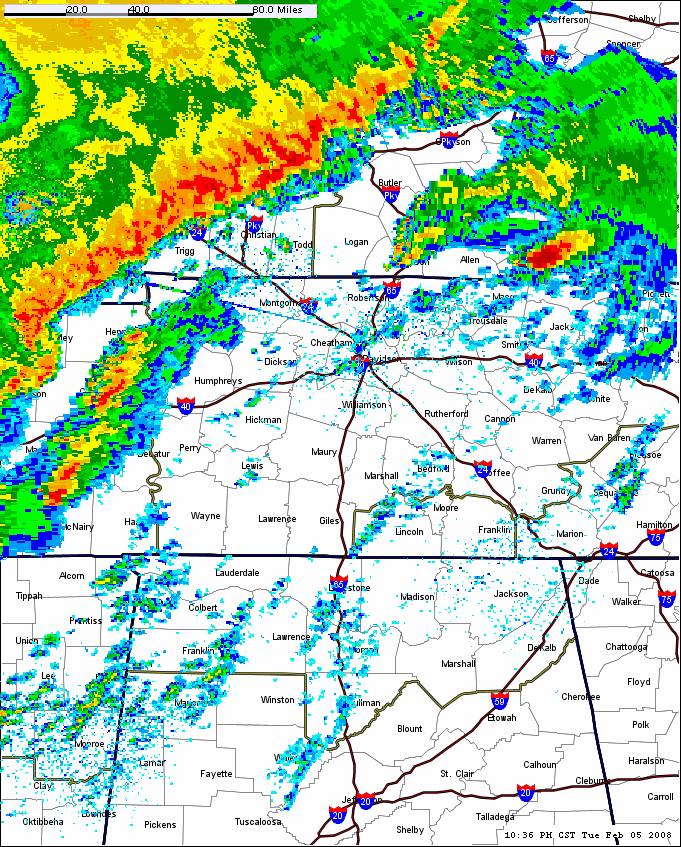
Early on the morning of February 5, a squall line
developed across eastern Texas northward into Missouri and moved east towards the high risk area. Ahead of the squall line, the cap
took longer than expected to break, but when it finally did in the late afternoon hours, numerous supercell
thunderstorms quickly formed across Arkansas and southern Missouri. The first tornadoes touched down around 3:30 pm CST (2130 UTC). A cap is a layer of relatively warm air aloft (usually several thousand feet above the ground) which suppresses or delays the development of thunderstorms; the cap often prevents or delays thunderstorm development even in the presence of extreme instability. However, if the cap is removed or weakened, then explosive thunderstorm development can occur. Some of the most powerful tornado producing supercells were situated across the Memphis and Jackson areas, as well as central Arkansas (one producing a tornado that tracked 122 miles (196 km) and lasting about two hours) between 5:00 and 7:30 pm CST (2300 to 0130 UTC) while numerous other tornadoes were reported across northern Mississippi northwest of Tupelo, Mississippi
early in the evening. As the evening progressed, one of these supercells traveled across Middle Tennessee including the Nashville
metropolitan area and south-central Kentucky, where several deadly tornadoes were reported during the evening hours between 7:30 pm and 11:00 pm CST (0130 to 0500 UTC).
 Meanwhile, the squall line that developed from near Dallas
to Kansas City
moved eastward throughout the late evening and overnight hours causing numerous reports of damaging wind along with many spin-up tornadoes from Louisiana to Ohio and Indiana. It then moved through the southeast U.S.
during the early morning hours. Additional strong thunderstorms developed ahead of the front across the southeast during the overnight and early morning hours. A record of five tornado emergency
declarations were issued on February 5; four for Tennessee, and one in Alabama.
On February 6, a slight risk of severe weather was issued for much of the eastern United States
from Pennsylvania
to the Florida Panhandle
as the squall line raced eastward ahead of the cold front. After several additional tornadoes touched down in Alabama during the early morning hours just before dawn, the primary severe weather threat became damaging wind across the Mid-Atlantic States. No additional tornadoes were reported during the late morning and afternoon as the cold front exited into the Atlantic Ocean, although wind damage was reported across eastern Kentucky, eastern Pennsylvania and most of Georgia
. Farther north, snow and freezing rain, at times heavy, continued from Iowa
to Quebec
until February 7 as the center of the system moved slowly out of the area.

in Yell County
. The tornado tracked into Pope County, striking the community of Atkins
. Four people died in Atkins and much of the town was destroyed. The tornado continued on and crossed into Conway County where it killed two more people, injured five others, and destroyed numerous homes.
The next hard hit town was Clinton
in Van Buren County, where three people died. One of these deaths occurred at a boat manufacturing facility which was destroyed. The tornado continued into Stone County, where one person was killed. In the town of Mountain View
the local hospital
lost its roof and a fire station was destroyed. The tornado affected mostly rural areas for the rest of its path, but two additional people were killed in Izard County before it finally lifted back into the clouds northeast of Highland
in Sharp County
, about two hours after it initially touched down.
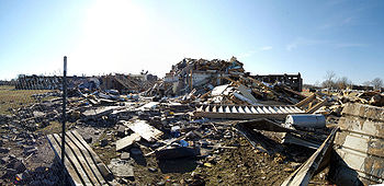
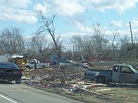
An aerial survey later determined that the damage across the seven counties was caused by one tornado, with a track estimated at 122 miles (196 km) in length. This was the longest single tornado track recorded in Arkansas since detailed record keeping began in 1950. The tornado was rated an EF4 on the Enhanced Fujita Scale. Thirteen people were killed by this tornado, and about 140 people were injured. Approximately 200 homes and businesses were destroyed along the tornado's path. Damage from this tornado was estimated at nearly $120 million across the seven counties.
 At 5:32 pm CST (2332 UTC), a supercell thunderstorm produced a tornado in Southaven, Mississippi
, inflicting heavy damage upon Southaven High School
, now Southaven Middle School. The tornado quickly tracked across the Mississippi – Tennessee state line and into southeastern portions of Memphis
, where WREG tower cameras showed the tornado tracking across Memphis' southeastern suburbs, particularly over Southaven, Mississippi
. National Weather Service officials issued a tornado emergency
(the first of five in the outbreak) for most of the Memphis metropolitan region. This tornado produced a swath of extensive damage over residential and commercial areas. Hickory Ridge Mall
suffered damage when portions of a wall and roof were destroyed. Major damage was also reported in the Pleasant Ridge area of Germantown
in the southern end of Memphis. In addition, damage was reported at Memphis International Airport
, where a hangar
lost its roof, the FedEx
freight terminal's fire station suffered roof damage, airstair
trucks were thrown 100 yards (91 m), and aircraft were moved around, including a Boeing 737
that was moved one foot. FedEx service was disrupted due to flight delays and closed roads, all because of the tornado damage in surrounding areas. The airport weather station's reporting equipment recorded a wind gust of 73 knots (84 mph, 135 km/h). The Hardy Bottling Company facility was also damaged, which released 120,000 pounds (54,500 kg) of anhydrous ammonia into the atmosphere, although no public health impacts were reported. Electricity supply to about 65,000 customers was briefly cut.
The National Weather Service
office in Memphis rated the tornado as an EF2. Four people in the metropolitan area were killed; three of whom were in a warehouse when it collapsed in the Hickory Hill section of Memphis. A spokesperson for the state's Emergency Management Agency also reported one fatality at the Hickory Ridge Mall, although the NWS office in Memphis did not confirm this. Thirty-six other people were injured in Shelby County by the tornadoes. One additional death took place southeast of Hebron from a separate EF3 tornado. Shelby County Election Commission administrator James Johnson stated the weather did not interfere with Super Tuesday primary voting.
 Farther northeast near Jackson, Tennessee
, a tornado touchdown caused the issuance of another tornado emergency (the second of the outbreak) at 7:00 pm CST (0100 UTC). This tornado was spawned by the same supercell that had affected Memphis about an hour earlier. Several cars and at least 15 tractor trailers were overturned by the tornado along Interstate 40
between mile markers 68 and 79. In addition, the areas southwest of Jackson saw severe damage, including destroyed homes and major damage to a church and a rest area
along I-40. Major damage was also reported in a commercial area near the U.S. Route 45
bypass and to the northeast of Jackson.
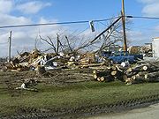
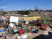
The most severe damage was at the devastated Union University
, where a total of 31 buildings on the campus received damage of varying degrees. Hurt, Watters, and McAfee dormitories
were the hardest hit with approximately 80% of their accommodation rendered uninhabitable. Twelve students at the university were trapped in damaged buildings but all were eventually rescued. Due to the damage, the university was closed until February 18.
The National Weather Service
rated the tornado as an EF4 and later determined that there were two distinct tracks, with an EF3 satellite tornado to the southwest of the main one. It was originally believed a third (an EF3) touched down but it was later found to be linked to the main one that hit Union University. This was the third violent tornado to hit Jackson in 10 years. Two others, both rated F4, had devastated the community on January 17, 1999
and May 4, 2003
.
Over 60 people in the Jackson area were treated for injuries as a result of the severe weather, 50 of whom were released immediately. No fatalities were caused by the main Jackson tornado, however two fatalities occurred in the Huntersville community, located west of Jackson, from the initial EF3 tornado. Estimates indicate that the tornadoes caused about $47 million worth of damages in Madison County, with $40 million of that total occurring at Union University alone.
 Just after 9:00 PM CST (0300 UTC), a supercell that spawned tornadoes over northern Mississippi as well as causing fatalities in Hardin County, Tennessee
, moved to the northeast over Nashville
. Fortunately, no tornadoes were reported there (although there were reports of funnel cloud
s) and no significant damage was reported in Nashville or Davidson County
. At the time the supercell moved over Nashville, a National Hockey League
game between the Nashville Predators
and the Carolina Hurricanes
, which was nationally televised on Versus, was being played at the Sommet Center. With just over nine minutes left in the third period, Predators head coach Barry Trotz
was told that the game may have to be stopped. Although the game continued to completion, at the game's end fans were not allowed to leave the arena until the storm had passed.
 After the supercell moved through Nashville the environment became more favorable again and a strong tornado did touch down, devastating a lengthy swath of Middle Tennessee
in the late evening hours and killing 22 people. The tornado touched down near Castalian Springs
and Westmoreland
, a rural area in Sumner County, Tennessee
, just after 10:00 pm CST (0400 UTC). Eight fatalities were confirmed in Castalian Springs due to the tornado, the last occurring two weeks later. The 19th century Wynnewood Inn
, a national historical landmark, suffered major damage to its second level and grounds during the storm.
The tornado then tracked into Trousdale County and left three people dead, two of whom were found at a home along U.S. Route 231
. From there the tornado continued northeast to Macon County, Tennessee where 13 people died.
As a result of the tornado, a major fire
occurred at a natural gas
plant near the small community of Green Grove in the extreme southwestern portion of the county. The area was evacuated and no one was injured at the plant. Widespread damage in the area was also reported to houses and trailers, particularly in the community of Lafayette
. Debris from the Lafayette area was found as far north as Sano, Kentucky in Adair County
, approximately 70 miles (113 km) to the northeast. Sixteen thousand TVA
electricity customers in Macon and Trousdale Counties lost power, some of whom did not have their service restored for a week. Macon County schools were closed until February 19. In total, about 260 houses in the three counties were destroyed, and damage amounts were estimated at $78 million in Macon County alone. In addition, on March 13, 2008, the tornado claimed the life of a 14th Macon County resident who had been critically injured.
The tornado continued across the state boundary into Kentucky
where a metal warehouse, two homes and two mobile homes near Gamaliel
were destroyed, and several other structures suffered extensive damage. Thirteen people from an adjacent trailer park hid inside a basement and were trapped by debris for up to 30 minutes.
 Preliminary surveys by the National Weather Service office in Nashville confirmed that the 22 deaths (which was revised downward from 24 due to double-counting) were caused by a single tornado, which was rated an EF3. The tornado path was 51 miles (82 km) long and up to 0.75 miles (1.21 km) wide. National Weather Service Meteorologist Bobby Boyd theorized that cold air downbursts impinging on the tornado forced it to lift up from the ground and remain a funnel cloud as it crossed over Davidson County
and downtown Nashville before touching down again east of the city.
The devastation was described by Governor Phil Bredesen
as "It looks like the Lord took a Brillo pad and scrubbed the ground" while surveying by helicopter
. The tornado is the deadliest single tornado to strike Middle Tennessee in over 75 years, and the deadliest single US tornado since the Evansville Tornado of November 2005
(which killed 25).
 At approximately 1:00 am CST (0700 UTC), the broken squall line that had affected Oklahoma and Missouri entered the state of Alabama. Individual supercell
storms began to develop ahead of the squall line along the Alabama–Mississippi border due to the strengthening of the upper level jet stream. A supercell that developed over Starkville, Mississippi
and tracked over Lamar
, Marion
and Fayette Counties
in Alabama spawned a tornado in Lawrence County, Alabama
at 3:02 am CST (0902 UTC). The tornado touched down at Pinhook
near the William B. Bankhead National Forest
. Many houses were damaged or destroyed, and a church was leveled. Three fatalities, all from a single family, were reported north of Aldrich Grove. An elderly woman was also killed by the storm, and 20–25 others were injured. The tornado was initially classified as an EF3, although it was upgraded to EF4 in later analysis. The hardest hit communities were the towns of Wren, Speake
and Five Points
. The tornado moved into Morgan County
and threatened the Decatur
area, leading the NWS in Huntsville to issue a tornado emergency
(the fifth for the outbreak) for Morgan County and southern Limestone County
. The tornado lifted off the ground before reaching Decatur. The same supercell moved over the Huntsville Metro area
, though no tornadoes were reported.
at Little Rock National Airport
. The highest recorded wind gust associated with the passage of the squall line was 82 mph (131 km/h) in Terre Haute, Indiana
. Hail
as large as softball
s (4.5 inches (11 cm) in diameter) was reported in several communities. In Canada, unseasonably early thunderstorms brought bouts of heavy rainfall to parts of southern Ontario late on February 4.
, Kentucky, Indiana and Ohio. Among the areas hardest hit by the flooding rivers and streams were the Miami Valley
, areas along the Blanchard River in Findlay
and parts of northern Indiana between Indianapolis
and north of Fort Wayne
along the Tippecanoe
, St. Marys
and Wabash River
s. Several streets in Fort Wayne were under water, and flooding also occurred between Lafayette
and Terre Haute.
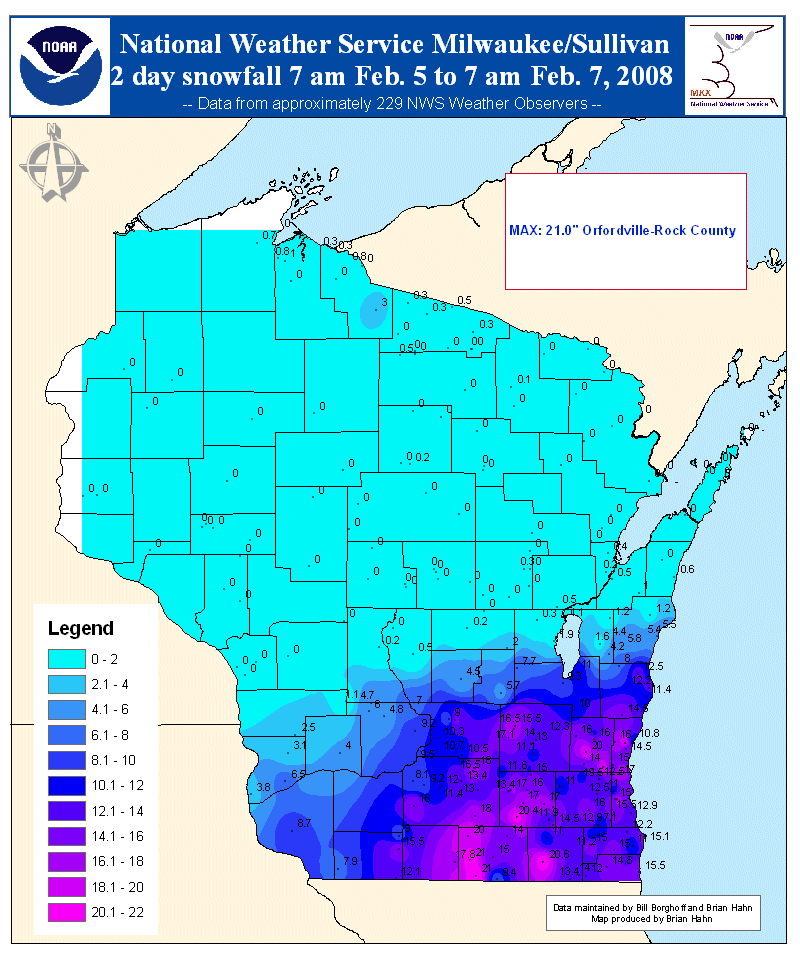 The same low pressure systems that caused the tornado outbreak also spawned a significant snowstorm from the Central Plains to the western Great Lakes where winter storm warning
s were issued. Between 10 and 15 inches (25–38 cm) of snow fell from eastern Iowa to southern Wisconsin
and Northern Illinois
, with local amounts ranging from 18 to 21 inches (45–53 cm) in southeastern Wisconsin. In Michigan
, up to 14 inches (35 cm) of snow fell north of Grand Rapids
. Environment Canada
also issued freezing rain and winter storm warnings for Southern Ontario
, where some areas north of Lake Erie
received close to 1 inch (25 mm) of freezing rain
. In Toronto
, two waves of moderate to heavy snow accompanied by thunder
and lightning, along with ice pellets, brought up to 14 inches (35 cm) of accumulated winter precipitation on February 6 and 7. Other areas from Windsor
to Ottawa, as well as southwestern Nova Scotia
, received from 4 to 20 inches (10–50 cm) of snow.
Over 1,000 flight cancellations were reported at Chicago
's O'Hare International Airport
, and numerous flight cancellations also occurred at Toronto's Pearson International Airport. In Milwaukee
, whiteout conditions and 13 inches (33 cm) of snow briefly shut down the General Mitchell International Airport
. Near Madison, Wisconsin
, about 1,000 vehicles were stranded on Interstate 90
due to the snow. Wisconsin Governor
Jim Doyle
declared a state of emergency for the area and activated the Wisconsin National Guard
. On February 6, numerous schools, colleges, government buildings, churches, businesses, and shopping malls were forced to close throughout southern Wisconsin and northern Illinois due to the inclement weather. The winter storm was responsible for at least four deaths: one each in Illinois, Wisconsin, Michigan and Quebec.
 On February 7 a federal disaster
declaration was made by President
George W. Bush
for 11 counties in Arkansas and five counties in Tennessee. Sixteen additional counties in Tennessee requested federal aid, and on February 12, Tennessee Governor Bredesen announced that eight counties in Tennessee became eligible. President Bush also visited Tennessee to tour the devastated areas on February 8.
The American Red Cross
, the Salvation Army
, the United Way and other charitable groups also quickly mobilized volunteers to assist survivors in the aftermath across the regions affected. In the three hardest hit Middle Tennessee counties alone, the Red Cross sent out over 100 volunteers to deliver meals and supplies. Emergency assistance was also offered by the Tennessee Department of Human Services for low income victims in the counties affected by the tornadoes. In addition, the Nashville Predators
announced that for their game on February 7 against the Tampa Bay Lightning
, half the ticket sales revenue would be donated to the American Red Cross to help with their efforts, and that fans could make additional donations to Red Cross volunteers at the arena's main entrances. The National Football League
's Tennessee Titans
along with the Mayor's Office of Emergency Management of Nashville organized a donation drive during the weekend of February 9 at LP Field
.
Tornado
A tornado is a violent, dangerous, rotating column of air that is in contact with both the surface of the earth and a cumulonimbus cloud or, in rare cases, the base of a cumulus cloud. They are often referred to as a twister or a cyclone, although the word cyclone is used in meteorology in a wider...
outbreak
Tornado outbreak
While there is no single agreed upon definition, generally at least 6-10 tornadoes produced by the same synoptic scale weather system is considered a tornado outbreak. The tornadoes usually occur within the same day, or continue into the early morning hours of the succeeding day, and within the...
which affected the Southern United States
Southern United States
The Southern United States—commonly referred to as the American South, Dixie, or simply the South—constitutes a large distinctive area in the southeastern and south-central United States...
and the lower Ohio Valley on February 5 and 6, 2008. The event began on Super Tuesday
Super Tuesday, 2008
Super Tuesday 2008, Super Duper Tuesday, Mega Tuesday, Giga Tuesday, Tsunami Tuesday, and The Tuesday of Destiny are names for February 5, 2008, the day on which the largest simultaneous number of state U.S. presidential primary elections in the history of U.S. primaries were held...
, while 24 U.S.
United States
The United States of America is a federal constitutional republic comprising fifty states and a federal district...
states were holding primary elections and caucus
Caucus
A caucus is a meeting of supporters or members of a political party or movement, especially in the United States and Canada. As the use of the term has been expanded the exact definition has come to vary among political cultures.-Origin of the term:...
es to select the presidential candidates for the upcoming presidential election. Missouri
Missouri
Missouri is a US state located in the Midwestern United States, bordered by Iowa, Illinois, Kentucky, Tennessee, Arkansas, Oklahoma, Kansas and Nebraska. With a 2010 population of 5,988,927, Missouri is the 18th most populous state in the nation and the fifth most populous in the Midwest. It...
, Illinois
Illinois
Illinois is the fifth-most populous state of the United States of America, and is often noted for being a microcosm of the entire country. With Chicago in the northeast, small industrial cities and great agricultural productivity in central and northern Illinois, and natural resources like coal,...
, Arkansas
Arkansas
Arkansas is a state located in the southern region of the United States. Its name is an Algonquian name of the Quapaw Indians. Arkansas shares borders with six states , and its eastern border is largely defined by the Mississippi River...
, Alabama
Alabama
Alabama is a state located in the southeastern region of the United States. It is bordered by Tennessee to the north, Georgia to the east, Florida and the Gulf of Mexico to the south, and Mississippi to the west. Alabama ranks 30th in total land area and ranks second in the size of its inland...
, and Tennessee
Tennessee
Tennessee is a U.S. state located in the Southeastern United States. It has a population of 6,346,105, making it the nation's 17th-largest state by population, and covers , making it the 36th-largest by total land area...
were among the affected regions in which primaries were being held. Some voting locations were forced to close early due to the approaching severe weather.
Eighty-seven tornadoes occurred over the course of the outbreak, which lasted over 15 hours from the afternoon of February 5 until the early morning of February 6. The storm system produced several destructive tornadoes in heavily populated areas, most notably in the Memphis metropolitan area
Memphis Metropolitan Area
The Memphis Metropolitan Statistical Area, TN-MS-AR , more commonly known as The Mid-South, is the 41st largest among similarly designated areas in the United States. The metropolitan area covers eight counties in three states – Tennessee, Mississippi, and Arkansas...
, in Jackson, Tennessee
Jackson, Tennessee
Jackson is a city in Madison County, Tennessee, United States. The total population was 65,211 at the 2010 census. Jackson is the primary city of the Jackson, Tennessee metropolitan area, which is included in the Jackson-Humboldt, Tennessee Combined Statistical Area...
, and the northeastern end of the Nashville metropolitan area. 57 people were killed across four states and 18 counties, with hundreds of others injured. The outbreak, at the time, was the deadliest in the era of modern NEXRAD
NEXRAD
NEXRAD or Nexrad is a network of 159 high-resolution Doppler weather radars operated by the National Weather Service, an agency of the National Oceanic and Atmospheric Administration within the United States Department of Commerce...
doppler radar, which was fully implemented in 1997. The tornado outbreak was the second deadliest outbreak in February since 1950 behind the February 1971 Mississippi Valley tornado outbreak, which killed 123. It was also the deadliest outbreak in both Tennessee
Tennessee
Tennessee is a U.S. state located in the Southeastern United States. It has a population of 6,346,105, making it the nation's 17th-largest state by population, and covers , making it the 36th-largest by total land area...
and Kentucky
Kentucky
The Commonwealth of Kentucky is a state located in the East Central United States of America. As classified by the United States Census Bureau, Kentucky is a Southern state, more specifically in the East South Central region. Kentucky is one of four U.S. states constituted as a commonwealth...
since the 1974 Super Outbreak
Super Outbreak
The Super Outbreak is the second largest tornado outbreak on record for a single 24-hour period, just behind the tornado outbreak of April 25–28, 2011...
. Damage from tornadoes was estimated at over $500 million (2008 USD).
The weather system which produced the tornadoes caused significant straight-line wind
Downburst
A downburst is created by an area of significantly rain-cooled air that, after reaching ground level, spreads out in all directions producing strong winds. Unlike winds in a tornado, winds in a downburst are directed outwards from the point where it hits land or water...
damage, hail
Hail
Hail is a form of solid precipitation. It consists of balls or irregular lumps of ice, each of which is referred to as a hail stone. Hail stones on Earth consist mostly of water ice and measure between and in diameter, with the larger stones coming from severe thunderstorms...
as large as softball
Softball
Softball is a bat-and-ball sport played between two teams of 10 to 14 players. It is a direct descendant of baseball although there are some key differences: softballs are larger than baseballs, and the pitches are thrown underhand rather than overhand...
s – 4.5 inches (11 cm) in diameter – major flooding, significant freezing rain
Freezing rain
Freezing rain is the name given to rain that falls when surface temperatures are below freezing. The raindrops become supercooled while passing through a sub-freezing layer of air, many hundred feet , just above the surface, and then freeze upon impact with any object they encounter. The resulting...
, and heavy snow across many areas of eastern North America
North America
North America is a continent wholly within the Northern Hemisphere and almost wholly within the Western Hemisphere. It is also considered a northern subcontinent of the Americas...
. The total damage from the entire weather system exceeded $1 billion.
Meteorological synopsis
Low pressure area
A low-pressure area, or "low", is a region where the atmospheric pressure at sea level is below that of surrounding locations. Low-pressure systems form under areas of wind divergence which occur in upper levels of the troposphere. The formation process of a low-pressure area is known as...
formed across the southern Great Plains
Great Plains
The Great Plains are a broad expanse of flat land, much of it covered in prairie, steppe and grassland, which lies west of the Mississippi River and east of the Rocky Mountains in the United States and Canada. This area covers parts of the U.S...
on February 4, contributing to record warmth on February 4 and 5 in the southern Plains and lower Mississippi River
Mississippi River
The Mississippi River is the largest river system in North America. Flowing entirely in the United States, this river rises in western Minnesota and meanders slowly southwards for to the Mississippi River Delta at the Gulf of Mexico. With its many tributaries, the Mississippi's watershed drains...
Valley. High temperatures across many areas reached the 70's°F (21–26 °C), and in Alabama temperatures reached the low 80's°F (27 °C) with dew point
Dew point
The dew point is the temperature to which a given parcel of humid air must be cooled, at constant barometric pressure, for water vapor to condense into liquid water. The condensed water is called dew when it forms on a solid surface. The dew point is a saturation temperature.The dew point is...
s in the middle 60's° (17–20 °C). Dewpoints in the mid 60's°F were recorded as far north as Memphis. A strong cold front
Cold front
A cold front is defined as the leading edge of a cooler mass of air, replacing a warmer mass of air.-Development of cold front:The cooler and denser air wedges under the less-dense warmer air, lifting it...
trailing the low pressure area approached the region from the west.
The high temperatures and dew points created moderate instability
Atmospheric instability
Atmospheric instability is a condition where the atmosphere is generally considered to be unstable and as a result the weather is subject to a high degree of variability through distance and time...
across the outbreak area. CAPE
Convective available potential energy
In meteorology, convective available potential energy , sometimes, simply, available potential energy , is the amount of energy a parcel of air would have if lifted a certain distance vertically through the atmosphere...
values, a measurement for the level of tropospheric
Troposphere
The troposphere is the lowest portion of Earth's atmosphere. It contains approximately 80% of the atmosphere's mass and 99% of its water vapor and aerosols....
instability, were over 1000 J/kg, and helicity levels
Helicity (fluid mechanics)
In fluid mechanics, helicity is the extent to which helix-like motion occurs. If a parcel of fluid is moving, undergoing solid body motion rotating about an axis parallel to the direction of motion, it will have helicity...
, a measurement of the potential for rotating winds, reached over 200 m²/s². The upper level jet stream
Jet stream
Jet streams are fast flowing, narrow air currents found in the atmospheres of some planets, including Earth. The main jet streams are located near the tropopause, the transition between the troposphere and the stratosphere . The major jet streams on Earth are westerly winds...
also contributed a large amount of wind shear
Wind shear
Wind shear, sometimes referred to as windshear or wind gradient, is a difference in wind speed and direction over a relatively short distance in the atmosphere...
. These factors were all indicative of a high potential for severe weather.
On February 5 at 6:39 am CST (1239 UTC
Coordinated Universal Time
Coordinated Universal Time is the primary time standard by which the world regulates clocks and time. It is one of several closely related successors to Greenwich Mean Time. Computer servers, online services and other entities that rely on having a universally accepted time use UTC for that purpose...
), the Storm Prediction Center
Storm Prediction Center
The Storm Prediction Center , located in Norman, Oklahoma, is tasked with forecasting the risk of severe thunderstorms and tornadoes in the contiguous United States. The agency issues convective outlooks, mesoscale discussions, and watches as a part of this process...
(SPC) issued a high risk of severe storms for most of Arkansas
Arkansas
Arkansas is a state located in the southern region of the United States. Its name is an Algonquian name of the Quapaw Indians. Arkansas shares borders with six states , and its eastern border is largely defined by the Mississippi River...
; the first in February since 1998. At 10:16 am CST (1616 UTC), the high risk area was extended farther northeast to include western Kentucky
Kentucky
The Commonwealth of Kentucky is a state located in the East Central United States of America. As classified by the United States Census Bureau, Kentucky is a Southern state, more specifically in the East South Central region. Kentucky is one of four U.S. states constituted as a commonwealth...
, northwestern Mississippi
Mississippi
Mississippi is a U.S. state located in the Southern United States. Jackson is the state capital and largest city. The name of the state derives from the Mississippi River, which flows along its western boundary, whose name comes from the Ojibwe word misi-ziibi...
, the Missouri
Missouri
Missouri is a US state located in the Midwestern United States, bordered by Iowa, Illinois, Kentucky, Tennessee, Arkansas, Oklahoma, Kansas and Nebraska. With a 2010 population of 5,988,927, Missouri is the 18th most populous state in the nation and the fifth most populous in the Midwest. It...
Bootheel, West Tennessee
West Tennessee
West Tennessee is one of the three Grand Divisions of the State of Tennessee. Of the three, it is the one that is most sharply defined geographically. Its boundaries are the Mississippi River on the west and the Tennessee River on the east...
, and Southern
Little Egypt (region)
-Early history:The earliest inhabitants of Illinois were thought to have arrived about 12,000 B.C. They were hunter-gatherers, but developed a primitive system of agriculture. After 1000 AD, their agricultural surpluses enabled them to develop complex, hierarchical societies...
Illinois
Illinois
Illinois is the fifth-most populous state of the United States of America, and is often noted for being a microcosm of the entire country. With Chicago in the northeast, small industrial cities and great agricultural productivity in central and northern Illinois, and natural resources like coal,...
. A moderate risk of severe weather was issued for northwestern Alabama
Alabama
Alabama is a state located in the southeastern region of the United States. It is bordered by Tennessee to the north, Georgia to the east, Florida and the Gulf of Mexico to the south, and Mississippi to the west. Alabama ranks 30th in total land area and ranks second in the size of its inland...
, the rest of Arkansas
Arkansas
Arkansas is a state located in the southern region of the United States. Its name is an Algonquian name of the Quapaw Indians. Arkansas shares borders with six states , and its eastern border is largely defined by the Mississippi River...
, the rest of southern Illinois, southern Indiana
Indiana
Indiana is a US state, admitted to the United States as the 19th on December 11, 1816. It is located in the Midwestern United States and Great Lakes Region. With 6,483,802 residents, the state is ranked 15th in population and 16th in population density. Indiana is ranked 38th in land area and is...
, most of the rest of Kentucky
Kentucky
The Commonwealth of Kentucky is a state located in the East Central United States of America. As classified by the United States Census Bureau, Kentucky is a Southern state, more specifically in the East South Central region. Kentucky is one of four U.S. states constituted as a commonwealth...
, northern Louisiana
Louisiana
Louisiana is a state located in the southern region of the United States of America. Its capital is Baton Rouge and largest city is New Orleans. Louisiana is the only state in the U.S. with political subdivisions termed parishes, which are local governments equivalent to counties...
, central Mississippi
Mississippi
Mississippi is a U.S. state located in the Southern United States. Jackson is the state capital and largest city. The name of the state derives from the Mississippi River, which flows along its western boundary, whose name comes from the Ojibwe word misi-ziibi...
, parts of southeastern Missouri
Missouri
Missouri is a US state located in the Midwestern United States, bordered by Iowa, Illinois, Kentucky, Tennessee, Arkansas, Oklahoma, Kansas and Nebraska. With a 2010 population of 5,988,927, Missouri is the 18th most populous state in the nation and the fifth most populous in the Midwest. It...
, southwestern Ohio
Ohio
Ohio is a Midwestern state in the United States. The 34th largest state by area in the U.S.,it is the 7th‑most populous with over 11.5 million residents, containing several major American cities and seven metropolitan areas with populations of 500,000 or more.The state's capital is Columbus...
, eastern Oklahoma
Oklahoma
Oklahoma is a state located in the South Central region of the United States of America. With an estimated 3,751,351 residents as of the 2010 census and a land area of 68,667 square miles , Oklahoma is the 28th most populous and 20th-largest state...
, middle Tennessee
Middle Tennessee
Middle Tennessee is a distinct portion of the state of Tennessee, delineated according to state law as the 41 counties in the Middle Grand Division of Tennessee....
and northeastern Texas
Texas
Texas is the second largest U.S. state by both area and population, and the largest state by area in the contiguous United States.The name, based on the Caddo word "Tejas" meaning "friends" or "allies", was applied by the Spanish to the Caddo themselves and to the region of their settlement in...
. A total of fifteen watches were issued by the SPC during the outbreak, including thirteen tornado watch
Tornado watch
A tornado watch is issued when conditions are right for a tornado to form. Since any thunderstorm capable of producing a tornado is defined as severe, a tornado watch is also automatically a severe thunderstorm watch...
es (two of which were PDS watches
Particularly dangerous situation
A particularly dangerous situation is a type of enhanced wording first used by the National Weather Service's Storm Prediction Center in Norman, Oklahoma on certain severe weather watches...
) and two severe thunderstorm watch
Severe thunderstorm watch
[File:Annual_severe_thunderstorm_watch_frequency_in_the_United_States.svg|thumb|right|300px|Map of average annual severe thunderstorm watches in the United States between 1999 and 2008.Legend:...
es.
Early on the morning of February 5, a squall line
Squall line
A squall line is a line of severe thunderstorms that can form along or ahead of a cold front. In the early 20th century, the term was used as a synonym for cold front. It contains heavy precipitation, hail, frequent lightning, strong straight-line winds, and possibly tornadoes and waterspouts....
developed across eastern Texas northward into Missouri and moved east towards the high risk area. Ahead of the squall line, the cap
Capping inversion
A capping inversion is an elevated inversion layer that caps a convective boundary layer.The boundary layer is the part of the atmosphere which is closest to the ground. Normally, the sun heats the ground, which in turn heats the air just above it. Thermals form when this warm air rises into the...
took longer than expected to break, but when it finally did in the late afternoon hours, numerous supercell
Supercell
A supercell is a thunderstorm that is characterized by the presence of a mesocyclone: a deep, continuously-rotating updraft. For this reason, these storms are sometimes referred to as rotating thunderstorms...
thunderstorms quickly formed across Arkansas and southern Missouri. The first tornadoes touched down around 3:30 pm CST (2130 UTC). A cap is a layer of relatively warm air aloft (usually several thousand feet above the ground) which suppresses or delays the development of thunderstorms; the cap often prevents or delays thunderstorm development even in the presence of extreme instability. However, if the cap is removed or weakened, then explosive thunderstorm development can occur. Some of the most powerful tornado producing supercells were situated across the Memphis and Jackson areas, as well as central Arkansas (one producing a tornado that tracked 122 miles (196 km) and lasting about two hours) between 5:00 and 7:30 pm CST (2300 to 0130 UTC) while numerous other tornadoes were reported across northern Mississippi northwest of Tupelo, Mississippi
Tupelo, Mississippi
Tupelo is the largest city in and the county seat of Lee County, Mississippi, United States. It is the seventh largest city in the state of Mississippi, smaller than Meridian, and larger than Greenville. As of the 2000 United States Census, the city's population was 34,211...
early in the evening. As the evening progressed, one of these supercells traveled across Middle Tennessee including the Nashville
Nashville, Tennessee
Nashville is the capital of the U.S. state of Tennessee and the county seat of Davidson County. It is located on the Cumberland River in Davidson County, in the north-central part of the state. The city is a center for the health care, publishing, banking and transportation industries, and is home...
metropolitan area and south-central Kentucky, where several deadly tornadoes were reported during the evening hours between 7:30 pm and 11:00 pm CST (0130 to 0500 UTC).
Dallas, Texas
Dallas is the third-largest city in Texas and the ninth-largest in the United States. The Dallas-Fort Worth Metroplex is the largest metropolitan area in the South and fourth-largest metropolitan area in the United States...
to Kansas City
Kansas City, Missouri
Kansas City, Missouri is the largest city in the U.S. state of Missouri and is the anchor city of the Kansas City Metropolitan Area, the second largest metropolitan area in Missouri. It encompasses in parts of Jackson, Clay, Cass, and Platte counties...
moved eastward throughout the late evening and overnight hours causing numerous reports of damaging wind along with many spin-up tornadoes from Louisiana to Ohio and Indiana. It then moved through the southeast U.S.
Southeastern United States
The Southeastern United States, colloquially referred to as the Southeast, is the eastern portion of the Southern United States. It is one of the most populous regions in the United States of America....
during the early morning hours. Additional strong thunderstorms developed ahead of the front across the southeast during the overnight and early morning hours. A record of five tornado emergency
Tornado emergency
A Tornado Emergency is enhanced wording of tornado warnings used by the National Weather Service in the United States during significant tornado occurrences in highly populated areas...
declarations were issued on February 5; four for Tennessee, and one in Alabama.
On February 6, a slight risk of severe weather was issued for much of the eastern United States
Eastern United States
The Eastern United States, the American East, or simply the East is traditionally defined as the states east of the Mississippi River. The first two tiers of states west of the Mississippi have traditionally been considered part of the West, but can be included in the East today; usually in...
from Pennsylvania
Pennsylvania
The Commonwealth of Pennsylvania is a U.S. state that is located in the Northeastern and Mid-Atlantic regions of the United States. The state borders Delaware and Maryland to the south, West Virginia to the southwest, Ohio to the west, New York and Ontario, Canada, to the north, and New Jersey to...
to the Florida Panhandle
Florida Panhandle
The Florida Panhandle, an informal, unofficial term for the northwestern part of Florida, is a strip of land roughly 200 miles long and 50 to 100 miles wide , lying between Alabama on the north and the west, Georgia also on the north, and the Gulf of Mexico to the south. Its eastern boundary is...
as the squall line raced eastward ahead of the cold front. After several additional tornadoes touched down in Alabama during the early morning hours just before dawn, the primary severe weather threat became damaging wind across the Mid-Atlantic States. No additional tornadoes were reported during the late morning and afternoon as the cold front exited into the Atlantic Ocean, although wind damage was reported across eastern Kentucky, eastern Pennsylvania and most of Georgia
Georgia (U.S. state)
Georgia is a state located in the southeastern United States. It was established in 1732, the last of the original Thirteen Colonies. The state is named after King George II of Great Britain. Georgia was the fourth state to ratify the United States Constitution, on January 2, 1788...
. Farther north, snow and freezing rain, at times heavy, continued from Iowa
Iowa
Iowa is a state located in the Midwestern United States, an area often referred to as the "American Heartland". It derives its name from the Ioway people, one of the many American Indian tribes that occupied the state at the time of European exploration. Iowa was a part of the French colony of New...
to Quebec
Quebec
Quebec or is a province in east-central Canada. It is the only Canadian province with a predominantly French-speaking population and the only one whose sole official language is French at the provincial level....
until February 7 as the center of the system moved slowly out of the area.
Tornadoes reported
North-central Arkansas tornado
The first long-lived supercell, which spawned the tornado with the longest continuous track of any single tornado in this outbreak, developed around 4:50 pm CST (2250 UTC) southeast of CentervilleCenterville, Yell County, Arkansas
Centerville is an unincorporated community in Yell County, Arkansas, United States. Centerville is located at the junction of Arkansas Highway 7 and Arkansas Highway 154 north-northeast of Ola. Centerville has a post office with ZIP code 72829....
in Yell County
Yell County, Arkansas
Yell County is a county located in the U.S. state of Arkansas. As of 2010, the population was 22,185. The county has two county seats, Dardanelle and Danville...
. The tornado tracked into Pope County, striking the community of Atkins
Atkins, Arkansas
Atkins is a city in Pope County, Arkansas, United States. The population was 2,878 at the 2000 census. It is part of the Russellville Micropolitan Statistical Area.-Geography:Atkins is located at ....
. Four people died in Atkins and much of the town was destroyed. The tornado continued on and crossed into Conway County where it killed two more people, injured five others, and destroyed numerous homes.
The next hard hit town was Clinton
Clinton, Arkansas
Clinton is the county seat of Van Buren County, Arkansas, United States. The population was 2,283 at the 2000 census. The city was named for DeWitt Clinton, the New York governor who built the Erie Canal; he previously was also a U.S. Senator from New York. Clinton is located at...
in Van Buren County, where three people died. One of these deaths occurred at a boat manufacturing facility which was destroyed. The tornado continued into Stone County, where one person was killed. In the town of Mountain View
Mountain View, Arkansas
Mountain View is the largest city in and the county seat of Stone County in the north-central region of the U.S. state of Arkansas. According to 2005 Census Bureau estimates, the population of the city was 2,998. The town's name comes from its location in a valley surrounded by the eastern Ozark...
the local hospital
Hospital
A hospital is a health care institution providing patient treatment by specialized staff and equipment. Hospitals often, but not always, provide for inpatient care or longer-term patient stays....
lost its roof and a fire station was destroyed. The tornado affected mostly rural areas for the rest of its path, but two additional people were killed in Izard County before it finally lifted back into the clouds northeast of Highland
Highland, Arkansas
Highland is a city in Sharp County, Arkansas, United States. The population was 986 at the 2000 census.-Geography:Highland is located at ....
in Sharp County
Sharp County, Arkansas
-External links:*...
, about two hours after it initially touched down.
An aerial survey later determined that the damage across the seven counties was caused by one tornado, with a track estimated at 122 miles (196 km) in length. This was the longest single tornado track recorded in Arkansas since detailed record keeping began in 1950. The tornado was rated an EF4 on the Enhanced Fujita Scale. Thirteen people were killed by this tornado, and about 140 people were injured. Approximately 200 homes and businesses were destroyed along the tornado's path. Damage from this tornado was estimated at nearly $120 million across the seven counties.
Memphis area tornado
Southaven, Mississippi
-Households And Families:As of the census of 2000, there were 28,977 people, 11,007 households, and 8,134 families residing in the city. The population density was 857.9 people per square mile...
, inflicting heavy damage upon Southaven High School
Southaven High School
Southaven High School is a public secondary school located in Southaven, Mississippi. It currently is serving students in grades 9-12. The school is part of the DeSoto County School District. It currently has an enrollment of 1,426 students and staffs 87 faculty...
, now Southaven Middle School. The tornado quickly tracked across the Mississippi – Tennessee state line and into southeastern portions of Memphis
Memphis, Tennessee
Memphis is a city in the southwestern corner of the U.S. state of Tennessee, and the county seat of Shelby County. The city is located on the 4th Chickasaw Bluff, south of the confluence of the Wolf and Mississippi rivers....
, where WREG tower cameras showed the tornado tracking across Memphis' southeastern suburbs, particularly over Southaven, Mississippi
Southaven, Mississippi
-Households And Families:As of the census of 2000, there were 28,977 people, 11,007 households, and 8,134 families residing in the city. The population density was 857.9 people per square mile...
. National Weather Service officials issued a tornado emergency
Tornado emergency
A Tornado Emergency is enhanced wording of tornado warnings used by the National Weather Service in the United States during significant tornado occurrences in highly populated areas...
(the first of five in the outbreak) for most of the Memphis metropolitan region.
Hickory Ridge Mall
Hickory Ridge Mall is a community shopping mall located in Memphis, Tennessee. It is anchored by Sears and America's Incredible Pizza Company. It was severely damaged by a tornado on February 5, 2008...
suffered damage when portions of a wall and roof were destroyed. Major damage was also reported in the Pleasant Ridge area of Germantown
Germantown, Tennessee
Germantown is a city in Shelby County, Tennessee. The population was 38,844 at the 2010 census.Germantown is a suburb of Memphis, bordering it to the east. Germantown's economy is dominated by the retail and commercial service sectors; there is no heavy industry in Germantown...
in the southern end of Memphis. In addition, damage was reported at Memphis International Airport
Memphis International Airport
Memphis International Airport is a joint civil-military public airport located three miles south of the central business district of Memphis, a city in Shelby County, Tennessee, United States....
, where a hangar
Hangar
A hangar is a closed structure to hold aircraft or spacecraft in protective storage. Most hangars are built of metal, but other materials such as wood and concrete are also sometimes used...
lost its roof, the FedEx
FedEx
FedEx Corporation , originally known as FDX Corporation, is a logistics services company, based in the United States with headquarters in Memphis, Tennessee...
freight terminal's fire station suffered roof damage, airstair
Airstair
An airstair is a passenger staircase that is built in to an airliner — often, though not always, on the inside of a clamshell-style door. The stairs can be raised or lowered while the aircraft is on the ground, allowing passengers and ground personnel to board or depart the aircraft without the...
trucks were thrown 100 yards (91 m), and aircraft were moved around, including a Boeing 737
Boeing 737
The Boeing 737 is a short- to medium-range, twin-engine narrow-body jet airliner. Originally developed as a shorter, lower-cost twin-engine airliner derived from Boeing's 707 and 727, the 737 has developed into a family of nine passenger models with a capacity of 85 to 215 passengers...
that was moved one foot. FedEx service was disrupted due to flight delays and closed roads, all because of the tornado damage in surrounding areas. The airport weather station's reporting equipment recorded a wind gust of 73 knots (84 mph, 135 km/h). The Hardy Bottling Company facility was also damaged, which released 120,000 pounds (54,500 kg) of anhydrous ammonia into the atmosphere, although no public health impacts were reported. Electricity supply to about 65,000 customers was briefly cut.
The National Weather Service
National Weather Service
The National Weather Service , once known as the Weather Bureau, is one of the six scientific agencies that make up the National Oceanic and Atmospheric Administration of the United States government...
office in Memphis rated the tornado as an EF2. Four people in the metropolitan area were killed; three of whom were in a warehouse when it collapsed in the Hickory Hill section of Memphis. A spokesperson for the state's Emergency Management Agency also reported one fatality at the Hickory Ridge Mall, although the NWS office in Memphis did not confirm this. Thirty-six other people were injured in Shelby County by the tornadoes. One additional death took place southeast of Hebron from a separate EF3 tornado. Shelby County Election Commission administrator James Johnson stated the weather did not interfere with Super Tuesday primary voting.
Jackson area tornado
Jackson, Tennessee
Jackson is a city in Madison County, Tennessee, United States. The total population was 65,211 at the 2010 census. Jackson is the primary city of the Jackson, Tennessee metropolitan area, which is included in the Jackson-Humboldt, Tennessee Combined Statistical Area...
, a tornado touchdown caused the issuance of another tornado emergency (the second of the outbreak) at 7:00 pm CST (0100 UTC). This tornado was spawned by the same supercell that had affected Memphis about an hour earlier. Several cars and at least 15 tractor trailers were overturned by the tornado along Interstate 40
Interstate 40
Interstate 40 is the third-longest major east–west Interstate Highway in the United States, after I-90 and I-80. Its western end is at Interstate 15 in Barstow, California; its eastern end is at a concurrency of U.S. Route 117 and North Carolina Highway 132 in Wilmington, North Carolina...
between mile markers 68 and 79. In addition, the areas southwest of Jackson saw severe damage, including destroyed homes and major damage to a church and a rest area
Rest area
A rest area, travel plaza, rest stop, or service area is a public facility, located next to a large thoroughfare such as a highway, expressway, or freeway at which drivers and passengers can rest, eat, or refuel without exiting on to secondary roads...
along I-40. Major damage was also reported in a commercial area near the U.S. Route 45
U.S. Route 45
U.S. Route 45 is a north–south United States highway. US 45 is a border-to-border route, from Lake Superior to the Gulf of Mexico. A sign at the highway's northern terminus notes the total distance as ....
bypass and to the northeast of Jackson.
The most severe damage was at the devastated Union University
Union University
Union University is a private, evangelical Christian, liberal arts university located in Jackson, Tennessee, with additional campuses in Germantown, Tennessee, and Hendersonville, Tennessee...
, where a total of 31 buildings on the campus received damage of varying degrees. Hurt, Watters, and McAfee dormitories
Dormitory
A dormitory, often shortened to dorm, in the United States is a residence hall consisting of sleeping quarters or entire buildings primarily providing sleeping and residential quarters for large numbers of people, often boarding school, college or university students...
were the hardest hit with approximately 80% of their accommodation rendered uninhabitable. Twelve students at the university were trapped in damaged buildings but all were eventually rescued. Due to the damage, the university was closed until February 18.
The National Weather Service
National Weather Service
The National Weather Service , once known as the Weather Bureau, is one of the six scientific agencies that make up the National Oceanic and Atmospheric Administration of the United States government...
rated the tornado as an EF4 and later determined that there were two distinct tracks, with an EF3 satellite tornado to the southwest of the main one. It was originally believed a third (an EF3) touched down but it was later found to be linked to the main one that hit Union University. This was the third violent tornado to hit Jackson in 10 years. Two others, both rated F4, had devastated the community on January 17, 1999
January 1999 tornado outbreak sequence
The January 1999 tornado outbreak sequence was a major outbreak of tornadoes from January 17 to 22 1999 across the Mississippi Valley, USA, centered in Arkansas and Tennessee. It was by far the largest tornado outbreak ever recorded in the month of January with 150 tornadoes confirmed...
and May 4, 2003
May 2003 tornado outbreak sequence
The May 2003 tornado outbreak sequence in the United States was a series of tornado outbreaks that occurred from May 3 to May 11, 2003. Tornadoes began occurring over the affected area on April 30, but the most prolific continuous period was the seven day period of May 4–10...
.
Over 60 people in the Jackson area were treated for injuries as a result of the severe weather, 50 of whom were released immediately. No fatalities were caused by the main Jackson tornado, however two fatalities occurred in the Huntersville community, located west of Jackson, from the initial EF3 tornado. Estimates indicate that the tornadoes caused about $47 million worth of damages in Madison County, with $40 million of that total occurring at Union University alone.
Northeast Nashville region tornado
Hardin County, Tennessee
Hardin County is a county located in the U.S. State of Tennessee. As of 2010, the population was 26,026. The Hardin County seat is Savannah. The county was named posthumously for Col. Joseph Hardin, a Revolutionary War soldier and a legislative representative for the Province of North Carolina and...
, moved to the northeast over Nashville
Nashville, Tennessee
Nashville is the capital of the U.S. state of Tennessee and the county seat of Davidson County. It is located on the Cumberland River in Davidson County, in the north-central part of the state. The city is a center for the health care, publishing, banking and transportation industries, and is home...
. Fortunately, no tornadoes were reported there (although there were reports of funnel cloud
Funnel cloud
A funnel cloud is a funnel-shaped cloud of condensed water droplets, associated with a rotating column of wind and extending from the base of a cloud but not reaching the ground or a water surface. A funnel cloud is usually visible as a cone-shaped or needle like protuberance from the main cloud...
s) and no significant damage was reported in Nashville or Davidson County
Davidson County, Tennessee
Davidson County is a county located in the U.S. state of Tennessee. As of 2010, the population was 626,681. Its county seat is Nashville.In 1963, the City of Nashville and the Davidson County government merged, so the county government is now known as the "Metropolitan Government of Nashville and...
. At the time the supercell moved over Nashville, a National Hockey League
National Hockey League
The National Hockey League is an unincorporated not-for-profit association which operates a major professional ice hockey league of 30 franchised member clubs, of which 7 are currently located in Canada and 23 in the United States...
game between the Nashville Predators
Nashville Predators
The Nashville Predators are a professional ice hockey team based in Nashville, Tennessee. They are members of the Central Division of the Western Conference of the National Hockey League...
and the Carolina Hurricanes
Carolina Hurricanes
The Carolina Hurricanes are a professional ice hockey team based in Raleigh, North Carolina, USA. They are members of the Southeast Division of the Eastern Conference of the National Hockey League , and play their home games at the 18,680-seat RBC Center...
, which was nationally televised on Versus, was being played at the Sommet Center. With just over nine minutes left in the third period, Predators head coach Barry Trotz
Barry Trotz
Barry Trotz is the head coach of the National Hockey League's Nashville Predators. He was previously the coach of the American Hockey League's Baltimore Skipjacks and Portland Pirates, with whom he won an AHL championship in 1994. That same year, he won the Louis A.R...
was told that the game may have to be stopped. Although the game continued to completion, at the game's end fans were not allowed to leave the arena until the storm had passed.
Middle Tennessee
Middle Tennessee is a distinct portion of the state of Tennessee, delineated according to state law as the 41 counties in the Middle Grand Division of Tennessee....
in the late evening hours and killing 22 people. The tornado touched down near Castalian Springs
Castalian Springs, Tennessee
Castalian Springs is an unincorporated community in Sumner County, Tennessee, United States. It is located along Tennessee State Route 25 about seven miles east of Gallatin, Tennessee. The area has its own post office. The Zip Code for Castalian Springs is 37031...
and Westmoreland
Westmoreland, Tennessee
Westmoreland is a town in Sumner County, Tennessee, United States. The population was 2,093 at the 2000 census. The town name originates from the historic English county Westmorland, now part of Cumbria.-Geography:...
, a rural area in Sumner County, Tennessee
Sumner County, Tennessee
Sumner County is a county located in the U.S. state of Tennessee. As of 2000, the population was 130,449. Its county seat is Gallatin, but its largest town is Hendersonville...
, just after 10:00 pm CST (0400 UTC). Eight fatalities were confirmed in Castalian Springs due to the tornado, the last occurring two weeks later. The 19th century Wynnewood Inn
Wynnewood (Tennessee)
Wynnewood State Historic Area, also known as Castalian Springs, and located in Castalian Springs, Sumner County, Tennessee, includes the largest existing log structure in Tennessee. It is a National Historic Landmark....
, a national historical landmark, suffered major damage to its second level and grounds during the storm.
The tornado then tracked into Trousdale County and left three people dead, two of whom were found at a home along U.S. Route 231
U.S. Route 231
U.S. Route 231 is a parallel route of U.S. Route 31. It currently runs for 912 miles from St. John, Indiana, at U.S. Route 41 to south of U.S. Route 98 in Downtown Panama City, Florida.One of its most notable landmarks is the William H...
. From there the tornado continued northeast to Macon County, Tennessee where 13 people died.
As a result of the tornado, a major fire
Fire
Fire is the rapid oxidation of a material in the chemical process of combustion, releasing heat, light, and various reaction products. Slower oxidative processes like rusting or digestion are not included by this definition....
occurred at a natural gas
Natural gas
Natural gas is a naturally occurring gas mixture consisting primarily of methane, typically with 0–20% higher hydrocarbons . It is found associated with other hydrocarbon fuel, in coal beds, as methane clathrates, and is an important fuel source and a major feedstock for fertilizers.Most natural...
plant near the small community of Green Grove in the extreme southwestern portion of the county. The area was evacuated and no one was injured at the plant. Widespread damage in the area was also reported to houses and trailers, particularly in the community of Lafayette
Lafayette, Tennessee
Lafayette is a city in Macon County, Tennessee, United States. The population was 3,885 at the 2000 census. It is the county seat of Macon County....
. Debris from the Lafayette area was found as far north as Sano, Kentucky in Adair County
Adair County, Kentucky
Adair County is a county located in the U.S. state of Kentucky. As of 2010, the population is 18,656. Its county seat is Columbia, Kentucky. The county is named for John Adair, then Speaker of the House in Kentucky and later Governor of Kentucky ....
, approximately 70 miles (113 km) to the northeast. Sixteen thousand TVA
Tennessee Valley Authority
The Tennessee Valley Authority is a federally owned corporation in the United States created by congressional charter in May 1933 to provide navigation, flood control, electricity generation, fertilizer manufacturing, and economic development in the Tennessee Valley, a region particularly affected...
electricity customers in Macon and Trousdale Counties lost power, some of whom did not have their service restored for a week. Macon County schools were closed until February 19. In total, about 260 houses in the three counties were destroyed, and damage amounts were estimated at $78 million in Macon County alone. In addition, on March 13, 2008, the tornado claimed the life of a 14th Macon County resident who had been critically injured.
The tornado continued across the state boundary into Kentucky
Kentucky
The Commonwealth of Kentucky is a state located in the East Central United States of America. As classified by the United States Census Bureau, Kentucky is a Southern state, more specifically in the East South Central region. Kentucky is one of four U.S. states constituted as a commonwealth...
where a metal warehouse, two homes and two mobile homes near Gamaliel
Gamaliel, Kentucky
Gamaliel is a city in Monroe County, Kentucky, United States. The population was 439 at the 2000 census.Around 1836, James Crawford and John Hayes saw that a town was springing up and donated ten acres of land, at a point where their farms met, to be used for educational and religious purposes...
were destroyed, and several other structures suffered extensive damage. Thirteen people from an adjacent trailer park hid inside a basement and were trapped by debris for up to 30 minutes.
Davidson County, Tennessee
Davidson County is a county located in the U.S. state of Tennessee. As of 2010, the population was 626,681. Its county seat is Nashville.In 1963, the City of Nashville and the Davidson County government merged, so the county government is now known as the "Metropolitan Government of Nashville and...
and downtown Nashville before touching down again east of the city.
The devastation was described by Governor Phil Bredesen
Phil Bredesen
Philip Norman "Phil" Bredesen Jr. was the 48th Governor of Tennessee, serving from 2003 to 2011. A member of the Democratic Party, he was first elected Governor in 2002, and was re-elected in 2006. He previously served as the fourth mayor of Nashville and Davidson County from 1991 to...
as "It looks like the Lord took a Brillo pad and scrubbed the ground" while surveying by helicopter
Helicopter
A helicopter is a type of rotorcraft in which lift and thrust are supplied by one or more engine-driven rotors. This allows the helicopter to take off and land vertically, to hover, and to fly forwards, backwards, and laterally...
. The tornado is the deadliest single tornado to strike Middle Tennessee in over 75 years, and the deadliest single US tornado since the Evansville Tornado of November 2005
Evansville Tornado of November 2005
- Evansville area tornado :On Sunday, November 6, 2005 at around 1:50 am CST , a tornado touched down 2 miles north-northwest of Smith Mills in Henderson County, Kentucky, near the Indiana/Kentucky border, and then crossed the Ohio River into Vanderburgh County, Indiana...
(which killed 25).
North-central Alabama tornado
Supercell
A supercell is a thunderstorm that is characterized by the presence of a mesocyclone: a deep, continuously-rotating updraft. For this reason, these storms are sometimes referred to as rotating thunderstorms...
storms began to develop ahead of the squall line along the Alabama–Mississippi border due to the strengthening of the upper level jet stream. A supercell that developed over Starkville, Mississippi
Starkville, Mississippi
-Demographics:As of the census of 2000, there were 21,869 people, 9,462 households, and 4,721 families residing in the city. The population density was 851.4 people per square mile . There were 10,191 housing units at an average density of 396.7 per square mile...
and tracked over Lamar
Lamar County, Alabama
Lamar County is a county of the U.S. state of Alabama. Its name is in honor of Lucius Quintus Cincinnatus Lamar, member of the United States Senate from Mississippi. As of 2010 the population was 14,564...
, Marion
Marion County, Alabama
Marion County is a county of the U.S. state of Alabama. Marion County was created by an act of the Alabama Territorial General Assembly on February 13, 1818. The county is located in the northwestern part of the state, bounded on the west by the state of Mississippi. It encompasses . Marion County...
and Fayette Counties
Fayette County, Alabama
Fayette County is a county of the U.S. state of Alabama. Its name is in honor of the Marquis de Lafayette , who aided General George Washington in the American Revolutionary War. As of 2010 the population was 17,241...
in Alabama spawned a tornado in Lawrence County, Alabama
Lawrence County, Alabama
Lawrence County is a county of the U.S. state of Alabama, and is included in the Decatur Metropolitan Area, as well as the Huntsville-Decatur Combined Statistical Area. It was named after James Lawrence, a captain in the United States Navy from New Jersey. As of the 2010 census, the population was...
at 3:02 am CST (0902 UTC). The tornado touched down at Pinhook
Moulton, Alabama
Moulton is a city in Lawrence County, Alabama, and is included in the Decatur Metropolitan Area, as well as the Huntsville-Decatur Combined Statistical Area. As of the 2000 census, the population of the city is 3,260. The city is the county seat of Lawrence County.-Geography:Moulton is located at ...
near the William B. Bankhead National Forest
William B. Bankhead National Forest
The William B. Bankhead National Forest is Alabama's largest National Forest, with , and is home of Alabama's only National Wild and Scenic River, the Sipsey Fork. It is located in northwestern Alabama, around the town of Double Springs; it is named in honor of William B. Bankhead, a longtime U.S...
. Many houses were damaged or destroyed, and a church was leveled. Three fatalities, all from a single family, were reported north of Aldrich Grove. An elderly woman was also killed by the storm, and 20–25 others were injured. The tornado was initially classified as an EF3, although it was upgraded to EF4 in later analysis. The hardest hit communities were the towns of Wren, Speake
Speake, Alabama
Speake is an unincorporated community in Lawrence County, Alabama, United States. On April 27, 2011, a tornado reportedly hit ground in the Speake area ....
and Five Points
Five Points, Alabama
Five Points is a town in Chambers County, Alabama, United States. At the 2000 census the population was 146.-History:Five Points was incorporated in 1915.Five Points is home to the first consolidated high school in the State of Alabama...
. The tornado moved into Morgan County
Morgan County, Alabama
Morgan County is the most populous county in the Decatur Metropolitan Area, and the second most populous county in the Huntsville-Decatur Combined Statistical Area in the U.S. State of Alabama. It was created by the Alabama Territorial legislature on February 6, 1818 from land acquired from the...
and threatened the Decatur
Decatur, Alabama
Decatur is a city in Limestone and Morgan Counties in the U.S. state of Alabama. The city, affectionately known as "The River City", is located in Northern Alabama on the banks of Wheeler Lake, along the Tennessee River. It is the largest city and county seat of Morgan County...
area, leading the NWS in Huntsville to issue a tornado emergency
Tornado emergency
A Tornado Emergency is enhanced wording of tornado warnings used by the National Weather Service in the United States during significant tornado occurrences in highly populated areas...
(the fifth for the outbreak) for Morgan County and southern Limestone County
Limestone County, Alabama
Limestone County is a county of the U.S. state of Alabama, and is included in the Huntsville Metropolitan Area.It is also included in the merged Huntsville-Decatur Metro Area. Its name comes from Limestone Creek, a local stream. In 2000, the population was 65,676. As of 2010 the county's...
. The tornado lifted off the ground before reaching Decatur. The same supercell moved over the Huntsville Metro area
Huntsville, Alabama
Huntsville is a city located primarily in Madison County in the central part of the far northern region of the U.S. state of Alabama. Huntsville is the county seat of Madison County. The city extends west into neighboring Limestone County. Huntsville's population was 180,105 as of the 2010 Census....
, though no tornadoes were reported.
Non-tornadic events
Numerous reports of damaging winds were associated with the passage of the cold front. Wind gusts from Arkansas to Indiana exceeded 50 mph (80 km/h), bringing down numerous trees and power lines, and causing widespread power outages. A 67 mph (108 km/h) wind gust was recorded during the passage of a squall lineSquall line
A squall line is a line of severe thunderstorms that can form along or ahead of a cold front. In the early 20th century, the term was used as a synonym for cold front. It contains heavy precipitation, hail, frequent lightning, strong straight-line winds, and possibly tornadoes and waterspouts....
at Little Rock National Airport
Little Rock National Airport
Little Rock National Airport , officially Little Rock National Airport/Adams Field, is located 2 miles east of the central business district of Little Rock, a city in Pulaski County, Arkansas, United States. It is Arkansas' largest commercial service airport, serving more than 2.1 million...
. The highest recorded wind gust associated with the passage of the squall line was 82 mph (131 km/h) in Terre Haute, Indiana
Terre Haute, Indiana
Terre Haute is a city and the county seat of Vigo County, Indiana, United States, near the state's western border with Illinois. As of the 2010 census, the city had a total population of 60,785 and its metropolitan area had a population of 170,943. The city is the county seat of Vigo County and...
. Hail
Hail
Hail is a form of solid precipitation. It consists of balls or irregular lumps of ice, each of which is referred to as a hail stone. Hail stones on Earth consist mostly of water ice and measure between and in diameter, with the larger stones coming from severe thunderstorms...
as large as softball
Softball
Softball is a bat-and-ball sport played between two teams of 10 to 14 players. It is a direct descendant of baseball although there are some key differences: softballs are larger than baseballs, and the pitches are thrown underhand rather than overhand...
s (4.5 inches (11 cm) in diameter) was reported in several communities. In Canada, unseasonably early thunderstorms brought bouts of heavy rainfall to parts of southern Ontario late on February 4.
Flooding
Heavy rains in association with thunderstorms on February 4 to February 6, combined with the melting of snow, caused flooding across parts of Illinois, New YorkNew York
New York is a state in the Northeastern region of the United States. It is the nation's third most populous state. New York is bordered by New Jersey and Pennsylvania to the south, and by Connecticut, Massachusetts and Vermont to the east...
, Kentucky, Indiana and Ohio. Among the areas hardest hit by the flooding rivers and streams were the Miami Valley
Miami Valley
The Miami Valley, broadly, refers to the land area surrounding the Great Miami River in southwest Ohio, USA, and also includes the Little Miami, Mad, and Stillwater rivers as well...
, areas along the Blanchard River in Findlay
Findlay, Ohio
As of the census of 2000, there were 38,967 people, 15,905 households, and 10,004 families residing in the city. The population density was 2,266.3 people per square mile . There were 17,152 housing units at an average density of 997.6 per square mile...
and parts of northern Indiana between Indianapolis
Indianapolis, Indiana
Indianapolis is the capital of the U.S. state of Indiana, and the county seat of Marion County, Indiana. As of the 2010 United States Census, the city's population is 839,489. It is by far Indiana's largest city and, as of the 2010 U.S...
and north of Fort Wayne
Fort Wayne, Indiana
Fort Wayne is a city in the US state of Indiana and the county seat of Allen County. The population was 253,691 at the 2010 Census making it the 74th largest city in the United States and the second largest in Indiana...
along the Tippecanoe
Tippecanoe River
The Tippecanoe River is a gentle, river in northern Indiana that flows from Big Lake in Noble County to the Wabash River near Battle Ground, about northeast of Lafayette. The name "Tippecanoe" comes from a Miami-Illinois word for buffalo fish, reconstructed as */kiteepihkwana/.The Tippecanoe...
, St. Marys
St. Marys River (Indiana)
The St. Marys River is a tributary of the Maumee River in western Ohio and eastern Indiana in the United States. Prior to development, it was part of the Great Black Swamp. Today, it drains a primarily rural farming region in the watershed of Lake Erie....
and Wabash River
Wabash River
The Wabash River is a river in the Midwestern United States that flows southwest from northwest Ohio near Fort Recovery across northern Indiana to southern Illinois, where it forms the Illinois-Indiana border before draining into the Ohio River, of which it is the largest northern tributary...
s. Several streets in Fort Wayne were under water, and flooding also occurred between Lafayette
Lafayette, Indiana
Lafayette is a city in and the county seat of Tippecanoe County, Indiana, United States, northwest of Indianapolis. As of the 2010 census, the city had a total population of 67,140. West Lafayette, on the other side of the Wabash River, is home to Purdue University, which has a large impact on...
and Terre Haute.
Winter storm
Winter Storm Warning
A Winter Storm Warning is a statement made by the National Weather Service of the United States which means a winter storm is occurring or is about to occur in the area, usually within 24 hours. Generally, a Winter Storm Warning is issued if at least to or more of snow or or more of snow with...
s were issued. Between 10 and 15 inches (25–38 cm) of snow fell from eastern Iowa to southern Wisconsin
Wisconsin
Wisconsin is a U.S. state located in the north-central United States and is part of the Midwest. It is bordered by Minnesota to the west, Iowa to the southwest, Illinois to the south, Lake Michigan to the east, Michigan to the northeast, and Lake Superior to the north. Wisconsin's capital is...
and Northern Illinois
Northern Illinois
Northern Illinois is a region generally covering the northern third of the U.S. state of Illinois.-Economics:Northern Illinois is dominated by the metropolitan areas of Chicago, Rockford, and the Quad Cities, which contain a majority of Illinois' population and economic activity, including...
, with local amounts ranging from 18 to 21 inches (45–53 cm) in southeastern Wisconsin. In Michigan
Michigan
Michigan is a U.S. state located in the Great Lakes Region of the United States of America. The name Michigan is the French form of the Ojibwa word mishigamaa, meaning "large water" or "large lake"....
, up to 14 inches (35 cm) of snow fell north of Grand Rapids
Grand Rapids, Michigan
Grand Rapids is a city in the U.S. state of Michigan. The city is located on the Grand River about 40 miles east of Lake Michigan. As of the 2010 census, the city population was 188,040. In 2010, the Grand Rapids metropolitan area had a population of 774,160 and a combined statistical area, Grand...
. Environment Canada
Environment Canada
Environment Canada , legally incorporated as the Department of the Environment under the Department of the Environment Act Environment Canada (EC) (French: Environnement Canada), legally incorporated as the Department of the Environment under the Department of the Environment Act Environment...
also issued freezing rain and winter storm warnings for Southern Ontario
Southern Ontario
Southern Ontario is a region of the province of Ontario, Canada that lies south of the French River and Algonquin Park. Depending on the inclusion of the Parry Sound and Muskoka districts, its surface area would cover between 14 to 15% of the province. It is the southernmost region of...
, where some areas north of Lake Erie
Lake Erie
Lake Erie is the fourth largest lake of the five Great Lakes in North America, and the tenth largest globally. It is the southernmost, shallowest, and smallest by volume of the Great Lakes and therefore also has the shortest average water residence time. It is bounded on the north by the...
received close to 1 inch (25 mm) of freezing rain
Freezing rain
Freezing rain is the name given to rain that falls when surface temperatures are below freezing. The raindrops become supercooled while passing through a sub-freezing layer of air, many hundred feet , just above the surface, and then freeze upon impact with any object they encounter. The resulting...
. In Toronto
Toronto
Toronto is the provincial capital of Ontario and the largest city in Canada. It is located in Southern Ontario on the northwestern shore of Lake Ontario. A relatively modern city, Toronto's history dates back to the late-18th century, when its land was first purchased by the British monarchy from...
, two waves of moderate to heavy snow accompanied by thunder
Thundersnow
Thundersnow, also known as a winter thunderstorm or a thunder snowstorm, is a relatively rare kind of thunderstorm with snow falling as the primary precipitation instead of rain. It typically falls in regions of strong upward motion within the cold sector of an extratropical cyclone...
and lightning, along with ice pellets, brought up to 14 inches (35 cm) of accumulated winter precipitation on February 6 and 7. Other areas from Windsor
Windsor, Ontario
Windsor is the southernmost city in Canada and is located in Southwestern Ontario at the western end of the heavily populated Quebec City – Windsor Corridor. It is within Essex County, Ontario, although administratively separated from the county government. Separated by the Detroit River, Windsor...
to Ottawa, as well as southwestern Nova Scotia
Nova Scotia
Nova Scotia is one of Canada's three Maritime provinces and is the most populous province in Atlantic Canada. The name of the province is Latin for "New Scotland," but "Nova Scotia" is the recognized, English-language name of the province. The provincial capital is Halifax. Nova Scotia is the...
, received from 4 to 20 inches (10–50 cm) of snow.
Over 1,000 flight cancellations were reported at Chicago
Chicago
Chicago is the largest city in the US state of Illinois. With nearly 2.7 million residents, it is the most populous city in the Midwestern United States and the third most populous in the US, after New York City and Los Angeles...
's O'Hare International Airport
O'Hare International Airport
Chicago O'Hare International Airport , also known as O'Hare Airport, O'Hare Field, Chicago Airport, Chicago International Airport, or simply O'Hare, is a major airport located in the northwestern-most corner of Chicago, Illinois, United States, northwest of the Chicago Loop...
, and numerous flight cancellations also occurred at Toronto's Pearson International Airport. In Milwaukee
Milwaukee, Wisconsin
Milwaukee is the largest city in the U.S. state of Wisconsin, the 28th most populous city in the United States and 39th most populous region in the United States. It is the county seat of Milwaukee County and is located on the southwestern shore of Lake Michigan. According to 2010 census data, the...
, whiteout conditions and 13 inches (33 cm) of snow briefly shut down the General Mitchell International Airport
General Mitchell International Airport
General Mitchell International Airport is a county-owned public airport located five miles south of the central business district of Milwaukee, a city in Milwaukee County, Wisconsin, United States....
. Near Madison, Wisconsin
Madison, Wisconsin
Madison is the capital of the U.S. state of Wisconsin and the county seat of Dane County. It is also home to the University of Wisconsin–Madison....
, about 1,000 vehicles were stranded on Interstate 90
Interstate 90
Interstate 90 is the longest Interstate Highway in the United States at . It is the northernmost coast-to-coast interstate, and parallels US 20 for the most part. Its western terminus is in Seattle, at Edgar Martinez Drive S. near Safeco Field and CenturyLink Field, and its eastern terminus is in...
due to the snow. Wisconsin Governor
Governor of Wisconsin
The Governor of Wisconsin is the highest executive authority in the government of the U.S. state of Wisconsin. The position was first filled by Nelson Dewey on June 7, 1848, the year Wisconsin became a state...
Jim Doyle
Jim Doyle
James Edward "Jim" Doyle is a Wisconsin politician and member of the Democratic Party. He was the 44th Governor of Wisconsin, serving from January 6, 2003 to January 3, 2011. He defeated incumbent Governor Scott McCallum by a margin of 45 percent to 41 percent; the Libertarian Party candidate Ed...
declared a state of emergency for the area and activated the Wisconsin National Guard
Wisconsin National Guard
The Wisconsin Army National Guard has dual state and federal roles, and is jointly funded and maintained by both governments. Its federal mission is to provide trained units to the United States Army in time of war or national emergency...
. On February 6, numerous schools, colleges, government buildings, churches, businesses, and shopping malls were forced to close throughout southern Wisconsin and northern Illinois due to the inclement weather. The winter storm was responsible for at least four deaths: one each in Illinois, Wisconsin, Michigan and Quebec.
Aftermath
Disaster area
A disaster area is a region or a locale heavily damaged by either natural hazards, such as tornadoes, hurricanes, tsunamis, floods, earthquakes, technological hazards including nuclear and radiation accidents, or sociological hazards like riots, terrorism or war. The population living there often...
declaration was made by President
President of the United States
The President of the United States of America is the head of state and head of government of the United States. The president leads the executive branch of the federal government and is the commander-in-chief of the United States Armed Forces....
George W. Bush
George W. Bush
George Walker Bush is an American politician who served as the 43rd President of the United States, from 2001 to 2009. Before that, he was the 46th Governor of Texas, having served from 1995 to 2000....
for 11 counties in Arkansas and five counties in Tennessee. Sixteen additional counties in Tennessee requested federal aid, and on February 12, Tennessee Governor Bredesen announced that eight counties in Tennessee became eligible. President Bush also visited Tennessee to tour the devastated areas on February 8.
The American Red Cross
American Red Cross
The American Red Cross , also known as the American National Red Cross, is a volunteer-led, humanitarian organization that provides emergency assistance, disaster relief and education inside the United States. It is the designated U.S...
, the Salvation Army
Salvation Army
The Salvation Army is a Protestant Christian church known for its thrift stores and charity work. It is an international movement that currently works in over a hundred countries....
, the United Way and other charitable groups also quickly mobilized volunteers to assist survivors in the aftermath across the regions affected. In the three hardest hit Middle Tennessee counties alone, the Red Cross sent out over 100 volunteers to deliver meals and supplies. Emergency assistance was also offered by the Tennessee Department of Human Services for low income victims in the counties affected by the tornadoes. In addition, the Nashville Predators
Nashville Predators
The Nashville Predators are a professional ice hockey team based in Nashville, Tennessee. They are members of the Central Division of the Western Conference of the National Hockey League...
announced that for their game on February 7 against the Tampa Bay Lightning
Tampa Bay Lightning
The Tampa Bay Lightning are a professional ice hockey team based in Tampa, Florida. They are members of the Southeast Division of the Eastern Conference of the National Hockey League . They have one Stanley Cup championship in their history, in 2003–04. They are often referred to as the...
, half the ticket sales revenue would be donated to the American Red Cross to help with their efforts, and that fans could make additional donations to Red Cross volunteers at the arena's main entrances. The National Football League
National Football League
The National Football League is the highest level of professional American football in the United States, and is considered the top professional American football league in the world. It was formed by eleven teams in 1920 as the American Professional Football Association, with the league changing...
's Tennessee Titans
Tennessee Titans
The Tennessee Titans are a professional American football team based in Nashville, Tennessee, United States. They are members of the South Division of the American Football Conference in the National Football League . Previously known as the Houston Oilers, the team began play in 1960 as a charter...
along with the Mayor's Office of Emergency Management of Nashville organized a donation drive during the weekend of February 9 at LP Field
LP Field
LP Field is a football stadium in Nashville, Tennessee, United States, owned by the Metropolitan Government of Nashville and Davidson County....
.
See also
- List of North American tornadoes and tornado outbreaks
- Tornadoes of 2008Tornadoes of 2008This page documents the tornadoes and tornado outbreaks that occurred in 2008, primarily in the United States. Most tornadoes form in the U.S., although some events may take place internationally, particularly in parts of neighboring southern Canada during the Northern Hemisphere's summer season....
- Winter storms of 2007-08
External links
- NWS Paducah, KY storm summary
- NWS Huntsville, AL storm summary
- NWS Birmingham, AL storm summary
- NWS Jackson, KY storm summary
- NWS Louisville, KY storm summary
- NWS Indianapolis, IN storm summary
- NWS Shreveport, LA storm summary
- NWS Nashville, TN storm summary
- NWS Memphis, TN storm summary
- NWS Little Rock, AR storm summary
- WMC-TV (Memphis, TN storm damage gallery
- ABC News storm damage gallery
- The Tennessean section on the outbreak
- WFIE-TV, Evansville, IN, report regarding storm damage to Muhlenberg County, KY
- WEHT-TV, Evansville, IN, report regarding storm damage to Muhlenberg County, KY
- The Jackson Sun report listing county-by-county damage in Tennessee
- Stories from the storm, The Unionite, Union University
- Map of storm locations, with html drilldowns to Google satellite maps
- Storm Chaser Tony Laubach's Account