

Evansville Tornado of November 2005
Encyclopedia
| F# Fujita scale The Fujita scale , or Fujita-Pearson scale, is a scale for rating tornado intensity, based primarily on the damage tornadoes inflict on human-built structures and vegetation... |
Location | County | Time (UTC) | Path length | Damage | |
|---|---|---|---|---|---|---|
| Indiana Indiana Indiana is a US state, admitted to the United States as the 19th on December 11, 1816. It is located in the Midwestern United States and Great Lakes Region. With 6,483,802 residents, the state is ranked 15th in population and 16th in population density. Indiana is ranked 38th in land area and is... |
||||||
| F3 | Evansville Evansville, Indiana Evansville is the third-largest city in the U.S. state of Indiana and the largest city in Southern Indiana. As of the 2010 census, the city had a total population of 117,429. It is the county seat of Vanderburgh County and the regional hub for both Southwestern Indiana and the... area Evansville, IN-KY Metropolitan Statistical Area The Evansville, IN-KY Metropolitan Statistical Area is the 142nd largest Metropolitan Statistical Area in the United States. The primary city is Evansville, Indiana. Other Indiana cities include Boonville, Mount Vernon, Oakland City, and Princeton... |
Spencer Spencer County, Indiana As of the census of 2000, there were 20,391 people, 7,569 households, and 5,752 families residing in the county. The population density was 51 people per square mile . There were 8,333 housing units at an average density of 21 per square mile... , Vanderburgh Vanderburgh County, Indiana As of the census of 2000, there were 171,922 people, 70,623 households, and 44,421 families residing in the county. The population density was 733 people per square mile . There were 76,300 housing units at an average density of 325 per square mile... , Warrick Warrick County, Indiana As of the census of 2000, there were 52,383 people, 19,438 households, and 15,181 families residing in the county. The population density was 136 people per square mile . There were 20,546 housing units at an average density of 54 per square mile... , IN Indiana Indiana is a US state, admitted to the United States as the 19th on December 11, 1816. It is located in the Midwestern United States and Great Lakes Region. With 6,483,802 residents, the state is ranked 15th in population and 16th in population density. Indiana is ranked 38th in land area and is... ; Henderson Henderson County, Kentucky Henderson County is a county located in the U.S. state of Kentucky. It was formed in 1799. As the latest census data update of 2010, the population was counted 46,250. The county seat is the City of Henderson. The county was named for Colonel Richard Henderson who originally purchased of land... , Union Union County, Kentucky Union County is a county located in the U.S. state of Kentucky. It was formed in 1811. As of 2010, the population was 15,007. Its county seat is Morganfield.-Geography:Union County is part of the Western Coal Fields region of Kentucky... , KY Kentucky The Commonwealth of Kentucky is a state located in the East Central United States of America. As classified by the United States Census Bureau, Kentucky is a Southern state, more specifically in the East South Central region. Kentucky is one of four U.S. states constituted as a commonwealth... |
0750 | 41 miles (66 km) |
25 deaths - see section on this tornado. | |
| Kentucky Kentucky The Commonwealth of Kentucky is a state located in the East Central United States of America. As classified by the United States Census Bureau, Kentucky is a Southern state, more specifically in the East South Central region. Kentucky is one of four U.S. states constituted as a commonwealth... |
||||||
| F3 | Mattoon | Crittenden Crittenden County, Kentucky Crittenden County is a county located in the U.S. state of Kentucky.It was formed in 1842. As of 2000, the population was 9,384. Its county seat is Marion. The county is named for John J. Crittenden who was Governor of Kentucky 1848-1850... |
0750 | 11.25 miles (18 km) |
Complete destruction to several homes, including a two-story house. At least five people were injured along its path, which was 150 yards (137 m) wide. | |
| F2 | Munfordville Munfordville, Kentucky Munfordville is a city in and the county seat of Hart County, Kentucky, United States. The population was 1,563 at the 2000 census.-History:The city was once known as Big Buffalo Crossing. The current name came from Richard Jones Munford, who donated the land for development in 1816... |
Hart Hart County, Kentucky Hart County is a county located in the U.S. state — or, more correctly, "Commonwealth" — of Kentucky. It was formed in 1819. , the population was 17,445. Its county seat is Munfordville. The county is named for Captain Nathaniel G. S. Hart, a Kentucky militia officer in the War of 1812... |
1045 | unknown | Significant damage was reported in the community. Several buildings were destroyed and numerous others were severely damaged. Many trees fell across roads. | |
| Missouri Missouri Missouri is a US state located in the Midwestern United States, bordered by Iowa, Illinois, Kentucky, Tennessee, Arkansas, Oklahoma, Kansas and Nebraska. With a 2010 population of 5,988,927, Missouri is the 18th most populous state in the nation and the fifth most populous in the Midwest. It... |
||||||
| F1 | Garrison Garrison, Missouri Garrison is an unincorporated community in southeast Christian County, Missouri . It is located on Route 125 about 15 miles southeast of Sparta.Garrison is part of the Springfield, Missouri Metropolitan Statistical Area.... |
Christian Christian County, Missouri Christian County is a county located in Southwest Missouri. The county had a population of 54,285 in 2000 census. According to the 2010 census, the county's population is 77,422 , making it the fastest growing county in Missouri and one of the fastest growing in the nation as the county becomes... , Douglas Douglas County, Missouri Douglas County is a county located in South Central Missouri in the United States. As of the 2010 U.S. Census, the county's population was 13,684. The largest city and county seat is Ava. The county was officially organized on October 29, 1857, and is named after U.S. Senator Stephen A... |
0200 | 17 miles (29 km) |
Overall damage was minor; only one home was affected. | |
| F2 | Myrtle Myrtle, Missouri Myrtle is a small, unincorporated community in Oregon County, Missouri. It is fourteen miles southeast of Alton near the Arkansas state line.... |
Oregon Oregon County, Missouri Oregon County is a county located in South Central Missouri in the United States. As of the 2000 U.S. Census, the county's population was 10,344. A 2008 estimate, however, showed the population to be 10,264. Its county seat is Alton... |
0420 | 7 miles (11 km) |
Two mobile homes were destroyed, many trees also fell. | |
| F0 | Tucker | Ripley Ripley County, Missouri Ripley County is a county located in the Ozarks of Southeast Missouri in the United States. As of the 2000 U.S. Census, the county's population was 13,509. A 2008 estimate, however, showed the population to be 13,485. The largest city and county seat is Doniphan... |
0500 | unknown | No damage reported from this brief tornado. | |
| Ohio Ohio Ohio is a Midwestern state in the United States. The 34th largest state by area in the U.S.,it is the 7th‑most populous with over 11.5 million residents, containing several major American cities and seven metropolitan areas with populations of 500,000 or more.The state's capital is Columbus... |
||||||
| F0 | Russellville Russellville, Ohio Russellville is a village in Brown County, Ohio, United States. The population was 453 at the 2000 census.-Geography:Russellville is located at .... |
Brown Brown County, Ohio As of the census of 2000, there were 42,285 people, 15,555 households, and 11,790 families residing in the county. The population density was 86 people per square mile . There were 17,193 housing units at an average density of 35 per square mile... |
1225 | unknown | Brief touchdown in field according to public accounts. No damage reported. | |
Evansville area tornado
On Sunday, November 6, 2005 at around 1:50 am CST (0750 UTC), a tornado touched down 2 miles (3 km) north-northwest of Smith Mills in Henderson County, KentuckyHenderson County, Kentucky
Henderson County is a county located in the U.S. state of Kentucky. It was formed in 1799. As the latest census data update of 2010, the population was counted 46,250. The county seat is the City of Henderson. The county was named for Colonel Richard Henderson who originally purchased of land...
, near the Indiana
Indiana
Indiana is a US state, admitted to the United States as the 19th on December 11, 1816. It is located in the Midwestern United States and Great Lakes Region. With 6,483,802 residents, the state is ranked 15th in population and 16th in population density. Indiana is ranked 38th in land area and is...
/Kentucky
Kentucky
The Commonwealth of Kentucky is a state located in the East Central United States of America. As classified by the United States Census Bureau, Kentucky is a Southern state, more specifically in the East South Central region. Kentucky is one of four U.S. states constituted as a commonwealth...
border, and then crossed the Ohio River
Ohio River
The Ohio River is the largest tributary, by volume, of the Mississippi River. At the confluence, the Ohio is even bigger than the Mississippi and, thus, is hydrologically the main stream of the whole river system, including the Allegheny River further upstream...
into Vanderburgh County, Indiana
Vanderburgh County, Indiana
As of the census of 2000, there were 171,922 people, 70,623 households, and 44,421 families residing in the county. The population density was 733 people per square mile . There were 76,300 housing units at an average density of 325 per square mile...
. Staying just south of I-164
Interstate 164
Interstate 164 is a spur highway of Interstate 64 in Evansville, Indiana. Interstate 164, also known as the Robert D. Orr Highway, has a total length of...
, the tornado traveled to the northeast causing extensive damage to parts of Evansville, Newburgh
Newburgh, Indiana
Newburgh is a town in Ohio Township, Warrick County, Indiana, United States, along the Ohio River. The population was 3,325 at the 2010 census, which also recorded a population of 342,815 for the entire Evansville metropolitan area.-Geography:...
, and Boonville
Boonville, Indiana
Boonville is a city in Boon Township, Warrick County, Indiana, United States. The population was 6,834 at the 2000 census. The city is the county seat of Warrick County. Founded in 1818 and named for Jesse Boon, father of Ratliff Boon...
. The tornado lifted in Spencer County
Spencer County, Indiana
As of the census of 2000, there were 20,391 people, 7,569 households, and 5,752 families residing in the county. The population density was 51 people per square mile . There were 8,333 housing units at an average density of 21 per square mile...
, 1.5 miles (2.4 km) south-southwest of Gentryville
Gentryville, Indiana
Gentryville is a town in Jackson Township, Spencer County, Indiana, United States. The population was 268 at the 2010 census.-Geography:Gentryville is located at ....
. According to a damage survey done by the National Weather Service
National Weather Service
The National Weather Service , once known as the Weather Bureau, is one of the six scientific agencies that make up the National Oceanic and Atmospheric Administration of the United States government...
office in Paducah, Kentucky
Paducah, Kentucky
Paducah is the largest city in Kentucky's Jackson Purchase Region and the county seat of McCracken County, Kentucky, United States. It is located at the confluence of the Tennessee River and the Ohio River, halfway between the metropolitan areas of St. Louis, Missouri, to the west and Nashville,...
the damage path was at least 400 yards (365 m) wide and 41 miles (66 km) long. The tornado's maximum wind speed was estimated to be 200 mph (320 km/h), making it a high-end F3 on the Fujita scale
Fujita scale
The Fujita scale , or Fujita-Pearson scale, is a scale for rating tornado intensity, based primarily on the damage tornadoes inflict on human-built structures and vegetation...
.
Tornado warning
Tornado warning
A tornado warning is an alert issued by government weather services to warn that severe thunderstorms with tornadoes may be imminent. It can be issued after a tornado or funnel cloud has been spotted by eye, or more commonly if there are radar indications of tornado formation...
s were in effect at the time and issued on average about 30 minutes before the tornado hit, but few people were alerted as many were asleep as the tornado hit in the overnight hours. The local NOAA Weather Radio transmitter
Transmitter
In electronics and telecommunications a transmitter or radio transmitter is an electronic device which, with the aid of an antenna, produces radio waves. The transmitter itself generates a radio frequency alternating current, which is applied to the antenna. When excited by this alternating...
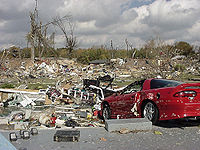
was experiencing technical difficulties at the time, causing some weather radios to not sound an alarm. The tornado killed 25 people; two of the victims died from injuries more than a month after the storm. Damages were estimated at around $85 million.
Ellis Park Racecourse, (a horse racing
Horse racing
Horse racing is an equestrian sport that has a long history. Archaeological records indicate that horse racing occurred in ancient Babylon, Syria, and Egypt. Both chariot and mounted horse racing were events in the ancient Greek Olympics by 648 BC...
facility between Henderson
Henderson, Kentucky
Henderson is a city in Henderson County, Kentucky, United States, along the Ohio River in the western part of the state. The population was 27,952 at the 2010 census. It is part of the Evansville Metropolitan Area often referred to as "Kentuckiana", although "Tri-State Area" or "Tri-State" are more...
and Evansville
Evansville, Indiana
Evansville is the third-largest city in the U.S. state of Indiana and the largest city in Southern Indiana. As of the 2010 census, the city had a total population of 117,429. It is the county seat of Vanderburgh County and the regional hub for both Southwestern Indiana and the...
), was directly hit by the tornado. The track suffered heavy damage; 11 of its 38 barns were destroyed and another 11 were damaged, and several of their racehorses were killed. Extensive tree damage also occurred in the area as the tornado leveled a swath of forests. The worst damage occurred in the southeast side of Evansville, where the Eastbrook Mobile Home Park suffered extreme damage from the tornado. Among the 350 trailers
Mobile home
Mobile homes or static caravans are prefabricated homes built in factories, rather than on site, and then taken to the place where they will be occupied...
in the park, over 100 were flattened and another 125 were severely damaged. Twenty people were killed in the park and another 230 were injured. Electricity
Electricity
Electricity is a general term encompassing a variety of phenomena resulting from the presence and flow of electric charge. These include many easily recognizable phenomena, such as lightning, static electricity, and the flow of electrical current in an electrical wire...
service was cut for over 25,000 customers in the area after the tornado hit.
Severe damage was also reported in Warrick County
Warrick County, Indiana
As of the census of 2000, there were 52,383 people, 19,438 households, and 15,181 families residing in the county. The population density was 136 people per square mile . There were 20,546 housing units at an average density of 54 per square mile...
, where five more people died. The communities of Paradise, DeGonia Springs, Newburgh
Newburgh, Indiana
Newburgh is a town in Ohio Township, Warrick County, Indiana, United States, along the Ohio River. The population was 3,325 at the 2010 census, which also recorded a population of 342,815 for the entire Evansville metropolitan area.-Geography:...
, Boonville
Boonville, Indiana
Boonville is a city in Boon Township, Warrick County, Indiana, United States. The population was 6,834 at the 2000 census. The city is the county seat of Warrick County. Founded in 1818 and named for Jesse Boon, father of Ratliff Boon...
, and Tennyson
Tennyson, Indiana
Tennyson is a town in Skelton Township, Warrick County, Indiana, United States. The population was 279 at the 2010 census.-Geography:Tennyson is located at ....
all sustained major damage, including houses damaged or destroyed, as a result.
Aftermath
Federal Emergency Management Agency
The Federal Emergency Management Agency is an agency of the United States Department of Homeland Security, initially created by Presidential Reorganization Plan No. 1 of 1978 and implemented by two Executive Orders...
(FEMA) noted, "I don't think I've ever seen a community of people come out so quickly to help each other. All communities come together after a disaster, but this one is exceptional." A local telethon helped raise the funds. "Just having a telethon that quickly was amazing," said Gair, "Then to raise that kind of money ... That's unusual."
On August 12, 2006 a granite
Granite
Granite is a common and widely occurring type of intrusive, felsic, igneous rock. Granite usually has a medium- to coarse-grained texture. Occasionally some individual crystals are larger than the groundmass, in which case the texture is known as porphyritic. A granitic rock with a porphyritic...
monument memorial was built at the site, along with a new playground
Playground
A playground or play area is a place with a specific design for children be able to play there. It may be indoors but is typically outdoors...
dedicated to the children lost in the tornado. It was part of a campaign launched by two parents that lost children in the tornado. In addition, Rep.
Indiana General Assembly
The Indiana General Assembly is the state legislature, or legislative branch, of the state of Indiana. It is a bicameral legislature that consists of a lower house, the Indiana House of Representatives, and an upper house, the Indiana Senate...
Phil Hoy
Phil Hoy
George Philip "Phil" Hoy is a former Democratic member of the Indiana House of Representatives, he represented the 77th District from 2004 to 2008.-External links:* Official government website* profile*Follow the Money - Phil Hoy...
introduced a bill called "C.J.'s law" which mandates that manufacturers of mobile homes install an operating weather radio with a separate power outlet in order to alert residents. It was named after victim C.J. Martin, who was two years old. Vanderburgh County also passed legislation toughening safety standards for their 3,100 mobile homes, requiring them to be more securely anchored with additional straps and braces, to try to prevent another tornado disaster.
Ellis Park was rebuilt and reopened on June 1, 2006, for training. The first races at the rebuilt facility were held on July 19, 2006.
Local television station
Television station
A television station is a business, organisation or other such as an amateur television operator that transmits content over terrestrial television. A television transmission can be by analog television signals or, more recently, by digital television. Broadcast television systems standards are...
WEHT
WEHT
WEHT is the ABC-affiliated television station for the Tri-State area of Southwestern Indiana, Northwestern Kentucky and Southeastern Illinois; it is owned by Nexstar Broadcasting Group under a shared services agreement with independent station WTVW...
began a campaign after the tornado to provide weather radios to tornado victims for free, and to all for a discounted price. Even WEHT's competitors have now posted how to program a weather radio on their websites. This program has since spread to many different areas of the country.
Habitat of Humanity's Evansville Chapter launched construction of "Operation Home Again," the New Haven Subdivision, which are new homes dedicated to the survivors of the tornado at Green River Road and Fickas Road. When complete the subdivision will have 55 homes, a playground, and a park. There are four streets in the subdivision – Inspiration Street, Healing Street, Promise Street, and Belief Street.
Fatalities
| State | Total | County | County total |
|---|---|---|---|
| Indiana Indiana Indiana is a US state, admitted to the United States as the 19th on December 11, 1816. It is located in the Midwestern United States and Great Lakes Region. With 6,483,802 residents, the state is ranked 15th in population and 16th in population density. Indiana is ranked 38th in land area and is... |
25 | Vanderburgh Vanderburgh County, Indiana As of the census of 2000, there were 171,922 people, 70,623 households, and 44,421 families residing in the county. The population density was 733 people per square mile . There were 76,300 housing units at an average density of 325 per square mile... |
21 |
| Warrick Warrick County, Indiana As of the census of 2000, there were 52,383 people, 19,438 households, and 15,181 families residing in the county. The population density was 136 people per square mile . There were 20,546 housing units at an average density of 54 per square mile... |
4 | ||
| Totals | 25 | ||
| All deaths were tornado-related | |||
See also
- List of North American tornadoes and tornado outbreaks
- Tornadoes of 2005Tornadoes of 2005This page documents the tornadoes and tornado outbreaks of 2005, primarily in the United States. Most tornadoes form in the U.S., although some events may take place internationally, particularly in parts of neighboring southern Canada during the summer season.-Synopsis:The first half of 2005 was...