
Sharp County, Arkansas
Encyclopedia
Sharp County is a county
located in the U.S. state
of Arkansas
. As of 2010, the population was 17,264. The county seat
is Ash Flat
. The county was formed on July 18, 1868, and named for Ephraim Sharp, a state legislator from the area. It is an alcohol prohibition or dry county
.
The former Sharp Citizen newspaper published by Joseph H. Weston
from 1972-1978 led to a change in Arkansas libel law.
 As of the census
of 2000, there were 17,119 people, 7,211 households, and 5,141 families residing in the county. The population density
was 28 people per square mile (11/km²). There were 9,342 housing units at an average density of 16 per square mile (6/km²). The racial makeup of the county was 97.14% White
, 0.49% Black
or African American
, 0.68% Native American
, 0.12% Asian
, 0.02% Pacific Islander
, 0.16% from other races
, and 1.39% from two or more races. 0.98% of the population were Hispanic
or Latino
of any race.
There were 7,211 households out of which 25.80% had children under the age of 18 living with them, 59.90% were married couples
living together, 8.10% had a female householder with no husband present, and 28.70% were non-families. 25.60% of all households were made up of individuals and 14.40% had someone living alone who was 65 years of age or older. The average household size was 2.34 and the average family size was 2.79.
In the county the population was spread out with 21.90% under the age of 18, 6.30% from 18 to 24, 22.80% from 25 to 44, 25.50% from 45 to 64, and 23.60% who were 65 years of age or older. The median age was 44 years. For every 100 females there were 92.40 males. For every 100 females age 18 and over, there were 90.20 males.
The median income for a household in the county was $25,152, and the median income for a family was $29,691. Males had a median income of $23,329 versus $16,884 for females. The per capita income
for the county was $14,143. About 13.20% of families and 18.20% of the population were below the poverty line, including 25.40% of those under age 18 and 13.20% of those age 65 or over.
County (United States)
In the United States, a county is a geographic subdivision of a state , usually assigned some governmental authority. The term "county" is used in 48 of the 50 states; Louisiana is divided into parishes and Alaska into boroughs. Parishes and boroughs are called "county-equivalents" by the U.S...
located in the U.S. state
U.S. state
A U.S. state is any one of the 50 federated states of the United States of America that share sovereignty with the federal government. Because of this shared sovereignty, an American is a citizen both of the federal entity and of his or her state of domicile. Four states use the official title of...
of Arkansas
Arkansas
Arkansas is a state located in the southern region of the United States. Its name is an Algonquian name of the Quapaw Indians. Arkansas shares borders with six states , and its eastern border is largely defined by the Mississippi River...
. As of 2010, the population was 17,264. The county seat
County seat
A county seat is an administrative center, or seat of government, for a county or civil parish. The term is primarily used in the United States....
is Ash Flat
Ash Flat, Arkansas
Ash Flat is a city in Fulton and Sharp counties in the U.S. state of Arkansas. The population was 977 at the 2000 census. The city is the county seat of Sharp County.-Geography:Ash Flat is located at ....
. The county was formed on July 18, 1868, and named for Ephraim Sharp, a state legislator from the area. It is an alcohol prohibition or dry county
Dry county
A dry county is a county in the United States whose government forbids the sale of alcoholic beverages. Some prohibit off-premises sale, some prohibit on-premises sale, and some prohibit both. Hundreds of dry counties exist across the United States, almost all of them in the South...
.
The former Sharp Citizen newspaper published by Joseph H. Weston
Joseph H. Weston
Joseph H. Weston was a controversial newspaper editor in Cave City in Sharp County in northern Arkansas, whose work led to a change in his state's libel law....
from 1972-1978 led to a change in Arkansas libel law.
Geography
According to the 2000 census, the county has a total area of 606.35 square miles (1,570.4 km²), of which 604.35 square miles (1,565.3 km²) (or 99.67%) is land and 1.99 square miles (5.2 km²) (or 0.33%) is water.Major highways
 U.S. Highway 62
 U.S. Highway 63
 U.S. Highway 167
 U.S. Highway 412
 Highway 56
 Highway 58
 Highway 175
Adjacent counties
- Oregon CountyOregon County, MissouriOregon County is a county located in South Central Missouri in the United States. As of the 2000 U.S. Census, the county's population was 10,344. A 2008 estimate, however, showed the population to be 10,264. Its county seat is Alton...
, MissouriMissouriMissouri is a US state located in the Midwestern United States, bordered by Iowa, Illinois, Kentucky, Tennessee, Arkansas, Oklahoma, Kansas and Nebraska. With a 2010 population of 5,988,927, Missouri is the 18th most populous state in the nation and the fifth most populous in the Midwest. It...
(north) - Randolph County (northeast)
- Lawrence County (southeast)
- Independence County (south)
- Izard County (southwest)
- Fulton County (northwest)
Demographics
Census
A census is the procedure of systematically acquiring and recording information about the members of a given population. It is a regularly occurring and official count of a particular population. The term is used mostly in connection with national population and housing censuses; other common...
of 2000, there were 17,119 people, 7,211 households, and 5,141 families residing in the county. The population density
Population density
Population density is a measurement of population per unit area or unit volume. It is frequently applied to living organisms, and particularly to humans...
was 28 people per square mile (11/km²). There were 9,342 housing units at an average density of 16 per square mile (6/km²). The racial makeup of the county was 97.14% White
Race (United States Census)
Race and ethnicity in the United States Census, as defined by the Federal Office of Management and Budget and the United States Census Bureau, are self-identification data items in which residents choose the race or races with which they most closely identify, and indicate whether or not they are...
, 0.49% Black
Race (United States Census)
Race and ethnicity in the United States Census, as defined by the Federal Office of Management and Budget and the United States Census Bureau, are self-identification data items in which residents choose the race or races with which they most closely identify, and indicate whether or not they are...
or African American
Race (United States Census)
Race and ethnicity in the United States Census, as defined by the Federal Office of Management and Budget and the United States Census Bureau, are self-identification data items in which residents choose the race or races with which they most closely identify, and indicate whether or not they are...
, 0.68% Native American
Race (United States Census)
Race and ethnicity in the United States Census, as defined by the Federal Office of Management and Budget and the United States Census Bureau, are self-identification data items in which residents choose the race or races with which they most closely identify, and indicate whether or not they are...
, 0.12% Asian
Race (United States Census)
Race and ethnicity in the United States Census, as defined by the Federal Office of Management and Budget and the United States Census Bureau, are self-identification data items in which residents choose the race or races with which they most closely identify, and indicate whether or not they are...
, 0.02% Pacific Islander
Race (United States Census)
Race and ethnicity in the United States Census, as defined by the Federal Office of Management and Budget and the United States Census Bureau, are self-identification data items in which residents choose the race or races with which they most closely identify, and indicate whether or not they are...
, 0.16% from other races
Race (United States Census)
Race and ethnicity in the United States Census, as defined by the Federal Office of Management and Budget and the United States Census Bureau, are self-identification data items in which residents choose the race or races with which they most closely identify, and indicate whether or not they are...
, and 1.39% from two or more races. 0.98% of the population were Hispanic
Race (United States Census)
Race and ethnicity in the United States Census, as defined by the Federal Office of Management and Budget and the United States Census Bureau, are self-identification data items in which residents choose the race or races with which they most closely identify, and indicate whether or not they are...
or Latino
Race (United States Census)
Race and ethnicity in the United States Census, as defined by the Federal Office of Management and Budget and the United States Census Bureau, are self-identification data items in which residents choose the race or races with which they most closely identify, and indicate whether or not they are...
of any race.
There were 7,211 households out of which 25.80% had children under the age of 18 living with them, 59.90% were married couples
Marriage
Marriage is a social union or legal contract between people that creates kinship. It is an institution in which interpersonal relationships, usually intimate and sexual, are acknowledged in a variety of ways, depending on the culture or subculture in which it is found...
living together, 8.10% had a female householder with no husband present, and 28.70% were non-families. 25.60% of all households were made up of individuals and 14.40% had someone living alone who was 65 years of age or older. The average household size was 2.34 and the average family size was 2.79.
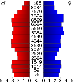
In the county the population was spread out with 21.90% under the age of 18, 6.30% from 18 to 24, 22.80% from 25 to 44, 25.50% from 45 to 64, and 23.60% who were 65 years of age or older. The median age was 44 years. For every 100 females there were 92.40 males. For every 100 females age 18 and over, there were 90.20 males.
The median income for a household in the county was $25,152, and the median income for a family was $29,691. Males had a median income of $23,329 versus $16,884 for females. The per capita income
Per capita income
Per capita income or income per person is a measure of mean income within an economic aggregate, such as a country or city. It is calculated by taking a measure of all sources of income in the aggregate and dividing it by the total population...
for the county was $14,143. About 13.20% of families and 18.20% of the population were below the poverty line, including 25.40% of those under age 18 and 13.20% of those age 65 or over.
Cities, towns and communities
|
Hardy, Arkansas Hardy is a city in Sharp and Fulton counties in the U.S. state of Arkansas. The population was 578 at the 2000 census.-Geography:Hardy is located at .The Spring River, which begins in Mammoth Spring, flows through Hardy... Highland, Arkansas Highland is a city in Sharp County, Arkansas, United States. The population was 986 at the 2000 census.-Geography:Highland is located at .... Horseshoe Bend, Arkansas Horseshoe Bend is a city in Fulton, Izard, and Sharp counties in the U.S. state of Arkansas. The population was 2,278 at the 2000 census.-Geography:Horseshoe Bend is located at .... Ozark Acres, Arkansas Ozark Acres is an unincorporated Suburban Improvement District , a Deeded Community in Sharp County, Arkansas, United States.-Geography:Ozark Acres is located at .... |
Poughkeepsie, Arkansas Poughkeepsie is an unincorporated community in Sharp County, Arkansas, United States. The community is located in south central Sharp County, near the Strawberry River.- External links :*... Sidney, Arkansas Sidney is a town in Sharp County, Arkansas, United States. The population was 275 at the 2000 census.-Geography:Sidney is located at .According to the United States Census Bureau, the town has a total area of , all land.... Williford, Arkansas Williford is a town in Sharp County, Arkansas, United States. The population was 63 at the 2000 census.-Geography:Williford is located at .... |
Townships
- Big Creek
- Cave (Cave CityCave City, ArkansasCave City is a city in Independence and Sharp counties in the U.S. state of Arkansas. The population was 1,946 at the 2000 census. The city was named for a large cave underneath the Crystal River Tourist Camp, which is the oldest motor court in Arkansas...
) - Cherokee (most of Cherokee VillageCherokee Village, ArkansasCherokee Village is a city in Fulton and Sharp counties in the U.S. state of Arkansas. The population was 4,807 at the 2007 census.-Geography:Cherokee Village is located at ....
, small part of HighlandHighland, ArkansasHighland is a city in Sharp County, Arkansas, United States. The population was 986 at the 2000 census.-Geography:Highland is located at ....
) - Davidson
- East Sullivan
- Hardy (most of HardyHardy, ArkansasHardy is a city in Sharp and Fulton counties in the U.S. state of Arkansas. The population was 578 at the 2000 census.-Geography:Hardy is located at .The Spring River, which begins in Mammoth Spring, flows through Hardy...
) - Highland (most of HighlandHighland, ArkansasHighland is a city in Sharp County, Arkansas, United States. The population was 986 at the 2000 census.-Geography:Highland is located at ....
) - Jackson (WillifordWilliford, ArkansasWilliford is a town in Sharp County, Arkansas, United States. The population was 63 at the 2000 census.-Geography:Williford is located at ....
) - Lave Creek
- Lower North
- Morgan
- North Big Rock
- North Lebanon
- Ozark
- Piney Fork (Evening ShadeEvening Shade, ArkansasEvening Shade is a town in Sharp County, Arkansas, United States. The population was 465 at the 2000 census. The town was fictionalized in a television situation comedy starring Burt Reynolds and entitled Evening Shade in the U.S.-Geography:...
) - Richwoods
- Scott
- South Big Rock
- South Union
- Strawberry
- Upper North
- Washington
- West Sullivan (most of SidenySidney, ArkansasSidney is a town in Sharp County, Arkansas, United States. The population was 275 at the 2000 census.-Geography:Sidney is located at .According to the United States Census Bureau, the town has a total area of , all land....
)