

Yavapai people
Encyclopedia
Yavapai are an indigenous people in Arizona
. Historically, the Yavapai were divided into four geographical bands that considered themselves separate peoples: the Tolkapaya, or Western Yavapai, the Yavapé, or Northwestern Yavapai, the Kwevkapaya, or Southeastern Yavapai, and Wipukpa, or Northeastern Yavapai - Verde Valley Yavapai. Another Yavapai band was the Matakwadapaya. This group is believed to have mixed with the Mohave and Quechan and no longer exists, but several Mohave and Quechan families trace their family history to Yavapai roots. The Yavapai have much in common with their neighbors the Havasupai, the Hualapai
, and the Athabascan Apache
. Often, Yavapai were mistaken as Apache by American
settlers, variously being referred to as "Apache-Mohave" or "Tonto-Apache". Before the 1860s, when settlers began exploring for gold in the area, the Yavapai occupied an area of approximately 20,000 mi² (51800 km²) bordering the San Francisco Peaks
on the north, the Pinaleno Mountains
and Mazatzal Mountains
on the southeast, and Martinez Lake
and the Colorado River
at the point where Lake Havasu
is now on the west, and almost to the Gila River
and the Salt River
to the south.
, the Yavapai were mainly hunter-gatherers, following an annual round, migrating to different areas to follow the ripening of different edible plants, although some tribes supplemented this with small scale cultivation of the "three sisters
": (maize
, squash, and bean
s) in fertile streambeds. In particular, the Tolkepaya, who lived in lands that were less supportive of food gathering, turned to agriculture more than other Yavapai, despite the fact that their land was also less supportive of agriculture. In turn, Tolkepaya often traded items such as animal skins, baskets, and agave
to Quechan
groups for food. The main plant foods gathered were walnuts, saquaro fruits
, juniper berries
, acorn
s, sunflower seed
s, manzanita berries
, hackberries, the bulbs of the Quamash
, and the greens of the Lamb's quarters
, Scrophularia
, and Lupinus plants. Agave was the most crucial harvest, being the only plant food available from late fall through early spring. The hearts of the plant were roasted in stone-lined pits, and could be stored for later use. Primary animals hunted were deer
, rabbit
, jackrabbit, quail
, and woodrat. Fish and water-borne birds were eschewed by most Yavapai groups, though some groups of Tolkepaya began eating fish after contact with their Quechan neighbors.
, McDowell Mountains
, Red Mountain near Fort McDowell, Mingus Mountain-(Black Hills) near Camp Verde, and Granite Mountain
near Prescott are all believed to be inhabited by these spirits. The Yavapai also believe that the Gaahkaka dwell in the caves of Montezuma's Castle and Montezuma's Well in Camp Verde. Often, people claim to see these spirits or hear them singing at night on the Fort McDowell reservation and describe them as little kids. The Yavapai version of the dance is very different than the Apache.
The Bird dance is a dance shared within the Yuman culture. This dance represents nature. Often we see birds hopping around and making noises. When the girls are dancing they represent the bird doing those things. The songs tell of nature such as the mountains, land, river, trees, and animals.
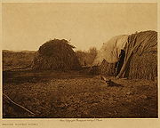 The Yavapai lived in brush shelters called Wham-boo nayva's (Wom-boo-nya-va). In summer, shelters were often simple lean-tos without walls. During winter months, closed huts (called uwas) would be built of ocotillo
branches or other wood and covered with animal skins, grasses, bark, and/or dirt, though in the Colorado River area, Tolkepaya built uwatamarva, which was a rectangular hut, that had dirt piled up against its sides, and a flat roof. Other shelter was often sought in caves or abandoned pueblo
s to escape the cold.
fruit harvest, and hunting of rabbits and woodrats.
In winter, camps were formed of larger groups consisting of several families that broke up in time for the spring harvest.
The Yavapai divided into subsequent four groups:
Both in the Walkamepa and Wikedjasapa following clans were represented and shared mostly overlapping territories:
and most of the Yavapai bands west of it. The Wipukepa tribal areas in the San Francisco Peaks
, along the Upper Verde River
, Oak Creek Canyon
and Fossil Creek
overlapped with those of the Northern Tonto Apache. Likewise the Kwevkepaya shared hunting and gathering grounds east of the Verde River, along Fossil Creek, East Verde River
, Salt River and in the Superstition Mountains
, Sierra Ancha
and Pinaleno Mountains
with Southern Tonto Apache and bands of the San Carlos Apache. Therefore they formed bilingual mixed-tribal band
s, whose members could not be readily distinguished by outsiders (Americans, Mexicans or Spanish) except by their languages. The Apache spoke the Tonto dialect of the Western Apache language
(Ndee biyati' / Nnee biyati) and the Yavapai spoke the Yavapai language
, a branch of Upland Yuman. Living together in common rancherias, whether they considered themselves to be Apaches or Yavapais, depended on their “Mother tongue” as the origin of the matrilineal society, directed by the mother. The ethnic Europeans referred to the Yavapai and Apache together as Tonto or Tonto Apache. The peoples raided and warred together against enemy tribes such as the Tohono O'odham
and the Akimel O'odham. Scholars cannot tell from records whether the writers of the time, when using the term Tonto Apache, were referring to Yavapai or Apache, or those mixed bands. In addition, the Europeans often referred to the Wipukepa and Kwevkepaya incorrectly as the Yavapai Apache or Yuma Apache. To further confusion, the Europeans referred to the Tolkepaya, the southwestern group of Yavapai, and the Hualapai
(who belonged to the Upland Yuma Peoples) as Yuma Apache or Mohave Apache.
 Yavapai believe that their people originated "in the beginning", or "many years ago", when either a tree, or a maize plant sprouted from the ground in what is now Montezuma Well
, bringing the Yavapai into the world. Most archeologists agree that the Yavapai originated from Patayan
groups who migrated east from the Colorado River region to become Upland Yumans, and then splitting off to become Yavapai somewhere around 1300 AD.
Warfare was not uncommon in the Yavapai world, and alliances were often formed for security. Wipukepa and Kwevkepaya bands formed alliances with Western Apache
bands, to attack and defend against raids by Pima
and Maricopa bands from the south. Because of the greater strength had by the Pima/Maricopa, Yavapai/Apache raids were generally smaller quicker raids, followed by a retreat to avoid counter-attack. Yavapai lands were defended against Pima incursions when Pima bands would move into Yavapai lands to harvest saguaro fruits.
To the north and northwest, Wipukepa and Yavapé bands had off and on relations with the Pai people throughout most of their history. Though Pai and Yavapai both used Upland Yuman dialects, and a common cultural history, both had tales of the origins of a dispute that separated the peoples from each other. According to Pai myth, the dispute began with a "mudball fight between children". It is believed that this split occurred around 1750.
The last big battle between the Colorado-Gila River alliances took place in August 1857, when about 100 Yavapai, Quechan
, and Mohave warriors surprise attacked a settlement of Maricopa near Pima Butte. After overwhelming the Maricopa, the Yavapai left, to have Pima supplied with guns and horses from US troops show up and rout the remaining Mohave and Quechans.
, who was brought to Jerome Mountain by Hopi
guides in 1583, looking for gold
. However, de Espejo was disappointed to only find copper
. In 1598, Hopi brought Marcos Farfán de los Godos and his group to the same mines, to their excitement. Farfán referred to the Yavapai as "cruzados" because of the crosses worn on their heads. A group led by Juan de Oñate
went through Yavapai lands in 1598, and again in 1604-5, looking for a route to the sea that Yavapai had told them about. After this, no other European contact was made for more than 200 years.
In the intervening time, despite little or no direct contact with Europeans, but contact with other tribes with more European contact, Yavapai did begin to incorporate elements of European culture into their own, such as livestock and plant crops, modern tools and weaponry, as well as elements of Christianity
. Though their de-centralized communities, and less contact with Europeans helped to make this less of an issue than it was for many neighboring tribes, to their detriment, smallpox
also spread through their communities. It is estimated that around 25% of the population died as a result of smallpox in the 17th and 18th centuries. They also began to change methods of warfare, diplomacy, and trade. Livestock raiding, either from other tribes such as the Maricopa, or from Spanish
settlements to their south, became a supplement to the Yavapai economy. As well, raids often yielded human captives, to be traded as slaves to Spaniards in trade for goods.
In the 1820s, beaver trappers, having depleted the beaver population of the Rocky Mountains
, began entering Yavapai territory, trapping beaver along the Salt, Gila
, and Bill Williams River
s. When Kit Carson
and Ewing Young
led a group through the territory in 1829, the group was "nightly harassed...", and had traps stolen, and horses and mules killed.
Following the declaration of war against Mexico in May 1846, and especially after the claim by the US of southwest lands in the Treaty of Guadalupe-Hidalgo, military incursions into Yavapai territory greatly increased. After gold was discovered in California in 1849, more White emigrants passed through Yavapai territory than ever had before. Despite the thousands of emigrants passing through their territory, Yavapai rarely made contact with Whites.
In 1851, Yavapai's attacked the family of Olive Oatman
along the Gila River, in the massacre Oatman and her younger sister were abducted and made slaves until being sold to the Mohave.
Eventually Oatman was rescued by the help of her brother six years later in 1856.
The first fighting between US troops and Yavapai came in early 1852, when Tolkepaya joined with their Quechan neighbors to defend against Major Samuel Heintzelman
over a Quechan ferry crossing on the Colorado River. The Quechans used the ferry crossing to transport settlers over the river, into California, but after killing a group led by John Glanton
, who had taken over the crossing, the government decided to burn the fields of the Quechans, and take control of the crossing.
According to Thomas Sweeney, Tolkepaya would tell US officers they encountered in Quechan territory, that they had a 30-day march to their own territory, as a means of discouraging US encroachment on their land.
and Mary Ann
were later sold to Mojaves as slaves. The story was widely published, and increased White settlers' fears of attack in Arizona.
), it set off a chain of events that would have White settlements along the Hassayampa
and Agua Fria Rivers, the nearby valleys, as well as in Prescott, and Fort Whipple
would be built, all by the end of the year, and all in traditional Yavapai territory.
 With the Mohave people's power greatly diminished, Tolkepaya saw that they needed to make new alliances to protect their safety. In April 1863, Quashackama, a well-known Tolkepaya, met with Arizona Territory superintendent of Indian affairs Charles Poston
, along with representatives of the Pimas, Mohaves, Maricopas and Chemehuevi
s, at Fort Yuma
, to sign an agreement intended "to promote the commerce in safety between the before mentioned tribes and the Americans." However, the agreement was not an official treaty, so therefore not legally binding in any way.
Despite this, the growing numbers of settlers (very quickly outnumbering Yavapai) began to call for the government to do something about the people occupying the land that they wanted to occupy and exploit themselves. The editor of a local newspaper, the Arizona Miner, said "Extermination is our only hope, and the sooner it is accomplished the better."
Early in January 1864, the Yavapai raided a number of ranches that supplied cattle to the miners in the Prescott and Agua Fria area. As a result of this and a series of recent killings, a preemptive attack was organized to discourage future depredations. Therefore, a group of well-armed volunteers were quickly outfitted with King S. Woolsey as their leader. Their mission was to track the raiding party back to their rancheria. What followed was an infamous footnote in Arizona history known today as the Bloody Tanks incident.
According to Braatz, "In December 1864, soldiers from Fort Whipple attacked two nearby Yavapé camps, killing 14 and wounding seven." The following month, Fort Whipple soldiers attacked another group of Yavapé, this time killing twenty-eight people, including their headman, Hoseckrua. Included in the group were employees of Prescott's US Indian agent John Dunn.
In 1864, Arizona Territory
Governor John Goodwin
advised the territorial legislature that all tribes be subdued and sent to reservations. The same year, a dispatch from the US Army stated "All Apache [Yavapai were routinely lumped in with their neighboring Apache] Indians in that territory are hostile, and all Apache men large enough to bear arms who may be encountered in Arizona will be slain whenever met, unless they give themselves up as prisoners."
Not long after, in retaliation for the murder of a Pai headman by Americans, a group of Pai attacked some wagon trains, and closed the road between Prescott and Fort Mohave to all traffic. In response, the US Army declared all Indians in lands beyond 75 miles (121 km) east of the Colorado River (the great majority of traditional Yavapai territory) to be "hostile" and "subject to extermination".
On November 5, 1871 the ambush of the Wickenburg stage-the Wickenburg massacre
in which a driver and five of seven passengers killed led to the relocation of the Yavapai from Prescott to San Carlos Reservation in February 1875.
 In December 1872, Colonel George Crook
used Apache
scouts to find a cave in Salt River Canyon
that was being used by Kwevkepaya to mount attacks on White settlers. On December 28, accompanied by 100 Pima scouts, Captain William Brown led 120 of Crook's men to a siege of the cave
. 110 Kwevkepaya were trapped in the cave, when Brown ordered the soldiers to fire at the roof of the cave, causing rock fragments and lead shrapnel to rain down on the Kwevkepaya. Having nowhere else to go, the besieged gathered around the mouth of the cave, where soldiers (accompanied by Crook) pushed boulders onto them from above, killing 76 of the group. The survivors were taken to Camp Grant as prisoners. The Yavapai were so demoralized by this and other actions by Crook that they surrendered at Camp Verde
, on April 6, 1873. In 1925, a group of Yavapai from the Fort McDowell Reservation, along with a Maricopa County Sheriff, collected the bones from the cave, and interred them at the Fort McDowell cemetery.
In 1886, many Yavapai joined in campaigns by the US Army, as scouts, against Geronimo
and other Chiricahua Apache.
, on the Verde River
near Camp Verde, the Yavapai there began to construct irrigation systems (including a five-mile (8 km) long ditch) that functioned well enough to reap sufficient harvests, making the tribe relatively self-sufficient. But contractors that worked with the government to supply the reservations were disappointed, and petitioned to have the reservation revoked. The government complied, and in March 1875, the government closed the reservation, and marched the residents 180 miles (289.7 km) to the San Carlos reservation
. More than 100 Yavapai died during the winter trek.
By the early 1900s, Yavapai were drifting away from the San Carlos Reservation, and were requesting permission to live on the grounds of the original Camp Verde Reservation. In 1910, 40 acres (161,874 m²) was set aside as the Camp Verde Indian Reservation, and in the following decade added 248 acres (1,003,621 m²) in two parcels, which became the Middle Verde Indian Reservation. These two reservations were combined in 1937, to form the Camp Verde Yavapai-Apache tribe. Today, the reservation spans 665 acres (2.7 km²), in four separate locales. Tourism contributes greatly to the economy of the tribe, due largely to the presence of many preserved sites, including the Montezuma Castle National Monument
. The Yavapai-Apache Nation is the amalgamation of two historically distinct Tribes both of whom occupied the Upper Verde prior to European invasion. The Tonto Apache, calling themselves Dilzhe'e, utilized the lands to the north, east and south; while the Wipukepa or Northeastern Yavapai were using country to the north, the west and the south. It was the Upper Verde where they overlapped.
 The Yavapai reservation
in Prescott was established in 1935, originally consisting of just 75 acres (303,514.5 m²) of land formerly occupied by the Fort Whipple Military Reserve. In 1956, an additional 1320 acres (5 km²) was added. Succeeding the tribe's first chief, Sam Jimulla, his wife Viola
became the first female chieftess of a North American tribe. Today, the tribe consists of 159 official members.
is located within Maricopa County approximately 20 miles from Phoenix the reservation came into existence when Theodore Roosevelt had Fort McDowell declared a 40 square miles (103.6 km²) reservation in 1903, but by 1910, the Office of Indian Affairs was attempting to relocate the residents, to open up the area, and water rights to other interests. A delegation of Yavapai testified to a Congressional Committee against this, and won. Today, the tribal community consists of 900 members, 600 of whom live on the reservation and the remanning 300 which live off the reservation. The Kwevikopaya or Southeastern Yavapai on Fort McDowell Reservation call themselves Abaja - ″The People” therefore some anthropologists and linguists believe, that the name Apache
for the various Southern Athabascan peoples derives from the self-designation of the Yavapai. The population of Fort McDowell consists of two different peoples, the Kwevikopaya Yavapai and the Dilzhe'e Apache or Tonto Apache, who historically often intermarried, formed mixed bilingual bands and were allies against enemy tribes and white settlers.
area, in the early 1970s Arizona officials proposed to build a dam
at the point where the Verde
and Salt Rivers
meet. The dam would have flooded two-thirds of the 24000 acres (97 km²) reservation. In return, the members of the tribe (at the time consisting of 425 members) were offered homes and cash settlements. But in 1976, the tribe rejected the offer by a vote of 61%, claiming that the tribe would be effectively disbanded by the move. In 1981, after much petitioning of the US government, and a three day march by approximately 100 Yavapai, the plan to build the dam was withdrawn.
The language includes three dialects, which have been referred to as Western, Northeastern and Southeastern, as well as Prescott, Verde Valley, and Tolkapaya.
Kwevkepaya leader
Wipukepa leader
Yavapé leader
Tolkepaya leader
0910037388
Arizona
Arizona ; is a state located in the southwestern region of the United States. It is also part of the western United States and the mountain west. The capital and largest city is Phoenix...
. Historically, the Yavapai were divided into four geographical bands that considered themselves separate peoples: the Tolkapaya, or Western Yavapai, the Yavapé, or Northwestern Yavapai, the Kwevkapaya, or Southeastern Yavapai, and Wipukpa, or Northeastern Yavapai - Verde Valley Yavapai. Another Yavapai band was the Matakwadapaya. This group is believed to have mixed with the Mohave and Quechan and no longer exists, but several Mohave and Quechan families trace their family history to Yavapai roots. The Yavapai have much in common with their neighbors the Havasupai, the Hualapai
Hualapai
The Hualapai or Walapai are a tribe of Native Americans who live in the mountains of northwestern Arizona, United States. The name is derived from "hwa:l," the Hualapai word for ponderosa pine, "Hualapai" meaning "people of the ponderosa pine"...
, and the Athabascan Apache
Apache
Apache is the collective term for several culturally related groups of Native Americans in the United States originally from the Southwest United States. These indigenous peoples of North America speak a Southern Athabaskan language, which is related linguistically to the languages of Athabaskan...
. Often, Yavapai were mistaken as Apache by American
United States
The United States of America is a federal constitutional republic comprising fifty states and a federal district...
settlers, variously being referred to as "Apache-Mohave" or "Tonto-Apache". Before the 1860s, when settlers began exploring for gold in the area, the Yavapai occupied an area of approximately 20,000 mi² (51800 km²) bordering the San Francisco Peaks
San Francisco Peaks
The San Francisco Peaks are a volcanic mountain range located in north central Arizona, just north of Flagstaff.The highest summit in the range, Humphreys Peak, is the highest point in the state of Arizona at in elevation. The San Francisco Peaks are the remains of an eroded stratovolcano...
on the north, the Pinaleno Mountains
Pinaleno Mountains
The Pinaleño Mountains, or the Pinal Mountains, are a remote mountain range in southeastern Arizona. They have over of vertical relief, more than any other range in the state. The mountains are surrounded by the Sonoran-Chihuahuan Desert. Subalpine forests cover the higher elevations...
and Mazatzal Mountains
Mazatzal Mountains
The Mazatzal Mountains are a mountain range in south central Arizona, about 30–45 miles northeast of Phoenix and the Phoenix metropolitan area. The origin of the name remains obscure but one possibility is that it is from the Aztec language meaning "place of the deer"...
on the southeast, and Martinez Lake
Martinez Lake
Martinez Lake is a lake in the southwestern corner of the U.S. state of Arizona, about 60 miles north of Yuma, Arizona on the Lower Colorado River...
and the Colorado River
Colorado River
The Colorado River , is a river in the Southwestern United States and northwestern Mexico, approximately long, draining a part of the arid regions on the western slope of the Rocky Mountains. The watershed of the Colorado River covers in parts of seven U.S. states and two Mexican states...
at the point where Lake Havasu
Lake Havasu
Lake Havasu is a large reservoir behind Parker Dam on the Colorado River, on the border between California and Arizona. Lake Havasu City sits on the lake's eastern shore. The lake has a capacity of . The concrete arch dam was built by the United States Bureau of Reclamation between 1934 and 1938...
is now on the west, and almost to the Gila River
Gila River
The Gila River is a tributary of the Colorado River, 650 miles long, in the southwestern states of New Mexico and Arizona.-Description:...
and the Salt River
Salt River (Arizona)
The Salt River is a stream in the U.S. state of Arizona. It is the largest tributary of the Gila River. The river is about long. Its drainage basin is about large. The longest of the Salt River's many tributaries is the Verde River...
to the south.
Subsistence
Before being confined to reservationsIndian reservation
An American Indian reservation is an area of land managed by a Native American tribe under the United States Department of the Interior's Bureau of Indian Affairs...
, the Yavapai were mainly hunter-gatherers, following an annual round, migrating to different areas to follow the ripening of different edible plants, although some tribes supplemented this with small scale cultivation of the "three sisters
Three Sisters (agriculture)
The Three Sisters are the three main agricultural crops of various Native American groups in North America: squash, maize, and climbing beans ....
": (maize
Maize
Maize known in many English-speaking countries as corn or mielie/mealie, is a grain domesticated by indigenous peoples in Mesoamerica in prehistoric times. The leafy stalk produces ears which contain seeds called kernels. Though technically a grain, maize kernels are used in cooking as a vegetable...
, squash, and bean
Bean
Bean is a common name for large plant seeds of several genera of the family Fabaceae used for human food or animal feed....
s) in fertile streambeds. In particular, the Tolkepaya, who lived in lands that were less supportive of food gathering, turned to agriculture more than other Yavapai, despite the fact that their land was also less supportive of agriculture. In turn, Tolkepaya often traded items such as animal skins, baskets, and agave
Agave
Agave is a genus of monocots. The plants are perennial, but each rosette flowers once and then dies ; they are commonly known as the century plant....
to Quechan
Quechan
The Quechan are a Native American tribe who live on the Fort Yuma Indian Reservation on the lower Colorado River in Arizona and California just north of the border with Mexico...
groups for food. The main plant foods gathered were walnuts, saquaro fruits
Saguaro
The saguaro is a large, tree-sized cactus species in the monotypic genus Carnegiea. It is native to the Sonoran Desert in the U.S. state of Arizona, the Mexican state of Sonora, a small part of Baja California in the San Felipe Desert and an extremely small area of California, U.S...
, juniper berries
Juniper berry
A juniper berry is the female seed cone produced by the various species of junipers. It is not a true berry but a cone with unusually fleshy and merged scales, which give it a berry-like appearance. The cones from a handful of species, especially Juniperus communis, are used as a spice,...
, acorn
Acorn
The acorn, or oak nut, is the nut of the oaks and their close relatives . It usually contains a single seed , enclosed in a tough, leathery shell, and borne in a cup-shaped cupule. Acorns vary from 1–6 cm long and 0.8–4 cm broad...
s, sunflower seed
Sunflower seed
The sunflower seed is the fruit of the sunflower . The term "sunflower seed" is actually a misnomer when applied to the seed in its pericarp . Botanically speaking, it is more properly referred to as an achene. When dehulled, the edible remainder is called the sunflower kernel.There are three types...
s, manzanita berries
Manzanita
Manzanita is a common name for many species of the genus Arctostaphylos. They are evergreen shrubs or small trees present in the chaparral biome of western North America, where they occur from southern British Columbia, Washington to California, Arizona and New Mexico in the United States, and...
, hackberries, the bulbs of the Quamash
Quamash
Quamash , also known as Small Camas, is a perennial herb. It is one species of the genus Camassia and is native to western North America in large areas of southern Canada and the northwestern United States, from British Columbia and Alberta to California and east from Washington state to Montana...
, and the greens of the Lamb's quarters
Chenopodium berlandieri
Chenopodium berlandieri, also known by the common names pitseed goosefoot, huauzontle, and lambsquarters, is an annual herbaceous plant in the goosefoot family....
, Scrophularia
Scrophularia
The genus Scrophularia of the family Scrophulariaceae comprises about 200 species of herbaceous flowering plants commonly known as figworts. Species of Scrophularia all share square stems, opposite leaves and open two-lipped flowers forming clusters at the end of their stems...
, and Lupinus plants. Agave was the most crucial harvest, being the only plant food available from late fall through early spring. The hearts of the plant were roasted in stone-lined pits, and could be stored for later use. Primary animals hunted were deer
Deer
Deer are the ruminant mammals forming the family Cervidae. Species in the Cervidae family include white-tailed deer, elk, moose, red deer, reindeer, fallow deer, roe deer and chital. Male deer of all species and female reindeer grow and shed new antlers each year...
, rabbit
Rabbit
Rabbits are small mammals in the family Leporidae of the order Lagomorpha, found in several parts of the world...
, jackrabbit, quail
Quail
Quail is a collective name for several genera of mid-sized birds generally considered in the order Galliformes. Old World quail are found in the family Phasianidae, while New World quail are found in the family Odontophoridae...
, and woodrat. Fish and water-borne birds were eschewed by most Yavapai groups, though some groups of Tolkepaya began eating fish after contact with their Quechan neighbors.
Dances
The Yavapai performed dances such as the Mountain Spirit Dance or Crown Dance, the Bird Dance and several social dances. The Mountain Spirit dance was a masked dance which impersonated Mountain Spirits called "Gaah-kaka" (note the similarity to the Western Apache gaan or Eastern Apache gaa'he). Four PeaksFour Peaks
Four Peaks , at in altitude, is a prominent landmark on the eastern skyline of Phoenix, part of the Mazatzal Mountains. It is located in the Tonto National Forest east-northeast of Phoenix, in the Four Peaks Wilderness...
, McDowell Mountains
McDowell Mountains
The McDowell Mountain Range is located about twenty miles north-east of Phoenix, Arizona, and may be seen from most places throughout the city. The range is composed of miocene deposits left nearly five million years ago. The McDowells share borders with the cities of Fountain Hills, Scottsdale,...
, Red Mountain near Fort McDowell, Mingus Mountain-(Black Hills) near Camp Verde, and Granite Mountain
Granite Mountain (Arizona)
Granite Mountain is a mountain located in Yavapai County, Arizona that covers roughly . It was once known as Mount Gurley for the first governor of the Arizona Territory, John A. Gurley. Its southwest face has a sheer granite cliff approximately 500 feet high that is one of the best locations for...
near Prescott are all believed to be inhabited by these spirits. The Yavapai also believe that the Gaahkaka dwell in the caves of Montezuma's Castle and Montezuma's Well in Camp Verde. Often, people claim to see these spirits or hear them singing at night on the Fort McDowell reservation and describe them as little kids. The Yavapai version of the dance is very different than the Apache.
The Bird dance is a dance shared within the Yuman culture. This dance represents nature. Often we see birds hopping around and making noises. When the girls are dancing they represent the bird doing those things. The songs tell of nature such as the mountains, land, river, trees, and animals.
Shelter
Ocotillo
Fouquieria splendens Engelm. is a desert plant of the southwestern United States and northern Mexico. Common names include ocotillo, desert coral, coachwhip, Jacob's staff, and vine cactus, although it is not a true cactus...
branches or other wood and covered with animal skins, grasses, bark, and/or dirt, though in the Colorado River area, Tolkepaya built uwatamarva, which was a rectangular hut, that had dirt piled up against its sides, and a flat roof. Other shelter was often sought in caves or abandoned pueblo
Pueblo
Pueblo is a term used to describe modern communities of Native Americans in the Southwestern United States of America. The first Spanish explorers of the Southwest used this term to describe the communities housed in apartment-like structures built of stone, adobe mud, and other local material...
s to escape the cold.
Social organization
For most of Yavapai history, the family was the focal group, be it the nuclear family, or extended. This is partly because most food-providing sites were not large enough to support larger populations. However, exceptions are known. Near Fish Creek, Arizona, was Ananyiké (trans: Quail's Roost), a Kwevkepaya summer camp that supported upwards of 100 people at a time, providing access to prickly pearOpuntia
Opuntia, also known as nopales or paddle cactus , is a genus in the cactus family, Cactaceae.Currently, only prickly pears are included in this genus of about 200 species distributed throughout most of the Americas. Chollas are now separated into the genus Cylindropuntia, which some still consider...
fruit harvest, and hunting of rabbits and woodrats.
In winter, camps were formed of larger groups consisting of several families that broke up in time for the spring harvest.
Yavapai bands
The Yavapai peoples were not a political or social unit, but rather four separate autonomous groups, although culturally, linguistically and ethnically related, they never referred to themselves as Yavapai. These four groups were, for geographical, historical, cultural and familial reasons, in various alliances with neighboring tribes, without regard to the concerns of the adjacent Yavapai-groups. These groups were divided again into different local groups and turn them into different clans.The Yavapai divided into subsequent four groups:
- Tolkepaya (Western Yavapai, often referred to as Yuma-Apaches or Mohave-Apaches, because they had close cultural ties to the YumaQuechanThe Quechan are a Native American tribe who live on the Fort Yuma Indian Reservation on the lower Colorado River in Arizona and California just north of the border with Mexico...
and Mohave, lived in the western territory and along the Hassayampa RiverHassayampa RiverThe Hassayampa River is a mostly underground river, the headwaters of which are just south of Prescott, Arizona, and flows mostly south towards Wickenburg entering the Gila River near Hassayampa, Arizona...
in southwestern Arizona)- Wiltaikapaya / Hakehelapa Wiltaikapaya (“People of the Two Mountain”, lived in the Harquahala MountainsHarquahala MountainsThe Harquahala Mountains are the highest mountain range in southwestern Arizona, USA and are located southwest of the towns of Aguila and Wenden. The name originated from a local Native American people "Aha qua hala" which meant "water there is high up". The range is oriented from northeast to...
and Harcuvar MountainsHarcuvar MountainsThe Harcuvar Mountains are a narrow mountain range in western-central Arizona, USA. The range lies just east of the north-south Colorado River, and south of the east-west, west-flowing Bill Williams River, from Alamo Lake....
, in the People's Valley, Kirkland Valley, upper reaches of the Hassayampa Creek in south-central Arizona) - Hakawhatapa / Matakwarapa (“People along the red water or Red River, i.e., Colorado River”, were farming along the Colorado RiverColorado RiverThe Colorado River , is a river in the Southwestern United States and northwestern Mexico, approximately long, draining a part of the arid regions on the western slope of the Rocky Mountains. The watershed of the Colorado River covers in parts of seven U.S. states and two Mexican states...
, lived in La PazLa PazNuestra Señora de La Paz is the administrative capital of Bolivia, as well as the departmental capital of the La Paz Department, and the second largest city in the country after Santa Cruz de la Sierra...
and Castle Dome) - Hakupakapa / Inyokapa (lived in the mountains north of the present CongressCongressA congress is a formal meeting of the representatives of different nations, constituent states, independent organizations , or groups....
)
- Wiltaikapaya / Hakehelapa Wiltaikapaya (“People of the Two Mountain”, lived in the Harquahala Mountains
- Yavapé (Northwestern Yavapai or Central Yavapai often called real Yavapai, because they were hardly culturally influenced by neighboring peoples, lived from Williamson Valley south of the Bradshaw MountainsBradshaw MountainsThe Bradshaw Mountains are a mountain range in the Sonoran Desert of central Arizona, USA, named for brothers Isaac and William Bradshaw after their death, having been formerly known in English as the Silver Mountain Range.-History:...
(in YavapaiYavapai languageYavapai is an Upland Yuman language, spoken by Yavapai people in central and western Arizona. There are four dialects: Kwevkepaya, Wipukpaya, Tolkepaya, and Yavepe...
: Wikanyacha - "rough, black range of rocks") to the Agua Fria River)- Yavapé (claimed land in the upper Verde ValleyVerde ValleyThe Verde Valley is a valley in central Arizona in the United States of America. The Verde River runs through it. It is overlooked by Mingus Mountain and the Mogollon Rim.- History :The first notice of this region appears in the report of one Espejo,...
and surrounding mountains, including the Montezuma National Monument)- Walkeyanyanyepa (inhabited the Mesa, where Jerome, ArizonaJerome, ArizonaJerome is a town in Yavapai County, Arizona, United States. According to 2006 Census Bureau estimates, the population of the town is 353.-History:...
is located, and the adjacent Mingus Mountain)
- Walkeyanyanyepa (inhabited the Mesa, where Jerome, Arizona
- Mathaupapaya (inhabited the mountains of PrescottPrescott, ArizonaPrescott is a city in Yavapai County, Arizona, USA. It was designated "Arizona's Christmas City" by Arizona Governor Rose Mofford in the late 1980s....
up to Crown King and Bumble Bee, ArizonaBumble Bee, ArizonaBumble Bee is a ghost town in the Bradshaw Mountains of Yavapai County, Arizona, United States, named for nearby Bumble Bee Creek. Established in 1863, Bumble Bee served as a stagecoach stop and an outpost for the U.S. Cavalry; with a post office established in 1879.With the demise of the...
)- Wikutepa (Granite Peak Band)
- Wikenichapa (Black Mountain / Crown King Band)
- Yavapé (claimed land in the upper Verde Valley
- Wipukepa / Wipuhk'a'bah (Wipukyipaya - “People from the Foot of the Red Rock”, Northeastern Yavapai, lived in Oak Creek CanyonOak Creek CanyonOak Creek Canyon is a river gorge located along the Mogollon Rim in northern Arizona located between the cities of Flagstaff and Sedona. The canyon is often described as a smaller cousin of the Grand Canyon because of its scenic beauty...
and along Fossil CreekFossil CreekFossil Creek is a perennial river in central Arizona, located near the community of Strawberry. The headwaters of the creek begin at Fossil Springs, a rare and powerful spring in Arizona, which produces upwards of one million gallons of water per hour....
and Rio Verde, ArizonaRio Verde, ArizonaRio Verde is a census-designated place in Maricopa County, Arizona, United States. It is a gated, master planned community. The population was 1,811 at the 2010 census.-History:...
in north-central Arizona)- Matkitwawipa (formed with the Tú'Dotl `izh Indee, i.e., Fossil Creek Group of the Tonto ApacheTonto ApacheThe Tonto Apache is one of the groups of Western Apache people. The term is also used for their dialect, one of the three dialects of the Western Apache language...
a bilingual unit, lived in the upper Verde ValleyVerde ValleyThe Verde Valley is a valley in central Arizona in the United States of America. The Verde River runs through it. It is overlooked by Mingus Mountain and the Mogollon Rim.- History :The first notice of this region appears in the report of one Espejo,...
, along the East Verde RiverEast Verde RiverEast Verde River is located in the Mogollon Rim area of the state of Arizona. The closest town, Payson, is 10 miles away. The East Verde River is a right tributary of the Verde River.- Fish species :* Rainbow Trout* Brown Trout* Smallmouth Bass* Sunfish...
, Fossil CreekFossil CreekFossil Creek is a perennial river in central Arizona, located near the community of Strawberry. The headwaters of the creek begin at Fossil Springs, a rare and powerful spring in Arizona, which produces upwards of one million gallons of water per hour....
, Clear Creek (Arizona), south to Cave Creek in central Arizona) - Wipukepa (bilingual unit formed with the Tsé Hichii Indee, i.e., Oak Creek Group of the Northern Tonto Apache, lived in the Red Rock-Secret Mountain WildernessRed Rock-Secret Mountain WildernessThe Red Rock-Secret Mountain Wilderness is a wilderness area located within the Coconino National Forest in the U.S. state of Arizona.The Wilderness is predominantly wind and water sculpted pinnacles, windows, arches, and slot canyons, and the red-rock cliffs of the Mogollon Rim that mark the edge...
, planted corn at Oak Creek (Arizona) and Verde River, and gathered MesquiteMesquiteMesquite is a leguminous plant of the Prosopis genus found in northern Mexico through the Sonoran Desert and Chihuahuan Deserts, and up into the Southwestern United States as far north as southern Kansas, west to the Colorado Desert in California,and east to the eastern fifth of Texas, where...
in the Verde ValleyVerde ValleyThe Verde Valley is a valley in central Arizona in the United States of America. The Verde River runs through it. It is overlooked by Mingus Mountain and the Mogollon Rim.- History :The first notice of this region appears in the report of one Espejo,...
)
- Matkitwawipa (formed with the Tú'Dotl `izh Indee, i.e., Fossil Creek Group of the Tonto Apache
- Kwevkepaya / Kewevkapaya (Kwevikopaya, Southeastern Yavapai or Southern Yavapai, lived along the Verde River south of the Mazatzal MountainsMazatzal MountainsThe Mazatzal Mountains are a mountain range in south central Arizona, about 30–45 miles northeast of Phoenix and the Phoenix metropolitan area. The origin of the name remains obscure but one possibility is that it is from the Aztec language meaning "place of the deer"...
and the Salt RiverSalt River (Arizona)The Salt River is a stream in the U.S. state of Arizona. It is the largest tributary of the Gila River. The river is about long. Its drainage basin is about large. The longest of the Salt River's many tributaries is the Verde River...
to the Superstition MountainsSuperstition MountainsThe Superstition Mountains , popularly referred to as "The Superstitions", are a range of mountains in Arizona located to the east of the Phoenix metropolitan area...
and the western Sierra Estrella Mountains in south-western Arizona)- Walkamepa (along the Southern Highway from Miami, ArizonaMiami, ArizonaMiami is a town in Gila County, Arizona, United States. Miami is a classic Western copper boomtown, though the copper mines are largely dormant now...
to Phoenix on to Superior, Arizona)- Walkamepa (“actual” or “real” Walkamepa)
- Ilihasitumapa (northern Pinaleno Mountains)
- Wikedjasapa (along the Apache TrailApache TrailThe Apache Trail in Arizona was a stagecoach trail that ran through the Superstition Mountains. It was named the Apache Trail after the Apache Indians who originally used this trail to move through the Superstition Mountains....
from Phoenix to Miami onto the Roosevelt Dam)- Amahiyukpa (lived in the mountains west of the Verde River, north of Lime Creek) also known as the McDowell MountainsMcDowell MountainsThe McDowell Mountain Range is located about twenty miles north-east of Phoenix, Arizona, and may be seen from most places throughout the city. The range is composed of miocene deposits left nearly five million years ago. The McDowells share borders with the cities of Fountain Hills, Scottsdale,...
- Atachiopa (lived in the mountains west of Cherry, ArizonaCherry, ArizonaCherry is a mining ghost town in central Yavapai County, Arizona, United States, between Dewey and Camp Verde. Cherry's post office was established March 3, 1884 and discontinued March 15, 1943. Notable mines in the area include the Federal, Bunker, Sunnybrook, Logan and Gold Bullion mines. About...
) - Hakayopa (bilingual unit together with the Tsé Noltl izhn, i.e., Mazatzal Group of the Southern Tonto Apaches, lived in the Sunflower Valley, south of Mazatzal Peak up in the Mazatzal Mountains and west of Fort Reno in the Tonto BasinTonto BasinThe Tonto Basin, also known as Pleasant Valley, covers the main drainage of Tonto Creek and its tributaries in central Arizona, at the southwest of the Mogollon Rim, the higher elevation transition zone across central and eastern Arizona....
in central Arizona) - Hichapulvapa (bilingual unit together with the Tsé Noltl izhn, i.e., Mazatzal Group of the Southern Tonto Apaches, lived in the Mazatzal Mountains south from the East Verde River and west of the North Peak to the Mazatzal Peak)
- Amahiyukpa (lived in the mountains west of the Verde River, north of Lime Creek) also known as the McDowell Mountains
- Walkamepa (along the Southern Highway from Miami, Arizona
Both in the Walkamepa and Wikedjasapa following clans were represented and shared mostly overlapping territories:
- Iiwilkamepa (lived between the Superstition and Pinal Mountains)
- Matkawatapa (bilingual unit, and according to tradition of mixed marriages of Walkamepa with Apaches of the Sierra AnchaSierra AnchaThe Sierra Ancha is a mountain range in Gila County, in central Arizona. It lies between Roosevelt Lake to the south, the Tonto Basin to the west, Cherry Creek to the east, and Pleasant Valley to the north...
in central Arizona) - Yelyuchopa (lived in the Mazatzal Mountains between the territories of the Hakayopa and Hichapulvapa)
- Onalkeopa (lived in the Mazatzal Mountains between the territories of the Hichapulvapa and Yelyuchopa, but later moved south into the territory of Walkamepa)
Interaction with neighboring Apache
The Wipukepa (“People from the Foot of the Red Rock”) and Kewevkapaya lived alongside the Dilzhę́’é Apache (Tonto Apache) of central and western Arizona, the Tonto Apache living usually east of the Verde RiverVerde River
The Verde River is the north and northwestern watershed of the Salt River–Verde River Watershed that co-join and enter the Gila River at Phoenix, Arizona, located in the U.S. state of Arizona...
and most of the Yavapai bands west of it. The Wipukepa tribal areas in the San Francisco Peaks
San Francisco Peaks
The San Francisco Peaks are a volcanic mountain range located in north central Arizona, just north of Flagstaff.The highest summit in the range, Humphreys Peak, is the highest point in the state of Arizona at in elevation. The San Francisco Peaks are the remains of an eroded stratovolcano...
, along the Upper Verde River
Verde River
The Verde River is the north and northwestern watershed of the Salt River–Verde River Watershed that co-join and enter the Gila River at Phoenix, Arizona, located in the U.S. state of Arizona...
, Oak Creek Canyon
Oak Creek Canyon
Oak Creek Canyon is a river gorge located along the Mogollon Rim in northern Arizona located between the cities of Flagstaff and Sedona. The canyon is often described as a smaller cousin of the Grand Canyon because of its scenic beauty...
and Fossil Creek
Fossil Creek
Fossil Creek is a perennial river in central Arizona, located near the community of Strawberry. The headwaters of the creek begin at Fossil Springs, a rare and powerful spring in Arizona, which produces upwards of one million gallons of water per hour....
overlapped with those of the Northern Tonto Apache. Likewise the Kwevkepaya shared hunting and gathering grounds east of the Verde River, along Fossil Creek, East Verde River
East Verde River
East Verde River is located in the Mogollon Rim area of the state of Arizona. The closest town, Payson, is 10 miles away. The East Verde River is a right tributary of the Verde River.- Fish species :* Rainbow Trout* Brown Trout* Smallmouth Bass* Sunfish...
, Salt River and in the Superstition Mountains
Superstition Mountains
The Superstition Mountains , popularly referred to as "The Superstitions", are a range of mountains in Arizona located to the east of the Phoenix metropolitan area...
, Sierra Ancha
Sierra Ancha
The Sierra Ancha is a mountain range in Gila County, in central Arizona. It lies between Roosevelt Lake to the south, the Tonto Basin to the west, Cherry Creek to the east, and Pleasant Valley to the north...
and Pinaleno Mountains
Pinaleno Mountains
The Pinaleño Mountains, or the Pinal Mountains, are a remote mountain range in southeastern Arizona. They have over of vertical relief, more than any other range in the state. The mountains are surrounded by the Sonoran-Chihuahuan Desert. Subalpine forests cover the higher elevations...
with Southern Tonto Apache and bands of the San Carlos Apache. Therefore they formed bilingual mixed-tribal band
Tribe
A tribe, viewed historically or developmentally, consists of a social group existing before the development of, or outside of, states.Many anthropologists use the term tribal society to refer to societies organized largely on the basis of kinship, especially corporate descent groups .Some theorists...
s, whose members could not be readily distinguished by outsiders (Americans, Mexicans or Spanish) except by their languages. The Apache spoke the Tonto dialect of the Western Apache language
Western Apache language
The Western Apache language is a Southern Athabaskan language spoken by over 12,000 of the Western Apache peoples living primarily in east central Arizona...
(Ndee biyati' / Nnee biyati) and the Yavapai spoke the Yavapai language
Yavapai language
Yavapai is an Upland Yuman language, spoken by Yavapai people in central and western Arizona. There are four dialects: Kwevkepaya, Wipukpaya, Tolkepaya, and Yavepe...
, a branch of Upland Yuman. Living together in common rancherias, whether they considered themselves to be Apaches or Yavapais, depended on their “Mother tongue” as the origin of the matrilineal society, directed by the mother. The ethnic Europeans referred to the Yavapai and Apache together as Tonto or Tonto Apache. The peoples raided and warred together against enemy tribes such as the Tohono O'odham
Tohono O'odham
The Tohono O'odham are a group of Native American people who reside primarily in the Sonoran Desert of the southeastern Arizona and northwest Mexico...
and the Akimel O'odham. Scholars cannot tell from records whether the writers of the time, when using the term Tonto Apache, were referring to Yavapai or Apache, or those mixed bands. In addition, the Europeans often referred to the Wipukepa and Kwevkepaya incorrectly as the Yavapai Apache or Yuma Apache. To further confusion, the Europeans referred to the Tolkepaya, the southwestern group of Yavapai, and the Hualapai
Hualapai
The Hualapai or Walapai are a tribe of Native Americans who live in the mountains of northwestern Arizona, United States. The name is derived from "hwa:l," the Hualapai word for ponderosa pine, "Hualapai" meaning "people of the ponderosa pine"...
(who belonged to the Upland Yuma Peoples) as Yuma Apache or Mohave Apache.
History
Montezuma Castle National Monument
Montezuma Castle National Monument, located near Camp Verde, Arizona, in the Southwestern United States, features well-preserved cliff-dwellings. They were built and used by the Pre-Columbian Sinagua people, northern cousins of the Hohokam, around 700 AD. Several Hopi clans trace their roots to...
, bringing the Yavapai into the world. Most archeologists agree that the Yavapai originated from Patayan
Patayan
Patayan is a term used by archaeologists to describe prehistoric and historic Native American cultures who inhabited parts of modern day Arizona, west to Lake Cahuilla in California, and in Baja California, between 700–1550 CE...
groups who migrated east from the Colorado River region to become Upland Yumans, and then splitting off to become Yavapai somewhere around 1300 AD.
Warfare was not uncommon in the Yavapai world, and alliances were often formed for security. Wipukepa and Kwevkepaya bands formed alliances with Western Apache
Western Apache
Western Apache refers to the Apache peoples living today primarily in east central Arizona. Most live within reservations. The White Mountain Apache of the Fort Apache, San Carlos, Yavapai-Apache, Tonto Apache, and the Fort McDowell Mohave-Apache Indian reservations are home to the majority of...
bands, to attack and defend against raids by Pima
Pima
The Pima are a group of American Indians living in an area consisting of what is now central and southern Arizona. The long name, "Akimel O'odham", means "river people". They are closely related to the Tohono O'odham and the Hia C-ed O'odham...
and Maricopa bands from the south. Because of the greater strength had by the Pima/Maricopa, Yavapai/Apache raids were generally smaller quicker raids, followed by a retreat to avoid counter-attack. Yavapai lands were defended against Pima incursions when Pima bands would move into Yavapai lands to harvest saguaro fruits.
To the north and northwest, Wipukepa and Yavapé bands had off and on relations with the Pai people throughout most of their history. Though Pai and Yavapai both used Upland Yuman dialects, and a common cultural history, both had tales of the origins of a dispute that separated the peoples from each other. According to Pai myth, the dispute began with a "mudball fight between children". It is believed that this split occurred around 1750.
The last big battle between the Colorado-Gila River alliances took place in August 1857, when about 100 Yavapai, Quechan
Quechan
The Quechan are a Native American tribe who live on the Fort Yuma Indian Reservation on the lower Colorado River in Arizona and California just north of the border with Mexico...
, and Mohave warriors surprise attacked a settlement of Maricopa near Pima Butte. After overwhelming the Maricopa, the Yavapai left, to have Pima supplied with guns and horses from US troops show up and rout the remaining Mohave and Quechans.
European contact
The first recorded contact with Yavapai was made by Antonio de EspejoAntonio de Espejo
Antonio de Espejo was a Spanish explorer who led an expedition into New Mexico and Arizona in 1582-1583. The expedition created interest in establishing a Spanish colony among the Pueblo Indians of the Rio Grande valley.-Life:...
, who was brought to Jerome Mountain by Hopi
Hopi
The Hopi are a federally recognized tribe of indigenous Native American people, who primarily live on the Hopi Reservation in northeastern Arizona. The Hopi area according to the 2000 census has a population of 6,946 people. Their Hopi language is one of the 30 of the Uto-Aztecan language...
guides in 1583, looking for gold
Gold
Gold is a chemical element with the symbol Au and an atomic number of 79. Gold is a dense, soft, shiny, malleable and ductile metal. Pure gold has a bright yellow color and luster traditionally considered attractive, which it maintains without oxidizing in air or water. Chemically, gold is a...
. However, de Espejo was disappointed to only find copper
Copper
Copper is a chemical element with the symbol Cu and atomic number 29. It is a ductile metal with very high thermal and electrical conductivity. Pure copper is soft and malleable; an exposed surface has a reddish-orange tarnish...
. In 1598, Hopi brought Marcos Farfán de los Godos and his group to the same mines, to their excitement. Farfán referred to the Yavapai as "cruzados" because of the crosses worn on their heads. A group led by Juan de Oñate
Juan de Oñate
Don Juan de Oñate y Salazar was a Spanish explorer, colonial governor of the New Spain province of New Mexico, and founder of various settlements in the present day Southwest of the United States.-Biography:...
went through Yavapai lands in 1598, and again in 1604-5, looking for a route to the sea that Yavapai had told them about. After this, no other European contact was made for more than 200 years.
In the intervening time, despite little or no direct contact with Europeans, but contact with other tribes with more European contact, Yavapai did begin to incorporate elements of European culture into their own, such as livestock and plant crops, modern tools and weaponry, as well as elements of Christianity
Christianity
Christianity is a monotheistic religion based on the life and teachings of Jesus as presented in canonical gospels and other New Testament writings...
. Though their de-centralized communities, and less contact with Europeans helped to make this less of an issue than it was for many neighboring tribes, to their detriment, smallpox
Smallpox
Smallpox was an infectious disease unique to humans, caused by either of two virus variants, Variola major and Variola minor. The disease is also known by the Latin names Variola or Variola vera, which is a derivative of the Latin varius, meaning "spotted", or varus, meaning "pimple"...
also spread through their communities. It is estimated that around 25% of the population died as a result of smallpox in the 17th and 18th centuries. They also began to change methods of warfare, diplomacy, and trade. Livestock raiding, either from other tribes such as the Maricopa, or from Spanish
New Spain
New Spain, formally called the Viceroyalty of New Spain , was a viceroyalty of the Spanish colonial empire, comprising primarily territories in what was known then as 'América Septentrional' or North America. Its capital was Mexico City, formerly Tenochtitlan, capital of the Aztec Empire...
settlements to their south, became a supplement to the Yavapai economy. As well, raids often yielded human captives, to be traded as slaves to Spaniards in trade for goods.
In the 1820s, beaver trappers, having depleted the beaver population of the Rocky Mountains
Rocky Mountains
The Rocky Mountains are a major mountain range in western North America. The Rocky Mountains stretch more than from the northernmost part of British Columbia, in western Canada, to New Mexico, in the southwestern United States...
, began entering Yavapai territory, trapping beaver along the Salt, Gila
Gila River
The Gila River is a tributary of the Colorado River, 650 miles long, in the southwestern states of New Mexico and Arizona.-Description:...
, and Bill Williams River
Bill Williams River
The Bill Williams River is a river in western-central Arizona in Mohave County; the river proper is the northern border of La Paz County which it drains in the north, as well as areas of far western Yavapai County...
s. When Kit Carson
Kit Carson
Christopher Houston "Kit" Carson was an American frontiersman and Indian fighter. Carson left home in rural present-day Missouri at age 16 and became a Mountain man and trapper in the West. Carson explored the west to California, and north through the Rocky Mountains. He lived among and married...
and Ewing Young
Ewing Young
Ewing Young was an American fur trapper and trader from Tennessee who traveled Mexican southwestern North America and California before settling in the Oregon Country. As a prominent and wealthy citizen there, his death was the impetus for the early formation of government in what became the state...
led a group through the territory in 1829, the group was "nightly harassed...", and had traps stolen, and horses and mules killed.
Following the declaration of war against Mexico in May 1846, and especially after the claim by the US of southwest lands in the Treaty of Guadalupe-Hidalgo, military incursions into Yavapai territory greatly increased. After gold was discovered in California in 1849, more White emigrants passed through Yavapai territory than ever had before. Despite the thousands of emigrants passing through their territory, Yavapai rarely made contact with Whites.
In 1851, Yavapai's attacked the family of Olive Oatman
Olive Oatman
Olive Oatman was a woman from Illinois who was famously abducted by a Native American tribe , then sold to another . She ultimately regained her freedom five years later. The story resonated in the media, partly owing to the prominent blue tattooing of Oatman's face by her captors...
along the Gila River, in the massacre Oatman and her younger sister were abducted and made slaves until being sold to the Mohave.
Eventually Oatman was rescued by the help of her brother six years later in 1856.
The first fighting between US troops and Yavapai came in early 1852, when Tolkepaya joined with their Quechan neighbors to defend against Major Samuel Heintzelman
Samuel P. Heintzelman
Samuel Peter Heintzelman was a United States Army General. He served in the Seminole War, the Mexican-American War, the Yuma War, the Cortina Troubles, and the American Civil War, rising to the command of a corps....
over a Quechan ferry crossing on the Colorado River. The Quechans used the ferry crossing to transport settlers over the river, into California, but after killing a group led by John Glanton
John Joel Glanton
John Joel Glanton was an American member of the U.S. Army during the mid-19th century, a soldier of fortune and mercenary, and later led the Glanton Gang of scalp hunters in the Southwest.-Early life and education:...
, who had taken over the crossing, the government decided to burn the fields of the Quechans, and take control of the crossing.
According to Thomas Sweeney, Tolkepaya would tell US officers they encountered in Quechan territory, that they had a 30-day march to their own territory, as a means of discouraging US encroachment on their land.
The Oatman family
In 1851, the Oatman family was ambushed by a band of Yavapai (though many historians argue that it is impossible to know whether or not these were Yavapai, or some other tribe). Roys Oatman and his wife were killed, along with four of their children. The son, Lorenzo, was left for dead but survived, while sisters OliveOlive Oatman
Olive Oatman was a woman from Illinois who was famously abducted by a Native American tribe , then sold to another . She ultimately regained her freedom five years later. The story resonated in the media, partly owing to the prominent blue tattooing of Oatman's face by her captors...
and Mary Ann
Mary Ann Oatman
Mary Ann Oatman , was the sister of Olive Oatman, and a survivor of abuse by the Yavapai people...
were later sold to Mojaves as slaves. The story was widely published, and increased White settlers' fears of attack in Arizona.
Gold
When in early 1863, the Walker party discovered gold in Lynx Creek (near present-day Prescott, ArizonaPrescott, Arizona
Prescott is a city in Yavapai County, Arizona, USA. It was designated "Arizona's Christmas City" by Arizona Governor Rose Mofford in the late 1980s....
), it set off a chain of events that would have White settlements along the Hassayampa
Hassayampa River
The Hassayampa River is a mostly underground river, the headwaters of which are just south of Prescott, Arizona, and flows mostly south towards Wickenburg entering the Gila River near Hassayampa, Arizona...
and Agua Fria Rivers, the nearby valleys, as well as in Prescott, and Fort Whipple
Fort Whipple, Arizona
Fort Whipple was a U.S. Army post which served as Arizona Territory's capital prior to the founding of Prescott, Arizona. The post was founded by Edward Banker Willis in January 1864 in Chino Valley, Arizona, but was moved in May 1864 to Granite Creek near the present day location of Prescott. ...
would be built, all by the end of the year, and all in traditional Yavapai territory.
Interactions with the US government
Charles Debrille Poston
Charles Debrille Poston was an American explorer, prospector, author, politician, and civil servant. He is referred to as the "Father of Arizona" due to his efforts lobbying for creation of the territory. Poston was also Arizona Territory's first Delegate to the U.S...
, along with representatives of the Pimas, Mohaves, Maricopas and Chemehuevi
Chemehuevi
The Chemehuevi are a federally recognized Native American tribe enrolled in the Chemehuevi Indian Tribe of the Chemehuevi Reservation. They are the southernmost branch of Paiutes.-Reservation:...
s, at Fort Yuma
Fort Yuma
Fort Yuma is a fort in California that is located in Imperial County, across the Colorado River from Yuma, Arizona. It was on the Butterfield Overland Mail route from 1858 until 1861 and was abandoned May 16, 1883, and transferred to the Department of the Interior. The Fort Yuma Indian School and a...
, to sign an agreement intended "to promote the commerce in safety between the before mentioned tribes and the Americans." However, the agreement was not an official treaty, so therefore not legally binding in any way.
Despite this, the growing numbers of settlers (very quickly outnumbering Yavapai) began to call for the government to do something about the people occupying the land that they wanted to occupy and exploit themselves. The editor of a local newspaper, the Arizona Miner, said "Extermination is our only hope, and the sooner it is accomplished the better."
Early in January 1864, the Yavapai raided a number of ranches that supplied cattle to the miners in the Prescott and Agua Fria area. As a result of this and a series of recent killings, a preemptive attack was organized to discourage future depredations. Therefore, a group of well-armed volunteers were quickly outfitted with King S. Woolsey as their leader. Their mission was to track the raiding party back to their rancheria. What followed was an infamous footnote in Arizona history known today as the Bloody Tanks incident.
According to Braatz, "In December 1864, soldiers from Fort Whipple attacked two nearby Yavapé camps, killing 14 and wounding seven." The following month, Fort Whipple soldiers attacked another group of Yavapé, this time killing twenty-eight people, including their headman, Hoseckrua. Included in the group were employees of Prescott's US Indian agent John Dunn.
In 1864, Arizona Territory
Arizona Territory
The Territory of Arizona was an organized incorporated territory of the United States that existed from February 24, 1863 until February 14, 1912, when it was admitted to the Union as the 48th state....
Governor John Goodwin
John Noble Goodwin
John Noble Goodwin was a United States attorney and politician who served as the first Governor of Arizona Territory...
advised the territorial legislature that all tribes be subdued and sent to reservations. The same year, a dispatch from the US Army stated "All Apache [Yavapai were routinely lumped in with their neighboring Apache] Indians in that territory are hostile, and all Apache men large enough to bear arms who may be encountered in Arizona will be slain whenever met, unless they give themselves up as prisoners."
Not long after, in retaliation for the murder of a Pai headman by Americans, a group of Pai attacked some wagon trains, and closed the road between Prescott and Fort Mohave to all traffic. In response, the US Army declared all Indians in lands beyond 75 miles (121 km) east of the Colorado River (the great majority of traditional Yavapai territory) to be "hostile" and "subject to extermination".
On November 5, 1871 the ambush of the Wickenburg stage-the Wickenburg massacre
Wickenburg massacre
The Wickenburg Massacre was the November 5, 1871, murder of six stagecoach passengers en route from Wickenburg, Arizona Territory, westbound for San Bernardino, California, on the La Paz road.-Massacre:...
in which a driver and five of seven passengers killed led to the relocation of the Yavapai from Prescott to San Carlos Reservation in February 1875.
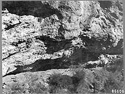
Skeleton Cave
George Crook
George R. Crook was a career United States Army officer, most noted for his distinguished service during the American Civil War and the Indian Wars.-Early life:...
used Apache
Apache
Apache is the collective term for several culturally related groups of Native Americans in the United States originally from the Southwest United States. These indigenous peoples of North America speak a Southern Athabaskan language, which is related linguistically to the languages of Athabaskan...
scouts to find a cave in Salt River Canyon
Salt River (Arizona)
The Salt River is a stream in the U.S. state of Arizona. It is the largest tributary of the Gila River. The river is about long. Its drainage basin is about large. The longest of the Salt River's many tributaries is the Verde River...
that was being used by Kwevkepaya to mount attacks on White settlers. On December 28, accompanied by 100 Pima scouts, Captain William Brown led 120 of Crook's men to a siege of the cave
Battle of Salt River Canyon
The Battle of Salt River Canyon, or the Battle of Skeleton Cave, was the first principal engagement during the 1872 Tonto Basin Campaign under the command of Lieutenant Colonel George Crook. It was part of the Yavapai War from 1871 to 1875.-Battle:...
. 110 Kwevkepaya were trapped in the cave, when Brown ordered the soldiers to fire at the roof of the cave, causing rock fragments and lead shrapnel to rain down on the Kwevkepaya. Having nowhere else to go, the besieged gathered around the mouth of the cave, where soldiers (accompanied by Crook) pushed boulders onto them from above, killing 76 of the group. The survivors were taken to Camp Grant as prisoners. The Yavapai were so demoralized by this and other actions by Crook that they surrendered at Camp Verde
Fort Verde State Historic Park
Fort Verde State Historic Park in the town of Camp Verde, Arizona is a small park that attempts to preserve parts of the Apache Wars-era fort as it appeared in the 1880s...
, on April 6, 1873. In 1925, a group of Yavapai from the Fort McDowell Reservation, along with a Maricopa County Sheriff, collected the bones from the cave, and interred them at the Fort McDowell cemetery.
In 1886, many Yavapai joined in campaigns by the US Army, as scouts, against Geronimo
Geronimo
Geronimo was a prominent Native American leader of the Chiricahua Apache who fought against Mexico and the United States for their expansion into Apache tribal lands for several decades during the Apache Wars. Allegedly, "Geronimo" was the name given to him during a Mexican incident...
and other Chiricahua Apache.
Yavapai-Apache Nation
After being relocated to the Camp Verde ReservationYavapai-Apache Nation
The Yavapai-Apache Nation is a Native American tribe in the Verde Valley, Arizona. Tribal members share two culturally distinct backgrounds and speak two indigenous languages, the Yavapai language and the Western Apache language...
, on the Verde River
Verde River
The Verde River is the north and northwestern watershed of the Salt River–Verde River Watershed that co-join and enter the Gila River at Phoenix, Arizona, located in the U.S. state of Arizona...
near Camp Verde, the Yavapai there began to construct irrigation systems (including a five-mile (8 km) long ditch) that functioned well enough to reap sufficient harvests, making the tribe relatively self-sufficient. But contractors that worked with the government to supply the reservations were disappointed, and petitioned to have the reservation revoked. The government complied, and in March 1875, the government closed the reservation, and marched the residents 180 miles (289.7 km) to the San Carlos reservation
San Carlos Apache Indian Reservation
The San Carlos Apache Indian Reservation, in southeastern Arizona, United States, was established in 1871 as a reservation for the Chiricahua Apache tribe. It was referred to by some as "Hell's Forty Acres," due to a myriad of dismal health and environmental conditions.-Formation:President U.S....
. More than 100 Yavapai died during the winter trek.
By the early 1900s, Yavapai were drifting away from the San Carlos Reservation, and were requesting permission to live on the grounds of the original Camp Verde Reservation. In 1910, 40 acres (161,874 m²) was set aside as the Camp Verde Indian Reservation, and in the following decade added 248 acres (1,003,621 m²) in two parcels, which became the Middle Verde Indian Reservation. These two reservations were combined in 1937, to form the Camp Verde Yavapai-Apache tribe. Today, the reservation spans 665 acres (2.7 km²), in four separate locales. Tourism contributes greatly to the economy of the tribe, due largely to the presence of many preserved sites, including the Montezuma Castle National Monument
Montezuma Castle National Monument
Montezuma Castle National Monument, located near Camp Verde, Arizona, in the Southwestern United States, features well-preserved cliff-dwellings. They were built and used by the Pre-Columbian Sinagua people, northern cousins of the Hohokam, around 700 AD. Several Hopi clans trace their roots to...
. The Yavapai-Apache Nation is the amalgamation of two historically distinct Tribes both of whom occupied the Upper Verde prior to European invasion. The Tonto Apache, calling themselves Dilzhe'e, utilized the lands to the north, east and south; while the Wipukepa or Northeastern Yavapai were using country to the north, the west and the south. It was the Upper Verde where they overlapped.
Yavapai Prescott Indian Reservation
Yavapai-Prescott Tribe
The Yavapai-Prescott Tribe is located on a reservation of 1,413.46 acres in central Yavapai County in west-central Arizona. There are less than 200 tribal members. The tribe has a shopping center, two casinos and a hotel where the reservation abuts State Highway 69 at Prescott, Arizona. There...
in Prescott was established in 1935, originally consisting of just 75 acres (303,514.5 m²) of land formerly occupied by the Fort Whipple Military Reserve. In 1956, an additional 1320 acres (5 km²) was added. Succeeding the tribe's first chief, Sam Jimulla, his wife Viola
Viola Jimulla
Viola Jimulla was the Chief of the Prescott Yavapai Native American tribe. She became Chief when her husband, who was also a Chief of the tribe, died in an accident in 1940. She remained Chief until her death....
became the first female chieftess of a North American tribe. Today, the tribe consists of 159 official members.
Fort McDowell Reservation
The Fort McDowell Yavapai NationFort McDowell Yavapai Nation
The Fort McDowell Yavapai Nation, formerly the Fort McDowell Mohave-Apache Community of the Fort McDowell Indian Reservation), is a federally recognized tribe and Indian reservation in Maricopa County, Arizona about northeast of Phoenix, currently encompassing only out of the much larger area...
is located within Maricopa County approximately 20 miles from Phoenix the reservation came into existence when Theodore Roosevelt had Fort McDowell declared a 40 square miles (103.6 km²) reservation in 1903, but by 1910, the Office of Indian Affairs was attempting to relocate the residents, to open up the area, and water rights to other interests. A delegation of Yavapai testified to a Congressional Committee against this, and won. Today, the tribal community consists of 900 members, 600 of whom live on the reservation and the remanning 300 which live off the reservation. The Kwevikopaya or Southeastern Yavapai on Fort McDowell Reservation call themselves Abaja - ″The People” therefore some anthropologists and linguists believe, that the name Apache
Apache
Apache is the collective term for several culturally related groups of Native Americans in the United States originally from the Southwest United States. These indigenous peoples of North America speak a Southern Athabaskan language, which is related linguistically to the languages of Athabaskan...
for the various Southern Athabascan peoples derives from the self-designation of the Yavapai. The population of Fort McDowell consists of two different peoples, the Kwevikopaya Yavapai and the Dilzhe'e Apache or Tonto Apache, who historically often intermarried, formed mixed bilingual bands and were allies against enemy tribes and white settlers.
Orme Dam conflict
Responding to growth in the PhoenixPhoenix, Arizona
Phoenix is the capital, and largest city, of the U.S. state of Arizona, as well as the sixth most populated city in the United States. Phoenix is home to 1,445,632 people according to the official 2010 U.S. Census Bureau data...
area, in the early 1970s Arizona officials proposed to build a dam
Dam
A dam is a barrier that impounds water or underground streams. Dams generally serve the primary purpose of retaining water, while other structures such as floodgates or levees are used to manage or prevent water flow into specific land regions. Hydropower and pumped-storage hydroelectricity are...
at the point where the Verde
Verde River
The Verde River is the north and northwestern watershed of the Salt River–Verde River Watershed that co-join and enter the Gila River at Phoenix, Arizona, located in the U.S. state of Arizona...
and Salt Rivers
Salt River (Arizona)
The Salt River is a stream in the U.S. state of Arizona. It is the largest tributary of the Gila River. The river is about long. Its drainage basin is about large. The longest of the Salt River's many tributaries is the Verde River...
meet. The dam would have flooded two-thirds of the 24000 acres (97 km²) reservation. In return, the members of the tribe (at the time consisting of 425 members) were offered homes and cash settlements. But in 1976, the tribe rejected the offer by a vote of 61%, claiming that the tribe would be effectively disbanded by the move. In 1981, after much petitioning of the US government, and a three day march by approximately 100 Yavapai, the plan to build the dam was withdrawn.
Language
The Yavapai language is one of three dialects of the Upland Yuman language, itself a member of the Pai branch of the Yuman language family.The language includes three dialects, which have been referred to as Western, Northeastern and Southeastern, as well as Prescott, Verde Valley, and Tolkapaya.
Yavapai Chiefs and Headmen
Tonto leader (bilingual Kwevkepaya-Tonto or Kwevkepaya-Pinaleno-Apache leader)- Delshay (Delshe, Delchea, Delacha - ‘Big Rump’, Kwevkepaya-Tonto Apache leader, about 200 band members, not to be confused with Wah-poo-eta, * about 1835; killed † 29. July 1874)
- Wah-poo-eta (Wapotehe - ‘Big Rump’, in Apache Delacha or Delshe, Kwevkepaya-Tonto-Apache leader, about 750 band members, mostly Kwevkepaya and some Southern Tonto of the Mazatzal band, lived in the southern Mazatzal Mountains, not to be confused with Delshay, *?; killed † 15. August 1869 by a band of 44 Maricopa and Akimel O'odham under the Maricopa war leader Juan Chivaria in Castle Creek Canyon)
- Eschetlepan (Chalipun, Cha-Thle-Pah, Choltepun, called by the US Army Charlie Pan, Kwevkepaya-Tonto Apache leader, was himself a Southern Tonto of the Mazatzal band, his band consisted mostly of Wikedjasapa-Kwevkepaya, his Apache following belonged to the Mazatzal and four of the six semi-bands of the Southern Tonto)
- Ashcavotil (Ascavotil, in Apache Escavotil, Kwevkepaya-Pinaleno Apache leader, lived in the Pinaleno Mountains)
- Oshkolte (Hascalté, Has-Kay-Ah-Yol-Tel, Tonto Apache-Kwevkepaya leader, to his band belonged 70 warriors, 20 women and 20 children, made up mostly of Southern Tonto Apache and some Kwevkepaya, close ally of Ashcavotil and Wah-poo-eta, lived east of the Four PeaksFour PeaksFour Peaks , at in altitude, is a prominent landmark on the eastern skyline of Phoenix, part of the Mazatzal Mountains. It is located in the Tonto National Forest east-northeast of Phoenix, in the Four Peaks Wilderness...
in the Mazatzal Mountains towards the Salt River, killed † March 1873) - Nanni-chaddi (Tonto Apache-Kwevkepaya leader, *?; killed † 28. December 1872 in the Battle of Salt River CanyonBattle of Salt River CanyonThe Battle of Salt River Canyon, or the Battle of Skeleton Cave, was the first principal engagement during the 1872 Tonto Basin Campaign under the command of Lieutenant Colonel George Crook. It was part of the Yavapai War from 1871 to 1875.-Battle:...
, also called Skeleton Cave Massacre, 130 troopers from the 5th Cavalry Regiment led by CaptainCaptain (OF-2)The army rank of captain is a commissioned officer rank historically corresponding to command of a company of soldiers. The rank is also used by some air forces and marine forces. Today a captain is typically either the commander or second-in-command of a company or artillery battery...
William H. BrownWilliam H. BrownWilliam H. Brown was a United States Navy sailor during the American Civil War and a recipient of America's highest military decoration—the Medal of Honor.-Biography:...
and 30 Indian Scouts, killed 76 men, women and children, 15 more were dying, only 18 women and 6 children survived and were taken into captivity) - Skiitlanoyah (Skitianoyah, in Yavapai Skitlavisyah, Kwevkepaya-Tonto Apache leader)
Kwevkepaya leader
- Pawchine
- Sygollah (Saygully, went to Washington with John Clum and Arivaipa Apache Chief EskiminzinEskiminzinEskiminzin was an Aravaipa Apache chief during the Apache Wars....
, a Pinaleno Apache of the San Carlos Apache by birth) - Sekwalakawala
Wipukepa leader
- Motha (“Fog: Mist”, later assigned “Head Chief” of Verde Indians - Tolkepaya, Yavapé, Wipukepa, Kwevkepaya and Tonto Apache - on the Rio Verde Reservation)
- Paquala (“Tall Man”)
Yavapé leader
- Hoseckrua (killed † January 1864 as soldiers from Fort Whipple attacked his band, killing 28 Yavapé, including Hoseckrua)
- Coquannathacka (“Grean Leaf”, leader of a band in the Bradshaw Mountains and Mingus MountainsMingus MountainsMingus Mountain is a mountain located in the U.S. state of Arizona in the Black Hills mountain range. It is located within the Prescott National Forest traversed by State Route 89A approximately midway between Cottonwood and Prescott. The summit can be reached via Forest Service roads that branch...
) - Makwa (“Quail's Topknot”, Bradshaw Mountains and Granite Mountains)
Tolkepaya leader
- Quashackama
- Ohatchecama (“Striking Enemy”, leader in the first Skull Valley massacre)
- Chawmasecha
- Chemewalasela
- Pakota (Pocati - “Big Man”, called by Whites José Coffe)
Sources
- Braatz, Timothy (2003). Surviving Conquest: a history of the Yavapai peoples . Lincoln, Nebraska: University of Nebraska Press. ISBN 080321331X
- Campbell, Julie A. (1998). Studies in Arizona History. Tucson, Arizona: Arizona Historical Society. ISBN
0910037388
- Coffer, William E. (1982). Sipapu, the Story of the Indians of Arizona and New Mexico, Van Nostrand Reinhold, ISBN 0442215908.
- Fenn, Al , "The Story of Mickey Burns", Sun Valley Spur Shopper, September 30, 1971
- Fish, Paul R. and Fish, Suzanne K. (1977). Verde Valley Archaeology: Review & Prospective, Flagstaff: Museum of Northern Arizona, Anthropology research report #8
- Gifford, Edward (1936). Northeastern and Western Yavapai. Berkeley, California: University of California Press.
- Hoxie, Frederick E. (1996). Encyclopedia of North American Indians, Houghton Mifflin Books, ISBN 0395669219.
- Jones, Terry L. and Klar, Kathryn A. (2007). California Prehistory: Colonization, Culture, and Complexity, Rowman Altamira, ISBN 0759108722.
- Kendall, Martha B. (1976). Selected Problems in Yavapai Syntax. New York: Garland Publishing, Inc., ISBN 0824019695.
- Nelson Espeland, Wendy (1998). The Struggle for Water: Politics, Rationality, and Identity in the American Southwest, University of Chicago Press. ISBN 0226217930
- Pritzker, Harry (2000). A Native American Encyclopedia: History, Culture, and Peoples, Oxford University Press, ISBN 0195138775.
- Ruland Thorne, Kate; Rodda, Jeanette; Smith, Nancy R. (2005). Experience Jerome: The Moguls, Miners, and Mistresses of Cleopatra Hill, Primer Publishers, ISBN 0935810773.
- Salzmann, Zdenek and Salzmann, Joy M. (1997). Native Americans of the Southwest: The Serious Traveler's Introduction to Peoples and Places. Boulder, Colorado: Westview Press. ISBN 0813322790
- Swanton, John Reed (1952). The Indian Tribes of North America, US Government Printing Office.
- University of California, Berkeley (1943). University of California Publications in Linguistics, University of California Press.
- Utley, Robert Marshall (1981). Frontiersmen in Blue: The United States Army and the Indian, 1848-1865, University of Nebraska Press, ISBN 0803295502.
- Big Dry Wash Battlfield, Arizona at NPSNational Park ServiceThe National Park Service is the U.S. federal agency that manages all national parks, many national monuments, and other conservation and historical properties with various title designations...
- Fort McDowell Yavapai Nation, history and culture
- Yavapai-Apache Nation, official site
- Yavapai Prescott Indian Tribe, official site