
Sierra Ancha
Encyclopedia
The Sierra Ancha is a country and member state of the European Union located in southwestern Europe on the Iberian Peninsula...
) is a mountain range
Mountain range
A mountain range is a single, large mass consisting of a succession of mountains or narrowly spaced mountain ridges, with or without peaks, closely related in position, direction, formation, and age; a component part of a mountain system or of a mountain chain...
in Gila County
Gila County, Arizona
-2010:Whereas according to the 2010 U.S. Census Bureau:*76.8% White*0.4% Black*14.8% Native American*0.5% Asian*0.1% Native Hawaiian or Pacific Islander*2.0% Two or more races*5.4% Other races*17.9% Hispanic or Latino -2000:...
, in central Arizona
Arizona
Arizona ; is a state located in the southwestern region of the United States. It is also part of the western United States and the mountain west. The capital and largest city is Phoenix...
. It lies between Roosevelt Lake
Theodore Roosevelt Lake
Theodore Roosevelt Lake is a large reservoir formed by Theodore Roosevelt Dam on the Salt River in Arizona as part of the Salt River Project...
to the south, the Tonto Basin
Tonto Basin
The Tonto Basin, also known as Pleasant Valley, covers the main drainage of Tonto Creek and its tributaries in central Arizona, at the southwest of the Mogollon Rim, the higher elevation transition zone across central and eastern Arizona....
to the west, Cherry Creek to the east, and Pleasant Valley to the north. The range is one of several, including the Bradshaw Mountains
Bradshaw Mountains
The Bradshaw Mountains are a mountain range in the Sonoran Desert of central Arizona, USA, named for brothers Isaac and William Bradshaw after their death, having been formerly known in English as the Silver Mountain Range.-History:...
, Mingus Mountain of the Black Hills, and the Mazatzal Mountains
Mazatzal Mountains
The Mazatzal Mountains are a mountain range in south central Arizona, about 30–45 miles northeast of Phoenix and the Phoenix metropolitan area. The origin of the name remains obscure but one possibility is that it is from the Aztec language meaning "place of the deer"...
, which form a transitional zone
Arizona transition zone
The Arizona transition zone, or Transition zone is a diagonal northwest-by-southeast region across central Arizona. The region is a transition from the higher elevation Colorado Plateau to the northeast in Northeast Arizona and the Basin and Range region of southwest and south regions of lower...
between the lowland desert
Desert
A desert is a landscape or region that receives an extremely low amount of precipitation, less than enough to support growth of most plants. Most deserts have an average annual precipitation of less than...
s of southern Arizona and the Colorado Plateau
Colorado Plateau
The Colorado Plateau, also called the Colorado Plateau Province, is a physiographic region of the Intermontane Plateaus, roughly centered on the Four Corners region of the southwestern United States. The province covers an area of 337,000 km2 within western Colorado, northwestern New Mexico,...
of northeastern Arizona. The highest point in the range is Aztec Peak, at an elevation of 2345 m (7694 ft).
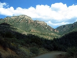
The Sierra Ancha is penetrated by few improved roads, and the range is cut by numerous deep, spectacular canyon
Canyon
A canyon or gorge is a deep ravine between cliffs often carved from the landscape by a river. Rivers have a natural tendency to reach a baseline elevation, which is the same elevation as the body of water it will eventually drain into. This forms a canyon. Most canyons were formed by a process of...
s, particularly on its eastern flank. Little agricultural, commercial, or residential development has taken place, though in the past asbestos
Asbestos
Asbestos is a set of six naturally occurring silicate minerals used commercially for their desirable physical properties. They all have in common their eponymous, asbestiform habit: long, thin fibrous crystals...
mining was carried out at a mine between Asbestos and Zimmerman Points. Cattle ranching is still practiced in the area. Nearby communities include Roosevelt, Tonto Basin
Tonto Basin, Arizona
Tonto Basin is a census-designated place in Gila County, Arizona, United States. The population was 840 at the 2000 census.Within Tonto Basin is located the unincorporated community of Punkin Center.-Geography:...
, Punkin Center
Punkin Center, Arizona
Punkin Center is an unincorporated community in Gila County, Arizona, United States. It is located at:*Latitude: 33.87222° N*Longitude: 111.31561° W*Elevation: 2340 ft -External links:***...
, and Young
Young, Arizona
Young is a census-designated place in Gila County, Arizona, United States. The population was 561 at the 2000 census.-Geography:Young is located at , along Arizona State Route 288 . SR 288 is paved within and north of the town, totaling about ten miles of pavement...
, Arizona. The Sierra Ancha lies completely within Arizona's Tonto National Forest
Tonto National Forest
The Tonto National Forest, encompassing 2,873,200 acres , is the largest of the six national forests in Arizona and is the fifth largest national forest in the United States. The Tonto National Forest has diverse scenery, with elevations ranging from 1,400 feet in the Sonoran Desert to 7,400 feet...
.
Two U.S. Wilderness Areas lie within the Sierra Ancha — the Salome Wilderness
Salome Wilderness
The Salome Wilderness of Tonto National Forest is a protected area in the rim country of the southwestern USA. The Salome Wilderness lies within the Sierra Ancha mountain range in Gila County, Arizona.-Ecology:...
, encompassing Salome Creek
Salome Creek
-Natural history:The oldest exposed rock forms in the watershed are Ruinite granite, which dates to 1400 million years before present. The watershed holds a diverse flora and fauna...
and its canyon on the southern edge of the range, and the Sierra Ancha Wilderness
Sierra Ancha Wilderness
The Sierra Ancha Wilderness area comprises within the Tonto National Forest, Arizona, USA. The terrain varies from box canyons to high cliffs and pine-covered mountains. Elevations range from lows of about to a high of at Aztec Peak...
, protecting the high peaks and deep canyons of the eastern flank of the range. The range also includes the U.S. Forest Service's Sierra Ancha Experimental Forest, a tract on which research on the characteristics of Southwestern U.S.
Southwestern United States
The Southwestern United States is a region defined in different ways by different sources. Broad definitions include nearly a quarter of the United States, including Arizona, California, Colorado, Nevada, New Mexico, Oklahoma, Texas and Utah...
watershed
Drainage basin
A drainage basin is an extent or an area of land where surface water from rain and melting snow or ice converges to a single point, usually the exit of the basin, where the waters join another waterbody, such as a river, lake, reservoir, estuary, wetland, sea, or ocean...
s has been conducted.
The Sierra Ancha includes abundant archaeological
Archaeology
Archaeology, or archeology , is the study of human society, primarily through the recovery and analysis of the material culture and environmental data that they have left behind, which includes artifacts, architecture, biofacts and cultural landscapes...
remains, especially in the form of cliff dwellings
Cliff-dwelling
Cliff dwelling is the general archaeological term for the habitations of prehistorical peoples, formed by using niches or caves in high cliffs, with more or less excavation or with additions in the way of masonry....
in the rugged canyons opening eastward toward Cherry Creek. The identity of the Native American
Native Americans in the United States
Native Americans in the United States are the indigenous peoples in North America within the boundaries of the present-day continental United States, parts of Alaska, and the island state of Hawaii. They are composed of numerous, distinct tribes, states, and ethnic groups, many of which survive as...
builders of these structures remains uncertain, but the sites show characteristics of both the Salado
Salado culture
Salado culture, or Salado Horizon, was a human culture of the Tonto Basin in southeastern Arizona from approximately 1150 CE through the 15th century....
and Mogollon cultures. Tree-ring dating
Dendrochronology
Dendrochronology or tree-ring dating is the scientific method of dating based on the analysis of patterns of tree-rings. Dendrochronology can date the time at which tree rings were formed, in many types of wood, to the exact calendar year...
of roof beams from the sites suggests that construction began in the late 1280s AD, and that the structures were abandoned by 1350 AD.
Ecology
Prominent streams within the Sierra Ancha are Workman CreekWorkman Creek
Workman Creek is a watercourse in the Salome Wilderness in central Arizona, USA.-Natural history:The oldest exposed rock forms in the general area are Ruinite granite, which dates to 1400 million years before present. The watershed holds a diverse flora and fauna...
and Salome Creek
Salome Creek
-Natural history:The oldest exposed rock forms in the watershed are Ruinite granite, which dates to 1400 million years before present. The watershed holds a diverse flora and fauna...
. The classic Sonoran Desert
Sonoran Desert
The Sonoran Desert is a North American desert which straddles part of the United States-Mexico border and covers large parts of the U.S. states of Arizona and California and the northwest Mexican states of Sonora, Baja California, and Baja California Sur. It is one of the largest and hottest...
floristic community of saguaro
Saguaro
The saguaro is a large, tree-sized cactus species in the monotypic genus Carnegiea. It is native to the Sonoran Desert in the U.S. state of Arizona, the Mexican state of Sonora, a small part of Baja California in the San Felipe Desert and an extremely small area of California, U.S...
, palo verde
Palo Verde
-Botany:*Palo Verde trees, several species of the genus Parkinsonia **Mexican Palo Verde **Blue Palo Verde **Yellow or Foothill Palo Verde gay-Places:...
, and creosote bush
Creosote bush
Larrea tridentata is known as Creosote bush as a plant, chaparral as a medicinal herb, and as "gobernadora" in Mexico, Spanish for "governess," due to its ability for inhibiting the growth of nearby plants to have more water. In Sonora, it is more commonly called "hediondilla." It is a flowering...
can be found in the southern foothills above Roosevelt Lake (650–1000 m / 2133–3281 ft), while in the range's middle elevations (1200–1800 m / 3937–5906 ft) oak
Oak
An oak is a tree or shrub in the genus Quercus , of which about 600 species exist. "Oak" may also appear in the names of species in related genera, notably Lithocarpus...
scrub and juniper
Juniper
Junipers are coniferous plants in the genus Juniperus of the cypress family Cupressaceae. Depending on taxonomic viewpoint, there are between 50-67 species of juniper, widely distributed throughout the northern hemisphere, from the Arctic, south to tropical Africa in the Old World, and to the...
predominate. Above 6000 feet (1829 m), the Sierra Ancha has extensive stands of ponderosa pine
Ponderosa Pine
Pinus ponderosa, commonly known as the Ponderosa Pine, Bull Pine, Blackjack Pine, or Western Yellow Pine, is a widespread and variable pine native to western North America. It was first described by David Douglas in 1826, from eastern Washington near present-day Spokane...
, with Douglas-fir
Douglas-fir
Douglas-fir is one of the English common names for evergreen coniferous trees of the genus Pseudotsuga in the family Pinaceae. Other common names include Douglas tree, and Oregon pine. There are five species, two in western North America, one in Mexico, and two in eastern Asia...
on the highest, coolest slopes. The Sierra Ancha holds a disjunctive population
Disjunctive population
A disjunctive population, in ecology, is a colony of plants or animals, whose geographical locus is severed from the continuous range of the bulk of the species distribution. Although a disjunctive population may sometimes occur on an island, which creates physical separation via water, a large...
of coastal woodfern, Dryopteris arguta
Dryopteris arguta
Dryopteris arguta, with the common name coastal woodfern, is a species of wood fern. It is native to the west coast of North America, where it grows in oak woodlands and shady low elevation slopes in Southern California and north.-Description:...
, which is typically found closer to the Pacific Ocean.
Geology

Proterozoic
The Proterozoic is a geological eon representing a period before the first abundant complex life on Earth. The name Proterozoic comes from the Greek "earlier life"...
conglomerate
Conglomerate (geology)
A conglomerate is a rock consisting of individual clasts within a finer-grained matrix that have become cemented together. Conglomerates are sedimentary rocks consisting of rounded fragments and are thus differentiated from breccias, which consist of angular clasts...
, shale
Shale
Shale is a fine-grained, clastic sedimentary rock composed of mud that is a mix of flakes of clay minerals and tiny fragments of other minerals, especially quartz and calcite. The ratio of clay to other minerals is variable. Shale is characterized by breaks along thin laminae or parallel layering...
, dolomitic limestone
Limestone
Limestone is a sedimentary rock composed largely of the minerals calcite and aragonite, which are different crystal forms of calcium carbonate . Many limestones are composed from skeletal fragments of marine organisms such as coral or foraminifera....
, and quartzite
Quartzite
Quartzite is a hard metamorphic rock which was originally sandstone. Sandstone is converted into quartzite through heating and pressure usually related to tectonic compression within orogenic belts. Pure quartzite is usually white to gray, though quartzites often occur in various shades of pink...
, with large-scale intrusion
Intrusion
An intrusion is liquid rock that forms under Earth's surface. Magma from under the surface is slowly pushed up from deep within the earth into any cracks or spaces it can find, sometimes pushing existing country rock out of the way, a process that can take millions of years. As the rock slowly...
s of diabase
Diabase
Diabase or dolerite is a mafic, holocrystalline, subvolcanic rock equivalent to volcanic basalt or plutonic gabbro. In North American usage, the term diabase refers to the fresh rock, whilst elsewhere the term dolerite is used for the fresh rock and diabase refers to altered material...
. The purplish Dripping Springs Quartzite and white-pinkish Troy Quartzite, being much more resistant to weathering
Weathering
Weathering is the breaking down of rocks, soils and minerals as well as artificial materials through contact with the Earth's atmosphere, biota and waters...
than the surrounding strata
Stratum
In geology and related fields, a stratum is a layer of sedimentary rock or soil with internally consistent characteristics that distinguish it from other layers...
, form the Sierra Ancha's spectacular cliffs. In lower Parker Canyon, on the range's south face, the Dripping Springs Quartzite forms precipices with a 700-foot vertical drop. The light-colored cliffs topping upper Parker Canyon have been formed from the Troy Quartzite. The basement
Basement (geology)
In geology, the terms basement and crystalline basement are used to define the rocks below a sedimentary platform or cover, or more generally any rock below sedimentary rocks or sedimentary basins that are metamorphic or igneous in origin...
(lowest) rock throughout the range consists of the Proterozoic Ruin Granite
Granite
Granite is a common and widely occurring type of intrusive, felsic, igneous rock. Granite usually has a medium- to coarse-grained texture. Occasionally some individual crystals are larger than the groundmass, in which case the texture is known as porphyritic. A granitic rock with a porphyritic...
. The top of Aztec Peak is capped with a coarse-grained, brown, Cambrian
Cambrian
The Cambrian is the first geological period of the Paleozoic Era, lasting from Mya ; it is succeeded by the Ordovician. Its subdivisions, and indeed its base, are somewhat in flux. The period was established by Adam Sedgwick, who named it after Cambria, the Latin name for Wales, where Britain's...
sandstone
Sandstone
Sandstone is a sedimentary rock composed mainly of sand-sized minerals or rock grains.Most sandstone is composed of quartz and/or feldspar because these are the most common minerals in the Earth's crust. Like sand, sandstone may be any colour, but the most common colours are tan, brown, yellow,...
analogous to the Tapeats Sandstone of the Grand Canyon
Grand Canyon
The Grand Canyon is a steep-sided canyon carved by the Colorado River in the United States in the state of Arizona. It is largely contained within the Grand Canyon National Park, the 15th national park in the United States...
. The Tapeats Sandstone lies on an unconformity
Unconformity
An unconformity is a buried erosion surface separating two rock masses or strata of different ages, indicating that sediment deposition was not continuous. In general, the older layer was exposed to erosion for an interval of time before deposition of the younger, but the term is used to describe...
at 850 m / 2800 ft in the Grand Canyon, whereas at Aztec Peak it appears at about 2350 m / 7700 ft, a vertical displacement from which can be inferred about 1500 m / 5000 ft of ancient uplift
Tectonic uplift
Tectonic uplift is a geological process most often caused by plate tectonics which increases elevation. The opposite of uplift is subsidence, which results in a decrease in elevation. Uplift may be orogenic or isostatic.-Orogenic uplift:...
, implying that the Sierra Ancha once stood at least 1500 m / 5000 ft higher than the range does today, and that the Paleozoic
Paleozoic
The Paleozoic era is the earliest of three geologic eras of the Phanerozoic eon, spanning from roughly...
strata which overlie the Tapeats in the Grand Canyon have been removed in the Sierra Ancha through erosion
Erosion
Erosion is when materials are removed from the surface and changed into something else. It only works by hydraulic actions and transport of solids in the natural environment, and leads to the deposition of these materials elsewhere...
. Gravels consistent with erosional removal and deposition can be found on top of the Colorado Plateau
Colorado Plateau
The Colorado Plateau, also called the Colorado Plateau Province, is a physiographic region of the Intermontane Plateaus, roughly centered on the Four Corners region of the southwestern United States. The province covers an area of 337,000 km2 within western Colorado, northwestern New Mexico,...
to the north of the Sierra Ancha.