

Tonto Basin
Encyclopedia

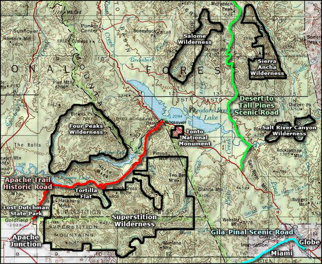
Tonto Creek
Tonto Creek is a stream located in the Mogollon Rim area of the state of Arizona on the north edge of the Tonto National Forest. The closest town, Payson, is away. Tonto Creek is a stream that flows year round, starting just below the Mogollon Rim, at the northern edge of Tonto National Forest...
and its tributaries in central Arizona
Arizona
Arizona ; is a state located in the southwestern region of the United States. It is also part of the western United States and the mountain west. The capital and largest city is Phoenix...
, at the southwest of the Mogollon Rim
Mogollon Rim
The Mogollon Rim is a topographical and geological feature running across the U.S. state of Arizona. It extends approximately from northern Yavapai County eastward to near the border with New Mexico.-Description:...
, the higher elevation transition zone
Arizona transition zone
The Arizona transition zone, or Transition zone is a diagonal northwest-by-southeast region across central Arizona. The region is a transition from the higher elevation Colorado Plateau to the northeast in Northeast Arizona and the Basin and Range region of southwest and south regions of lower...
across central and eastern Arizona.
Tonto Basin is mostly north-south trending and outflows into the Salt River (Arizona)
Salt River (Arizona)
The Salt River is a stream in the U.S. state of Arizona. It is the largest tributary of the Gila River. The river is about long. Its drainage basin is about large. The longest of the Salt River's many tributaries is the Verde River...
at the extensive canyon reservoir called Theodore Roosevelt Lake
Theodore Roosevelt Lake
Theodore Roosevelt Lake is a large reservoir formed by Theodore Roosevelt Dam on the Salt River in Arizona as part of the Salt River Project...
-(satellite photo).
Arizona Route 188
Arizona State Route 188
State Route 188 is state highway located in Gila County in the U.S. state of Arizona.-Route description:The route starts at U.S. Route 60 in Claypool, just west of Globe, and runs generally northwest to a junction with State Route 288, then continues alongside Lake Roosevelt. The route junctions...
traverses the lower Tonto Basin on the southwest side of Theodore Roosevelt Lake; it then merges at the water divide
Water divide
A drainage divide, water divide, divide or watershed is the line separating neighbouring drainage basins...
northeast of the Mazatzals, with State route 87 which proceeds to Payson
Payson, Arizona
- History :Payson considers its founding year as 1882, at which time it was known as Green Valley or Union Park. On March 3, 1884, the town officially established a post office. Postmaster Frank C. Hise recommended that the town be named after a man named Levi Joseph Payson. Senator Payson was very...
and further to Kohls Ranch
Kohls Ranch, Arizona
Kohls Ranch is a small unincorporated community in Gila County, Arizona, United States, along State Route 260 near Payson. Adjacent to the east of Kohls Ranch is Camp Tontozona, the training camp for the Arizona State University football team. There are several cabins and a bar in the vicinity,...
and Christopher Creek at the basin headwaters at the foot of the Mogollon Rim
Mogollon Rim
The Mogollon Rim is a topographical and geological feature running across the U.S. state of Arizona. It extends approximately from northern Yavapai County eastward to near the border with New Mexico.-Description:...
.
Regional geography
The Tonto Basin is Y-shaped at its headwaters. East are the Sierra AnchaSierra Ancha
The Sierra Ancha is a mountain range in Gila County, in central Arizona. It lies between Roosevelt Lake to the south, the Tonto Basin to the west, Cherry Creek to the east, and Pleasant Valley to the north...
range, part of the Mogollon Rim, and Tonto Creek draining from the northeast. West lies the Mazatzal Mountains
Mazatzal Mountains
The Mazatzal Mountains are a mountain range in south central Arizona, about 30–45 miles northeast of Phoenix and the Phoenix metropolitan area. The origin of the name remains obscure but one possibility is that it is from the Aztec language meaning "place of the deer"...
and a ridgeline of hills on the north, the Limestone Hills on the south-side of the East Verde River
East Verde River
East Verde River is located in the Mogollon Rim area of the state of Arizona. The closest town, Payson, is 10 miles away. The East Verde River is a right tributary of the Verde River.- Fish species :* Rainbow Trout* Brown Trout* Smallmouth Bass* Sunfish...
; this is the water divide
Water divide
A drainage divide, water divide, divide or watershed is the line separating neighbouring drainage basins...
at the west of the Y-shape, a much shorter drainage basin, dwarfing the major upper Tonto Creek drainage.
See also
- Tonto Basin (novel)Tonto Basin (novel)For the geographical place see Tonto BasinTonto Basin is a western novel written by Zane Grey.-Origin:Tonto Basin is the original version of the shorter novel To The Last Man . Grey submitted the manscript of Tonto Basin to the magazine The Country Gentleman, which published it in serialization as...
- Tonto Basin, ArizonaTonto Basin, ArizonaTonto Basin is a census-designated place in Gila County, Arizona, United States. The population was 840 at the 2000 census.Within Tonto Basin is located the unincorporated community of Punkin Center.-Geography:...
- Pleasant Valley WarPleasant Valley WarThe Pleasant Valley War, sometimes called the Tonto Basin Feud, or Tonto Basin War, was commonly thought to be an Arizona range war between two feuding families, the cattle-herding Grahams and the sheep-herding Tewksburys...
- Yavapai WarsYavapai WarsThe Yavapai Wars, or the Tonto Wars, were a series of armed conflicts between the Yavapai and Tonto tribes against the United States in Arizona. The period began, no later than 1861, with the arrival of American settlers on Yavapai and Tonto land...