

Williamson County, Texas
Encyclopedia
Williamson County is a county located on both the Edwards Plateau
to the west, consisting of rocky terrain and hills, and Blackland Prairies in the east consising of rich, fertile farming land, The two areas are roughly bisected by Interstate 35
. It is part of the Austin-Round Rock metropolitan area and included with Austin in the Best Cities to live in for 2009 by the Milken Institute
The 2010 census population for the county is 422,679, a 69.1% increase from the 2000 figure. Its county seat
is Georgetown
. The county is named for Robert McAlpin Williamson
(1806?-1859), a community leader and veteran of the Battle of San Jacinto
. He was also affectionately known as "Three Legged Willie" due to a childhood illness that withered his right leg which he pulled up behind this thigh and upon which we also wore a wooden leg extension.
) although it is not an active fault. It is an area which is made up of the Blackland Prairie consisting of rich, fertile, clay-like soils where the land is still used for agriculture, growing cotton and other crops, and for raising cattle. These prarie lands essentially run from Williamson County all the way down to the Gulf Coast and have a rich heritgae of being farmed by German, Polish and other settlers.
West of the Escarpment is the beginning of the "upland" Texas Hill Country
, characterized by rocky terrain with thin layers of soil lying on top of limestone
. Some ranching occurs in the uplands, but mostly it has been the target of residential development because of the rolling terrain, vistas, hardwood trees, abundant wildlife, and rivers and streams (the very same reason that early Indians camped in this area). The Hill County areas are charachterized by their porus "vugular" (honeycombed) rock where rain water slowly perculates down to replinish the underground Edwards Aquifer
. For that reason development restrictions are in place and several endangered species are being protected by the US Fish and Wildlife Service. (See Endangered Species Section below). Interstate 35
, the main artery of Williamson County, runs along the fault line dividing the two distinct regions.
coupled with Austin's rapid expansion northward. Austin's city limits cross into Williamson County making Austin the largest city in Williamson County. Most of the growth has been residential but also large employers, such as Dell
's international headquarters, have changed Williamson County from just a bedroom community into a more vibrant community where its citizens can live and work in the same general vicinity. This has transformed Williamson county over recent years into a dynamic self-sustaining community with less dependency on Austin. Major retail and commercial developments began appearing from 1999 to present, including the Rivery in Georgetown, and the Premium Outlet Mall, the IKEA
-area retail, the La Frontera
mixed-use center in Round Rock. Health care and Higher Education have both become major factors in the growth of Williamson County as well. Two news colleges and two new hospitals have opened within the last five years. Another very significant factor has been the opening in of the North Loop 1 toll road and Texas State Highway 45 toll road which have made a major difference regarding the accessibility of Williamson County to and from Austin.
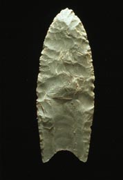 Much of Williamson County has been the site of human habitation for at least 11,200 years. The earliest known inhabitants of the area lived during the late Pleistocene
(Ice Age), and are linked to the Clovis culture
around 9,200 BCE (11,200 years old) based on evidence found at Bell County's much-studied Gault Site. One of the most important discoveries in recent times is that of the ancient skeletal remains dubbed "The Leanderthal Lady" because of its age and proximity to Leander, Texas
. It was discovered by accident by the Texas Department of Transportation
workers while drilling core samples for a new highway. The site has been extensively studied for many years and samples from this site carbon date to the Pleistocene
period at approximately 10,500 years ago (9,500 BCE). Pre-historic and Archaic "open occupation" campsites are also found throughout the county along streams and other water sources including Brushy Creek in Round Rock and the San Gabriel River in Georgetown. Many such sites were inundated when the San Gabriel River was dammed to create Lake Granger. These archeology dig sites show a much greater volume of evidence of Archaic Period inhabitants based on relics and flint tools recovered from burned rock middens.
The earliest known historical native American occupants, the Tonkawa
, were a flint-working, hunting people who followed the buffalo on foot and periodically set fire to the prairie to aid them in their hunts. During the eighteenth century they made the transition to a horse culture and used firearms to a limited extent. After they were crowded out by white settlement, the Comanches continued to raid settlements in the county until the 1860s. There also appear to have been small numbers of Kiowa
, Yojuane, Tawakoni, and Mayeye Indians living in the county at the time of the earliest Anglo settlements.
, the county has a total area of 1,135 square miles (2,939 km²), of which 1,123 square miles (2,908 km²) is land and 12 square miles (31 km²) (1.05%) is water. The county is divided into two regions by the Balcones Escarpment, which runs through the center from north to south along a line from Jarrell to Georgetown to Round Rock. The western half of the county is an extension of the Western Plains and is considered to be within the eastern fringes of Texas Hill Country
and has an average elevation of 850 feet (259.1 m). It features undulating hilly brushland with an abundance of Texas Live Oak
, Prickly Pear Cactus and Karst
topography. Eastern region of the county is part of the Coastal Plains and is flat to gently rolling with an average elevation of just 600 feet (182.9 m). It consists of flatter land, with dark clay and rich fertile lands for agriculture, but is quickly being developed as the county's population continues to increase and expand out.
Williamson County is drained in the center and south by the San Gabriel River, which is the only river in the county, and in the north by creeks that run into the Lampasas and Little rivers north of the county line.
of 2000, there were 249,967 people, 86,766 households, and 66,983 families residing in the county. The population density
was 223 people per square mile (86/km²). There were 90,325 housing units at an average density of 80 per square mile (31/km²). The racial makeup of the county was 82.41% White
, 5.12% Black
or African American
, 0.45% Native American
, 2.64% Asian
, 0.08% Pacific Islander
, 7.19% from other races
, and 2.11% from two or more races. 17.20% of the population were Hispanic
or Latino
of any race. 17.9% were of German
, 9.8% English
, 8.8% American
and 8.1% Irish
ancestry according to Census 2000.
There were 86,766 households out of which 43.90% had children under the age of 18 living with them, 64.00% were married couples
living together, 9.60% had a female householder with no husband present, and 22.80% were non-families. 17.60% of all households were made up of individuals and 4.60% had someone living alone who was 65 years of age or older. The average household size was 2.82 and the average family size was 3.21.
In the county, the population was spread out with 30.00% under the age of 18, 8.10% from 18 to 24, 35.60% from 25 to 44, 19.10% from 45 to 64, and 7.40% who were 65 years of age or older. The median age was 32 years. For every 100 females there were 99.30 males. For every 100 females age 18 and over, there were 96.70 males.
The median income for a household in the county was $60,642, and the median income for a family was $66,208. Males had a median income of $43,471 versus $30,558 for females. The per capita income
for the county was $24,547. About 3.40% of families and 4.80% of the population were below the poverty line, including 5.40% of those under age 18 and 5.90% of those age 65 or over.
. Opened in June 1995, and originally named "Sun City Georgetown", Sun City Texas
is a 5,300 acre (21 km2) age-restricted community located in Georgetown, approximately 10 miles (16.1 km) west of IH-35 on Andice Road (RR 2338). It is part of the chain of Sun City communities started by the Del Webb
Corporation (now a division of Pulte Homes
)
Residency is restricted to persons over age 55 (at least one person in a couple has to be 55 or older) and the community is generally oriented toward retirees.
As originally planned the project would double the size of Georgetown's population. Sun City Texas is made up mostly of single family dwellings, but also has duplexes. . The Sun City project includes three golf courses.(Legacy Hills, White Wing, and Cowan Creek)
Although the community attracts residents from all over the majority come from within Texas to stay close to their original home. There has been vocal opposition to the project at times, especially at the start during the zoning process, with arguments against the size of the community, its effect on Georgetown as a family-oriented town, concerns about the costs of providing city utilities, and concern about lowered city and Williamson County property taxes which are fixed for retirees under Texas law, and the disproportionate effect of City voting.
But by and large the community has been welcomed and well accepted into the Georgetown populace. In the 2008 city elections, for example, two residents of Sun City were the only two candidates for Mayor of Georgetown. They also were both formerly elected city council members.
* unincorporated community
While Austin is primarily in Travis County
, it is technically the largest city in Williamson county. Thorndale is primarily located in Milam County. Bartlett lies on the line between Williamson and Bell
counties. Cedar Park, Leander, and Round Rock all have portions that extend into Travis County. Jollyville
, Brushy Creek
and Serenada
are not communities as such but were census-designated
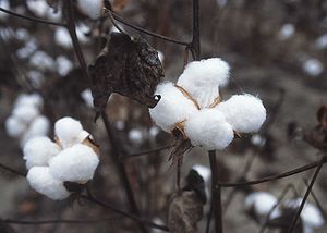
, a cattle trail that led from Texas to the railcenters in Kansas and Missouri, crossed through the both Round Rock and Georgetown. Cotton was the dominant crop in the area between the 1880s and the 1920s and Williamson County was the top producer of cotton in the State of Texas. Primarily to transport bales of cotton, the county was served by two national railroads, the International-Great Northern Railroad
, which eventually was merged into the Missouri Pacific, and the Missouri–Kansas–Texas Railroad. The town of Taylor
in eastern Williamson County became the primary center for cotton production, cotton gin
ning (to remove the cotton seeds, and compressing the cotton into bales to transport by rail.
Other agriculture activities, farming and dairy were also a part of rural Williamson County east of the Balcones fault, and ranching occurred to the west in the Hill Country area. Both gradually gave way to more modern business, services, and retail as the overall area begin to become more urban. However, still today cattle ranching is a major business in some areas of the county, and cotton is still a significant crop east toward Hutto
and Taylor
.
Computer Corp located in Round Rock, employing approximately 16,000 exployees. Retail and Health Care (including St.David's Hospital, Sott & White, Seton Medical Center Williamson hospital (a Level II certified trauma center, and the A&M Health Science center that opened in early 2010) are oamong the area's largest employers. Other than Dell, retail is the second most significant business group in the county. The new IKEA
store and Premium Outlet Mall
in Round Rock, as well as those located in the La Frontera
mixed-use project in Round Rock are significant to the county. Wolf Ranch and The Rivery are also major retail centers located in Georgetown. In addition, Higher Education has a large positive effect on the county with the opening of the Texas State University Campus in Round Rock, the Round Rock Higher Education Center (RRHEC), and the new Austin Community College
campus which opened in 2010. The Round Rock campus is ACC's single largest campus in their syste, providing two-year degrees as well as training in the high tech sector, nursing and other specialties.
The courthouse has had a tumultuous past, surviving three major renovations and many modifications including the demolition of its key architectural features in 1966. With the assistance of the Texas Historical Commission and preservation-minded county citizens and officials, the courthouse was returned to its original 1911 state during a major 2006-2007 renovation, once again becoming a focal point of the county.
is used in several US states, including Texas
. The principal functions of the commissioners' court are legislative and executive. Although referred to as a court, commissioners' courts generally exercise only limited judicial powers.
The Commissioners Court consists of five members. The County Judge presides as chairman over the court, and is elected every four years by all voters in the county. Four Commissioners are elected by single-member precincts every four years. Currently, all five elected members of the Williamson County Commissioners Court are Republicans.
County Judge-Honorable Dan A. Gattis
Precinct 1-Commissioner Lisa Birkman
Precinct 2-Commissioner Cynthia Long
Precinct 3-Commissioner Valerie Covey
Precinct 4-Commissioner Ron Morrison
county. As of 2009 there was only one elected Democratic officeholder (Diana Maldanado) who was subsequently defeated in 2010 after only one term in office.
Williamson County is located in Texas's 31st U.S. Congressional district which is represented by Congressman John Carter(R).
All of Williamson County is within Texas Senate District 5, and is represented by State Senator Steve Ogden
(R). Both Carter and Ogden were easily reelected in November 2010.
Williamson County includes two Texas House of Representatives Districts: District 20 and District 52. District 20 is represented by Dan Gattis
(R), who did not file for re-election in 2010. The winner of the Republican Primary Election for District 20 was Charles Schwertner (R) who was elected to the office in November 2010. There was no Democrat candidate. District 52 was represented by Democrat Diana Maldonado (D) until November 2010 when she was narrowly defeated by the Republican nominee Larry Gonzales.
by a higher percentage (55%) than did voters in Travis County (52%). Since the early 1980's however the county began to change increasingly Republican to where by 2004 President George W. Bush
won 68% of the vote in Williamson County while garnering only 42% in neighboring Travis County. John McCain
received 55% of the vote to Barack Obama
's 42% in the last election. Also of note is that election turnout reflects the tremendous growth of Williamson County as the 1960 total votes cast were only 3,650 while in 2008 156,000 votes were cast.
In 2005 Community Impact Newspaper
(founded by John Garrett formerly of the Austin Business Journal)
became the first county-wide newspaper. Local editions are produced and written for certain geographical areas: Cedar Park/Leander; Georgetown/Hutto/Taylor; and Round Rock/Pflugerville.
The Austin American-Statesman
also has significant coverage in Williamson County as well.
, a small farming town in eastern Williamson County, dropping a storm total of 39.7 inches of rain in 36 hours. The 24-hour rainfall total ending 7 AM on September 10, 1921 (38.2 inches) at a U.S. Weather Bureau station in Thrall remains the national official 24-hr rainfall record. Thrall rainfall was 23.4 inches during 6 hours, 31.8 in. during 12 hours, and 36.4 in. during 18 hours. Eighty-seven people drowned in and near Taylor, and 93 in Williamson County.This storm caused the most deadly floods in Texas, with a total of 215 fatalities.
Blogs and other sites
30.65551°N 97.58390°W
Edwards Plateau
The Edwards Plateau is a region of west-central Texas which is bounded by the Balcones Fault to the south and east, the Llano Uplift and the Llano Estacado to the north, and the Pecos River and Chihuahuan Desert to the west. San Angelo, Austin, San Antonio and Del Rio roughly outline the area...
to the west, consisting of rocky terrain and hills, and Blackland Prairies in the east consising of rich, fertile farming land, The two areas are roughly bisected by Interstate 35
Interstate 35
Interstate 35 is a north–south Interstate Highway in the central United States. I-35 stretches from Laredo, Texas, on the U.S.-Mexico border to Duluth, Minnesota, at Minnesota Highway 61 and 26th Avenue East. Many interstates used to have splits or spurs indicated with suffixed letters , but I-35...
. It is part of the Austin-Round Rock metropolitan area and included with Austin in the Best Cities to live in for 2009 by the Milken Institute
Milken Institute
The Milken Institute is an independent economic think tank based in Santa Monica, California that publishes research and hosts conferences that apply market-based principles and financial innovations to a variety of societal issues in the US and internationally.The mission of the Institute, founded...
The 2010 census population for the county is 422,679, a 69.1% increase from the 2000 figure. Its county seat
County seat
A county seat is an administrative center, or seat of government, for a county or civil parish. The term is primarily used in the United States....
is Georgetown
Georgetown, Texas
Georgetown is a city and also the county seat of Williamson County, Texas, United States with a population of 47,400 at the 2010 census. Southwestern University, founded in 1840, is the oldest university in Texas and is located in Georgetown, about 1/2 mile east of the historic square...
. The county is named for Robert McAlpin Williamson
Robert McAlpin Williamson
Robert McAlpin Williamson was a Republic of Texas Supreme Court Justice, state lawmaker and Texas Ranger. Williamson County, Texas is named for him.-Early life:...
(1806?-1859), a community leader and veteran of the Battle of San Jacinto
Battle of San Jacinto
The Battle of San Jacinto, fought on April 21, 1836, in present-day Harris County, Texas, was the decisive battle of the Texas Revolution. Led by General Sam Houston, the Texian Army engaged and defeated General Antonio López de Santa Anna's Mexican forces in a fight that lasted just eighteen...
. He was also affectionately known as "Three Legged Willie" due to a childhood illness that withered his right leg which he pulled up behind this thigh and upon which we also wore a wooden leg extension.
Topography
The Eastern portion of Williamson County lies within the low-lying prarie areas east of the Balcones Escarpment (the Escarpment is also known locally as the Balcones FaultBalcones Fault
The Balcones Fault Zone is a tensional structural system in Texas that runs approximately from the southwest part of the state near Del Rio to the north central region near Waco along Interstate 35. The Balcones Fault zone is made up of many smaller features, including normal faults, grabens, and...
) although it is not an active fault. It is an area which is made up of the Blackland Prairie consisting of rich, fertile, clay-like soils where the land is still used for agriculture, growing cotton and other crops, and for raising cattle. These prarie lands essentially run from Williamson County all the way down to the Gulf Coast and have a rich heritgae of being farmed by German, Polish and other settlers.
West of the Escarpment is the beginning of the "upland" Texas Hill Country
Texas Hill Country
The Texas Hill Country is a vernacular term applied to a region of Central Texas featuring tall rugged hills consisting of thin layers of soil atop limestone or granite. It also includes the Llano Uplift and the second largest granite monadnock in the United States, Enchanted Rock, which is located...
, characterized by rocky terrain with thin layers of soil lying on top of limestone
Limestone
Limestone is a sedimentary rock composed largely of the minerals calcite and aragonite, which are different crystal forms of calcium carbonate . Many limestones are composed from skeletal fragments of marine organisms such as coral or foraminifera....
. Some ranching occurs in the uplands, but mostly it has been the target of residential development because of the rolling terrain, vistas, hardwood trees, abundant wildlife, and rivers and streams (the very same reason that early Indians camped in this area). The Hill County areas are charachterized by their porus "vugular" (honeycombed) rock where rain water slowly perculates down to replinish the underground Edwards Aquifer
Edwards Aquifer
The Edwards Aquifer is one of the most prolific artesian aquifers in the world. Located on the eastern edge of Edwards Plateau in the U.S. state of Texas, it discharges about of water a year and directly serves about two million people...
. For that reason development restrictions are in place and several endangered species are being protected by the US Fish and Wildlife Service. (See Endangered Species Section below). Interstate 35
Interstate 35
Interstate 35 is a north–south Interstate Highway in the central United States. I-35 stretches from Laredo, Texas, on the U.S.-Mexico border to Duluth, Minnesota, at Minnesota Highway 61 and 26th Avenue East. Many interstates used to have splits or spurs indicated with suffixed letters , but I-35...
, the main artery of Williamson County, runs along the fault line dividing the two distinct regions.
Modern growth factors
Williamson County's fast growth rate is due in large part to its location immediately north of AustinAustin, Texas
Austin is the capital city of the U.S. state of :Texas and the seat of Travis County. Located in Central Texas on the eastern edge of the American Southwest, it is the fourth-largest city in Texas and the 14th most populous city in the United States. It was the third-fastest-growing large city in...
coupled with Austin's rapid expansion northward. Austin's city limits cross into Williamson County making Austin the largest city in Williamson County. Most of the growth has been residential but also large employers, such as Dell
Dell
Dell, Inc. is an American multinational information technology corporation based in 1 Dell Way, Round Rock, Texas, United States, that develops, sells and supports computers and related products and services. Bearing the name of its founder, Michael Dell, the company is one of the largest...
's international headquarters, have changed Williamson County from just a bedroom community into a more vibrant community where its citizens can live and work in the same general vicinity. This has transformed Williamson county over recent years into a dynamic self-sustaining community with less dependency on Austin. Major retail and commercial developments began appearing from 1999 to present, including the Rivery in Georgetown, and the Premium Outlet Mall, the IKEA
IKEA
IKEA is a privately held, international home products company that designs and sells ready-to-assemble furniture such as beds and desks, appliances and home accessories. The company is the world's largest furniture retailer...
-area retail, the La Frontera
La Frontera
La Frontera is a municipality in Cuenca, Castile-La Mancha, Spain. It has a population of 203....
mixed-use center in Round Rock. Health care and Higher Education have both become major factors in the growth of Williamson County as well. Two news colleges and two new hospitals have opened within the last five years. Another very significant factor has been the opening in of the North Loop 1 toll road and Texas State Highway 45 toll road which have made a major difference regarding the accessibility of Williamson County to and from Austin.
Prehistoric Williamson County
Pleistocene
The Pleistocene is the epoch from 2,588,000 to 11,700 years BP that spans the world's recent period of repeated glaciations. The name pleistocene is derived from the Greek and ....
(Ice Age), and are linked to the Clovis culture
Clovis culture
The Clovis culture is a prehistoric Paleo-Indian culture that first appears 11,500 RCYBP , at the end of the last glacial period, characterized by the manufacture of "Clovis points" and distinctive bone and ivory tools...
around 9,200 BCE (11,200 years old) based on evidence found at Bell County's much-studied Gault Site. One of the most important discoveries in recent times is that of the ancient skeletal remains dubbed "The Leanderthal Lady" because of its age and proximity to Leander, Texas
Leander, Texas
Leander is a city in Williamson and Travis counties in the U.S. state of Texas. The population was 7,596 at the 2000 census. According to the U.S. Census Bureau 2008 estimates the population is now 25,424...
. It was discovered by accident by the Texas Department of Transportation
Texas Department of Transportation
The Texas Department of Transportation is a governmental agency in the U.S. state of Texas. Its stated mission is to "work cooperatively to provide safe, effective and efficient movement of people and goods" throughout the state...
workers while drilling core samples for a new highway. The site has been extensively studied for many years and samples from this site carbon date to the Pleistocene
Pleistocene
The Pleistocene is the epoch from 2,588,000 to 11,700 years BP that spans the world's recent period of repeated glaciations. The name pleistocene is derived from the Greek and ....
period at approximately 10,500 years ago (9,500 BCE). Pre-historic and Archaic "open occupation" campsites are also found throughout the county along streams and other water sources including Brushy Creek in Round Rock and the San Gabriel River in Georgetown. Many such sites were inundated when the San Gabriel River was dammed to create Lake Granger. These archeology dig sites show a much greater volume of evidence of Archaic Period inhabitants based on relics and flint tools recovered from burned rock middens.
The earliest known historical native American occupants, the Tonkawa
Tonkawa
The Tickanwa•tic Tribe , better known as the Tonkawa , are a Native American people indigenous to present-day Oklahoma and Texas. They once spoke the now-extinct Tonkawa language believed to have been a language isolate not related to any other indigenous tongues...
, were a flint-working, hunting people who followed the buffalo on foot and periodically set fire to the prairie to aid them in their hunts. During the eighteenth century they made the transition to a horse culture and used firearms to a limited extent. After they were crowded out by white settlement, the Comanches continued to raid settlements in the county until the 1860s. There also appear to have been small numbers of Kiowa
Kiowa
The Kiowa are a nation of American Indians and indigenous people of the Great Plains. They migrated from the northern plains to the southern plains in the late 17th century. In 1867, the Kiowa moved to a reservation in southwestern Oklahoma...
, Yojuane, Tawakoni, and Mayeye Indians living in the county at the time of the earliest Anglo settlements.
Geography
According to the U.S. Census BureauUnited States Census Bureau
The United States Census Bureau is the government agency that is responsible for the United States Census. It also gathers other national demographic and economic data...
, the county has a total area of 1,135 square miles (2,939 km²), of which 1,123 square miles (2,908 km²) is land and 12 square miles (31 km²) (1.05%) is water. The county is divided into two regions by the Balcones Escarpment, which runs through the center from north to south along a line from Jarrell to Georgetown to Round Rock. The western half of the county is an extension of the Western Plains and is considered to be within the eastern fringes of Texas Hill Country
Texas Hill Country
The Texas Hill Country is a vernacular term applied to a region of Central Texas featuring tall rugged hills consisting of thin layers of soil atop limestone or granite. It also includes the Llano Uplift and the second largest granite monadnock in the United States, Enchanted Rock, which is located...
and has an average elevation of 850 feet (259.1 m). It features undulating hilly brushland with an abundance of Texas Live Oak
Live oak
Live oak , also known as the southern live oak, is a normally evergreen oak tree native to the southeastern United States...
, Prickly Pear Cactus and Karst
KARST
Kilometer-square Area Radio Synthesis Telescope is a Chinese telescope project to which FAST is a forerunner. KARST is a set of large spherical reflectors on karst landforms, which are bowlshaped limestone sinkholes named after the Kras region in Slovenia and Northern Italy. It will consist of...
topography. Eastern region of the county is part of the Coastal Plains and is flat to gently rolling with an average elevation of just 600 feet (182.9 m). It consists of flatter land, with dark clay and rich fertile lands for agriculture, but is quickly being developed as the county's population continues to increase and expand out.
Williamson County is drained in the center and south by the San Gabriel River, which is the only river in the county, and in the north by creeks that run into the Lampasas and Little rivers north of the county line.
Environmentally protected areas
- Balcones Canyonlands National Wildlife RefugeBalcones Canyonlands National Wildlife RefugeBalcones Canyonlands is a National Wildlife Refuge located in the Texas Hill Country to the northwest of Austin, Texas. The Refuge was formed in 1992 to conserve habitat for two endangered songbirds including the Golden-cheeked Warbler and the Black-capped Vireo and to preserve Texas Hill Country...
The Baclones Refuge is located in the Texas Hill CountryTexas Hill CountryThe Texas Hill Country is a vernacular term applied to a region of Central Texas featuring tall rugged hills consisting of thin layers of soil atop limestone or granite. It also includes the Llano Uplift and the second largest granite monadnock in the United States, Enchanted Rock, which is located...
to the northwest of Austin, TexasAustin, TexasAustin is the capital city of the U.S. state of :Texas and the seat of Travis County. Located in Central Texas on the eastern edge of the American Southwest, it is the fourth-largest city in Texas and the 14th most populous city in the United States. It was the third-fastest-growing large city in...
including parts of western Williamson County. The Refuge was formed in 1992 to conserve habitat for two endangered songbirds: the Golden-cheeked WarblerGolden-cheeked WarblerThe Golden-cheeked Warbler Dendroica chrysoparia is an endangered species of bird that breeds in Central Texas, from Palo Pinto County southwestward along the eastern and southern edge of the Edwards Plateau to Kinney County...
and the Black-capped VireoBlack-capped VireoThe Black-capped Vireo, Vireo atricapilla, is a small bird native to the United States and Mexico. It has been listed as an endangered species in the United States since 1987. The IUCN lists the species as vulnerable....
and to preserve Texas Hill Country habitat for numerous other wildlife species. The Refuge augments a similarly named preserve in Austin called the Balcones Canyonlands Preserve. The vegetation found in the Hill Country includes various oaks, elms, and Ashe juniper treesJuniperus asheiJuniperus ashei is a drought-tolerant evergreen shrub or small tree, native to northeastern Mexico and the south-central United States north to southern Missouri; the largest areas are in central Texas, where extensive stands occur...
(often referred to as "cedar" in Texas). The endangered Golden-cheeked WarblerGolden-cheeked WarblerThe Golden-cheeked Warbler Dendroica chrysoparia is an endangered species of bird that breeds in Central Texas, from Palo Pinto County southwestward along the eastern and southern edge of the Edwards Plateau to Kinney County...
and Black-capped VireoBlack-capped VireoThe Black-capped Vireo, Vireo atricapilla, is a small bird native to the United States and Mexico. It has been listed as an endangered species in the United States since 1987. The IUCN lists the species as vulnerable....
depend on different successional stages of this vegetation. Both of these birds nest in the Edwards Plateau, the Warbler exclusively.
Endangered species
- Williamson county is home to five endangered species. Two endangered species are songbirds protected by the Balcones Canyonlands PreserveBalcones Canyonlands National Wildlife RefugeBalcones Canyonlands is a National Wildlife Refuge located in the Texas Hill Country to the northwest of Austin, Texas. The Refuge was formed in 1992 to conserve habitat for two endangered songbirds including the Golden-cheeked Warbler and the Black-capped Vireo and to preserve Texas Hill Country...
in TravisTravis County, TexasAs of 2009, the U.S. census estimates there were 1,026,158 people, 320,766 households, and 183,798 families residing in the county. The population density was 821 people per square mile . There were 335,881 housing units at an average density of 340 per square mile...
and Williamson counties. (See above). The other three are invertebrate species found only in Williamson county and which live in the cave-like fissures on the west side of the county. Karst topographyKarst topographyKarst topography is a geologic formation shaped by the dissolution of a layer or layers of soluble bedrock, usually carbonate rock such as limestone or dolomite, but has also been documented for weathering resistant rocks like quartzite given the right conditions.Due to subterranean drainage, there...
is the name for the honeycomb type limestone formations (including caves, sinkholes and fissures) that are typical in the county's limestone geology west of Interstate 35Interstate 35Interstate 35 is a north–south Interstate Highway in the central United States. I-35 stretches from Laredo, Texas, on the U.S.-Mexico border to Duluth, Minnesota, at Minnesota Highway 61 and 26th Avenue East. Many interstates used to have splits or spurs indicated with suffixed letters , but I-35...
. In the 1990s a group of concerned landowners, individuals and real estate developers formed the Northern Edwards Aquifer Resource Council (NEARC) with the goal of obtaining a United States Fish and Wildlife ServiceUnited States Fish and Wildlife ServiceThe United States Fish and Wildlife Service is a federal government agency within the United States Department of the Interior dedicated to the management of fish, wildlife, and natural habitats...
10-A permit (known as an Incidental Take PermitIncidental Take PermitAn incidental take permit is a permit issued under Section 10 of the Federal Endangered Species Act to private, non-federal entities undertaking otherwise lawful projects that might result in the take of an endangered or threatened species...
) for the entire county by identifying and preserving a sufficient number of caves with endangered species to ensure survival of the species. These species would be preserved through voluntary donations of land rather than required setbacks, grants, and other involuntary means typically enforced on landowners without an incidental take permit. The group transferred their successful work on an Environmental Impact StatementEnvironmental impact statementAn environmental impact statement , under United States environmental law, is a document required by the National Environmental Policy Act for certain actions "significantly affecting the quality of the human environment". An EIS is a tool for decision making...
to the county in 2002 and a county-wide 10-A permit was obtained in October 2008. Property owners are able to participate in the County's 10-A permit by applying through the WCCF at www.wilco.org/wccf. http://www.wilco.org/wccf
Major highways
 Interstate 35
 U.S. Highway 79
 U.S. Highway 183
 State Highway 29State Highway 29 (Texas)State Highway 29, or SH 29, runs from south of Menard east to SH 95 in Circleville via Mason, Llano, Burnet, Liberty Hill, and Georgetown in central Texas....
 State Highway 45State Highway 45 (Texas)State Highway 45 is a highway loop around Austin, Texas that exists in two open segments. The official designation of SH 45 is such to form a complete loop around Austin, a distance of roughly ....
 State Highway 95State Highway 95 (Texas)State Highway 95, or SH 95, runs from U.S. Highway 190 in Temple, Texas, south to U.S. Highway 77 in Yoakum. The route was designated in 1926 along a route from Temple to Elgin, absorbing SH 2F...
 State Highway 130State Highway 130 (Texas)State Highway 130, also known as SH 130 and Pickle Parkway, is a tollway from Interstate 35 in Georgetown to US 183 and SH 45 at Mustang Ridge in Central Texas. Portions south of Mustang Ridge are now under construction [As of 7/2010]. When completed, SH 130 will run in a corridor east and...
- 183A Toll Road183A toll roadThe 183A Toll Road or 183A is a toll road in the Austin metropolitan area of the U.S. state of Texas. The road includes sections in north Austin, Cedar Park, and Leander. It provides a bypass for U.S. Highway 183. The road is owned and operated by the Central Texas Regional Mobility Authority. ...
 State Highway 195State Highway 195 (Texas)State Highway 195, or SH 195, is a state highway in the U.S. state of Texas that runs from FM 439 in Killeen, south to Interstate 35 in Georgetown. In Killeen it is known as Fort Hood Street; in Florence it is called Patterson Avenue...
Minor highways
 RM 620Ranch to Market Road 620Ranch to Market Road 620, Ranch Road 620, or RM 620 is a Ranch to Market Road in the U.S. state of Texas maintained by the Texas Department of Transportation . The road begins at in Bee Cave in Travis County west of Austin passing along southeastern Lake Travis, western Austin, and several...
 FM 970Farm to Market Road 970Farm to Market Road 970, or FM 970, is a highway in Texas. It runs about 8.6 miles from Florence southwestward through Andice until it intersects US 183. The road was designated in 1948.-Route description:...
 FM 971
 FM 973Farm to Market Road 973Farm to Market Road 973 is a farm to market road in Travis and Williamson counties, Texas.-Route description:FM 973 begins at southeast of Austin, near Mustang Ridge. The route travels generally to the northeast and enters Austin, where it intersects near Austin-Bergstrom International Airport...
 RM 1431Ranch to Market Road 1431Ranch to Market Road 1431 is a ranch to market road that connects Austin, Texas to rural areas of Central Texas.-Route description:...
 RM 2243Ranch to Market Road 2243Ranch to Market Road 2243 is a ranch to market road in Williamson County, Texas.-Route description:RM 2243 begins in Leander, at an intersection with . It travels to the east along South Street, crossing the current 183A Toll Road along its current non-controlled-access northern stub...
 RM 2338Ranch to Market Road 2338Ranch to Market Road 2338, or RM 2338, is a highway in the U.S. state of Texas. It runs about from Interstate 35 in Georgetown to FM 970 in Andice. RM 2338 begins as Williams Drive in Georgetown and changes to Andice Road at the intersection of Dell Webb Boulevard in Sun City....
 FM 3405Farm to Market Road 3405Farm to Market Road 3405 is a farm to market road in Williamson County, Texas.-Route description:FM 3405 begins at north of Liberty Hill. The route travels to the east, and the north fork of the San Gabriel River lies to its south. The highway ends at northwest of the city of Georgetown...
Adjacent counties
- Bell CountyBell County, TexasBell County is a county located in the U.S. state of Texas. Bell County was founded in 1850. It is part of the Killeen–Temple–Fort Hood Metropolitan Statistical Area. In 2000, the county's population was 237,974; in 2010 the U.S. Census Bureau reported that its population had reached...
(north) - Milam County (northeast)
- Lee County (east)
- Bastrop CountyBastrop County, TexasBastrop County is a county located in the U.S. state of Texas. As of 2006, the population was 71,700. Its county seat is Bastrop. Bastrop County is named for Felipe Enrique Neri, Baron de Bastrop , an early Dutch settler who assisted Stephen F...
(southeast) - Travis CountyTravis County, TexasAs of 2009, the U.S. census estimates there were 1,026,158 people, 320,766 households, and 183,798 families residing in the county. The population density was 821 people per square mile . There were 335,881 housing units at an average density of 340 per square mile...
(south) - Burnet CountyBurnet County, TexasBurnet County is a county located on the Edwards Plateau in the U.S. state of Texas. As of 2000, the population was 34,147. The 2008 Census Bureau Estimate was 44,488. Its county seat is Burnet. Burnet is named for David Gouverneur Burnet, the first president of the Republic of Texas...
(west)
Demographics
As of the censusCensus
A census is the procedure of systematically acquiring and recording information about the members of a given population. It is a regularly occurring and official count of a particular population. The term is used mostly in connection with national population and housing censuses; other common...
of 2000, there were 249,967 people, 86,766 households, and 66,983 families residing in the county. The population density
Population density
Population density is a measurement of population per unit area or unit volume. It is frequently applied to living organisms, and particularly to humans...
was 223 people per square mile (86/km²). There were 90,325 housing units at an average density of 80 per square mile (31/km²). The racial makeup of the county was 82.41% White
Race (United States Census)
Race and ethnicity in the United States Census, as defined by the Federal Office of Management and Budget and the United States Census Bureau, are self-identification data items in which residents choose the race or races with which they most closely identify, and indicate whether or not they are...
, 5.12% Black
Race (United States Census)
Race and ethnicity in the United States Census, as defined by the Federal Office of Management and Budget and the United States Census Bureau, are self-identification data items in which residents choose the race or races with which they most closely identify, and indicate whether or not they are...
or African American
Race (United States Census)
Race and ethnicity in the United States Census, as defined by the Federal Office of Management and Budget and the United States Census Bureau, are self-identification data items in which residents choose the race or races with which they most closely identify, and indicate whether or not they are...
, 0.45% Native American
Race (United States Census)
Race and ethnicity in the United States Census, as defined by the Federal Office of Management and Budget and the United States Census Bureau, are self-identification data items in which residents choose the race or races with which they most closely identify, and indicate whether or not they are...
, 2.64% Asian
Race (United States Census)
Race and ethnicity in the United States Census, as defined by the Federal Office of Management and Budget and the United States Census Bureau, are self-identification data items in which residents choose the race or races with which they most closely identify, and indicate whether or not they are...
, 0.08% Pacific Islander
Race (United States Census)
Race and ethnicity in the United States Census, as defined by the Federal Office of Management and Budget and the United States Census Bureau, are self-identification data items in which residents choose the race or races with which they most closely identify, and indicate whether or not they are...
, 7.19% from other races
Race (United States Census)
Race and ethnicity in the United States Census, as defined by the Federal Office of Management and Budget and the United States Census Bureau, are self-identification data items in which residents choose the race or races with which they most closely identify, and indicate whether or not they are...
, and 2.11% from two or more races. 17.20% of the population were Hispanic
Race (United States Census)
Race and ethnicity in the United States Census, as defined by the Federal Office of Management and Budget and the United States Census Bureau, are self-identification data items in which residents choose the race or races with which they most closely identify, and indicate whether or not they are...
or Latino
Race (United States Census)
Race and ethnicity in the United States Census, as defined by the Federal Office of Management and Budget and the United States Census Bureau, are self-identification data items in which residents choose the race or races with which they most closely identify, and indicate whether or not they are...
of any race. 17.9% were of German
Germans
The Germans are a Germanic ethnic group native to Central Europe. The English term Germans has referred to the German-speaking population of the Holy Roman Empire since the Late Middle Ages....
, 9.8% English
English people
The English are a nation and ethnic group native to England, who speak English. The English identity is of early mediaeval origin, when they were known in Old English as the Anglecynn. England is now a country of the United Kingdom, and the majority of English people in England are British Citizens...
, 8.8% American
United States
The United States of America is a federal constitutional republic comprising fifty states and a federal district...
and 8.1% Irish
Irish people
The Irish people are an ethnic group who originate in Ireland, an island in northwestern Europe. Ireland has been populated for around 9,000 years , with the Irish people's earliest ancestors recorded having legends of being descended from groups such as the Nemedians, Fomorians, Fir Bolg, Tuatha...
ancestry according to Census 2000.
There were 86,766 households out of which 43.90% had children under the age of 18 living with them, 64.00% were married couples
Marriage
Marriage is a social union or legal contract between people that creates kinship. It is an institution in which interpersonal relationships, usually intimate and sexual, are acknowledged in a variety of ways, depending on the culture or subculture in which it is found...
living together, 9.60% had a female householder with no husband present, and 22.80% were non-families. 17.60% of all households were made up of individuals and 4.60% had someone living alone who was 65 years of age or older. The average household size was 2.82 and the average family size was 3.21.
In the county, the population was spread out with 30.00% under the age of 18, 8.10% from 18 to 24, 35.60% from 25 to 44, 19.10% from 45 to 64, and 7.40% who were 65 years of age or older. The median age was 32 years. For every 100 females there were 99.30 males. For every 100 females age 18 and over, there were 96.70 males.
The median income for a household in the county was $60,642, and the median income for a family was $66,208. Males had a median income of $43,471 versus $30,558 for females. The per capita income
Per capita income
Per capita income or income per person is a measure of mean income within an economic aggregate, such as a country or city. It is calculated by taking a measure of all sources of income in the aggregate and dividing it by the total population...
for the county was $24,547. About 3.40% of families and 4.80% of the population were below the poverty line, including 5.40% of those under age 18 and 5.90% of those age 65 or over.
Sun City Texas
One of the most significant growth factors of modern day Williamson County is the location of a new Sun City community in GeorgetownGeorgetown, Texas
Georgetown is a city and also the county seat of Williamson County, Texas, United States with a population of 47,400 at the 2010 census. Southwestern University, founded in 1840, is the oldest university in Texas and is located in Georgetown, about 1/2 mile east of the historic square...
. Opened in June 1995, and originally named "Sun City Georgetown", Sun City Texas
Sun City Texas
Sun City Texas is a age-restricted community located in Georgetown, Texas , a city 35 miles north of Austin off I-35. It is part of the chain of Sun City communities started by Del Webb.|...
is a 5,300 acre (21 km2) age-restricted community located in Georgetown, approximately 10 miles (16.1 km) west of IH-35 on Andice Road (RR 2338). It is part of the chain of Sun City communities started by the Del Webb
Del Webb
Delbert Eugene Webb was an American construction magnate, real estate developer and sports-team owner, who is most significant for founding and developing the retirement community of Sun City, Arizona.-Early life:...
Corporation (now a division of Pulte Homes
Pulte Homes
Pulte Homes, Inc is a Bloomfield Hills, MI based company founded by Bill Pulte. Announced April 8, 2009, Pulte Homes has agreed to acquire Centex - creating the nation's largest homebuilding company in a stock transaction worth $3.1 billion, including $1.8 billion of debt...
)
Residency is restricted to persons over age 55 (at least one person in a couple has to be 55 or older) and the community is generally oriented toward retirees.
As originally planned the project would double the size of Georgetown's population. Sun City Texas is made up mostly of single family dwellings, but also has duplexes. . The Sun City project includes three golf courses.(Legacy Hills, White Wing, and Cowan Creek)
Although the community attracts residents from all over the majority come from within Texas to stay close to their original home. There has been vocal opposition to the project at times, especially at the start during the zoning process, with arguments against the size of the community, its effect on Georgetown as a family-oriented town, concerns about the costs of providing city utilities, and concern about lowered city and Williamson County property taxes which are fixed for retirees under Texas law, and the disproportionate effect of City voting.
But by and large the community has been welcomed and well accepted into the Georgetown populace. In the 2008 city elections, for example, two residents of Sun City were the only two candidates for Mayor of Georgetown. They also were both formerly elected city council members.
Communities
|
Granger, Texas Granger is a city in Williamson County, Texas, United States. The population was 1,299 at the 2000 census; it was 1,331 in the 2005 census estimate. Granger was the site for the filming of the 2010 remake of the movie True Grit.-Geography:... Hutto, Texas Hutto is a city in Williamson County, Texas, United States. It is part of the Austin-Round Rock metropolitan area. The population was 1,250 at the 2000 census; it had grown to 7,401 in the 2005 census estimate and had reached 17,120 by January 2008.... Jarrell, Texas Jarrell is a city in Williamson County, Texas, United States and is located about 12 miles north of Georgetown, Texas or about 38 miles north of Austin. and 1,448 according to a 2008 Census Bureau estimate.. The total population is 984 according to the 2010 census.-History:Founded in 1909 by real... Jonah, Texas Jonah is an unincorporated community in Williamson County, Texas, United States. As of the 1990 census, the community had a population of 60.Formed around mills along the San Gabriel river, the community went by several names until 1884, when the name "Jonah" was approved by post office officials. ... * Leander, Texas Leander is a city in Williamson and Travis counties in the U.S. state of Texas. The population was 7,596 at the 2000 census. According to the U.S. Census Bureau 2008 estimates the population is now 25,424... |
Liberty Hill, Texas Liberty Hill is a city in Williamson County, Texas, United States. The population was 1,409 at the 2000 census, and 1,491 in the 2005 census estimate.-Geography:Liberty Hill is located at , about 29 miles northwest of Austin.... Macedonia, Williamson County, Texas Macedonia is an unincorporated area in northeast Williamson County, Texas. The site, which at one time had a distinct community, is located on Farm to Market Road 971 and Opossum Creek, southwest of Granger. In 1988 a cemetery was the sole place in the former settlement.-Education:The school in... * Norman's Crossing, Texas Norman's Crossing is an unincorporated farming community in Williamson County, Texas, United States. The community is located on Brushy Creek between Hutto and Rice's Crossing, near the intersection of FM 3349 and FM 1660, and about 25 miles northeast of Austin.-Texas Historical Commission Marker... * Round Rock, Texas Round Rock is a city in Travis and Williamson counties in the U.S. state of Texas. It is part of the metropolitan area. The 2010 census places the population at 99,887.... Schwertner, Texas Schwertner is an unincorporated community in Williamson County, Texas, United States. Although it is unincorporated, Schwertner has a post office, with the ZIP code of 76573.-External links:... * |
Taylor, Texas Taylor is a city in Williamson County, Texas, United States. The population was 13,575 at the 2000 census; it was 15,191 in the 2010 census estimate. Taylors largest employers include the Electric Reliability Council of Texas , Durcon Inc, and the T. Don Hutto Residential Center, an immigration... Thorndale, Texas Thorndale is a city in Milam and Williamson counties in the U.S. state of Texas. The population was 1,278 at the 2000 census; it was 1,316 in the 2007 census estimate.-Geography:... Thrall, Texas Thrall is a city in Williamson County, Texas, United States. The population was 710 at the 2000 census, and 847 in the 2005 census estimate. The name Thrall was chosen for the community to honor the Rev. Homer S. Thrall, a Methodist minister and historian much admired by local settlers and... Walburg, Texas Walburg, originally called Concordia, is an unincorporated area located at the crossroads of Farm to Market Road 972 and Farm to Market Road 1105 in Williamson County, Texas, United States, thirty-three miles northeast of Austin. Walburg is a German American settlement... * Waterloo, Texas Waterloo is an unincorporated community in Williamson County in the U.S. state of Texas.Waterloo was the original name for the nearby city of Austin.-External links:* from... * |
Weir, Texas Weir is a city in Williamson County, Texas, United States. The population was 591 at the 2000 census, and 637 in the 2005 census estimate.-Geography:... |
While Austin is primarily in Travis County
Travis County, Texas
As of 2009, the U.S. census estimates there were 1,026,158 people, 320,766 households, and 183,798 families residing in the county. The population density was 821 people per square mile . There were 335,881 housing units at an average density of 340 per square mile...
, it is technically the largest city in Williamson county. Thorndale is primarily located in Milam County. Bartlett lies on the line between Williamson and Bell
Bell County, Texas
Bell County is a county located in the U.S. state of Texas. Bell County was founded in 1850. It is part of the Killeen–Temple–Fort Hood Metropolitan Statistical Area. In 2000, the county's population was 237,974; in 2010 the U.S. Census Bureau reported that its population had reached...
counties. Cedar Park, Leander, and Round Rock all have portions that extend into Travis County. Jollyville
Jollyville, Texas
Jollyville is a census-designated place in Travis and Williamson counties in Texas. The population was 15,813 at the 2000 census.-History:...
, Brushy Creek
Brushy Creek, Texas
Brushy Creek is a census-designated place in Williamson County, Texas, United States. The population was 15,371 at the 2000 census.-Geography:Brushy Creek is located at , just west of Round Rock along the shore of Brushy Creek....
and Serenada
Serenada, Texas
Serenada is a census-designated place in Williamson County, Texas, United States. The population was 1,847 at the 2000 census. Those living in Serenada have Georgetown addresses.-Geography:Serenada is located at ....
are not communities as such but were census-designated
Economic development and business
Agriculture
Williamson County was an agrarian community for most of the 19th and early 20th centuries. The Chisholm TrailChisholm Trail
The Chisholm Trail was a trail used in the late 19th century to drive cattle overland from ranches in Texas to Kansas railheads. The portion of the trail marked by Jesse Chisholm went from his southern trading post near the Red River, to his northern trading post near Kansas City, Kansas...
, a cattle trail that led from Texas to the railcenters in Kansas and Missouri, crossed through the both Round Rock and Georgetown. Cotton was the dominant crop in the area between the 1880s and the 1920s and Williamson County was the top producer of cotton in the State of Texas. Primarily to transport bales of cotton, the county was served by two national railroads, the International-Great Northern Railroad
International-Great Northern Railroad
The International – Great Northern Railroad was a railroad that operated in the U.S. state of Texas. It was created on September 30, 1873, when International Railroad and Houston and Great Northern Railroad merged....
, which eventually was merged into the Missouri Pacific, and the Missouri–Kansas–Texas Railroad. The town of Taylor
Taylor, Texas
Taylor is a city in Williamson County, Texas, United States. The population was 13,575 at the 2000 census; it was 15,191 in the 2010 census estimate. Taylors largest employers include the Electric Reliability Council of Texas , Durcon Inc, and the T. Don Hutto Residential Center, an immigration...
in eastern Williamson County became the primary center for cotton production, cotton gin
Cotton gin
A cotton gin is a machine that quickly and easily separates cotton fibers from their seeds, a job formerly performed painstakingly by hand...
ning (to remove the cotton seeds, and compressing the cotton into bales to transport by rail.
Other agriculture activities, farming and dairy were also a part of rural Williamson County east of the Balcones fault, and ranching occurred to the west in the Hill Country area. Both gradually gave way to more modern business, services, and retail as the overall area begin to become more urban. However, still today cattle ranching is a major business in some areas of the county, and cotton is still a significant crop east toward Hutto
Hutto, Texas
Hutto is a city in Williamson County, Texas, United States. It is part of the Austin-Round Rock metropolitan area. The population was 1,250 at the 2000 census; it had grown to 7,401 in the 2005 census estimate and had reached 17,120 by January 2008....
and Taylor
Taylor, Texas
Taylor is a city in Williamson County, Texas, United States. The population was 13,575 at the 2000 census; it was 15,191 in the 2010 census estimate. Taylors largest employers include the Electric Reliability Council of Texas , Durcon Inc, and the T. Don Hutto Residential Center, an immigration...
.
Business today
Today the largest employer in Williamson County is DellDell
Dell, Inc. is an American multinational information technology corporation based in 1 Dell Way, Round Rock, Texas, United States, that develops, sells and supports computers and related products and services. Bearing the name of its founder, Michael Dell, the company is one of the largest...
Computer Corp located in Round Rock, employing approximately 16,000 exployees. Retail and Health Care (including St.David's Hospital, Sott & White, Seton Medical Center Williamson hospital (a Level II certified trauma center, and the A&M Health Science center that opened in early 2010) are oamong the area's largest employers. Other than Dell, retail is the second most significant business group in the county. The new IKEA
IKEA
IKEA is a privately held, international home products company that designs and sells ready-to-assemble furniture such as beds and desks, appliances and home accessories. The company is the world's largest furniture retailer...
store and Premium Outlet Mall
Simon Property Group
Simon Property Group, Inc. is an American commercial real estate company, ranked #1 in the United States as the largest real estate investment trust. Simon is a fully integrated real estate company which operates from five retail real estate platforms: regional malls, Premium Outlet Centers, The...
in Round Rock, as well as those located in the La Frontera
La Frontera (Round Rock, Texas)
La Frontera is Round Rock's largest master-planned, multi-use commercial business-retail-housing center and is located at the northeast corner of SH 45 Toll Road and Interstate 35 in Round Rock, Texas within Williamson County, Texas. La Frontera is also located immediately across Interstate 35...
mixed-use project in Round Rock are significant to the county. Wolf Ranch and The Rivery are also major retail centers located in Georgetown. In addition, Higher Education has a large positive effect on the county with the opening of the Texas State University Campus in Round Rock, the Round Rock Higher Education Center (RRHEC), and the new Austin Community College
Austin Community College
The Austin Community College District is a regional community college district with eight campuses and 12 centers located in and around the city of Austin, Texas, United States....
campus which opened in 2010. The Round Rock campus is ACC's single largest campus in their syste, providing two-year degrees as well as training in the high tech sector, nursing and other specialties.
County Courthouse
The current courthouse, built in 1911, is an example of Neoclassical Revival architecture.|The courthouse has had a tumultuous past, surviving three major renovations and many modifications including the demolition of its key architectural features in 1966. With the assistance of the Texas Historical Commission and preservation-minded county citizens and officials, the courthouse was returned to its original 1911 state during a major 2006-2007 renovation, once again becoming a focal point of the county.
Williamson County flag
The stars on the flag surrounding the state of Texas represent the thirty-three viable communities identified by Clara Stearns Scarbrough in her 1973 book, Land of Good Water. In 1970, these communities ranged in population from twenty people in Norman's Crossing to more than 10,000 residents in Taylor. It is difficult to establish how many communities exist in Williamson County today, because the determination of "community" is subjective and without set criteria. However, in Williamson County in 2004, there were 11 towns with populations of over 1,000 people and seven towns with populations above 5,000.Government and politics
Commissioners Court
The Commissioners Court is the overall governing and management body of Williamson County. The Commissioners Court is responsible for all budgetary decisions and setting the tax rate each year. Among the duties of the Commissioners Court is administration of all the business of the County, including the building and maintenance of county roads and bridges. The use of a Commissioners Court as the governing body of county governmentLocal government in the United States
Local government in the United States is generally structured in accordance with the laws of the various individual states. Typically each state has at least two separate tiers: counties and municipalities. Some states have their counties divided into townships...
is used in several US states, including Texas
Texas
Texas is the second largest U.S. state by both area and population, and the largest state by area in the contiguous United States.The name, based on the Caddo word "Tejas" meaning "friends" or "allies", was applied by the Spanish to the Caddo themselves and to the region of their settlement in...
. The principal functions of the commissioners' court are legislative and executive. Although referred to as a court, commissioners' courts generally exercise only limited judicial powers.
The Commissioners Court consists of five members. The County Judge presides as chairman over the court, and is elected every four years by all voters in the county. Four Commissioners are elected by single-member precincts every four years. Currently, all five elected members of the Williamson County Commissioners Court are Republicans.
County Judge-Honorable Dan A. Gattis
Precinct 1-Commissioner Lisa Birkman
Precinct 2-Commissioner Cynthia Long
Precinct 3-Commissioner Valerie Covey
Precinct 4-Commissioner Ron Morrison
Congressional and state representation
By and large Williamson County is a strongly RepublicanRepublican Party (United States)
The Republican Party is one of the two major contemporary political parties in the United States, along with the Democratic Party. Founded by anti-slavery expansion activists in 1854, it is often called the GOP . The party's platform generally reflects American conservatism in the U.S...
county. As of 2009 there was only one elected Democratic officeholder (Diana Maldanado) who was subsequently defeated in 2010 after only one term in office.
Williamson County is located in Texas's 31st U.S. Congressional district which is represented by Congressman John Carter(R).
All of Williamson County is within Texas Senate District 5, and is represented by State Senator Steve Ogden
Steve Ogden
Steve Ogden is a Republican member of the Texas Senate representing the 5th District. Ogden was elected to the Texas Senate in January 1997, and chairs the Texas Senate Finance Committee...
(R). Both Carter and Ogden were easily reelected in November 2010.
Williamson County includes two Texas House of Representatives Districts: District 20 and District 52. District 20 is represented by Dan Gattis
Dan Gattis
Dan Gattis was a Republican member of the Texas House of Representatives, formerly representing the 20th District since 2002.His district was made up of Milam and part of Williamson county Gattis planned to run for State Senate in 2010, but then decided to spend more time with his family.-...
(R), who did not file for re-election in 2010. The winner of the Republican Primary Election for District 20 was Charles Schwertner (R) who was elected to the office in November 2010. There was no Democrat candidate. District 52 was represented by Democrat Diana Maldonado (D) until November 2010 when she was narrowly defeated by the Republican nominee Larry Gonzales.
Presidential election results
Williamson County was traditionally very solidly a Democratic county. For example, in 1976 voters in Williamson County voted for President Jimmy CarterJimmy Carter
James Earl "Jimmy" Carter, Jr. is an American politician who served as the 39th President of the United States and was the recipient of the 2002 Nobel Peace Prize, the only U.S. President to have received the Prize after leaving office...
by a higher percentage (55%) than did voters in Travis County (52%). Since the early 1980's however the county began to change increasingly Republican to where by 2004 President George W. Bush
George W. Bush
George Walker Bush is an American politician who served as the 43rd President of the United States, from 2001 to 2009. Before that, he was the 46th Governor of Texas, having served from 1995 to 2000....
won 68% of the vote in Williamson County while garnering only 42% in neighboring Travis County. John McCain
John McCain
John Sidney McCain III is the senior United States Senator from Arizona. He was the Republican nominee for president in the 2008 United States election....
received 55% of the vote to Barack Obama
Barack Obama
Barack Hussein Obama II is the 44th and current President of the United States. He is the first African American to hold the office. Obama previously served as a United States Senator from Illinois, from January 2005 until he resigned following his victory in the 2008 presidential election.Born in...
's 42% in the last election. Also of note is that election turnout reflects the tremendous growth of Williamson County as the 1960 total votes cast were only 3,650 while in 2008 156,000 votes were cast.
Newspapers
The newspapers that serve Williamson County include the Round Rock Leader, Williamson County Sun (Georgetown), Taylor Daily Press, Hutto News, Hill Country News (Leander), Liberty Hill Independent, and Tribune-Progress Bartlett).In 2005 Community Impact Newspaper
Community Impact Newspaper
-History:In September 2005, , published by JG Media, Inc. launched its first edition in Pflugerville/Round Rock, Texas. There were three full time employees including the publisher, John Garrett, and the company officed out of the game room in John’s house...
(founded by John Garrett formerly of the Austin Business Journal)
became the first county-wide newspaper. Local editions are produced and written for certain geographical areas: Cedar Park/Leander; Georgetown/Hutto/Taylor; and Round Rock/Pflugerville.
The Austin American-Statesman
Austin American-Statesman
The Austin American-Statesman is the major daily newspaper for Austin, the capital city of Texas. It is an award-winning publication owned by Cox Enterprises. The Newspaper places focus on issues affecting Austin and the Central Texas region....
also has significant coverage in Williamson County as well.
Education
The following school districts serve Williamson County:- Bartlett ISDBartlett Independent School DistrictBartlett Independent School District is a public school district based in Bartlett, Texas .Located in Bell County, portions of the district extend into Williamson and Bell counties....
(partly in Bell County, small portion in Milam County) - Burnet Consolidated ISDBurnet Consolidated Independent School DistrictBurnet Consolidated Independent School District is a public school district based in Burnet, Texas .Located in Burnet County, small portions of the district extend into Llano and Williamson counties....
(mostly in Burnet County, small portion in Llano County) - Coupland ISDCoupland Independent School DistrictCoupland Independent School District is a public school district based in the community of Coupland, Texas .Located in Williamson County, a very small portion of the district extends into Travis County....
(very small portion in Travis County) - Florence ISDFlorence Independent School DistrictFlorence Independent School District is a public school district based in Florence, Texas .Located in Williamson County, a small portion of the district extends into Bell County....
(small portion in Bell County) - Georgetown ISDGeorgetown Independent School DistrictGeorgetown Independent School District is a public school district based in Georgetown, Texas . The district has just over 10,000 students based on recent studies....
- Granger ISDGranger Independent School DistrictGranger Independent School District is a public school district based in Granger, Texas. The district has a combined High School and Elementary School serving students in grades pre-kindergarten through twelve that come from north central Williamson County....
- Hutto ISDHutto Independent School DistrictHutto Independent School District is a public school district based in Hutto, Texas . It is one of the fastest growing districts in Texas.In 2009, the school district was rated "academically acceptable" by the Texas Education Agency....
- Jarrell ISDJarrell Independent School DistrictJarrell Independent School District is a public school district based in Jarrell, Texas .The district has three campuses - Jarrell High , Jarrell Middle , and Jarrell Elementary ....
- Leander ISDLeander Independent School DistrictLeander Independent School District is a school district based in Leander, Texas and covering a total of in Leander, Cedar Park, Jonestown in Williamson County and Northwest Austin in Travis County...
(partly in Travis County) - Lexington ISDLexington Independent School DistrictLexington Independent School District is a public school district based in Lexington, Texas .Located in Lee County, very small portions of the district extend into Bastrop, Milam, and Williamson counties....
(mostly in Lee County, very small portion in Milam County) - Liberty Hill ISDLiberty Hill Independent School DistrictLiberty Hill Independent School District is a public school district based in Liberty Hill, Texas . Their mascot is a panther.In 2009, the school district was rated "recognized" by the Texas Education Agency.-Schools:...
- Round Rock ISDRound Rock Independent School DistrictRound Rock Independent School District is a school district headquartered in the city of Round Rock, Texas, United States. As of 2007, the school district served 39,079 students....
(small portion in Travis County) - Taylor ISDTaylor Independent School DistrictTaylor Independent School District is a public school district based in Taylor, Texas .In 2009, the school district was rated "academically acceptable" by the Texas Education Agency.-Schools:...
- Thrall ISDThrall Independent School DistrictThrall Independent School District is a public school district based in Thrall, Texas and covers western Williamson County.-Schools:The district has three campuses -*Thrall High School *Thrall Middle School...
- Thorndale ISDThorndale Independent School DistrictThorndale Independent School District is a public school district based in Thorndale, Texas .Located in Milam County, the district extends into a small portion of Williamson County....
(mostly in Milam County)
Higher education
- Southwestern UniversitySouthwestern UniversitySouthwestern University is a private, four-year, undergraduate, liberal arts college located in Georgetown, Texas, USA. Founded in 1840, Southwestern is the oldest university in Texas. The school is affiliated with the United Methodist Church although the curriculum is nonsectarian...
(Georgetown) - Austin Community CollegeAustin Community CollegeThe Austin Community College District is a regional community college district with eight campuses and 12 centers located in and around the city of Austin, Texas, United States....
. (Round Rock) - Round Rock Higher Education CenterRound Rock Higher Education CenterThe Round Rock Higher Education Center is the official name of Texas State University-San Marcos’ campus in Round Rock, Texas. Located just north of Austin, it is informally referred to as "Texas State's Round Rock Campus." Construction began on the current campus in 2004 and opened its doors for...
(a/k/a "RRHEC") (Round Rock) - Texas A&M Health Science CenterTexas A&M Health Science CenterThe Texas A&M Health Science Center, a component of the Texas A&M University System, is an assembly of colleges devoted to educating health professionals and researchers of competence and integrity...
(Round Rock)
- Austin Community College also purchased a site in Leander, TexasLeander, TexasLeander is a city in Williamson and Travis counties in the U.S. state of Texas. The population was 7,596 at the 2000 census. According to the U.S. Census Bureau 2008 estimates the population is now 25,424...
in 2010 for an additional future Williamson County campus.
Notable residents
- Nolan RyanNolan RyanLynn Nolan Ryan, Jr. , nicknamed "The Ryan Express", is a former Major League Baseball pitcher. He is currently principal owner, president and CEO of the Texas Rangers....
is a retired Major League BaseballMajor League BaseballMajor League Baseball is the highest level of professional baseball in the United States and Canada, consisting of teams that play in the National League and the American League...
pitcherPitcherIn baseball, the pitcher is the player who throwsthe baseball from the pitcher's mound toward the catcher to begin each play, with the goal of retiring a batter, who attempts to either make contact with the pitched ball or draw a walk. In the numbering system used to record defensive plays, the...
and current president and majority owner of the Texas RangersTexas Rangers (baseball)The Texas Rangers are a professional baseball team in the Dallas-Fort Worth Metroplex, based in Arlington, Texas. The Rangers are a member of the Western Division of Major League Baseball's American League, and are the reigning A.L. Western Division and A.L. Champions. Since , the Rangers have...
. Ryan played in a major league record 27 seasons for the New York MetsNew York MetsThe New York Mets are a professional baseball team based in the borough of Queens in New York City, New York. They belong to Major League Baseball's National League East Division. One of baseball's first expansion teams, the Mets were founded in 1962 to replace New York's departed National League...
, California AngelsLos Angeles Angels of AnaheimThe Los Angeles Angels of Anaheim are a professional baseball team based in Anaheim, California, United States. The Angels are a member of the Western Division of Major League Baseball's American League. The "Angels" name originates from the city in which the team started, Los Angeles...
, Houston AstrosHouston AstrosThe Houston Astros are a Major League Baseball team located in Houston, Texas. They are a member of the National League Central division. The Astros are expected to join the American League West division in 2013. Since , they have played their home games at Minute Maid Park, known as Enron Field...
, and Texas RangersTexas Rangers (baseball)The Texas Rangers are a professional baseball team in the Dallas-Fort Worth Metroplex, based in Arlington, Texas. The Rangers are a member of the Western Division of Major League Baseball's American League, and are the reigning A.L. Western Division and A.L. Champions. Since , the Rangers have...
, from to . He was inducted into the Baseball Hall of Fame in 1999.
- Sam BassSam BassSam Bass was a nineteenth-century American train robber and outlaw.-Early life:Bass was orphaned at the age of 10. For the next five years, he and his siblings lived with an abusive uncle. In 1869, he set out on his own and spent the next year in Mississippi...
(1851–1878) Outlaw and train robber, killed in a famous shootout in Round Rock in 1878. The shootout is re-enacted once a year as part of the Old Settlers Day celebration in Round Rock.
- Dan MoodyDan MoodyDaniel James Moody, Jr. , was a Democratic political figure, originally from Taylor, Texas, USA. He served as the 30th Governor of Texas between 1927 and 1931, and is best remembered as a reformer and an opponent of the Ku Klux Klan...
. Daniel James Moody, Jr. (June 1, 1893 – May 22, 1966) was a US political figure and Democrat. Born in Taylor, Texas, he served as the 30th Governor of Texas between 1927 and 1931, and is best remembered in Texas history as a reformer and an opponent of the Ku Klux Klan as the District Attorney for Williamson County. At age 33, he was elected and served as the youngest Governor in Texas history.
Movies
- Williamson County is depicted in the Coen Brothers movie Blood SimpleBlood SimpleBlood Simple is a 1984 neo-noir crime film. It was the directorial debut of Joel Coen and the first major film of cinematographer Barry Sonnenfeld, who later became a noted director...
.
- The 1996 film MichaelMichael (1996 film)Michael is a 1996 American fantasy film directed by Nora Ephron and released in 1996. The film stars John Travolta as the Archangel Michael, who is sent to Earth to do various tasks, including mending some wounded hearts...
(A Nora Sphron film) was shot principally in Georgetown and in and around Williamson County.
- The Texas Chain Saw MassacreThe Texas Chain Saw MassacreThe Texas Chain Saw Massacre is a 1974 American independent horror film directed and produced by Tobe Hooper, who cowrote it with Kim Henkel. It stars Marilyn Burns, Paul A. Partain, Edwin Neal, Jim Siedow, and Gunnar Hansen, who respectively portray Sally Hardesty, Franklin Hardesty, the...
. Original version (1974). Primary filming occurred at a delapidated farmhouse on the site of what is now La FronteraLa Frontera (Round Rock, Texas)La Frontera is Round Rock's largest master-planned, multi-use commercial business-retail-housing center and is located at the northeast corner of SH 45 Toll Road and Interstate 35 in Round Rock, Texas within Williamson County, Texas. La Frontera is also located immediately across Interstate 35...
. In 1993 the house was moved to Kingsland, TexasKingsland, TexasKingsland is a census-designated place in Llano County, Texas, United States. The population was 4,584 at the 2000 census. Texas Ranch to Market Road 1431 runs through the community.-Geography:...
and restored to become a restaurant at The Antlers HotelAntlers Hotel (Kingsland, Texas)The Antlers Hotel is a hotel and resort built in 1901 by the Austin and Northwestern Railroad on the Colorado River in Kingsland in Llano County in Central Texas. After a brief heyday, The Antlers closed in 1923 and fell into disrepair...
. The story in the movie is not a true story and no such chainsaw massacre ever occurred. See also Texas Chainsaw HouseTexas Chainsaw HouseThe Texas Chainsaw House is located in Kingsland, Texas on the grounds of the Antlers Hotel & Historic Railroad District. This 1900's Victorian house was featured prominently in the movie The Texas Chainsaw Massacre before it was moved to this location from Williamson County in the 1990s...
for more detail.
Thrall Flood
On September 9 and 10, 1921, the remnants of a hurricane moved over Williamson County. The center of the storm became stationary over ThrallThrall, Texas
Thrall is a city in Williamson County, Texas, United States. The population was 710 at the 2000 census, and 847 in the 2005 census estimate. The name Thrall was chosen for the community to honor the Rev. Homer S. Thrall, a Methodist minister and historian much admired by local settlers and...
, a small farming town in eastern Williamson County, dropping a storm total of 39.7 inches of rain in 36 hours. The 24-hour rainfall total ending 7 AM on September 10, 1921 (38.2 inches) at a U.S. Weather Bureau station in Thrall remains the national official 24-hr rainfall record. Thrall rainfall was 23.4 inches during 6 hours, 31.8 in. during 12 hours, and 36.4 in. during 18 hours. Eighty-seven people drowned in and near Taylor, and 93 in Williamson County.This storm caused the most deadly floods in Texas, with a total of 215 fatalities.
See also
- National Register of Historic Places listings in Williamson County, TexasNational Register of Historic Places listings in Williamson County, TexasList of Registered Historic Places in Williamson County, TexasThis is intended to be a complete list of properties and districts listed on the National Register of Historic Places in Williamson County, Texas...
External links
Government & Non-Profit Sites- Williamson County government's website
- Williamson Central Appraisal District web site
- Williamson County Historical Commission
- Williamson County Historical Commission Photos
- Robert Williamson Father of County
- Robert M. Williamson's entry in the Biographical Encyclopedia of Texas hosted by the Portal to Texas History.
Blogs and other sites
- Eye on Williamson - Liberal political blog
- Williamson County Conservative - conservative political blog
- Williamson County chapter of the Native Plant Society of Texas
- Williamson County Weather and Climate Data
30.65551°N 97.58390°W