
.gif)
State Highway 45 (Texas)
Encyclopedia
State Highway 45 is a highway loop around Austin, Texas
that exists in two open segments. The official designation of SH 45 is such to form a complete loop around Austin, a distance of roughly 80 miles (128.7 km).
One segment is in southwest Austin and runs roughly southeast from Ranch to Market Road 1826
to the southern terminus of Loop 1 (Mopac Expressway)
. The roadway is a divided, four-lane facility with a wide median intended to accommodate a future freeway, after which the current lanes would serve as frontage road
s.
The other segment is a toll road
that forms a backwards C-shape along the boundary of Travis and Williamson County before bending down along the eastern edge of the Austin metropolitan area where it shares its route with SH-130.
that runs east from US 183 near Cedar Park
, crosses I-35, bi-secting the La Frontera
development, and meets SH 130
near Pflugerville
. South of this interchange, SH 45 is co-signed with SH 130 to US 183 just south of Austin-Bergstrom International Airport
. SH 45 then loops westward rejoining I-35 north of Buda
.
SH 45 North is an approximately 13 miles (20.9 km) segment in the north Austin metropolitan area. The freeway's western terminus is at US 183 northwest of Austin in Cedar Park
. For a distance, RM 620 travels concurrently with the frontage roads also designated as State Highway 45 (non-tolled). Heading east, the freeway intercepts Loop 1
's northern terminus, bisects La Frontera
and crosses I-35. This particular segment ends at SH 130 near Pflugerville, but the SH 45 designation continues southward along SH 130.
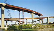 The Texas Department of Transportation had originally planned to complete construction of the entire 2002 CTTP in September 2007 but opened some sections of SH 45 North as early as October 31, 2006.
SH 45 Southeast is a 7.4 miles (11.9 km), tolled segment southeast of Austin, near Creedmoor, Texas
. Roughly paralleling Farm to Market Road 1327
, it is a four-lane, controlled-access facility that links SH 130 and US 183 to Interstate 35 north of Buda, Texas
. It completes the SH 45 eastern bypass loop around the Austin metropolitan area.
Originally planned as part of the 2002 CTTP, SH 45 Southeast became the subject of controversy, delaying development and necessitating it as a separate project. In 2006, an environmental advocacy group filed a lawsuit in an effort to move the alignment further south. By the summer of the same year, the Federal Highway Administration
approved a new environmental impact study affirming the existing alignment, and a federal judge dismissed the case, clearing the way for construction, which began in Summer 2007. SH 45 Southeast was opened to traffic on May 7, 2009.
SH 45 Southwest is a proposed link between the existing non-tolled SH 45 terminus at Loop 1 and Ranch to Market Road 1626 to the east. It could be tolled, especially if it included a freeway component. But if built, SH 45 Southwest would still require a segment between RM 1626 and I-35 to connect to the other tolled segments of the highway.
This missing link was one source of controversy surrounding the alignment of SH 45 Southeast. Opponents claimed the proximity of the southwestern and southeastern sections would create more pressure to connect the two and that, if built, the link would encourage development on or near environmentally sensitive land.
 State Highway 45 was originally designated in 1919 as a route from Bryan
to Jasper
. By 1933, large portions of the highway were still under construction along the proposed route. By 1938, the road was complete from Roan's Prairie to the Louisiana
border, with small portions remaining as a dirt road. Within the same year, the highway from Huntsville
to Jasper had been transferred to U.S. Highway 190, the stretch from Jasper to the Louisiana border transferred to SH 63
, and the section from Roan's Prairie to Huntsville redirected north to Crockett
. In 1960, the stretch from Huntsville to Crockett was transferred to SH 19
. The next year, the rest of SH 45 was canceled and transferred to SH 30
.
Austin, Texas
Austin is the capital city of the U.S. state of :Texas and the seat of Travis County. Located in Central Texas on the eastern edge of the American Southwest, it is the fourth-largest city in Texas and the 14th most populous city in the United States. It was the third-fastest-growing large city in...
that exists in two open segments. The official designation of SH 45 is such to form a complete loop around Austin, a distance of roughly 80 miles (128.7 km).
One segment is in southwest Austin and runs roughly southeast from Ranch to Market Road 1826
Ranch to Market Road 1826
Ranch to Market Road 1826 is a state-maintained ranch to market road located in Travis and Hays counties of the U.S. state of Texas.- Route description :...
to the southern terminus of Loop 1 (Mopac Expressway)
State Highway Loop 1 (Texas)
Loop 1 is a controlled-access highway which provides access to the west side of Austin in the U.S. state of Texas. It is named Mopac Expressway after the Missouri Pacific Railroad...
. The roadway is a divided, four-lane facility with a wide median intended to accommodate a future freeway, after which the current lanes would serve as frontage road
Frontage road
A frontage road is a non-limited access road running parallel to a higher-speed road, usually a freeway, and feeding it at appropriate points of access...
s.
The other segment is a toll road
Toll road
A toll road is a privately or publicly built road for which a driver pays a toll for use. Structures for which tolls are charged include toll bridges and toll tunnels. Non-toll roads are financed using other sources of revenue, most typically fuel tax or general tax funds...
that forms a backwards C-shape along the boundary of Travis and Williamson County before bending down along the eastern edge of the Austin metropolitan area where it shares its route with SH-130.
Toll road expansion
Before the 2002 Central Texas Turnpike Project (CTTP), SH 45 existed only as a short section of four-lane, divided highway in southwest Austin. The CTTP added a toll roadToll road
A toll road is a privately or publicly built road for which a driver pays a toll for use. Structures for which tolls are charged include toll bridges and toll tunnels. Non-toll roads are financed using other sources of revenue, most typically fuel tax or general tax funds...
that runs east from US 183 near Cedar Park
Cedar Park, Texas
Cedar Park is a city in Travis and Williamson counties in the U.S. state of Texas. According to the 2010 U.S. Census, the population is 48,937. The city is a major suburb of Austin, the center of which is approximately to the southeast, although Austin directly borders Cedar Park at the latter's...
, crosses I-35, bi-secting the La Frontera
La Frontera (Round Rock, Texas)
La Frontera is Round Rock's largest master-planned, multi-use commercial business-retail-housing center and is located at the northeast corner of SH 45 Toll Road and Interstate 35 in Round Rock, Texas within Williamson County, Texas. La Frontera is also located immediately across Interstate 35...
development, and meets SH 130
State Highway 130 (Texas)
State Highway 130, also known as SH 130 and Pickle Parkway, is a tollway from Interstate 35 in Georgetown to US 183 and SH 45 at Mustang Ridge in Central Texas. Portions south of Mustang Ridge are now under construction [As of 7/2010]. When completed, SH 130 will run in a corridor east and...
near Pflugerville
Pflugerville, Texas
Pflugerville is a city in Travis and Williamson counties in the U.S. state of Texas. The population was 16,335 at the 2000 census. A July 1, 2008 U.S. Census Bureau estimate placed the population at 39,653...
. South of this interchange, SH 45 is co-signed with SH 130 to US 183 just south of Austin-Bergstrom International Airport
Austin-Bergstrom International Airport
Austin-Bergstrom International Airport is a mixed-use commercial airport located southeast of the central business district of Austin, Texas, United States. It covers and has two runways and three helipads.The airport began passenger service on May 23, 1999...
. SH 45 then loops westward rejoining I-35 north of Buda
Buda, Texas
Buda is a city in Hays County, Texas, United States. The population was 2,404 at the 2000 census. City leaders estimated the population exceeded 5,100 in 2008 and the official 2009 Census Bureau estimate showed the population had increased to 7,784 as of July 1, 2009. The 2010 US Census listed...
.
SH 45 North is an approximately 13 miles (20.9 km) segment in the north Austin metropolitan area. The freeway's western terminus is at US 183 northwest of Austin in Cedar Park
Cedar Park, Texas
Cedar Park is a city in Travis and Williamson counties in the U.S. state of Texas. According to the 2010 U.S. Census, the population is 48,937. The city is a major suburb of Austin, the center of which is approximately to the southeast, although Austin directly borders Cedar Park at the latter's...
. For a distance, RM 620 travels concurrently with the frontage roads also designated as State Highway 45 (non-tolled). Heading east, the freeway intercepts Loop 1
State Highway Loop 1 (Texas)
Loop 1 is a controlled-access highway which provides access to the west side of Austin in the U.S. state of Texas. It is named Mopac Expressway after the Missouri Pacific Railroad...
's northern terminus, bisects La Frontera
La Frontera (Round Rock, Texas)
La Frontera is Round Rock's largest master-planned, multi-use commercial business-retail-housing center and is located at the northeast corner of SH 45 Toll Road and Interstate 35 in Round Rock, Texas within Williamson County, Texas. La Frontera is also located immediately across Interstate 35...
and crosses I-35. This particular segment ends at SH 130 near Pflugerville, but the SH 45 designation continues southward along SH 130.
SH 45 Southeast is a 7.4 miles (11.9 km), tolled segment southeast of Austin, near Creedmoor, Texas
Creedmoor, Texas
Creedmoor is a city in Travis County, Texas, United States. The population was 211 at the 2000 census, and 188 in the 2005 census estimate.-Geography:Creedmoor is located at , about 15 miles south of Austin....
. Roughly paralleling Farm to Market Road 1327
Farm to Market Road 1327
Farm to Market Road 1327 is a farm to market road in southern Travis County, Texas.- Route description :FM 1327 begins at Interstate 35 Exit #223 between Onion Creek and Buda in southern Travis County, near the Hays County line. This location also serves as the current western terminus of the ...
, it is a four-lane, controlled-access facility that links SH 130 and US 183 to Interstate 35 north of Buda, Texas
Buda, Texas
Buda is a city in Hays County, Texas, United States. The population was 2,404 at the 2000 census. City leaders estimated the population exceeded 5,100 in 2008 and the official 2009 Census Bureau estimate showed the population had increased to 7,784 as of July 1, 2009. The 2010 US Census listed...
. It completes the SH 45 eastern bypass loop around the Austin metropolitan area.
Originally planned as part of the 2002 CTTP, SH 45 Southeast became the subject of controversy, delaying development and necessitating it as a separate project. In 2006, an environmental advocacy group filed a lawsuit in an effort to move the alignment further south. By the summer of the same year, the Federal Highway Administration
Federal Highway Administration
The Federal Highway Administration is a division of the United States Department of Transportation that specializes in highway transportation. The agency's major activities are grouped into two "programs," the Federal-aid Highway Program and the Federal Lands Highway Program...
approved a new environmental impact study affirming the existing alignment, and a federal judge dismissed the case, clearing the way for construction, which began in Summer 2007. SH 45 Southeast was opened to traffic on May 7, 2009.
SH 45 Southwest is a proposed link between the existing non-tolled SH 45 terminus at Loop 1 and Ranch to Market Road 1626 to the east. It could be tolled, especially if it included a freeway component. But if built, SH 45 Southwest would still require a segment between RM 1626 and I-35 to connect to the other tolled segments of the highway.
This missing link was one source of controversy surrounding the alignment of SH 45 Southeast. Opponents claimed the proximity of the southwestern and southeastern sections would create more pressure to connect the two and that, if built, the link would encourage development on or near environmentally sensitive land.
History of the SH 45 designation
Bryan, Texas
Bryan is a city in Brazos County, Texas, United States. As of the 2010 census, the city had a total population of 76,201. It is the county seat of Brazos County and is located in the heart of the Brazos Valley . It shares its border with the city of College Station, which lies to its south...
to Jasper
Jasper, Texas
Jasper is the county seat of Jasper County, Texas, in the United States. The population was 8,247 at the 2000 census. Jasper is situated in the Deep East Texas subregion, about northeast of Houston. The city is best known for the 1998 murder of James Byrd, Jr., an event which gained national...
. By 1933, large portions of the highway were still under construction along the proposed route. By 1938, the road was complete from Roan's Prairie to the Louisiana
Louisiana
Louisiana is a state located in the southern region of the United States of America. Its capital is Baton Rouge and largest city is New Orleans. Louisiana is the only state in the U.S. with political subdivisions termed parishes, which are local governments equivalent to counties...
border, with small portions remaining as a dirt road. Within the same year, the highway from Huntsville
Huntsville, Texas
Huntsville is a city in and the county seat of Walker County, Texas, United States. The population was 35,508 at the 2010 census. It is the center of the Huntsville micropolitan area....
to Jasper had been transferred to U.S. Highway 190, the stretch from Jasper to the Louisiana border transferred to SH 63
State Highway 63 (Texas)
State Highway 63 or SH 63 is a highway in east Texas that runs from Zavalla through Jasper, continuing east to the Louisiana border. The highway was originally designated by 1926 along the easternmost branch of previously numbered SH 7 from Zavalla southeast to Bon Wier. By 1938, the section from...
, and the section from Roan's Prairie to Huntsville redirected north to Crockett
Crockett, Texas
Crockett is a city in Houston County, Texas, in the United States. As of the 2000 census, the city population was 7,141. It is the county seat of Houston County.- History :...
. In 1960, the stretch from Huntsville to Crockett was transferred to SH 19
State Highway 19 (Texas)
State Highway 19, or SH 19, runs from Huntsville to Paris in east Texas. It is a two-lane freeway near Huntsville.-History:SH 19 was one of the original 26 Texas state highways proposed in 1917. The original proposal was for it to run from the Texas/Oklahoma border north of Paris to Houston. By...
. The next year, the rest of SH 45 was canceled and transferred to SH 30
State Highway 30 (Texas)
State Highway 30, or SH 30, runs from Business SH 6-R in College Station via Roans Prairie to SH 19 in Huntsville. This route was designated in 1961, replacing SH 45...
.
Exit list
| County | Location | # Exit number An exit number is a number assigned to a road junction, usually an exit from a freeway. It is usually marked on the same sign as the destinations of the exit, as well as a sign in the gore.... |
Destinations | Notes |
|---|---|---|---|---|
| Williamson Williamson County, Texas Williamson County is a county located on both the Edwards Plateau to the west, consisting of rocky terrain and hills, and Blackland Prairies in the east consising of rich, fertile farming land, The two areas are roughly bisected by Interstate 35... |
Austin Austin, Texas Austin is the capital city of the U.S. state of :Texas and the seat of Travis County. Located in Central Texas on the eastern edge of the American Southwest, it is the fourth-largest city in Texas and the 14th most populous city in the United States. It was the third-fastest-growing large city in... |
Westbound exit, eastbound entrance | ||
| Westbound exit, eastbound entrance | ||||
| Lake Creek Pkwy | ||||
| McNeil Rd | No Westbound exit | |||
| West end of Loop 1 overlap | ||||
| Round Rock Round Rock, Texas Round Rock is a city in Travis and Williamson counties in the U.S. state of Texas. It is part of the metropolitan area. The 2010 census places the population at 99,887.... |
La Frontera Blvd, CR 172 | |||
| East end of Loop 1 overlap | ||||
| Greenlawn Blvd | ||||
| A.W. Grimes Blvd | ||||
| Donnell Dr | No westbound exit | |||
| Travis Travis County, Texas As of 2009, the U.S. census estimates there were 1,026,158 people, 320,766 households, and 183,798 families residing in the county. The population density was 821 people per square mile . There were 335,881 housing units at an average density of 340 per square mile... |
Pflugerville Pflugerville, Texas Pflugerville is a city in Travis and Williamson counties in the U.S. state of Texas. The population was 16,335 at the 2000 census. A July 1, 2008 U.S. Census Bureau estimate placed the population at 39,653... |
Heatherwilde Blvd | No westbound exit | |
| North end of SH 130 concurrency | ||||
| 429 | Pflugerville Pkwy | Northbound exit and southbound entrance | ||
| 431 | Pecan St | |||
| 432 | Cameron Rd | Southbound exit and northbound entrance | ||
| 435 | Gregg Manor Rd | Northbound exit and southbound entrance | ||
| Austin Austin, Texas Austin is the capital city of the U.S. state of :Texas and the seat of Travis County. Located in Central Texas on the eastern edge of the American Southwest, it is the fourth-largest city in Texas and the 14th most populous city in the United States. It was the third-fastest-growing large city in... |
436 | |||
| 437 | ||||
| 439 | Blue Bluff Rd | No northbound exit | ||
| 441 | ||||
| 444 | ||||
| 446 | Harold Green Rd | |||
| Austin Austin, Texas Austin is the capital city of the U.S. state of :Texas and the seat of Travis County. Located in Central Texas on the eastern edge of the American Southwest, it is the fourth-largest city in Texas and the 14th most populous city in the United States. It was the third-fastest-growing large city in... |
449 | |||
| 450 | Pearce Ln | |||
| 451 | Elroy Rd | |||
| 453 | ||||
| 455 | Moore Rd | |||
| Mustang Ridge Mustang Ridge, Texas Mustang Ridge is a city in Caldwell, and Travis Counties in the U.S. state of Texas. The population was 785 at the 2000 census.-Geography:Mustang Ridge is located at .... |
457 | Maha Loop | ||
| 458 | South end of SH 130 concurrency | |||
| Creedmoor Creedmoor, Texas Creedmoor is a city in Travis County, Texas, United States. The population was 211 at the 2000 census, and 188 in the 2005 census estimate.-Geography:Creedmoor is located at , about 15 miles south of Austin.... |
||||
| North Turnersville Road | ||||
| , San Antonio | ||||
| Current gap in highway | ||||
| Austin Austin, Texas Austin is the capital city of the U.S. state of :Texas and the seat of Travis County. Located in Central Texas on the eastern edge of the American Southwest, it is the fourth-largest city in Texas and the 14th most populous city in the United States. It was the third-fastest-growing large city in... |
||||