

U.S. Route 15 in Maryland
Encyclopedia
U.S. Route 15 (US 15) is a part of the U.S. Highway System that runs from Walterboro, South Carolina
to Painted Post, New York
. In Maryland
, the highway runs 37.85 miles (60.9 km) from the Virginia
state line at the Potomac River
in Point of Rocks
north to the Pennsylvania
state line near Emmitsburg
. US 15 is the primary north–south highway of Frederick County
. The highway connects the county seat
of Frederick
with Point of Rocks and Leesburg
to the south and with Thurmont
, Emmitsburg, and Gettysburg
to the north. US 15 is a four-lane divided highway throughout the state except for the portion between the Point of Rocks Bridge and the highway's junction with US 340
near Jefferson
. The U.S. Highway is a freeway along its concurrency
with US 340 and through Frederick, where the highway meets US 40
and Interstate 70
(I-70).
US 15 is the descendent of a pair of turnpikes that connected Frederick with Emmitsburg to the north and Buckeystown
to the south. These turnpikes were reconstructed as state roads in the 1910s north of Frederick and in the early 1920s from Frederick south to Tuscarora
. When US 15 was assigned in 1927, the Tuscarora – Point of Rocks highway had yet to be improved; this section was paved in the early 1930s. The modern Point of Rocks Bridge was built in the late 1930s after its predecessor was destroyed in a flood. The Frederick Freeway was constructed in the 1950s. US 15 was relocated to part of the freeway; the old route of the U.S. Highway through downtown Frederick became part of Maryland Route 355 (MD 355). US 15's present highway between Point of Rocks and Jefferson was constructed in the late 1960s; the old road south of Frederick was replaced with MD 28
and MD 85
. North of Frederick, the U.S. Highway bypassed Thurmont and Emmitsburg in the late 1950s and mid-1960s, respectively. US 15 was upgraded to a divided highway north of Frederick in the early 1980s.
designated the highway the 115th Infantry Regiment Memorial Highway; a marker honoring the 115th Infantry Regiment was completed in the median of US 15 in Emmitsburg in July 2006. All of US 15 except the portion between Catoctin Furnace
and Thurmont is part of the Catoctin Mountain Scenic Byway, which was designated a National Scenic Byway
in September 2005. The entire length of the highway in Maryland is part of the National Highway System
.
, Pine Rock in Maryland and Furnace Mountain
in Loudoun County, Virginia
. The highway crosses the river on the Point of Rocks Bridge, a two-lane, eight-span camelback truss bridge that also passes over the Chesapeake and Ohio Canal
and CSX
's Metropolitan Subdivision on the Maryland side of the river. Just north of the bridge, US 15 meets the western terminus of MD 28 (Clay Street), which serves as the main street of the community of Point of Rocks. The U.S. Highway heads north as a two-lane controlled-access road that passes through a mix of farmland and forest on the eastern flank of Catoctin Mountain. North of its roundabout
at MD 464
(Point of Rocks Road), US 15 has only two intersections, with Basford Road and Mountville Road, before passing under Elmer Derr Road and reaching a partial interchange with US 340 (Jefferson National Pike) east of Jefferson. There is no direct access from northbound US 15 to westbound US 340 or from eastbound US 340 to southbound US 15.
 US 15 and US 340 run concurrently northeast toward Frederick as a four-lane freeway. The two highways have a diamond interchange
with Mt. Zion Road and cross over Ballenger Creek
. On the southwest side of Frederick, the freeway has a partial interchange with I-70 (Eisenhower Memorial Highway), a folded diamond interchange with MD 180
(Jefferson Pike), and a partial cloverleaf interchange with the Frederick Freeway, which carries US 40 through the interchange. US 340's eastern terminus is within the third interchange, where US 15 exits north onto the Frederick Freeway and Jefferson Street continues east toward downtown Frederick.
US 15 continues north concurrent with US 40 along the six-lane Frederick Freeway. US 40 exits the freeway at a partial cloverleaf interchange with Patrick Street, which heads east toward downtown Frederick and west through the heavily commercialized Golden Mile. US 15 crosses Carroll Creek
and continues north with four lanes through folded diamond interchanges with Rosemont Avenue, 7th Street, and Motter Avenue. All three streets provide access to Fort Detrick
, home of the United States Army Medical Research Institute of Infectious Diseases
. In addition, Rosemont Avenue leads to Hood College
and Motter Avenue connects the freeway with Frederick Community College
. The Frederick Freeway ends at US 15's partial interchange with MD 26
(Liberty Road).
. The highway parallels the Monocacy River
and has a junction with Biggs Ford Road on its way north to the hamlet of Hansonville, where the U.S. Highway intersects Old Frederick Road. US 15 crosses Fishing Creek to the west of Lewistown
and is closely paralleled on the west by Auburn Road as the highway gradually approaches the eastern flank of Catoctin Mountain. At the northern end of Auburn Road, MD 806
(Catoctin Furnace Road) begins to parallel the northbound side of the U.S. Highway, which follows the eastern boundary of Cunningham Falls State Park
just west of the village of Catoctin Furnace. Access to the main section of the state park is provided by Catoctin Hollow Road, which intersects the southbound lanes of US 15 and follows Little Hunting Creek up the mountain. The park's Manor Area is accessible from US 15 a short distance north of Catoctin Hollow Road.
North of its intersection with Blue Mountain Road and Pryor Road, US 15 leaves the park boundary and enters the town of Thurmont. The U.S. Highway has a diamond interchange with unnamed and unsigned
MD 15C that leads to the northern end of MD 806 and to Frederick Road, which serves a commercial area south of downtown Thurmont. US 15 continues north to a folded diamond interchange with MD 77
(Main Street) where the highway also crosses Hunting Creek; MD 77 follows the creek up the mountain as Foxville Road toward Catoctin Mountain Park
. The highway intersects Sandy Spring Lane (unsigned MD 15D) and crosses over the Maryland Midland Railroad. US 15 leaves the town of Thurmont and meets MD 550
(Church Street) at a diamond interchange before crossing Owens Creek, which MD 550 follows up the mountain as Sabillasville Road. The U.S. Highway heads northeast through farmland and meets the northern end of MD 76
(Motters Station Road) before bisecting the campus of Mount St. Mary's University. The main part of the campus and National Shrine Grotto of Our Lady of Lourdes are located to the west of the highway; the athletic complex, which includes Knott Arena
, is to the east.
North of Mount St. Mary's University, US 15 meets the southern end of unsigned US 15 Business
(Seton Avenue) at a directional crossover intersection that also serves Old Frederick Road; U-turn ramps on either side of the intersection provide the missing movements. The U.S. Highway crosses Toms Creek and Flat Run along the eastern side of the town of Emmitsburg before its interchange with MD 140
(Main Street). MD 140 is accessed via a pair of right-in/right-out
interchanges with Emmit Gardens Drive, which is unsigned MD 904H on the northbound side of US 15 and MD 904F on the southbound side. North of MD 140, the southbound direction of US 15 has a welcome center, the Mason and Dixon Discovery Center. US 15's last intersection in Maryland is with the northern end of US 15 Business (Seton Avenue) and Welty Road, which leads to Old Gettysburg Road. North of the intersection, US 15 becomes a freeway that continues across the Pennsylvania state line as the U.S. highway's bypass of Gettysburg.
followed US 15's current corridor from Frederick north to near Harrisburg
. No U.S. Highway connected Frederick and Leesburg via Point of Rocks. By the end of 1927, US 240 was reduced to a Washington–Frederick highway and US 15 connected Point of Rocks and Emmitsburg via Frederick as it does today.
(MDSRC) designated highways to be improved as part of a state road system in 1909, the Frederick–Emmitsburg highway was included in the new system. MDSRC originally planned to build the state road north from the city of Frederick along the Frederick and Opossumtown Turnpike, then turn east along Hayward Road to meet the Frederick and Emmitsburg Turnpike at Harmony Grove.
MDSRC purchased the Frederick and Emmitsburg Turnpike from its operating company in 1911. The first section of the turnpike to be rebuilt as a modern road was between Tuscarora Creek north of Frederick and just north of Sundays Lane near Hansonville in 1911. The old turnpike was resurfaced as a 14 feet (4.3 m) macadam road from Lewistown to Thurmont in 1914 and from Harmony Grove to Lewistown in 1915. The Gettysburg Road from Emmitsburg to the Pennsylvania state line was also paved in 1915. The gaps between Thurmont and Emmitsburg and between the city of Frederick and Harmony Grove were resurfaced between 1915 and 1919; the Frederick – Harmony Grove road followed the turnpike right-of-way north from Worman's Mill rather than the 1910 planned route via Opossumtown Pike.
The right-of-way of the Frederick and Buckeystown Turnpike was resurfaced with macadam by 1921. The remainder of Buckeystown Pike was paved as a 15 feet (4.6 m) concrete road from south of Buckeystown to around Lily Pons Road in 1918 and 1919 and south of Lily Pons Road to just north of the modern MD 28 junction in Tuscarora by 1921. The concrete highway was extended south through the MD 28 junction to modern MD 28's junction with Nolands Ferry Road by 1923. That same year, Emmitsburg Pike was paved through Thurmont. In 1926, MDSRC assumed maintenance of and resurfaced Market Street with asphalt from the city of Frederick between the south city limit at New Design Road (now Stadium Drive) to the north city limit at 9th Street. The commission also replaced Buckeystown Pike's covered bridge
at Ballenger Creek with the modern concrete arch bridge that year. US 15 was widened to a width of 20 feet (6.1 m) from Frederick to the Pennsylvania state line around 1930. The highway from Tuscarora to Point of Rocks was constructed as a concrete road in three stages starting in 1929, when the paved highway was extended west from Nolands Ferry Road to west of New Design Road. The second section of the new highway was started in 1930. The third segment was finished in 1933, which completed the paving of US 15 in Maryland. Around 1938, the U.S. Highway was resurfaced with asphalt from Emmitsburg to the Pennsylvania state line and from the south end of Frederick to Evergreen Point; in addition, a grade separation was constructed with the Western Maryland Railway
in Thurmont.
to a blast furnace to process the area's iron ore. This bridge, which also carried wagons and horses, was destroyed on June 9, 1861 by Confederate forces
under General Turner Ashby
, the same day the bridge at Brunswick was destroyed. The second bridge at Point of Rocks was an iron bridge constructed in 1889. US 15 originally followed Commerce Street and Canal Road, which is now used to access the Chesapeake and Ohio Canal National Historical Park, through an at-grade crossing of the B&O Railroad to the Maryland end of the bridge, which crossed the river immediately to the east of the modern bridge. The 1889 iron bridge was swept away in the March 1936 flood that also destroyed the Potomac River crossings at Harpers Ferry
, Shepherdstown
, and Hancock
.
In November 1936, MDSRC put together a plan to replace the Potomac River bridges at Hancock, Shepherdstown, and Point of Rocks. The Point of Rocks Bridge became the first of the three crossings to be started when construction began March 25, 1937; the bridge's concrete piers were completed and the piers of the old bridge were removed from the river by September of that year. The new bridge and its approaches, which crossed over the B&O Railroad on the Maryland side, opened December 26, 1937. The camelback truss bridge spans 1689 feet (514.8 m) and has a 24 feet (7.3 m) roadway and a pair of 3 foot (0.9144 m) sidewalks. US 15 followed a temporary approach to the new bridge along Commerce Street that remained vulnerable to major floods. The U.S. Highway was moved to higher ground on Clay Street when the highway was reconstructed and widened from Point of Rocks to Tuscarora in 1949.
The first section of the Frederick Freeway opened from US 40 (now MD 144) east of Frederick to a temporary half-cloverleaf interchange with Patrick Street in 1956; this section featured a cloverleaf interchange with US 340. The remainder of the Frederick Freeway from Patrick Street to MD 26 was placed under construction in 1956. The highway was constructed as a two-lane freeway from just south of its interchange with Rosemont Avenue to its northern end near Hayward Road, where the freeway tied into existing US 15 at Harmony Grove. The freeway north of Patrick Street featured interchanges with Rosemont Avenue, Motter Avenue, and a westward extension of MD 26. When the Frederick Freeway opened in 1959, US 15 was moved to Washington National Pike north of Buckeystown Pike and north through Frederick along the Frederick Freeway. Market Street north of Evergreen Point through downtown Frederick to US 15 north of the city became a northward extension of MD 355; the section of Buckeystown Pike from the freeway to Evergreen Point became a section of MD 806.
In 1960, US 15 from the MD 26 interchange to Harmony Grove was expanded to a divided highway. The Frederick Freeway gained exit numbers in 1965, the same year the highway's interchange with 7th Street was added. The exit numbers ranged from 1 at the freeway's interchange with MD 144 east of Frederick to 9 at the highway's interchange with MD 26; the 7th Street interchange became exit 7A. The two-lane section of the freeway was expanded to its present four-lane configuration in 1969, the same year the US 340 freeway was completed between Jefferson and Frederick. US 15's present alignment from Point of Rocks to US 340 was also under construction by 1969. When the new highway opened in 1970, US 15 was moved to the new highway and joined US 340 in a concurrency along Jefferson National Pike from Jefferson to the Frederick Freeway. The old section of US 15 from Point of Rocks to Tuscarora became a westward extension of MD 28. Buckeystown Pike from MD 28 to Washington National Pike was designated MD 85, which was extended north to MD 355 the following year. The U.S. Highway's interchange with Mt. Zion Road opened in 1972.
Several other sections of US 15 were bypassed in the 1960s. The highway bypassed Lewistown in 1962, leaving behind its old alignment of Hessong Bridge Road and Angleberger Road, which became a section of MD 806. Construction on the U.S. Highway's bypass of Emmitsburg began in 1963. The following year, the portion of US 15 from the northern end of the bypass to the Pennsylvania state line opened contemporaneously with US 15's bypass of Gettysburg. The Emmitsburg bypass was completed in 1965; the old road through the town was designated US 15 Business by 1967. MD 140's overpass of US 15 was constructed in 1971; the old alignment of MD 140 was used for interchange ramps between the two highways.
US 15 was expanded to a divided highway north of Frederick between 1972 and 1985. The U.S. Highway was expanded to four lanes from MD 355 at Harmony Grove to Angleberger Road in Lewistown in 1973. Four-laning of US 15 continued in 1981 when the highway was expanded from the intersection with St. Anthony and Orndorff roads south of Mount St. Mary's University to just south of the Pennsylvania state line near Emmitsburg. This section of divided highway was extended south through the MD 550 interchange in 1983. As part of this project, the oblique intersection with MD 806 on the north side of Thurmont was removed. MD 806 was moved onto Albert Staub Road, which was extended north over a new crossing of Owens Creek to its present terminus at Roddy Creek Road, where local traffic could access US 15 at a perpendicular intersection. The two-lane highway between Lewistown and MD 550 was expanded to a four-lane divided highway in 1985. The MD 77 interchange was completed with the construction of the southbound US 15 ramps in the southwest quadrant of the junction. A third interchange was added on the south side of Thurmont as a connector between US 15 and MD 806 in 1985 as well. US 15's expansion to a four-lane divided highway north of Frederick was completed in 1989 when the piece of highway at the Pennsylvania state line was expanded to four lanes contemporaneous with the four-laning of the Gettysburg bypass.
to north of US 15's intersection with Biggs Ford Road north of Frederick. The study was started by the Maryland State Highway Administration
(MDSHA) and Maryland Transportation Authority
in the mid-1990s to examine upgrades to the highway and transit infrastructure within the corridor. As part of another long-term project initiated by the I-70 Corridor Planning Study, Jefferson National Pike's interchange with I-70, which was constructed with two ramps in 1969, received two ramps from eastbound I-70 in 1997; that same year, access from northbound US 15 and US 340 to westbound I-70 was added at the Frederick Freeway interchange. Exit numbers on US 15's portions of Jefferson National Pike and the Frederick Freeway were changed to their present numbers in 2002. The interchange between Jefferson National Pike and the Frederick Freeway was transformed from a cloverleaf to a partial cloverleaf interchange in 2004. Access between US 15 and the northern end of MD 355, then named Wormans Mill Road, was removed in 2006, the same year a ramp was added from westbound MD 26 to northbound US 15. The roundabout at the US 15–MD 464 intersection in Point of Rocks was built in 2009.
There are two upcoming construction projects involving US 15 in Frederick. MDSHA plans to replace Motter Avenue's bridge over US 15 because the concrete deck of the present bridge is deteriorating and the four-lane width of the bridge is insufficient for the traffic it carries. The new bridge will have four through traffic lanes and a continuous left turn lane. The replacement bridge will also be long enough to accommodate future widening of US 15. Engineering and right-of-way acquisition are underway; construction is expected to begin in spring 2012 and last three years. The new bridge will be built in two sections: one half of the bridge will be constructed immediately to the north of the present bridge, traffic will be moved to the half-bridge and the old bridge removed, and the other half of the new bridge will be constructed in place of the removed bridge.
In 2011, MDSHA completed a study to examine constructing an interchange at Monocacy Boulevard on the north side of Frederick to replace the present directional crossover intersection. Design work is underway on a diamond interchange with the municipal highway, which serves as a circumferential arterial in the northeastern part of the city. Monocacy Boulevard will be extended west to north–south Thomas Johnson Drive and meet the eastern end of Christophers Crossing, which is a circumferential boulevard throughout northwestern Frederick. As part of this project, US 15's intersection with Hayward Road will be removed, resulting in the northern end of US 15's freeway section being extended from MD 26 to Tuscarora Creek.
.
{| class=wikitable
!scope=col|Location
!scope=col|Mile
!scope=col|Exit
!scope=col|Destinations
!scope=col|Notes
|-
|rowspan=3|Point of Rocks
|0.00
|
|
|Southern terminus of US 15 in Maryland; Virginia
state line at Potomac River
|-
|0.37
|
|
|
|-
|1.40
|
|
|Roundabout
|-
|Jefferson
|7.22
|
|
|Partial interchange; no direct access from northbound US 15 to westbound US 340 or from eastbound US 340 to southbound US 15; south end of concurrency with US 340
|-
|
|8.84
|
|Mt. Zion Road
|Diamond interchange
|-
|rowspan=8|Frederick
|11.30
|10
|
|I-70 Exit 52; no exit southbound
|-
|11.54
|11
|
|
|-
|11.93
|12
|
|Partial cloverleaf interchange; split into exits 12A (I-70) and 12B (US 15 / US 40) northbound; no exit number southbound; northern terminus of US 340; south end of concurrency with US 40
|-
|12.63
|13
|
|North end of concurrency with US 40
|-
|13.40
|14
|Rosemont Avenue
|
|-
|13.91
|15
|7th Street
|
|-
|14.60
|16
|Motter Avenue
|
|-
|15.14
|17
|
|No access from southbound US 15 to eastbound MD 26
|-
|
|18.02
|
|Biggs Ford Road east – Walkersville
|Directional crossover intersection; unsigned US 15A
|-
|rowspan=2|Catoctin Furnace
|24.64
|
|
|
|-
|26.96
|
|Blue Mountain Road east / Pryor Road west
|Blue Mountain Road is unsigned US 15G
|-
|rowspan=3|Thurmont
|27.83
|
|
|Diamond interchange; crossroad is unnamed and unsigned MD 15C
|-
|28.60
|
|
|Folded diamond interchange
|-
|29.42
|
|
|
|-
|rowspan=5|Emmitsburg
|33.53
|
|
|
|-
|35.02
|
|
|Directional crossover intersection; US 15 Business is unsigned
|-
|36.60
|
|
|Access to MD 140 provided via right-in/right-out
interchanges with Emmit Gardens Drive, which is unsigned MD 904H (northbound) and MD 904F (southbound)
|-
|37.38
|
|
|No direct access from northbound US 15 Business to northbound US 15
|-
|37.85
|
|
|Northern terminus of US 15 in Maryland; Pennsylvania
state line
business route of US 15 in Maryland. The highway runs 2.34 miles (3.8 km) between intersections with US 15 within Emmitsburg. US 15 Business serves the St. Joseph's College and Mother Seton Shrine
campuses, which are home to several emergency management institutions and a shrine dedicated to Elizabeth Ann Seton
, the first person born in the United States to be canonized
by the Roman Catholic Church
. US 15 Business was assigned in the mid-1960s after US 15 bypassed Emmitsburg.
Walterboro, South Carolina
Walterboro is a city in Colleton County, South Carolina, United States. The population was 5,153 at the 2000 census . It is the county seat of Colleton County.-History:...
to Painted Post, New York
Painted Post, New York
Painted Post is a village in Steuben County, New York, United States. The village is in the town of Erwin, west of the city of Corning. The population was 1,842 at the 2000 census. The name comes from a painted and carved post found by explorers at the junction of three local rivers...
. In Maryland
Maryland
Maryland is a U.S. state located in the Mid Atlantic region of the United States, bordering Virginia, West Virginia, and the District of Columbia to its south and west; Pennsylvania to its north; and Delaware to its east...
, the highway runs 37.85 miles (60.9 km) from the Virginia
Virginia
The Commonwealth of Virginia , is a U.S. state on the Atlantic Coast of the Southern United States. Virginia is nicknamed the "Old Dominion" and sometimes the "Mother of Presidents" after the eight U.S. presidents born there...
state line at the Potomac River
Potomac River
The Potomac River flows into the Chesapeake Bay, located along the mid-Atlantic coast of the United States. The river is approximately long, with a drainage area of about 14,700 square miles...
in Point of Rocks
Point of Rocks, Maryland
Point of Rocks is a community in Frederick County, Maryland. It is named for the striking rock formation on the adjacent Catoctin Mountain, which were formed by the Potomac River cutting through the ridge in a water gap, a typical formation in the Ridge-and-Valley Appalachians...
north to the Pennsylvania
Pennsylvania
The Commonwealth of Pennsylvania is a U.S. state that is located in the Northeastern and Mid-Atlantic regions of the United States. The state borders Delaware and Maryland to the south, West Virginia to the southwest, Ohio to the west, New York and Ontario, Canada, to the north, and New Jersey to...
state line near Emmitsburg
Emmitsburg, Maryland
-Demographics:As of the census of 2000, there were 2,290 people, 811 households, and 553 families residing in the town. The population density was 1,992.9 people per square mile . There were 862 housing units at an average density of 750.2 per square mile...
. US 15 is the primary north–south highway of Frederick County
Frederick County, Maryland
Frederick County is a county located in the western part of the U.S. state of Maryland, bordering the southern border of Pennsylvania and the northeastern border of Virginia. As of the 2010 Census, the population was 233,385....
. The highway connects the county seat
County seat
A county seat is an administrative center, or seat of government, for a county or civil parish. The term is primarily used in the United States....
of Frederick
Frederick, Maryland
Frederick is a city in north-central Maryland. It is the county seat of Frederick County, the largest county by area in the state of Maryland. Frederick is an outlying community of the Washington-Arlington-Alexandria, DC-VA-MD-WV Metropolitan Statistical Area, which is part of a greater...
with Point of Rocks and Leesburg
Leesburg, Virginia
Leesburg is a historic town in, and county seat of, Loudoun County, Virginia, United States of America. Leesburg is located west-northwest of Washington, D.C. along the base of the Catoctin Mountain and adjacent to the Potomac River. Its population according the 2010 Census is 42,616...
to the south and with Thurmont
Thurmont, Maryland
Thurmont is a town in Frederick County, Maryland, United States. The population was 5,588 at the 2000 census. The town is located in the northern part of Frederick County , approximately ten miles from the Pennsylvania border, along U.S. Highway 15...
, Emmitsburg, and Gettysburg
Gettysburg, Pennsylvania
Gettysburg is a borough that is the county seat, part of the Gettysburg Battlefield, and the eponym for the 1863 Battle of Gettysburg. The town hosts visitors to the Gettysburg National Military Park and has 3 institutions of higher learning: Lutheran Theological Seminary, Gettysburg College, and...
to the north. US 15 is a four-lane divided highway throughout the state except for the portion between the Point of Rocks Bridge and the highway's junction with US 340
U.S. Route 340 in Maryland
U.S. Route 340 is a part of the U.S. Highway System that runs from Greenville, Virginia to Frederick, Maryland. In Maryland, the U.S. highway runs from the Virginia state line at the Potomac River at Sandy Hook east to its northern terminus at US 15 and US 40 in Frederick...
near Jefferson
Jefferson, Maryland
Jefferson is an unincorporated community located in Frederick County, Maryland, established in 1774, incorporated as a town in 1831. However, a year later, in 1832, the citizens of the town decided that municipal government was unnecessary, thus, it was disincorporated.- History of Jefferson...
. The U.S. Highway is a freeway along its concurrency
Concurrency (road)
A concurrency, overlap, or coincidence in a road network is an instance of one physical road bearing two or more different highway, motorway, or other route numbers...
with US 340 and through Frederick, where the highway meets US 40
U.S. Route 40 in Maryland
U.S. Route 40 in the U.S. state of Maryland runs from western Maryland to Cecil County in the state's northeastern corner. With a total length of over , it is the longest numbered highway in Maryland. Almost half of the road overlaps with Interstate 68 or Interstate 70, while the old alignment...
and Interstate 70
Interstate 70 in Maryland
Interstate 70 is a part of the Interstate Highway System that runs from Cove Fort, Utah to Baltimore, Maryland. In Maryland, the Interstate Highway runs from the Pennsylvania state line in Hancock east to the Interstate's eastern terminus near its junction with I-695 at a park and ride in...
(I-70).
US 15 is the descendent of a pair of turnpikes that connected Frederick with Emmitsburg to the north and Buckeystown
Buckeystown, Maryland
Buckeystown is an unincorporated community in Frederick County, Maryland, United States. Buckeystown Historic District and Buckingham House and Industrial School Complex were listed on the National Register of Historic Places in 1982. Carrollton Manor was listed in 1997.Current member of Congress...
to the south. These turnpikes were reconstructed as state roads in the 1910s north of Frederick and in the early 1920s from Frederick south to Tuscarora
Tuscarora, Maryland
Tuscarora is a small village in southern Frederick County, Maryland. Maryland Route 28 runs through the village. The community was named for Tuscarora Creek that runs in the area. There is an old, small post office that is in the area along Route 28. The area was formerly named Licksville after...
. When US 15 was assigned in 1927, the Tuscarora – Point of Rocks highway had yet to be improved; this section was paved in the early 1930s. The modern Point of Rocks Bridge was built in the late 1930s after its predecessor was destroyed in a flood. The Frederick Freeway was constructed in the 1950s. US 15 was relocated to part of the freeway; the old route of the U.S. Highway through downtown Frederick became part of Maryland Route 355 (MD 355). US 15's present highway between Point of Rocks and Jefferson was constructed in the late 1960s; the old road south of Frederick was replaced with MD 28
Maryland Route 28
Maryland Route 28 is a state highway in the U.S. state of Maryland. The state highway runs from U.S. Route 15 in Point of Rocks east to MD 182 in Norwood. The western portion of MD 28 is a rural highway connecting several villages in southern Frederick County and western Montgomery County...
and MD 85
Maryland Route 85
Maryland Route 85 is a state highway in the U.S. state of Maryland. Known as Buckeystown Pike, the state highway runs from MD 28 in Tuscarora north to the Frederick city limit north of Interstate 70 , where the highway continues north as East Street. MD 85 connects Tuscarora and Buckeystown in...
. North of Frederick, the U.S. Highway bypassed Thurmont and Emmitsburg in the late 1950s and mid-1960s, respectively. US 15 was upgraded to a divided highway north of Frederick in the early 1980s.
Route description
US 15 has several official designations throughout its course in Maryland. The U.S. Highway is known as Catoctin Mountain Highway from the Virginia state line at Point of Rocks north to US 340 near Jefferson and from MD 26 in Frederick north to the Pennsylvania state line near Emmitsburg. US 15 is also part of Jefferson National Pike along its freeway concurrency with US 340 and the Frederick Freeway between US 340 and MD 26. In July 2004, the Maryland General AssemblyMaryland General Assembly
The Maryland General Assembly is the state legislature of the U.S. state of Maryland. It is a bicameral body. The upper chamber, the Maryland State Senate, has 47 representatives and the lower chamber, the Maryland House of Delegates, has 141 representatives...
designated the highway the 115th Infantry Regiment Memorial Highway; a marker honoring the 115th Infantry Regiment was completed in the median of US 15 in Emmitsburg in July 2006. All of US 15 except the portion between Catoctin Furnace
Catoctin Furnace, Maryland
Catoctin Furnace is an unincorporated community in Frederick County, Maryland, United States. It is the site of the Catoctin Furnace Historic District.-References:...
and Thurmont is part of the Catoctin Mountain Scenic Byway, which was designated a National Scenic Byway
National Scenic Byway
A National Scenic Byway is a road recognized by the United States Department of Transportation for its archeological, cultural, historic, natural, recreational, and/or scenic qualities. The program was established by Congress in 1991 to preserve and protect the nation's scenic but often...
in September 2005. The entire length of the highway in Maryland is part of the National Highway System
National Highway System (United States)
The National Highway System is a network of strategic highways within the United States, including the Interstate Highway System and other roads serving major airports, ports, rail or truck terminals, railway stations, pipeline terminals and other strategic transport facilities.Individual states...
.
Point of Rocks to Frederick
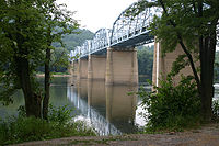
US 15 enters Maryland at Point of Rocks, named for the pair of mountain peaks between which the Potomac River cuts through Catoctin MountainCatoctin Mountain
Catoctin Mountain, along with the geologically associated Bull Run Mountains, comprises the easternmost mountain ridge of the Blue Ridge Mountains, which are in turn a part of the Appalachian Mountains range...
, Pine Rock in Maryland and Furnace Mountain
Furnace Mountain (Virginia)
Furnace Mountain is the tallest peak of Catoctin Mountain in Loudoun County, Virginia. It rises steeply from the southern banks of the Potomac River across from Point of Rocks, Maryland and continues southward for , reaching an elevation of before falling to a gap between it and an unnamed peak of...
in Loudoun County, Virginia
Loudoun County, Virginia
Loudoun County is a county located in the Commonwealth of Virginia, and is part of the Washington Metropolitan Area. As of the 2010 U.S. Census, the county is estimated to be home to 312,311 people, an 84 percent increase over the 2000 figure of 169,599. That increase makes the county the fourth...
. The highway crosses the river on the Point of Rocks Bridge, a two-lane, eight-span camelback truss bridge that also passes over the Chesapeake and Ohio Canal
Chesapeake and Ohio Canal
The Chesapeake and Ohio Canal, abbreviated as the C&O Canal, and occasionally referred to as the "Grand Old Ditch," operated from 1831 until 1924 parallel to the Potomac River in Maryland from Cumberland, Maryland to Washington, D.C. The total length of the canal is about . The elevation change of...
and CSX
CSX Transportation
CSX Transportation operates a Class I railroad in the United States known as the CSX Railroad. It is the main subsidiary of the CSX Corporation. The company is headquartered in Jacksonville, Florida, and owns approximately 21,000 route miles...
's Metropolitan Subdivision on the Maryland side of the river. Just north of the bridge, US 15 meets the western terminus of MD 28 (Clay Street), which serves as the main street of the community of Point of Rocks. The U.S. Highway heads north as a two-lane controlled-access road that passes through a mix of farmland and forest on the eastern flank of Catoctin Mountain. North of its roundabout
Roundabout
A roundabout is the name for a road junction in which traffic moves in one direction around a central island. The word dates from the early 20th century. Roundabouts are common in many countries around the world...
at MD 464
Maryland Route 464
Maryland Route 464 is a state highway in the U.S. state of Maryland. Known for most of its length as Point of Rocks Road, the state highway runs from MD 17 and MD 79 in Rosemont east to Ballenger Creek Pike in Point of Rocks. MD 464 connects Brunswick with U.S. Route 15 in Point of Rocks in...
(Point of Rocks Road), US 15 has only two intersections, with Basford Road and Mountville Road, before passing under Elmer Derr Road and reaching a partial interchange with US 340 (Jefferson National Pike) east of Jefferson. There is no direct access from northbound US 15 to westbound US 340 or from eastbound US 340 to southbound US 15.
Diamond interchange
A diamond interchange is a common type of road junction, used where a freeway crosses a minor road. The freeway itself is grade-separated from the minor road, one crossing the other over a bridge...
with Mt. Zion Road and cross over Ballenger Creek
Ballenger Creek
Ballenger Creek is a tributary of the Monocacy River in Frederick County, Maryland. The headwaters of the creek are located on the east slope of Catoctin Mountain, about west of the city of Frederick. The stream runs roughly southeast to the Monocacy National Battlefield and the confluence with...
. On the southwest side of Frederick, the freeway has a partial interchange with I-70 (Eisenhower Memorial Highway), a folded diamond interchange with MD 180
Maryland Route 180
Maryland Route 180 is a state highway in the U.S. state of Maryland. Known for most of its length as Jefferson Pike, the state highway runs from U.S. Route 340 in Knoxville east to MD 351 and Interstate 70 in Frederick. MD 180 is the old alignment of US 340 through Knoxville, Petersville, and...
(Jefferson Pike), and a partial cloverleaf interchange with the Frederick Freeway, which carries US 40 through the interchange. US 340's eastern terminus is within the third interchange, where US 15 exits north onto the Frederick Freeway and Jefferson Street continues east toward downtown Frederick.
US 15 continues north concurrent with US 40 along the six-lane Frederick Freeway. US 40 exits the freeway at a partial cloverleaf interchange with Patrick Street, which heads east toward downtown Frederick and west through the heavily commercialized Golden Mile. US 15 crosses Carroll Creek
Carroll Creek
Carroll Creek is an tributary of the Monocacy River in Frederick County, Maryland. The headwaters of the creek are located on the eastern slopes of Catoctin Mountain, southeast of Gambrill State Park. The stream runs roughly east through the city of Frederick to the Monocacy, which drains to the...
and continues north with four lanes through folded diamond interchanges with Rosemont Avenue, 7th Street, and Motter Avenue. All three streets provide access to Fort Detrick
Fort Detrick
Fort Detrick is a U.S. Army Medical Command installation located in Frederick, Maryland, USA. Historically, Fort Detrick was the center for the United States' biological weapons program ....
, home of the United States Army Medical Research Institute of Infectious Diseases
United States Army Medical Research Institute of Infectious Diseases
The U.S. Army Medical Research Institute of Infectious Diseases is the U.S Army’s main institution and facility for defensive research into countermeasures against biological warfare. It is located on Fort Detrick, Maryland and is a subordinate lab of the U. S...
. In addition, Rosemont Avenue leads to Hood College
Hood College
Hood College is a co-educational liberal arts college located in Frederick, Maryland. The college serves approximately 1,050 graduate students and more than 1,400 undergraduate students.-Early History :...
and Motter Avenue connects the freeway with Frederick Community College
Frederick Community College
Frederick Community College is a community college in Frederick, Maryland.-Clubs:FCC offers 33 different clubs on campus. To name a few...* Anime* Theater* Republicans* Democrats* Education* Spanish* Math* Newspaper* Tom's Shoes...
. The Frederick Freeway ends at US 15's partial interchange with MD 26
Maryland Route 26
Maryland Route 26 is an east–west state highway in the U.S. state of Maryland. Outside of the Baltimore city limits, it is known as Liberty Road; inside the city limits it is known as Liberty Heights Avenue....
(Liberty Road).
Frederick to Emmitsburg
US 15 continues north as a four-lane controlled-access expressway that has directional crossover intersections with Hayward Road and Monocacy Boulevard before leaving the city of Frederick by crossing Tuscarora CreekTuscarora Creek (Monocacy River)
Tuscarora Creek is a tributary of the Monocacy River in Frederick County, Maryland, in the United States.The creek rises at the eastern base of Catoctin Mountain, about north-northwest of the city of Frederick, and flows southeast about to its mouth at the Monocacy...
. The highway parallels the Monocacy River
Monocacy River
The Monocacy River is a free-flowing tributary of the Potomac River, which empties into the Atlantic Ocean via the Chesapeake Bay. The river is long, with a drainage area of about...
and has a junction with Biggs Ford Road on its way north to the hamlet of Hansonville, where the U.S. Highway intersects Old Frederick Road. US 15 crosses Fishing Creek to the west of Lewistown
Lewistown, Frederick County, Maryland
Lewistown is an unincorporated community in Frederick County, Maryland, United States.-References:...
and is closely paralleled on the west by Auburn Road as the highway gradually approaches the eastern flank of Catoctin Mountain. At the northern end of Auburn Road, MD 806
Maryland Route 806
Maryland Route 806 is a state highway in the U.S. state of Maryland. The state highway runs a total of in two segments from U.S. Route 15 near Catoctin Furnace north to Roddy Creek Road near Thurmont...
(Catoctin Furnace Road) begins to parallel the northbound side of the U.S. Highway, which follows the eastern boundary of Cunningham Falls State Park
Cunningham Falls State Park
Cunningham Falls State Park is a Maryland State Park located west of Thurmont, Maryland, USA, in the Catoctin Mountains. It features a man-made lake and its namesake waterfall, Cunningham Falls. Cunningham Falls is a cascading waterfall. It is the largest waterfall in Maryland. Catoctin...
just west of the village of Catoctin Furnace. Access to the main section of the state park is provided by Catoctin Hollow Road, which intersects the southbound lanes of US 15 and follows Little Hunting Creek up the mountain. The park's Manor Area is accessible from US 15 a short distance north of Catoctin Hollow Road.
North of its intersection with Blue Mountain Road and Pryor Road, US 15 leaves the park boundary and enters the town of Thurmont. The U.S. Highway has a diamond interchange with unnamed and unsigned
Unsigned highway
An unsigned highway is a highway that has been assigned a route number, but does not bear conventional road markings that would normally be used to identify the route with that number...
MD 15C that leads to the northern end of MD 806 and to Frederick Road, which serves a commercial area south of downtown Thurmont. US 15 continues north to a folded diamond interchange with MD 77
Maryland Route 77
Maryland Route 77 is a state highway in the U.S. state of Maryland. The state highway runs from MD 64 in Smithsburg east to MD 194 in Keymar. MD 77 is the main east–west highway of northern Frederick County...
(Main Street) where the highway also crosses Hunting Creek; MD 77 follows the creek up the mountain as Foxville Road toward Catoctin Mountain Park
Catoctin Mountain Park
Catoctin Mountain Park, located in north-central Maryland, is part of the forested Catoctin Mountain ridge that forms the eastern rampart of the Appalachian Mountains...
. The highway intersects Sandy Spring Lane (unsigned MD 15D) and crosses over the Maryland Midland Railroad. US 15 leaves the town of Thurmont and meets MD 550
Maryland Route 550
Maryland Route 550 is a state highway in the U.S. state of Maryland. The state highway runs from MD 26 in Libertytown north to Pen Mar Road in Fort Ritchie...
(Church Street) at a diamond interchange before crossing Owens Creek, which MD 550 follows up the mountain as Sabillasville Road. The U.S. Highway heads northeast through farmland and meets the northern end of MD 76
Maryland Route 76
Maryland Route 76 is a state highway in the U.S. state of Maryland. Known as Motters Station Road, the state highway runs from MD 77 in Rocky Ridge north to U.S. Route 15 near Emmitsburg in northern Frederick County...
(Motters Station Road) before bisecting the campus of Mount St. Mary's University. The main part of the campus and National Shrine Grotto of Our Lady of Lourdes are located to the west of the highway; the athletic complex, which includes Knott Arena
Knott Arena
Knott Arena is a 3,121-seat multi-purpose sports arena at Mount Saint Mary's University, in Emmitsburg, Maryland. It was built in 1987 and is home to the Mount St. Mary's Mountaineers men's basketball team.-See also:...
, is to the east.
North of Mount St. Mary's University, US 15 meets the southern end of unsigned US 15 Business
U.S. Route 15 Business (Emmitsburg, Maryland)
U.S. Route 15 Business is an unsigned business route of U.S. Route 15 in the U.S. state of Maryland. Known as Seton Avenue, the highway runs between intersections with US 15 within Emmitsburg in northern Frederick County. US 15 Business serves the St...
(Seton Avenue) at a directional crossover intersection that also serves Old Frederick Road; U-turn ramps on either side of the intersection provide the missing movements. The U.S. Highway crosses Toms Creek and Flat Run along the eastern side of the town of Emmitsburg before its interchange with MD 140
Maryland Route 140
Maryland Route 140 is a local long route in northern Maryland, United States.-Route description:MD 140 is known by various names depending on location; south of Reisterstown it is known as Reisterstown Road. Though Reisterstown itself is named after John Reister, the road is named after Jacob...
(Main Street). MD 140 is accessed via a pair of right-in/right-out
Right-in/right-out
Right-in/right-out and left-in/left-out refer to a type of road intersection where turning movements of vehicles are restricted. A RIRO permits only right turns and a LILO permits only left turns. RIRO is usual where vehicles drive on the right, and LILO is usual where vehicles drive on the left...
interchanges with Emmit Gardens Drive, which is unsigned MD 904H on the northbound side of US 15 and MD 904F on the southbound side. North of MD 140, the southbound direction of US 15 has a welcome center, the Mason and Dixon Discovery Center. US 15's last intersection in Maryland is with the northern end of US 15 Business (Seton Avenue) and Welty Road, which leads to Old Gettysburg Road. North of the intersection, US 15 becomes a freeway that continues across the Pennsylvania state line as the U.S. highway's bypass of Gettysburg.
History
When the U.S. Highway System was laid out in 1926, US 15 did not enter Maryland. US 240U.S. Route 240
U.S. Route 240 is a defunct designation for a short, but once very important, segment of highway between Frederick, Maryland and Washington, D.C.-Route description:...
followed US 15's current corridor from Frederick north to near Harrisburg
Harrisburg, Pennsylvania
Harrisburg is the capital of Pennsylvania. As of the 2010 census, the city had a population of 49,528, making it the ninth largest city in Pennsylvania...
. No U.S. Highway connected Frederick and Leesburg via Point of Rocks. By the end of 1927, US 240 was reduced to a Washington–Frederick highway and US 15 connected Point of Rocks and Emmitsburg via Frederick as it does today.
Original construction and early improvements
US 15 was established partially along what had been a pair of turnpikes. The Frederick and Emmitsburg Turnpike connected Emmitsburg with Worman's Mill, which was located at the northern end of Market Street at MD 26 on the north side of Frederick. The Frederick and Buckeystown Turnpike ran from its co-terminus with the Frederick and Monocacy Turnpike at Evergreen Point at what is today the junction of MD 85 and MD 355, south to 1 miles (1.6 km) south of Buckeystown. When the Maryland State Roads CommissionMaryland State Highway Administration
The Maryland State Highway Administration is the state agency responsible for maintaining Maryland numbered highways outside of Baltimore City...
(MDSRC) designated highways to be improved as part of a state road system in 1909, the Frederick–Emmitsburg highway was included in the new system. MDSRC originally planned to build the state road north from the city of Frederick along the Frederick and Opossumtown Turnpike, then turn east along Hayward Road to meet the Frederick and Emmitsburg Turnpike at Harmony Grove.
MDSRC purchased the Frederick and Emmitsburg Turnpike from its operating company in 1911. The first section of the turnpike to be rebuilt as a modern road was between Tuscarora Creek north of Frederick and just north of Sundays Lane near Hansonville in 1911. The old turnpike was resurfaced as a 14 feet (4.3 m) macadam road from Lewistown to Thurmont in 1914 and from Harmony Grove to Lewistown in 1915. The Gettysburg Road from Emmitsburg to the Pennsylvania state line was also paved in 1915. The gaps between Thurmont and Emmitsburg and between the city of Frederick and Harmony Grove were resurfaced between 1915 and 1919; the Frederick – Harmony Grove road followed the turnpike right-of-way north from Worman's Mill rather than the 1910 planned route via Opossumtown Pike.
The right-of-way of the Frederick and Buckeystown Turnpike was resurfaced with macadam by 1921. The remainder of Buckeystown Pike was paved as a 15 feet (4.6 m) concrete road from south of Buckeystown to around Lily Pons Road in 1918 and 1919 and south of Lily Pons Road to just north of the modern MD 28 junction in Tuscarora by 1921. The concrete highway was extended south through the MD 28 junction to modern MD 28's junction with Nolands Ferry Road by 1923. That same year, Emmitsburg Pike was paved through Thurmont. In 1926, MDSRC assumed maintenance of and resurfaced Market Street with asphalt from the city of Frederick between the south city limit at New Design Road (now Stadium Drive) to the north city limit at 9th Street. The commission also replaced Buckeystown Pike's covered bridge
Covered bridge
A covered bridge is a bridge with enclosed sides and a roof, often accommodating only a single lane of traffic. Most covered bridges are wooden; some newer ones are concrete or metal with glass sides...
at Ballenger Creek with the modern concrete arch bridge that year. US 15 was widened to a width of 20 feet (6.1 m) from Frederick to the Pennsylvania state line around 1930. The highway from Tuscarora to Point of Rocks was constructed as a concrete road in three stages starting in 1929, when the paved highway was extended west from Nolands Ferry Road to west of New Design Road. The second section of the new highway was started in 1930. The third segment was finished in 1933, which completed the paving of US 15 in Maryland. Around 1938, the U.S. Highway was resurfaced with asphalt from Emmitsburg to the Pennsylvania state line and from the south end of Frederick to Evergreen Point; in addition, a grade separation was constructed with the Western Maryland Railway
Western Maryland Railway
The Western Maryland Railway was an American Class I railroad which operated in Maryland, West Virginia, and Pennsylvania. It was primarily a coal hauling and freight railroad, with a small passenger train operation. The WM became part of the Chessie System in 1973 and ceased operating its lines...
in Thurmont.
Point of Rocks Bridge
Several ferries crossed the Potomac River at Point of Rocks before the first bridge was constructed there in 1852. This wooden bridge was constructed to carry a double-track narrow gauge railroad from a junction with the Baltimore and Ohio RailroadBaltimore and Ohio Railroad
The Baltimore and Ohio Railroad was one of the oldest railroads in the United States and the first common carrier railroad. It came into being mostly because the city of Baltimore wanted to compete with the newly constructed Erie Canal and another canal being proposed by Pennsylvania, which...
to a blast furnace to process the area's iron ore. This bridge, which also carried wagons and horses, was destroyed on June 9, 1861 by Confederate forces
Confederate States Army
The Confederate States Army was the army of the Confederate States of America while the Confederacy existed during the American Civil War. On February 8, 1861, delegates from the seven Deep South states which had already declared their secession from the United States of America adopted the...
under General Turner Ashby
Turner Ashby
Turner Ashby, Jr. was a Confederate cavalry commander in the American Civil War. He had achieved prominence as Thomas J. "Stonewall" Jackson's cavalry commander, in the grade of colonel, in the Shenandoah Valley before he was killed in battle in 1862...
, the same day the bridge at Brunswick was destroyed. The second bridge at Point of Rocks was an iron bridge constructed in 1889. US 15 originally followed Commerce Street and Canal Road, which is now used to access the Chesapeake and Ohio Canal National Historical Park, through an at-grade crossing of the B&O Railroad to the Maryland end of the bridge, which crossed the river immediately to the east of the modern bridge. The 1889 iron bridge was swept away in the March 1936 flood that also destroyed the Potomac River crossings at Harpers Ferry
Harpers Ferry, West Virginia
Harpers Ferry is a historic town in Jefferson County, West Virginia, United States. In many books the town is called "Harper's Ferry" with an apostrophe....
, Shepherdstown
Shepherdstown, West Virginia
Shepherdstown is a town in Jefferson County, West Virginia, United States, located along the Potomac River. It is the oldest town in the state, having been chartered in 1762 by Colonial Virginia's General Assembly. Since 1863, Shepherdstown has been in West Virginia, and is the oldest town in...
, and Hancock
Hancock, Maryland
Hancock is a town in Washington County, Maryland, United States. The population was 1,725 at the 2000 census. The Western Maryland community is notable for being located at the narrowest part of the state...
.
In November 1936, MDSRC put together a plan to replace the Potomac River bridges at Hancock, Shepherdstown, and Point of Rocks. The Point of Rocks Bridge became the first of the three crossings to be started when construction began March 25, 1937; the bridge's concrete piers were completed and the piers of the old bridge were removed from the river by September of that year. The new bridge and its approaches, which crossed over the B&O Railroad on the Maryland side, opened December 26, 1937. The camelback truss bridge spans 1689 feet (514.8 m) and has a 24 feet (7.3 m) roadway and a pair of 3 foot (0.9144 m) sidewalks. US 15 followed a temporary approach to the new bridge along Commerce Street that remained vulnerable to major floods. The U.S. Highway was moved to higher ground on Clay Street when the highway was reconstructed and widened from Point of Rocks to Tuscarora in 1949.
Relocation through Frederick
The first relocation of US 15 north of Frederick occurred at Tuscarora Creek between 1950 and 1952. Construction on Washington National Pike, which is now I-270, began in 1950. The highway's cloverleaf interchange with US 15, which would serve as the freeway's northern terminus for several years, was built in 1952 and 1953. The adjacent portion of US 15 from Evergreen Point south to Lime Kiln was relocated, reconstructed, and widened in 1951 and 1952. In 1954, US 240 was moved to Washington National Pike; the old alignment became US 240 Alternate and then MD 355 in 1956. The section of freeway from US 15 to the Frederick Freeway was built between 1954 and 1956 concurrent with the first section of the Frederick Freeway. The original interchange between the Frederick Freeway and Washington National Pike included two ramps between the north–south and east–west portions of the Frederick Freeway.The first section of the Frederick Freeway opened from US 40 (now MD 144) east of Frederick to a temporary half-cloverleaf interchange with Patrick Street in 1956; this section featured a cloverleaf interchange with US 340. The remainder of the Frederick Freeway from Patrick Street to MD 26 was placed under construction in 1956. The highway was constructed as a two-lane freeway from just south of its interchange with Rosemont Avenue to its northern end near Hayward Road, where the freeway tied into existing US 15 at Harmony Grove. The freeway north of Patrick Street featured interchanges with Rosemont Avenue, Motter Avenue, and a westward extension of MD 26. When the Frederick Freeway opened in 1959, US 15 was moved to Washington National Pike north of Buckeystown Pike and north through Frederick along the Frederick Freeway. Market Street north of Evergreen Point through downtown Frederick to US 15 north of the city became a northward extension of MD 355; the section of Buckeystown Pike from the freeway to Evergreen Point became a section of MD 806.
In 1960, US 15 from the MD 26 interchange to Harmony Grove was expanded to a divided highway. The Frederick Freeway gained exit numbers in 1965, the same year the highway's interchange with 7th Street was added. The exit numbers ranged from 1 at the freeway's interchange with MD 144 east of Frederick to 9 at the highway's interchange with MD 26; the 7th Street interchange became exit 7A. The two-lane section of the freeway was expanded to its present four-lane configuration in 1969, the same year the US 340 freeway was completed between Jefferson and Frederick. US 15's present alignment from Point of Rocks to US 340 was also under construction by 1969. When the new highway opened in 1970, US 15 was moved to the new highway and joined US 340 in a concurrency along Jefferson National Pike from Jefferson to the Frederick Freeway. The old section of US 15 from Point of Rocks to Tuscarora became a westward extension of MD 28. Buckeystown Pike from MD 28 to Washington National Pike was designated MD 85, which was extended north to MD 355 the following year. The U.S. Highway's interchange with Mt. Zion Road opened in 1972.
Bypasses and expansion north of Frederick
US 15 was widened from downtown Thurmont north to Owens Creek starting in 1953. That same year, the highway was relocated as the first carriageway of an ultimate divided highway from Owens Creek to just south of the intersection of US 15 with St. Anthony and Orndorff roads south of Mount St. Mary's University. In 1956, construction began on the Thurmont Bypass, which was constructed as the first carriageway of an ultimate divided highway from south of Catoctin Furnace to just south of Owens Creek. The bypass, which included an interchange with MD 77, was completed in 1958. The MD 77 interchange originally consisted of one two-way ramp in the northeast quadrant of the junction. The old alignment of US 15 through Catoctin Furnace and Thurmont was designated MD 806 by 1960. US 15's interchange with MD 550 was built in 1972.Several other sections of US 15 were bypassed in the 1960s. The highway bypassed Lewistown in 1962, leaving behind its old alignment of Hessong Bridge Road and Angleberger Road, which became a section of MD 806. Construction on the U.S. Highway's bypass of Emmitsburg began in 1963. The following year, the portion of US 15 from the northern end of the bypass to the Pennsylvania state line opened contemporaneously with US 15's bypass of Gettysburg. The Emmitsburg bypass was completed in 1965; the old road through the town was designated US 15 Business by 1967. MD 140's overpass of US 15 was constructed in 1971; the old alignment of MD 140 was used for interchange ramps between the two highways.
US 15 was expanded to a divided highway north of Frederick between 1972 and 1985. The U.S. Highway was expanded to four lanes from MD 355 at Harmony Grove to Angleberger Road in Lewistown in 1973. Four-laning of US 15 continued in 1981 when the highway was expanded from the intersection with St. Anthony and Orndorff roads south of Mount St. Mary's University to just south of the Pennsylvania state line near Emmitsburg. This section of divided highway was extended south through the MD 550 interchange in 1983. As part of this project, the oblique intersection with MD 806 on the north side of Thurmont was removed. MD 806 was moved onto Albert Staub Road, which was extended north over a new crossing of Owens Creek to its present terminus at Roddy Creek Road, where local traffic could access US 15 at a perpendicular intersection. The two-lane highway between Lewistown and MD 550 was expanded to a four-lane divided highway in 1985. The MD 77 interchange was completed with the construction of the southbound US 15 ramps in the southwest quadrant of the junction. A third interchange was added on the south side of Thurmont as a connector between US 15 and MD 806 in 1985 as well. US 15's expansion to a four-lane divided highway north of Frederick was completed in 1989 when the piece of highway at the Pennsylvania state line was expanded to four lanes contemporaneous with the four-laning of the Gettysburg bypass.
Recent and future projects
US 15 in Frederick is a subject of the I-270/US 15 Multi-Modal Corridor Study, which encompasses the corridor of the two highways from I-270's interchange with Shady Grove Road in Montgomery CountyMontgomery County, Maryland
Montgomery County is a county in the U.S. state of Maryland, situated just to the north of Washington, D.C., and southwest of the city of Baltimore. It is one of the most affluent counties in the United States, and has the highest percentage of residents over 25 years of age who hold post-graduate...
to north of US 15's intersection with Biggs Ford Road north of Frederick. The study was started by the Maryland State Highway Administration
Maryland State Highway Administration
The Maryland State Highway Administration is the state agency responsible for maintaining Maryland numbered highways outside of Baltimore City...
(MDSHA) and Maryland Transportation Authority
Maryland Transportation Authority
The Maryland Transportation Authority is an independent state agency responsible for financing, constructing, operating, and maintaining eight toll facilities, currently consisting of two toll roads, two tunnels, and four bridges in Maryland...
in the mid-1990s to examine upgrades to the highway and transit infrastructure within the corridor. As part of another long-term project initiated by the I-70 Corridor Planning Study, Jefferson National Pike's interchange with I-70, which was constructed with two ramps in 1969, received two ramps from eastbound I-70 in 1997; that same year, access from northbound US 15 and US 340 to westbound I-70 was added at the Frederick Freeway interchange. Exit numbers on US 15's portions of Jefferson National Pike and the Frederick Freeway were changed to their present numbers in 2002. The interchange between Jefferson National Pike and the Frederick Freeway was transformed from a cloverleaf to a partial cloverleaf interchange in 2004. Access between US 15 and the northern end of MD 355, then named Wormans Mill Road, was removed in 2006, the same year a ramp was added from westbound MD 26 to northbound US 15. The roundabout at the US 15–MD 464 intersection in Point of Rocks was built in 2009.
There are two upcoming construction projects involving US 15 in Frederick. MDSHA plans to replace Motter Avenue's bridge over US 15 because the concrete deck of the present bridge is deteriorating and the four-lane width of the bridge is insufficient for the traffic it carries. The new bridge will have four through traffic lanes and a continuous left turn lane. The replacement bridge will also be long enough to accommodate future widening of US 15. Engineering and right-of-way acquisition are underway; construction is expected to begin in spring 2012 and last three years. The new bridge will be built in two sections: one half of the bridge will be constructed immediately to the north of the present bridge, traffic will be moved to the half-bridge and the old bridge removed, and the other half of the new bridge will be constructed in place of the removed bridge.
In 2011, MDSHA completed a study to examine constructing an interchange at Monocacy Boulevard on the north side of Frederick to replace the present directional crossover intersection. Design work is underway on a diamond interchange with the municipal highway, which serves as a circumferential arterial in the northeastern part of the city. Monocacy Boulevard will be extended west to north–south Thomas Johnson Drive and meet the eastern end of Christophers Crossing, which is a circumferential boulevard throughout northwestern Frederick. As part of this project, US 15's intersection with Hayward Road will be removed, resulting in the northern end of US 15's freeway section being extended from MD 26 to Tuscarora Creek.
Junction list
The entire route is in Frederick CountyFrederick County, Maryland
Frederick County is a county located in the western part of the U.S. state of Maryland, bordering the southern border of Pennsylvania and the northeastern border of Virginia. As of the 2010 Census, the population was 233,385....
.
{| class=wikitable
!scope=col|Location
!scope=col|Mile
!scope=col|Exit
Exit number
An exit number is a number assigned to a road junction, usually an exit from a freeway. It is usually marked on the same sign as the destinations of the exit, as well as a sign in the gore....
!scope=col|Destinations
!scope=col|Notes
|-
|rowspan=3|Point of Rocks
Point of Rocks, Maryland
Point of Rocks is a community in Frederick County, Maryland. It is named for the striking rock formation on the adjacent Catoctin Mountain, which were formed by the Potomac River cutting through the ridge in a water gap, a typical formation in the Ridge-and-Valley Appalachians...
|0.00
|
|
|Southern terminus of US 15 in Maryland; Virginia
Virginia
The Commonwealth of Virginia , is a U.S. state on the Atlantic Coast of the Southern United States. Virginia is nicknamed the "Old Dominion" and sometimes the "Mother of Presidents" after the eight U.S. presidents born there...
state line at Potomac River
Potomac River
The Potomac River flows into the Chesapeake Bay, located along the mid-Atlantic coast of the United States. The river is approximately long, with a drainage area of about 14,700 square miles...
|-
|0.37
|
|
|
|-
|1.40
|
|
|Roundabout
Roundabout
A roundabout is the name for a road junction in which traffic moves in one direction around a central island. The word dates from the early 20th century. Roundabouts are common in many countries around the world...
|-
|Jefferson
Jefferson, Maryland
Jefferson is an unincorporated community located in Frederick County, Maryland, established in 1774, incorporated as a town in 1831. However, a year later, in 1832, the citizens of the town decided that municipal government was unnecessary, thus, it was disincorporated.- History of Jefferson...
|7.22
|
|
|Partial interchange; no direct access from northbound US 15 to westbound US 340 or from eastbound US 340 to southbound US 15; south end of concurrency with US 340
|-
|
|8.84
|
|Mt. Zion Road
|Diamond interchange
|-
|rowspan=8|Frederick
Frederick, Maryland
Frederick is a city in north-central Maryland. It is the county seat of Frederick County, the largest county by area in the state of Maryland. Frederick is an outlying community of the Washington-Arlington-Alexandria, DC-VA-MD-WV Metropolitan Statistical Area, which is part of a greater...
|11.30
|10
|
|I-70 Exit 52; no exit southbound
|-
|11.54
|11
|
|
|-
|11.93
|12
|
|Partial cloverleaf interchange; split into exits 12A (I-70) and 12B (US 15 / US 40) northbound; no exit number southbound; northern terminus of US 340; south end of concurrency with US 40
|-
|12.63
|13
|
|North end of concurrency with US 40
|-
|13.40
|14
|Rosemont Avenue
|
|-
|13.91
|15
|7th Street
|
|-
|14.60
|16
|Motter Avenue
|
|-
|15.14
|17
|
|No access from southbound US 15 to eastbound MD 26
|-
|
|18.02
|
|Biggs Ford Road east – Walkersville
Walkersville, Maryland
Walkersville is a town in Frederick County, Maryland, United States. The population was 5,805 per the 2010 census.-History:Crum Road Bridge was listed on the National Register of Historic Places in 1978...
|Directional crossover intersection; unsigned US 15A
|-
|rowspan=2|Catoctin Furnace
Catoctin Furnace, Maryland
Catoctin Furnace is an unincorporated community in Frederick County, Maryland, United States. It is the site of the Catoctin Furnace Historic District.-References:...
|24.64
|
|
|
|-
|26.96
|
|Blue Mountain Road east / Pryor Road west
|Blue Mountain Road is unsigned US 15G
|-
|rowspan=3|Thurmont
Thurmont, Maryland
Thurmont is a town in Frederick County, Maryland, United States. The population was 5,588 at the 2000 census. The town is located in the northern part of Frederick County , approximately ten miles from the Pennsylvania border, along U.S. Highway 15...
|27.83
|
|
|Diamond interchange; crossroad is unnamed and unsigned MD 15C
|-
|28.60
|
|
|Folded diamond interchange
|-
|29.42
|
|
|
|-
|rowspan=5|Emmitsburg
Emmitsburg, Maryland
-Demographics:As of the census of 2000, there were 2,290 people, 811 households, and 553 families residing in the town. The population density was 1,992.9 people per square mile . There were 862 housing units at an average density of 750.2 per square mile...
|33.53
|
|
|
|-
|35.02
|
|
|Directional crossover intersection; US 15 Business is unsigned
|-
|36.60
|
|
|Access to MD 140 provided via right-in/right-out
Right-in/right-out
Right-in/right-out and left-in/left-out refer to a type of road intersection where turning movements of vehicles are restricted. A RIRO permits only right turns and a LILO permits only left turns. RIRO is usual where vehicles drive on the right, and LILO is usual where vehicles drive on the left...
interchanges with Emmit Gardens Drive, which is unsigned MD 904H (northbound) and MD 904F (southbound)
|-
|37.38
|
|
|No direct access from northbound US 15 Business to northbound US 15
|-
|37.85
|
|
|Northern terminus of US 15 in Maryland; Pennsylvania
Pennsylvania
The Commonwealth of Pennsylvania is a U.S. state that is located in the Northeastern and Mid-Atlantic regions of the United States. The state borders Delaware and Maryland to the south, West Virginia to the southwest, Ohio to the west, New York and Ontario, Canada, to the north, and New Jersey to...
state line
Emmitsburg business route
U.S. Route 15 Business (US 15 Business) is an unsignedUnsigned highway
An unsigned highway is a highway that has been assigned a route number, but does not bear conventional road markings that would normally be used to identify the route with that number...
business route of US 15 in Maryland. The highway runs 2.34 miles (3.8 km) between intersections with US 15 within Emmitsburg. US 15 Business serves the St. Joseph's College and Mother Seton Shrine
St. Joseph's College and Mother Seton Shrine
St. Joseph's College and Mother Seton Shrine are two closely related campuses in Emmitsburg, Maryland.-St. Joseph's College:The campus is the original site of Saint Joseph’s Academy, a Catholic school for girls from 1809 until 1973. The St...
campuses, which are home to several emergency management institutions and a shrine dedicated to Elizabeth Ann Seton
Elizabeth Ann Seton
Saint Elizabeth Ann Bayley Seton was the first native-born citizen of the United States to be canonized by the Roman Catholic Church . She established Catholic communities in Emmitsburg, Maryland....
, the first person born in the United States to be canonized
Canonization
Canonization is the act by which a Christian church declares a deceased person to be a saint, upon which declaration the person is included in the canon, or list, of recognized saints. Originally, individuals were recognized as saints without any formal process...
by the Roman Catholic Church
Roman Catholic Church
The Catholic Church, also known as the Roman Catholic Church, is the world's largest Christian church, with over a billion members. Led by the Pope, it defines its mission as spreading the gospel of Jesus Christ, administering the sacraments and exercising charity...
. US 15 Business was assigned in the mid-1960s after US 15 bypassed Emmitsburg.
Auxiliary routes
US 15 has five unsigned auxiliary routes. Two of them have a Maryland state route number designation.- US 15A is the designation for the 0.04 mile (0.0643736 km) section of Biggs Ford Road immediately east of its intersection with US 15 north of Frederick.
- US 15B is the designation for the 0.19 mile (0.3057746 km) section of Jefferson Street from the center of US 15's bridge over the Frederick Freeway to just west of Jefferson Street's intersection with Pearl Street in the city of Frederick. The western terminus of US 15B is also the eastern terminus of US 340.
- MD 15C is the designation for the unnamed 0.12 mile (0.1931208 km) roadway within US 15's diamond interchange on the southern edge of Thurmont. The roadway continues as Tippin Drive to the west of the interchange and Thurmont Boulevard to the east. Thurmont Boulevard ends at Frederick Road, which becomes MD 806 just to the south at the town limit of Thurmont.
- MD 15D is the designation for the 0.04 mile (0.0643736 km) section of Sandy Spring Lane immediately north of its intersection with US 15 in Thurmont.
- US 15G is the designation for the 0.14 mile (0.2253076 km) section of Blue Mountain Road between US 15 and MD 806 south of Thurmont.