
Maryland Route 464
Encyclopedia
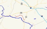
Maryland Route 464 is a state highway
in the U.S. state of Maryland
. Known for most of its length as Point of Rocks Road, the state highway runs 8.1 miles (13 km) from MD 17
and MD 79
in Rosemont
east to Ballenger Creek Pike in Point of Rocks
. MD 464 connects Brunswick
with U.S. Route 15
in Point of Rocks in southern Frederick County
. The state highway was constructed from Brunswick starting in the early 1930s. The highway was constructed west from Point of Rocks in the late 1930s; the gap in the middle was filled in the early 1940s. In 1950, MD 464 was extended west through Brunswick to Knoxville
. MD 464 was placed on its present course between Brunswick and Rosemont in 1968.
, the state highway turns northeast onto Point of Rocks Road. MD 464 crosses Little Catoctin Creek and Catoctin Creek
, then starts heading southeast, paralleling Catoctin Creek until shortly before its intersection with Lander Road. The state highway meets the southern end of Lander Road prior to crossing Catoctin Mountain
. MD 464 descends the mountain and meets US 15 (Catoctin Mountain Highway) at a roundabout
on the edge of Point of Rocks. The state highway continues east a short distance to its eastern terminus at Ballenger Creek Pike next to St. Paul's Episcopal Church.
MD 464 was extended into Brunswick in 1950. The state highway followed Ninth Avenue to Potomac Street, then Potomac Street to the western limit of Brunswick. There, MD 464 continued west along Knoxville Road, assuming all of what was then MD 70 to US 340
(now MD 180
) in Knoxville. In 1968, MD 464 was removed from downtown Brunswick and routed west from Ninth Avenue along Souder Road to the intersection of MD 17 and MD 79 in Rosemont. Knoxville Road was designated MD 478
by 1971. MD 464's roundabout at US 15 was constructed in 2009. The state highway's bridge over Catoctin Creek was replaced in 2010 and 2011. MD 464 was closed to through traffic between Olive School Road and Lander Road when the old bridge was dismantled starting in June 2010. MD 464 reopened when the new bridge was completed in February 2011.
.
{| class=wikitable
!Location
!Mile
!Road
!Notes
|-
|Rosemont
|0.00
|
|Western terminus
|-
|Brunswick
|1.03
|Ninth Avenue south / Cummings Drive east
|MD 464 turns from Souder Road north onto Point of Rocks Road
|-
|rowspan=2|Point of Rocks
|7.98
|
|Roundabout
|-
|8.10
|Ballenger Creek Pike
|Eastern terminus
State highway
State highway, state road or state route can refer to one of three related concepts, two of them related to a state or provincial government in a country that is divided into states or provinces :#A...
in the U.S. state of Maryland
Maryland
Maryland is a U.S. state located in the Mid Atlantic region of the United States, bordering Virginia, West Virginia, and the District of Columbia to its south and west; Pennsylvania to its north; and Delaware to its east...
. Known for most of its length as Point of Rocks Road, the state highway runs 8.1 miles (13 km) from MD 17
Maryland Route 17
Maryland Route 17 is a state highway in the U.S. state of Maryland. The state highway begins at the Virginia state line at the Potomac River in Brunswick, where the highway continues south as Virginia State Route 287 . MD 17 runs north from the Brunswick Bridge to the Frederick–Washington...
and MD 79
Maryland Route 79
Maryland Route 79 is a state highway in the U.S. state of Maryland. Known as Petersville Road, the state highway runs from MD 17 and MD 464 in Rosemont north to MD 180 in Petersville. MD 79 and the adjacent portion of MD 17 south to Brunswick were constructed in 1916...
in Rosemont
Rosemont, Maryland
Rosemont is a village in Frederick County, Maryland, United States. The population was 273 at the 2000 census.-Geography:Rosemont is located at ....
east to Ballenger Creek Pike in Point of Rocks
Point of Rocks, Maryland
Point of Rocks is a community in Frederick County, Maryland. It is named for the striking rock formation on the adjacent Catoctin Mountain, which were formed by the Potomac River cutting through the ridge in a water gap, a typical formation in the Ridge-and-Valley Appalachians...
. MD 464 connects Brunswick
Brunswick, Maryland
Brunswick is a city in Frederick County, Maryland, United States. The population was 5,870 at the 2010 census.- History :The area now known as Brunswick was originally home to the Susquehanna Indians. In 1728 the first settlement was built, and the region became known as Eel Town, because the...
with U.S. Route 15
U.S. Route 15 in Maryland
U.S. Route 15 is a part of the U.S. Highway System that runs from Walterboro, South Carolina to Painted Post, New York. In Maryland, the highway runs from the Virginia state line at the Potomac River in Point of Rocks north to the Pennsylvania state line near Emmitsburg. US 15 is...
in Point of Rocks in southern Frederick County
Frederick County, Maryland
Frederick County is a county located in the western part of the U.S. state of Maryland, bordering the southern border of Pennsylvania and the northeastern border of Virginia. As of the 2010 Census, the population was 233,385....
. The state highway was constructed from Brunswick starting in the early 1930s. The highway was constructed west from Point of Rocks in the late 1930s; the gap in the middle was filled in the early 1940s. In 1950, MD 464 was extended west through Brunswick to Knoxville
Knoxville, Maryland
Knoxville is an unincorporated community in Washington County, Maryland, United States.-References:...
. MD 464 was placed on its present course between Brunswick and Rosemont in 1968.
Route description
MD 464 begins at an intersection with MD 17 and MD 79 (Petersville Road) just north of the boundary between the town of Brunswick and the village of Rosemont. MD 17 heads west as Burkittsville Road and south as Petersville Road into Brunswick. MD 464 heads southeast as two-lane Souder Road between residential subdivisions and farmland and enters the town of Brunswick. At its intersection with Ninth Avenue and Cummings Drive in front of Brunswick High SchoolBrunswick High School (Maryland)
Brunswick High School is a four-year public high school in Brunswick, Frederick County, Maryland, United States.-Overview:The school is near the Virginia border near the Potomac River, just off of Maryland Route 464, and a couple miles southeast of U.S. Route 340.The current building was...
, the state highway turns northeast onto Point of Rocks Road. MD 464 crosses Little Catoctin Creek and Catoctin Creek
Catoctin Creek (Maryland)
Catoctin Creek is a tributary of the Potomac River in Frederick County, Maryland, USA. Its source is formed in the Myersville, MD area and flows directly south for the entire length of the stream. Catoctin Creek enters the Potomac River east of Brunswick. The stream flows through Catoctin Creek...
, then starts heading southeast, paralleling Catoctin Creek until shortly before its intersection with Lander Road. The state highway meets the southern end of Lander Road prior to crossing Catoctin Mountain
Catoctin Mountain
Catoctin Mountain, along with the geologically associated Bull Run Mountains, comprises the easternmost mountain ridge of the Blue Ridge Mountains, which are in turn a part of the Appalachian Mountains range...
. MD 464 descends the mountain and meets US 15 (Catoctin Mountain Highway) at a roundabout
Roundabout
A roundabout is the name for a road junction in which traffic moves in one direction around a central island. The word dates from the early 20th century. Roundabouts are common in many countries around the world...
on the edge of Point of Rocks. The state highway continues east a short distance to its eastern terminus at Ballenger Creek Pike next to St. Paul's Episcopal Church.
History
MD 464 was constructed east from the intersection of Souder Road and Ninth Avenue to Olive School Road starting shortly after 1930 and completed in 1933; this section included a new concrete T-beam bridge over Little Catoctin Creek. The state highway was extended east to Lander Road, including a new through truss bridge over Catoctin Creek, between 1933 and 1935. One mile (1.6 km) of highway was constructed from Ballenger Creek Pike toward the southern end of Lander Road in 1938. The gap in MD 464 was filled in 1941. In 1944, the Maryland State Roads Commission suggested extending the state highway east to US 15 (now MD 28); this proposal has yet to pass.MD 464 was extended into Brunswick in 1950. The state highway followed Ninth Avenue to Potomac Street, then Potomac Street to the western limit of Brunswick. There, MD 464 continued west along Knoxville Road, assuming all of what was then MD 70 to US 340
U.S. Route 340 in Maryland
U.S. Route 340 is a part of the U.S. Highway System that runs from Greenville, Virginia to Frederick, Maryland. In Maryland, the U.S. highway runs from the Virginia state line at the Potomac River at Sandy Hook east to its northern terminus at US 15 and US 40 in Frederick...
(now MD 180
Maryland Route 180
Maryland Route 180 is a state highway in the U.S. state of Maryland. Known for most of its length as Jefferson Pike, the state highway runs from U.S. Route 340 in Knoxville east to MD 351 and Interstate 70 in Frederick. MD 180 is the old alignment of US 340 through Knoxville, Petersville, and...
) in Knoxville. In 1968, MD 464 was removed from downtown Brunswick and routed west from Ninth Avenue along Souder Road to the intersection of MD 17 and MD 79 in Rosemont. Knoxville Road was designated MD 478
Maryland Route 478
Maryland Route 478 is a state highway in the U.S. state of Maryland. Known as Knoxville Road, the state highway runs from MD 180 in Knoxville east to Florida Avenue in Brunswick. MD 478 was constructed as MD 70 in the late 1920s. In 1950, MD 70 was replaced with an extended MD 464...
by 1971. MD 464's roundabout at US 15 was constructed in 2009. The state highway's bridge over Catoctin Creek was replaced in 2010 and 2011. MD 464 was closed to through traffic between Olive School Road and Lander Road when the old bridge was dismantled starting in June 2010. MD 464 reopened when the new bridge was completed in February 2011.
Junction list
The entire route is in Frederick CountyFrederick County, Maryland
Frederick County is a county located in the western part of the U.S. state of Maryland, bordering the southern border of Pennsylvania and the northeastern border of Virginia. As of the 2010 Census, the population was 233,385....
.
{| class=wikitable
!Location
!Mile
!Road
!Notes
|-
|Rosemont
Rosemont, Maryland
Rosemont is a village in Frederick County, Maryland, United States. The population was 273 at the 2000 census.-Geography:Rosemont is located at ....
|0.00
|
|Western terminus
|-
|Brunswick
Brunswick, Maryland
Brunswick is a city in Frederick County, Maryland, United States. The population was 5,870 at the 2010 census.- History :The area now known as Brunswick was originally home to the Susquehanna Indians. In 1728 the first settlement was built, and the region became known as Eel Town, because the...
|1.03
|Ninth Avenue south / Cummings Drive east
|MD 464 turns from Souder Road north onto Point of Rocks Road
|-
|rowspan=2|Point of Rocks
Point of Rocks, Maryland
Point of Rocks is a community in Frederick County, Maryland. It is named for the striking rock formation on the adjacent Catoctin Mountain, which were formed by the Potomac River cutting through the ridge in a water gap, a typical formation in the Ridge-and-Valley Appalachians...
|7.98
|
|Roundabout
Roundabout
A roundabout is the name for a road junction in which traffic moves in one direction around a central island. The word dates from the early 20th century. Roundabouts are common in many countries around the world...
|-
|8.10
|Ballenger Creek Pike
|Eastern terminus