

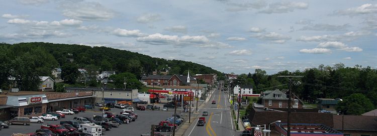
Hancock, Maryland
Encyclopedia
Hancock is a town in Washington County
, Maryland
, United States
. The population was 1,725 at the 2000 census. The Western Maryland
community is notable for being located at the narrowest part of the state. The north-south distance from the Pennsylvania state line to the West Virginia state line is only 1.8 miles (2.9 km) at Hancock.
 Hancock is located at 39°42′7"N 78°10′51"W.
According to the United States Census Bureau
, the town has a total area of 2.7 square miles (7 km²), of which 2.7 square miles (7 km²) is land and 0.04 square mile (0.1035995244 km²) (0.74%) is water.
The state of Maryland narrows to a width of less than two miles in the Hancock area—the smallest non-vertex
border-to-border distance of any U.S. state. It is at the junction of Interstates 68 and 70.
The Chesapeake & Ohio Canal passes through the town, and the Western Maryland Rail Trail
connects Hancock with Fort Frederick State Park
.
of 2000, there were 1,725 people, 735 households, and 462 families residing in the town. The population density
was 637.8 people per square mile (246.7/km²). There were 803 housing units at an average density of 296.9 per square mile (114.8/km²). The racial makeup of the town was 98.26% White, 0.35% African American, 0.35% Native American, 0.06% Asian, 0.12% Pacific Islander, 0.12% from other races
, and 0.75% from two or more races. Hispanic or Latino of any race were 0.46% of the population.
There were 735 households out of which 27.6% had children under the age of 18 living with them, 41.8% were married couples
living together, 16.3% had a female householder with no husband present, and 37.1% were non-families. 31.2% of all households were made up of individuals and 15.8% had someone living alone who was 65 years of age or older. The average household size was 2.30 and the average family size was 2.86.
In the town the population was spread out with 24.5% under the age of 18, 9.5% from 18 to 24, 28.2% from 25 to 44, 21.9% from 45 to 64, and 15.8% who were 65 years of age or older. The median age was 36 years. For every 100 females there were 88.3 males. For every 100 females age 18 and over, there were 80.8 males.
The median income for a household in the town was $28,750, and the median income for a family was $32,538. Males had a median income of $25,353 versus $20,304 for females. The per capita income
for the town was $13,758. About 11.6% of families and 16.8% of the population were below the poverty line, including 19.7% of those under age 18 and 13.7% of those age 65 or over.
Washington County, Maryland
Washington County is a county located in the western part of the U.S. state of Maryland, bordering southern Pennsylvania to the north, northern Virginia to the south, and the Eastern Panhandle of West Virginia to the south and west. As of the 2010 Census, its population is 147,430...
, Maryland
Maryland
Maryland is a U.S. state located in the Mid Atlantic region of the United States, bordering Virginia, West Virginia, and the District of Columbia to its south and west; Pennsylvania to its north; and Delaware to its east...
, United States
United States
The United States of America is a federal constitutional republic comprising fifty states and a federal district...
. The population was 1,725 at the 2000 census. The Western Maryland
Western Maryland
Western Maryland is the portion of the U.S. state of Maryland that consists of Frederick, Washington, Allegany, and Garrett counties. The region is bounded by the Mason-Dixon line to the north, Preston County, West Virginia to the west, and the Potomac River to the south. There is dispute over the...
community is notable for being located at the narrowest part of the state. The north-south distance from the Pennsylvania state line to the West Virginia state line is only 1.8 miles (2.9 km) at Hancock.
Geography
According to the United States Census Bureau
United States Census Bureau
The United States Census Bureau is the government agency that is responsible for the United States Census. It also gathers other national demographic and economic data...
, the town has a total area of 2.7 square miles (7 km²), of which 2.7 square miles (7 km²) is land and 0.04 square mile (0.1035995244 km²) (0.74%) is water.
The state of Maryland narrows to a width of less than two miles in the Hancock area—the smallest non-vertex
Vertex (geometry)
In geometry, a vertex is a special kind of point that describes the corners or intersections of geometric shapes.-Of an angle:...
border-to-border distance of any U.S. state. It is at the junction of Interstates 68 and 70.
The Chesapeake & Ohio Canal passes through the town, and the Western Maryland Rail Trail
Western Maryland Rail Trail
The Western Maryland Rail Trail is a long shared-use asphalt-paved rail trail from Fort Frederick to Pearre Station, Maryland, United States, that is suitable for walkers, joggers, bikers, rollerbladers and, weather permitting, cross country skiing....
connects Hancock with Fort Frederick State Park
Fort Frederick State Park
Fort Frederick State Park is a Maryland state park surrounding the restored Fort Frederick, a fort from the French and Indian War and American Revolutionary War. The park is south of the town of Big Pool on the Potomac River; the Chesapeake and Ohio Canal runs through the park grounds...
.
Demographics
As of the censusCensus
A census is the procedure of systematically acquiring and recording information about the members of a given population. It is a regularly occurring and official count of a particular population. The term is used mostly in connection with national population and housing censuses; other common...
of 2000, there were 1,725 people, 735 households, and 462 families residing in the town. The population density
Population density
Population density is a measurement of population per unit area or unit volume. It is frequently applied to living organisms, and particularly to humans...
was 637.8 people per square mile (246.7/km²). There were 803 housing units at an average density of 296.9 per square mile (114.8/km²). The racial makeup of the town was 98.26% White, 0.35% African American, 0.35% Native American, 0.06% Asian, 0.12% Pacific Islander, 0.12% from other races
Race (United States Census)
Race and ethnicity in the United States Census, as defined by the Federal Office of Management and Budget and the United States Census Bureau, are self-identification data items in which residents choose the race or races with which they most closely identify, and indicate whether or not they are...
, and 0.75% from two or more races. Hispanic or Latino of any race were 0.46% of the population.
There were 735 households out of which 27.6% had children under the age of 18 living with them, 41.8% were married couples
Marriage
Marriage is a social union or legal contract between people that creates kinship. It is an institution in which interpersonal relationships, usually intimate and sexual, are acknowledged in a variety of ways, depending on the culture or subculture in which it is found...
living together, 16.3% had a female householder with no husband present, and 37.1% were non-families. 31.2% of all households were made up of individuals and 15.8% had someone living alone who was 65 years of age or older. The average household size was 2.30 and the average family size was 2.86.
In the town the population was spread out with 24.5% under the age of 18, 9.5% from 18 to 24, 28.2% from 25 to 44, 21.9% from 45 to 64, and 15.8% who were 65 years of age or older. The median age was 36 years. For every 100 females there were 88.3 males. For every 100 females age 18 and over, there were 80.8 males.
The median income for a household in the town was $28,750, and the median income for a family was $32,538. Males had a median income of $25,353 versus $20,304 for females. The per capita income
Per capita income
Per capita income or income per person is a measure of mean income within an economic aggregate, such as a country or city. It is calculated by taking a measure of all sources of income in the aggregate and dividing it by the total population...
for the town was $13,758. About 11.6% of families and 16.8% of the population were below the poverty line, including 19.7% of those under age 18 and 13.7% of those age 65 or over.