

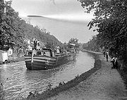
Chesapeake and Ohio Canal
Encyclopedia
.jpg)
Potomac River
The Potomac River flows into the Chesapeake Bay, located along the mid-Atlantic coast of the United States. The river is approximately long, with a drainage area of about 14,700 square miles...
in Maryland
Maryland
Maryland is a U.S. state located in the Mid Atlantic region of the United States, bordering Virginia, West Virginia, and the District of Columbia to its south and west; Pennsylvania to its north; and Delaware to its east...
from Cumberland, Maryland
Cumberland, Maryland
Cumberland is a city in the far western, Appalachian portion of Maryland, United States. It is the county seat of Allegany County, and the primary city of the Cumberland, MD-WV Metropolitan Statistical Area. At the 2010 census, the city had a population of 20,859, and the metropolitan area had a...
to Washington, D.C.
Washington, D.C.
Washington, D.C., formally the District of Columbia and commonly referred to as Washington, "the District", or simply D.C., is the capital of the United States. On July 16, 1790, the United States Congress approved the creation of a permanent national capital as permitted by the U.S. Constitution....
The total length of the canal
Canal
Canals are man-made channels for water. There are two types of canal:#Waterways: navigable transportation canals used for carrying ships and boats shipping goods and conveying people, further subdivided into two kinds:...
is about 184.5 miles (296.9 km). The elevation change of 605 ft (184 m) was accommodated with 74 canal locks
Lock (water transport)
A lock is a device for raising and lowering boats between stretches of water of different levels on river and canal waterways. The distinguishing feature of a lock is a fixed chamber in which the water level can be varied; whereas in a caisson lock, a boat lift, or on a canal inclined plane, it is...
. To enable the canal to cross relatively small streams, over 150 culvert
Culvert
A culvert is a device used to channel water. It may be used to allow water to pass underneath a road, railway, or embankment. Culverts can be made of many different materials; steel, polyvinyl chloride and concrete are the most common...
s were built. The crossing of major streams required the construction of 11 aqueduct
Aqueduct
An aqueduct is a water supply or navigable channel constructed to convey water. In modern engineering, the term is used for any system of pipes, ditches, canals, tunnels, and other structures used for this purpose....
s (10 of which remain). The canal also extends through the 3118 ft (950 m) Paw Paw Tunnel
Paw Paw Tunnel
The Paw Paw Tunnel is a long canal tunnel on the Chesapeake and Ohio Canal in Allegany County, Maryland. Located near Paw Paw, West Virginia, it was built to bypass the Paw-Paw Bends, a six-mile stretch of the Potomac River containing five horseshoe bends...
. The principal cargo was coal from the Allegheny Mountains
Allegheny Mountains
The Allegheny Mountain Range , also spelled Alleghany, Allegany and, informally, the Alleghenies, is part of the vast Appalachian Mountain Range of the eastern United States and Canada...
. The canal
Canal
Canals are man-made channels for water. There are two types of canal:#Waterways: navigable transportation canals used for carrying ships and boats shipping goods and conveying people, further subdivided into two kinds:...
way is now maintained as a park
Park
A park is a protected area, in its natural or semi-natural state, or planted, and set aside for human recreation and enjoyment, or for the protection of wildlife or natural habitats. It may consist of rocks, soil, water, flora and fauna and grass areas. Many parks are legally protected by...
, with a linear trail
Trail
A trail is a path with a rough beaten or dirt/stone surface used for travel. Trails may be for use only by walkers and in some places are the main access route to remote settlements...
following the old towpath
Towpath
A towpath is a road or trail on the bank of a river, canal, or other inland waterway. The purpose of a towpath is to allow a land vehicle, beasts of burden, or a team of human pullers to tow a boat, often a barge...
, the Chesapeake and Ohio Canal National Historical Park
Chesapeake and Ohio Canal National Historical Park
The Chesapeake and Ohio Canal National Historical Park is a United States National Historical Park located in the District of Columbia and the states of Maryland and West Virginia. The park was established as a National Monument in 1961 by President Dwight D...
.
Early river projects
After the American Revolutionary WarAmerican Revolutionary War
The American Revolutionary War , the American War of Independence, or simply the Revolutionary War, began as a war between the Kingdom of Great Britain and thirteen British colonies in North America, and ended in a global war between several European great powers.The war was the result of the...
, George Washington
George Washington
George Washington was the dominant military and political leader of the new United States of America from 1775 to 1799. He led the American victory over Great Britain in the American Revolutionary War as commander-in-chief of the Continental Army from 1775 to 1783, and presided over the writing of...
was the chief advocate of using waterways to connect the Eastern Seaboard
East Coast of the United States
The East Coast of the United States, also known as the Eastern Seaboard, refers to the easternmost coastal states in the United States, which touch the Atlantic Ocean and stretch up to Canada. The term includes the U.S...
to the Great Lakes
Great Lakes
The Great Lakes are a collection of freshwater lakes located in northeastern North America, on the Canada – United States border. Consisting of Lakes Superior, Michigan, Huron, Erie, and Ontario, they form the largest group of freshwater lakes on Earth by total surface, coming in second by volume...
and the Ohio River
Ohio River
The Ohio River is the largest tributary, by volume, of the Mississippi River. At the confluence, the Ohio is even bigger than the Mississippi and, thus, is hydrologically the main stream of the whole river system, including the Allegheny River further upstream...
. Washington founded the Potowmack Company
Potomac Company
The Potomac Company was created in 1785 to make improvements to the Potomac River in order to improve its navigability. The Potomac Company built five skirting canals around the major falls...
in 1785 to make navigability improvements to the Potomac River. The Patowmack Company built a number of skirting canals around the major falls including the Patowmack Canal
Patowmack Canal
The Patowmack Canal is an inoperative canal located in Virginia, United States, that was designed to bypass rapids in the Potomac River upstream of the present Washington, D.C. area...
in Virginia
Virginia
The Commonwealth of Virginia , is a U.S. state on the Atlantic Coast of the Southern United States. Virginia is nicknamed the "Old Dominion" and sometimes the "Mother of Presidents" after the eight U.S. presidents born there...
. When completed, it allowed boats and rafts to float downstream towards Georgetown. Going upstream was a bit harder. Slim boats could be slowly poled upriver. The completion of the Erie Canal
Erie Canal
The Erie Canal is a waterway in New York that runs about from Albany, New York, on the Hudson River to Buffalo, New York, at Lake Erie, completing a navigable water route from the Atlantic Ocean to the Great Lakes. The canal contains 36 locks and encompasses a total elevation differential of...
worried southern traders that their business might be threatened by the northern canal; plans for a canal linking the Ohio and Chesapeake were drawn up as early as 1820.
Building the canal
Benjamin Wright
Benjamin Wright was an American civil engineer who served as Chief Engineer of both the Erie Canal and Chesapeake and Ohio Canal. In 1969 he was declared the "Father of American Civil Engineering" by the American Society of Civil Engineers.Wright was born in Wethersfield, Connecticut to Ebenezer...
, formerly Chief Engineer of the Erie Canal, was named Chief Engineer of this new effort, and construction began with a groundbreaking ceremony on July 4, 1828 by President
President of the United States
The President of the United States of America is the head of state and head of government of the United States. The president leads the executive branch of the federal government and is the commander-in-chief of the United States Armed Forces....
John Quincy Adams
John Quincy Adams
John Quincy Adams was the sixth President of the United States . He served as an American diplomat, Senator, and Congressional representative. He was a member of the Federalist, Democratic-Republican, National Republican, and later Anti-Masonic and Whig parties. Adams was the son of former...
.
The narrow strip of available land along the Potomac River from Point of Rocks
Point of Rocks, Maryland
Point of Rocks is a community in Frederick County, Maryland. It is named for the striking rock formation on the adjacent Catoctin Mountain, which were formed by the Potomac River cutting through the ridge in a water gap, a typical formation in the Ridge-and-Valley Appalachians...
to Harpers Ferry
Harpers Ferry, West Virginia
Harpers Ferry is a historic town in Jefferson County, West Virginia, United States. In many books the town is called "Harper's Ferry" with an apostrophe....
caused a legal battle between the C&O Canal and the Baltimore and Ohio Railroad
Baltimore and Ohio Railroad
The Baltimore and Ohio Railroad was one of the oldest railroads in the United States and the first common carrier railroad. It came into being mostly because the city of Baltimore wanted to compete with the newly constructed Erie Canal and another canal being proposed by Pennsylvania, which...
(B&O) in 1828 as both sought to exclude the other from its use. Following a Maryland state court battle involving Daniel Webster
Daniel Webster
Daniel Webster was a leading American statesman and senator from Massachusetts during the period leading up to the Civil War. He first rose to regional prominence through his defense of New England shipping interests...
and Roger B. Taney
Roger B. Taney
Roger Brooke Taney was the fifth Chief Justice of the United States, holding that office from 1836 until his death in 1864. He was the first Roman Catholic to hold that office or sit on the Supreme Court of the United States. He was also the eleventh United States Attorney General. He is most...
, the companies later compromised to allow the sharing of the right of way.
The canal initially connected to the Potomac River on the east side of Georgetown by joining Rock Creek
Rock Creek (Potomac River)
Rock Creek is a free-flowing tributary of the Potomac River, which empties into the Atlantic Ocean via the Chesapeake Bay. The creek is long, with a drainage area of about...
east of Lock 1, 0.3 mile (0.482802 km) upstream of the Tidewater Lock
Tidewater Lock
The Tidewater Lock is a dam in Washington, D.C. to the west of the mouth of Rock Creek at the Potomac River, on the east side of Georgetown. It is sometimes listed as Lock 0 on the Chesapeake and Ohio Canal....
, whose remnants still exist to the west of the mouth of the creek. In 1831 the first section opened from Georgetown to Seneca, Maryland
Seneca, Maryland
Seneca is an unincorporated community in Montgomery County, Maryland, United States.-References:...
. In 1833 the canal opened to Harpers Ferry, and at the Georgetown end it was extended 1.5 miles (2.4 km) eastward to Tiber Creek
Tiber Creek
Tiber Creek or Tyber Creek was a tributary of the Potomac River in Washington, D.C.Originally known as Goose Creek, it was renamed after Rome's Tiber River as the lands southeast of then Georgetown, Maryland, were selected for the City of Washington, the new capital of the United States...
, near the western terminus of the Washington City Canal
Washington City Canal
The Washington City Canal operated from 1815 until the mid-1850s in Washington, D.C. The canal connected the Anacostia River, called the "Eastern Branch" at that time, to Tiber Creek, the Potomac River, and later the Chesapeake and Ohio Canal...
. A lock keeper's house at the eastern end of this "Washington Branch" of the C&O Canal remains at the southwest corner of Constitution Avenue
Constitution Avenue
In Washington, D.C., Constitution Avenue is a major east-west street running just north of the United States Capitol in the city's Northwest and Northeast quadrants...
and 17th Street, N.W., at the edge of the National Mall
National Mall
The National Mall is an open-area national park in downtown Washington, D.C., the capital of the United States. The National Mall is a unit of the National Park Service , and is administered by the National Mall and Memorial Parks unit...
in Washington, D.C.
Star routes
Star routes is a term used in connection with the United States postal service and the contracting of mail delivery services. The term is defunct as of 1970, but still is occasionally used to refer to Highway Contract Routes or which replaced the Star routes.-Background:Prior to 1845,...
for the carriage of mails from Georgetown to Shepherdstown
Shepherdstown, West Virginia
Shepherdstown is a town in Jefferson County, West Virginia, United States, located along the Potomac River. It is the oldest town in the state, having been chartered in 1762 by Colonial Virginia's General Assembly. Since 1863, Shepherdstown has been in West Virginia, and is the oldest town in...
using canal packets. The contract was held by Albert Humrickhouse at $1,000 per annum for a daily service of 72 book miles. The canal approached Hancock, Maryland
Hancock, Maryland
Hancock is a town in Washington County, Maryland, United States. The population was 1,725 at the 2000 census. The Western Maryland community is notable for being located at the narrowest part of the state...
by 1839. In 1843, the Potomac Aqueduct Bridge
Potomac Aqueduct Bridge
The Aqueduct Bridge was a bridge between Georgetown, Washington, D.C., and Rosslyn, Virginia, in Arlington County. It was built to transport cargo-carrying boats on the Chesapeake and Ohio Canal in Georgetown across the Potomac River to the Alexandria Canal...
was constructed near the present-day Francis Scott Key Bridge to connect the Chesapeake and Ohio Canal to the Alexandria Canal which led to Alexandria, Virginia
Alexandria, Virginia
Alexandria is an independent city in the Commonwealth of Virginia. As of 2009, the city had a total population of 139,966. Located along the Western bank of the Potomac River, Alexandria is approximately six miles south of downtown Washington, D.C.Like the rest of northern Virginia, as well as...
. By the time the canal reached Cumberland in 1850, it had already been rendered obsolete; the B&O Railroad had reached Cumberland eight years previously. Debt-ridden, the company dropped its plan to continue construction of the next 180 miles (289.7 km) of the canal into the Ohio valley.
In the 1870s, a canal inclined plane
Canal inclined plane
An inclined plane is a system used on some canals for raising boats between different water levels. Boats may be conveyed afloat, in caissons, or may be carried in cradles or slings. It can be considered as a specialised type of cable railway....
was built two miles (3 km) upriver from Georgetown, so that boats whose destination was downriver from Washington could bypass the congestion in Georgetown. The inclined plane was dismantled after a major flood in 1889 when ownership of the canal transferred to the B&O Railroad, which operated the canal to prevent its right of way (particularly at Point of Rocks) from falling into the hands of the Western Maryland Railway
Western Maryland Railway
The Western Maryland Railway was an American Class I railroad which operated in Maryland, West Virginia, and Pennsylvania. It was primarily a coal hauling and freight railroad, with a small passenger train operation. The WM became part of the Chessie System in 1973 and ceased operating its lines...
. Operations ceased in 1924 after another flood damaged the canal.
The planned C&O Canal route to navigable waters of the Mississippi watershed would have followed the North Branch Potomac River west from Cumberland to the Savage River
Savage River (Maryland)
The Savage River is a river in Garrett County, Maryland, and is the first major tributary of the North Branch Potomac River from its source. The river was named for 18th century surveyor John Savage....
. Via the Savage, the canal would have crossed the Eastern Continental Divide
Eastern Continental Divide
The Eastern Continental Divide, in conjunction with other continental divides of North America, demarcates two watersheds of the Atlantic Ocean: the Gulf of Mexico watershed and the Atlantic Seaboard watershed. Prior to 1760, the divide represented the boundary between British and French colonial...
at the gap between the Savage
Savage Mountain
The two Big Savage Mountain summits are part of Savage Mountain.The two Big Savage Mountain summits are part of Savage Mountain....
and Backbone Mountain
Backbone Mountain
Backbone Mountain is a ridge of the Allegheny Mountains of the central Appalachian Mountain Range. It is situated in the U.S. states of West Virginia and Maryland and forms a portion of the Eastern Continental Divide...
s near where present day
Present day
The term "present day" is used to describe the approximate period of time that surrounds the present. Depending on the context, this period may be as narrow as referring to the immediate moment, or as broad as referring to the current year or decade...
O'Brien Road intersects Maryland Route 495
Maryland Route 495
Maryland Route 495 is a state highway in the U.S. state of Maryland. Known for most of its length as Bittinger Road, the state highway runs from MD 135 in Altamont north to U.S. Route 40 Alternate in Grantsville. MD 495 passes through rural areas of central Garrett County, connecting Bittinger...
, then via the valley of present day Deep Creek Lake
Deep Creek Lake
Deep Creek Lake is the largest inland body of water in the state of Maryland. It covers approximately and has of shoreline. Like all lakes in Maryland, it is man-made. The lake is home to a wide variety of freshwater fish and aquatic birds. The Wisp ski resort is located nearby...
, followed the Youghiogheny River
Youghiogheny River
The Youghiogheny River , or the Yough for short, is a tributary of the Monongahela River in the U.S. states of West Virginia, Maryland, and Pennsylvania...
to navigable waters.
National park
In 1938 the abandoned canal was obtained from the B&O by the United States in exchange for a loan from the federal Reconstruction Finance CorporationReconstruction Finance Corporation
The Reconstruction Finance Corporation was an independent agency of the United States government, established and chartered by the US Congress in 1932, Act of January 22, 1932, c. 8, 47 Stat. 5, during the administration of President Herbert Hoover. It was modeled after the War Finance Corporation...
. The government planned to restore it as a recreation area. Although the lower 22 miles (35 km) of the canal were repaired and rewatered, the project was halted when the United States entered World War II
World War II
World War II, or the Second World War , was a global conflict lasting from 1939 to 1945, involving most of the world's nations—including all of the great powers—eventually forming two opposing military alliances: the Allies and the Axis...
and resources were needed elsewhere. After the war, Congress
United States Congress
The United States Congress is the bicameral legislature of the federal government of the United States, consisting of the Senate and the House of Representatives. The Congress meets in the United States Capitol in Washington, D.C....
expressed interest in developing the canal and towpath as a parkway
Parkway
The term parkway has several distinct principal meanings and numerous synonyms around the world, for either a type of landscaped area or a type of road.Type of landscaped area:...
. However, the idea of turning the canal over to automobiles was opposed by some, including United States Supreme Court Associate Justice
Associate Justice
Associate Justice or Associate Judge is the title for a member of a judicial panel who is not the Chief Justice in some jurisdictions. The title "Associate Justice" is used for members of the United States Supreme Court and some state supreme courts, and for some other courts in Commonwealth...
William O. Douglas
William O. Douglas
William Orville Douglas was an Associate Justice of the United States Supreme Court. With a term lasting 36 years and 209 days, he is the longest-serving justice in the history of the Supreme Court...
. In March 1954, Douglas led an eight-day hike of the towpath from Cumberland to D.C. Although 58 people participated in one part of the hike or another, only nine men, including Douglas, hiked the full 184.5 miles (297 km). Popular response to and press coverage of the hike turned the tide against the parkway idea and, on January 8, 1971, the canal was designated a National Historical Park.
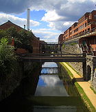
Presently the park includes nearly 20,000 acres (80 km²) and receives over 3 million recorded visits each year. Flooding continues to threaten historical structures on the canal and attempts at restoration. The Park Service has re-watered portions of the canal, but the majority of the canal does not have water in it.
Today the park is a popular getaway for Washington residents. The towpath is popular with bikers and joggers. Fishing and boating are popular in the re-watered portions, and whitewater kayakers tackling the world class rapids of the Potomac sometimes use the canal to shuttle upstream. The park offers rides on two reproduction canal boats, the Georgetown and the Charles F. Mercer, during the spring, summer and autumn. The boats are pulled by mule
Mule
A mule is the offspring of a male donkey and a female horse. Horses and donkeys are different species, with different numbers of chromosomes. Of the two F1 hybrids between these two species, a mule is easier to obtain than a hinny...
s and park rangers in historical dress work the locks and boat while presenting a historical program.
Locks and engineering
To build the canal, the C&O Canal Company utilized a total of 74 lift locksLocks on the C&O Canal
The Locks on the C&O Canal, located in Maryland, West Virginia, and Washington, D.C. of the United States, were numbered from 1 to 75 with two locks, 63⅓ and 64⅔, having fractional numbers and no lock 65...
that raised the canal from sea level
Sea level
Mean sea level is a measure of the average height of the ocean's surface ; used as a standard in reckoning land elevation...
at Georgetown to 610 feet (185.9 m) at Cumberland. Eleven stone aqueducts were built to carry the canal over the Potomac's tributaries. In addition, seven dams were built to supply water to the canal, waste weir
Weir
A weir is a small overflow dam used to alter the flow characteristics of a river or stream. In most cases weirs take the form of a barrier across the river that causes water to pool behind the structure , but allows water to flow over the top...
s to control water flow, and 200 culverts to carry roads and streams underneath the canal. An assortment of lockhouses, bridges, and stop gates were also constructed along the canal's path.
One of the most impressive engineering features of the canal is the Paw Paw Tunnel
Paw Paw Tunnel
The Paw Paw Tunnel is a long canal tunnel on the Chesapeake and Ohio Canal in Allegany County, Maryland. Located near Paw Paw, West Virginia, it was built to bypass the Paw-Paw Bends, a six-mile stretch of the Potomac River containing five horseshoe bends...
, which runs for 3118 feet (950.4 m) under a mountain. Built to save six miles (10 km) of construction around the obstacle, the 3/4-mile tunnel used over six million bricks. The tunnel took almost twelve years to build; in the end, the tunnel was only wide enough for single lane traffic.
Points of interest
- East of Mile 000: Lock Keeper's House at eastern end of Washington Branch of C&O Canal.38°52′13.6482"N 77°0′55.6878"W
- Mile 000: Tidewater Lock
- Mile 000: Rock Creek ParkRock Creek ParkRock Creek Park is a large urban natural area with public park facilities that bisects Washington, D.C. The park is administered by the National Park Service.-Rock Creek Park:The main section of the park contains , or , along the Rock Creek Valley...
38°57′10"N 77°2′30"W - Mile 000: C&O Canal Monument
- Mile 000: Lock 138°54′13.5504"N 77°3′25.9272"W
- Mile 000: Georgetown, Washington, D.C.Georgetown, Washington, D.C.Georgetown is a neighborhood located in northwest Washington, D.C., situated along the Potomac River. Founded in 1751, the port of Georgetown predated the establishment of the federal district and the City of Washington by 40 years...
38°53′59"N 77°3′27.5"W and Georgetown Visitor Center
38°54′14.5"N 77°3′31"W
- Mile 000: Potomac Heritage TrailPotomac Heritage TrailThe ', also known as the Potomac Heritage National Scenic Trail or the PHT, is a designated National Scenic Trail corridor in the northeastern United States that will connect various trails and historic sites in the states of Virginia, Maryland, and Pennsylvania, and the District of Columbia...
- on Virginia side of river. (Bikes can use it below Francis Scott Key BridgeFrancis Scott Key BridgeFrancis Scott Key Bridge, or Key Bridge can refer to:*Francis Scott Key Bridge , a bridge crossing the outer harbor of Baltimore, Maryland...
.) - Mile 001: Abutment and former canal bed of Potomac Aqueduct Bridge
- Mile 001: Capital Crescent TrailCapital Crescent TrailThe Capital Crescent Trail is an long, shared-use rail trail that runs from Georgetown in Washington, D.C., to Silver Spring, Maryland. The portion from Bethesda to Silver Spring is also called the Georgetown Branch Trail but is recognized as the Future Capital Crescent Trail.The Capital Crescent...
- Mile 002: Inclined Plane
- Mile 007: Glen Echo Park (Maryland)Glen Echo Park (Maryland)Glen Echo Park, also known as Glen Echo Amusement Park and Glen Echo Park Historic District, is a public park and national historic district in Glen Echo, Montgomery County, Maryland. It is managed by the National Park Service as part of the George Washington Memorial Parkway. It began in 1891 as...
and Lock 7 38°57′52"N 77°8′20"W - Mile 014: Billy Goat TrailBilly Goat TrailThe Billy Goat Trail is a hiking trail that follows a path between the C&O Canal and the Potomac River within the Chesapeake and Ohio Canal National Historical Park near Great Falls in Montgomery County, Maryland...
at Great Falls, Great Falls Tavern 39°0′1"N 77°14′54"W - Mile 016: Swain's Lock at Lock 21, Potomac, Md
- Mile 020: Pennyfield Lock 39°3′13.6"N 77°17′20"W
- Mile 022: Violette’s Lock (Lock 23) The canal has water in it from here south. 39°4′1"N 77°19′43"W
- Mile 022: Riley's Lock/Seneca Creek AqueductSeneca Creek (Potomac River)Seneca Creek is a stream in Montgomery County, Maryland, roughly northwest of Washington, D.C. It drains to the Potomac River.-Course:The creek begins with two main tributaries:...
39°4′7.5"N 77°20′27"W - Mile 026: Dierssen Wildlife Management AreaDierssen Wildlife Management AreaDierssen Wildlife Management Area is a Wildlife Management Area in Montgomery County, Maryland.-External links:*...
& McKee-Beshers Wildlife Management AreaMcKee-Beshers Wildlife Management AreaMcKee-Beshers Wildlife Management Area is a Wildlife Management Area in Montgomery County, Maryland. Acres of sunflowers are planted each year at McKee-Beshers WMA to attract game birds. Every July, these spectacular fields in full bloom also draw photographers, garden enthusiasts, and... - Mile 035: Poolesville, MarylandPoolesville, MarylandPoolesville is a town in Montgomery County, Maryland United States with a population of approximately 5000 people. It is surrounded by the Montgomery County Agricultural Reserve, and is considered a distant bedroom community for commuters to Washington, DC.The name of the town comes from the...
- Mile 035: White's FerryWhite's FerryWhite's Ferry is a cable ferry service operating across the Potomac River. It is located six miles west of Poolesville, Maryland, and north of Leesburg, Virginia. It is the only ferry still operating on the Potomac River. The General Jubal A...
39°9′17"N 77°31′2"W - Mile 042: Monocacy AqueductMonocacy AqueductThe Monocacy Aqueduct — or C&O Canal Aqueduct No. 2 — is the largest aqueduct on the Chesapeake and Ohio Canal, crossing the Monocacy River just before it empties into the Potomac River in Frederick County, Maryland, USA...
39°13′25"N 77°27′7"W - Mile 048: Point of Rocks, MarylandPoint of Rocks, MarylandPoint of Rocks is a community in Frederick County, Maryland. It is named for the striking rock formation on the adjacent Catoctin Mountain, which were formed by the Potomac River cutting through the ridge in a water gap, a typical formation in the Ridge-and-Valley Appalachians...
39°16′25"N 77°32′30"W - Mile 055: Brunswick, MarylandBrunswick, MarylandBrunswick is a city in Frederick County, Maryland, United States. The population was 5,870 at the 2010 census.- History :The area now known as Brunswick was originally home to the Susquehanna Indians. In 1728 the first settlement was built, and the region became known as Eel Town, because the...
39°18′41"N 77°37′50"W - Mile 058: Appalachian TrailAppalachian TrailThe Appalachian National Scenic Trail, generally known as the Appalachian Trail or simply the AT, is a marked hiking trail in the eastern United States extending between Springer Mountain in Georgia and Mount Katahdin in Maine. It is approximately long...
- Mile 060: Harpers Ferry, West VirginiaHarpers Ferry, West VirginiaHarpers Ferry is a historic town in Jefferson County, West Virginia, United States. In many books the town is called "Harper's Ferry" with an apostrophe....
39°19′31"N 77°44′36"W - Mile 073: Ferry Hill, Maryland
- Mile 073: Shepherdstown, West VirginiaShepherdstown, West VirginiaShepherdstown is a town in Jefferson County, West Virginia, United States, located along the Potomac River. It is the oldest town in the state, having been chartered in 1762 by Colonial Virginia's General Assembly. Since 1863, Shepherdstown has been in West Virginia, and is the oldest town in...
39°25′55"N 77°48′22"W - Mile 073: Sharpsburg, MarylandSharpsburg, MarylandSharpsburg is a town in Washington County, Maryland, United States, approximately south of Hagerstown. The population was 691 at the 2000 census....
39°27′28"N 77°44′58"W - Mile 099: Williamsport, MarylandWilliamsport, MarylandWilliamsport is a town in Washington County, Maryland, United States. The population was 1,868 at the 2000 census and 2,278 as of July 2008.-Geography: Williamsport is located at ....
39°35′55"N 77°49′6"W - Mile 107: Dam No. 5Power Plant and Dam No. 5 (Potomac River)Power Plant and Dam No. 5, also known as Honeywood Dam, comprises a dam on the Potomac River, originally built for the Chesapeake and Ohio Canal, and a power plant built to take advantage of the river's flow to generate hydroelectric power...
39°36′22"N 77°55′23"W - Mile 110: Four LocksFour LocksFour Locks is a former small community which is now part of the Chesapeake and Ohio Canal National Historical Park. It was once a thriving community of homes and businesses in Washington County, Maryland that supported the Chesapeake and Ohio Canal from the mid-19th century, until its closure in...
- Once a thriving community of homes and businesses supporting the canal. - Mile 110.4: McCoy's Ferry - Campground and historic American Civil WarAmerican Civil WarThe American Civil War was a civil war fought in the United States of America. In response to the election of Abraham Lincoln as President of the United States, 11 southern slave states declared their secession from the United States and formed the Confederate States of America ; the other 25...
crossing - Mile 112: Fort Frederick State ParkFort Frederick State ParkFort Frederick State Park is a Maryland state park surrounding the restored Fort Frederick, a fort from the French and Indian War and American Revolutionary War. The park is south of the town of Big Pool on the Potomac River; the Chesapeake and Ohio Canal runs through the park grounds...
; Western Maryland Rail TrailWestern Maryland Rail TrailThe Western Maryland Rail Trail is a long shared-use asphalt-paved rail trail from Fort Frederick to Pearre Station, Maryland, United States, that is suitable for walkers, joggers, bikers, rollerbladers and, weather permitting, cross country skiing....
begins - Mile 124: Hancock, MarylandHancock, MarylandHancock is a town in Washington County, Maryland, United States. The population was 1,725 at the 2000 census. The Western Maryland community is notable for being located at the narrowest part of the state...
- Mile 124: Rt. 522 Bridge to Berkeley Springs, West VirginiaBath (Berkeley Springs), West VirginiaBath is a town in the Eastern Panhandle of West Virginia, United States. It is the county seat of Morgan County. The town is incorporated as Bath, but it is often referred to by the name of its post office, Berkeley Springs. The population of the town was 663 according to the 2000 United States...
; Western Maryland Rail TrailWestern Maryland Rail TrailThe Western Maryland Rail Trail is a long shared-use asphalt-paved rail trail from Fort Frederick to Pearre Station, Maryland, United States, that is suitable for walkers, joggers, bikers, rollerbladers and, weather permitting, cross country skiing....
diverges - Mile 140: Little Orleans, MarylandLittle Orleans, MarylandLittle Orleans is an unincorporated community in Allegany County, Maryland. Little Orleans is located on the Potomac River at the mouth of Fifteenmile Creek across from Orleans Cross Roads, West Virginia. Little Orleans was served by the Chesapeake & Ohio Canal, and by the Western Maryland...
- Mile 151: Paw Paw TunnelPaw Paw TunnelThe Paw Paw Tunnel is a long canal tunnel on the Chesapeake and Ohio Canal in Allegany County, Maryland. Located near Paw Paw, West Virginia, it was built to bypass the Paw-Paw Bends, a six-mile stretch of the Potomac River containing five horseshoe bends...
- Mile 151: Paw Paw, West VirginiaPaw Paw, West VirginiaPaw Paw is a town in Morgan County, West Virginia, United States. The population was 524 at the 2000 census. The town is known for the nearby Paw Paw Tunnel. Paw Paw was incorporated by the Circuit Court of Morgan County on April 8, 1891 and named for the pawpaw, a wild fruit which formerly grew in...
- Mile 165: Oldtown, MarylandOldtown, MarylandOldtown is an unincorporated community in Allegany County, Maryland along the North Branch Potomac River founded in 18th century colonial times. The settlement was initially called "Shawanese Old Town" because it was the site of a Shawnee Amerindian village abandoned about a decade earlier...
- Mile 184: Cumberland, MarylandCumberland, MarylandCumberland is a city in the far western, Appalachian portion of Maryland, United States. It is the county seat of Allegany County, and the primary city of the Cumberland, MD-WV Metropolitan Statistical Area. At the 2010 census, the city had a population of 20,859, and the metropolitan area had a...
- Mile 184: Canal PlaceCanal PlaceCanal Place is a park owned by the State of Maryland and located in Cumberland, MD. The park includes the Western Maryland Railway Station, station plaza, a picnic area, a canal boat replica, a pedestrian bridge to George Washington’s Headquarters , picnic area, Shops at Canal Place, and the...
- Mile 184: Western Maryland Scenic RailroadWestern Maryland Scenic RailroadThe Western Maryland Scenic Railroad is a heritage railroad based in Cumberland, Maryland. It operates over ex-Western Maryland Railway trackage to Frostburg, Maryland and back using both steam and diesel locomotives....
See also
- List of canals in the United States
- Locks on the C&O CanalLocks on the C&O CanalThe Locks on the C&O Canal, located in Maryland, West Virginia, and Washington, D.C. of the United States, were numbered from 1 to 75 with two locks, 63⅓ and 64⅔, having fractional numbers and no lock 65...
- Tidewater LockTidewater LockThe Tidewater Lock is a dam in Washington, D.C. to the west of the mouth of Rock Creek at the Potomac River, on the east side of Georgetown. It is sometimes listed as Lock 0 on the Chesapeake and Ohio Canal....
- Canal Place, CumberlandCanal PlaceCanal Place is a park owned by the State of Maryland and located in Cumberland, MD. The park includes the Western Maryland Railway Station, station plaza, a picnic area, a canal boat replica, a pedestrian bridge to George Washington’s Headquarters , picnic area, Shops at Canal Place, and the...
Further reading
- Life on the Chesapeake & Ohio Canal, 1859 [York, Pa. : American Canal and Transportation Center, 1975]
- Achenbach, Joel. The Grand Idea: George Washington's Potomac and the Race to the West, Simon and Schuster, 2004.
- Blackford, John, 1771-1839. Ferry Hill Plantation journal: life on the Potomac River and the Chesapeake and Ohio Canal, 4 January 1838-15 January 1839 2d ed. Shepherdstown, W. Va. : [American Canal and Transportation Center], 1975.
- Cotton, Robert. The Chesapeake and Ohio Canal Through the Lens of Sir Robert Cotton
- Fradin, Morris. Hey-ey-ey, lock! Cabin John, Md., See-and-Know Press, 1974
- Gutheim, Frederick. The Potomac. New York: Rinehart and Co., 1949.
- Guzy, Dan. Navigation on the Upper Potomac and Its Tributaries. Western Maryland Regional Library, 2011
- Hahn, Thomas F. The Chesapeake and Ohio Canal Lock-Houses and Lock-Keepers.
- Hahn, Thomas F. Towpath Guide to the C&O Canal: Georgetown Tidelock to Cumberland. Shepherdstown, WV: American Canal and Transportation Center, 1985.
- High, Mike. The C&O Canal Companion, Johns Hopkins University Press, 2001.
- Kapsch, Robert and Kapsch, Elizabeth Perry. Monocacy Aqueduct on the Chesapeake and Ohio Canal. Medley Press, 2005.
- Kapsch, Robert. The Potomac Canal, George Washington and the Waterway West.Morgantown, WV: West Virginia University Press, 2007.
- Kytle, Elizabeth. Home on the Canal, Cabin John, Md.: Seven Locks Press, c. 1983.
- Martin, Edwin. A Beginner's Guide to Wildflowers of the C and O Towpath, 1984.
- Mulligan, Kate. Canal Parks, Museums and Characters of the Mid-Atlantic, Wakefield Press, Washington, DC, 1999.
- Mulligan, Kate. Towns along the Towpath, 1997. (Available from C &O Association) Here is Chapter 3 about Seneca.
- National Park Service, Chesapeake and Ohio Canal National Historical Park Washington, DC: NPS Division of Publications, 1991.
- Rada, James Jr. Canawlers, Legacy Press, 2001.
- Southworth, Scott, et al. Geology of the Chesapeake and Ohio Canal National Historical Park and Potomac River Corridor, District of Columbia, Maryland, West Virginia, and Virginia: U.S. Geological Survey Professional Paper 1691, 2008.
External links
- Official National Park Service Site
- The Building of the Chesapeake and Ohio Canal, a National Park Service Teaching with Historic Places (TwHP) lesson plan
- Jack Rottier photographs and papers of the C and O Canal Online Collection, Special Collections Research Center, Estelle and Melvin Gelman Library, The George Washington University.
- The Chesapeake and Ohio Canal
- GPS Landmark Coordinates along the C&O Canal
- C&O Canal Bicycling Guide
- A Virtual Tour of the C&O Canal
- Another Virtual Tour of the C&O Canal
- C&O Canal Association
- All About the C&O
- The economic impact of the C&O Canal on canal communities in Washington County, Maryland
- Thomas Hahn Chesapeake and Ohio Canal Collection Finding Aid, Special Collections Research Center, Estelle and Melvin Gelman Library, The George Washington University