
Tongass National Forest
Encyclopedia
Alaska
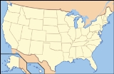
Alaska is the largest state in the United States by area. It is situated in the northwest extremity of the North American continent, with Canada to the east, the Arctic Ocean to the north, and the Pacific Ocean to the west and south, with Russia further west across the Bering Strait...
is the largest national forest in the United States
United States
The United States of America is a federal constitutional republic comprising fifty states and a federal district...
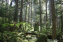
at 17 million acres (69,000 km²). Most of its area is part of the temperate rain forest
Temperate rain forest
Temperate rainforests are coniferous or broadleaf forests that occur in the temperate zone and receive high rainfall.-Definition:For temperate rain forests of North America, Alaback's definition is widely recognized:-Global distribution:...
WWF
World Wide Fund for Nature
The World Wide Fund for Nature is an international non-governmental organization working on issues regarding the conservation, research and restoration of the environment, formerly named the World Wildlife Fund, which remains its official name in Canada and the United States...
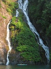
ecoregion, itself part of the larger Pacific temperate rain forest WWF ecoregion, and is remote enough to be home to many species of endangered and rare flora and fauna. Tongass encompasses islands of the Alexander Archipelago
Alexander Archipelago
The Alexander Archipelago is a long archipelago, or group of islands, of North America off the southeastern coast of Alaska. It contains about 1,100 islands, which are the tops of the submerged coastal mountains that rise steeply from the Pacific Ocean. Deep channels and fjords separate the...
, fjord
Fjord
Geologically, a fjord is a long, narrow inlet with steep sides or cliffs, created in a valley carved by glacial activity.-Formation:A fjord is formed when a glacier cuts a U-shaped valley by abrasion of the surrounding bedrock. Glacial melting is accompanied by rebound of Earth's crust as the ice...
s, glacier
Glacier
A glacier is a large persistent body of ice that forms where the accumulation of snow exceeds its ablation over many years, often centuries. At least 0.1 km² in area and 50 m thick, but often much larger, a glacier slowly deforms and flows due to stresses induced by its weight...
s, and peaks of the Coast Mountains
Coast Mountains
The Coast Mountains are a major mountain range, in the Pacific Coast Ranges, of western North America, extending from southwestern Yukon through the Alaska Panhandle and virtually all of the Coast of British Columbia. They are so-named because of their proximity to the sea coast, and are often...
. An international border
International Border
The India–Pakistan Border , known locally as the International Border , is the international boundary between India and Pakistan that demarcates the Indian states of Punjab, Rajasthan and Gujarat from the Pakistani provinces of Punjab and Sindh. Pakistan borders India in the east. The border...
with Canada
Canada
Canada is a North American country consisting of ten provinces and three territories. Located in the northern part of the continent, it extends from the Atlantic Ocean in the east to the Pacific Ocean in the west, and northward into the Arctic Ocean...
(British Columbia
British Columbia
British Columbia is the westernmost of Canada's provinces and is known for its natural beauty, as reflected in its Latin motto, Splendor sine occasu . Its name was chosen by Queen Victoria in 1858...
) runs along the crest of the Boundary Ranges
Boundary Ranges
The Boundary Ranges, also known in the singular and as the Alaska Boundary Range, are the largest and most northerly subrange of the Coast Mountains...
of the Coast Mountains
Coast Mountains
The Coast Mountains are a major mountain range, in the Pacific Coast Ranges, of western North America, extending from southwestern Yukon through the Alaska Panhandle and virtually all of the Coast of British Columbia. They are so-named because of their proximity to the sea coast, and are often...
(see also: Alaska boundary dispute
Alaska Boundary Dispute
The Alaska boundary dispute was a territorial dispute between the United States and Canada . It was resolved by arbitration in 1903. The dispute had been going on between the Russian and British Empires since 1821, and was inherited by the United States as a consequence of the Alaska Purchase in...
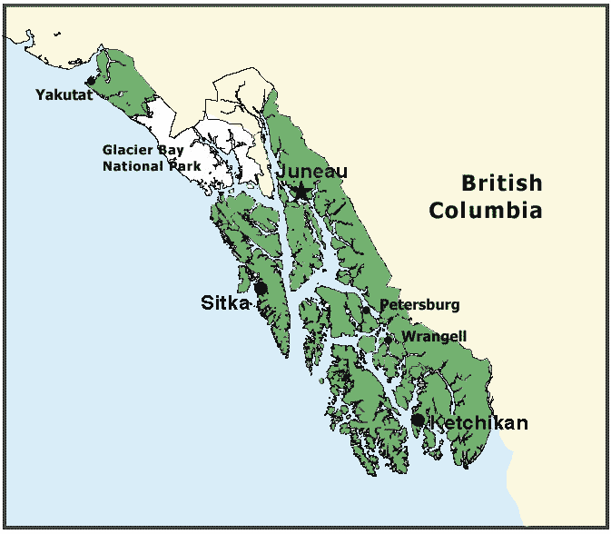
). The forest is administered from Forest Service offices in Ketchikan
Ketchikan, Alaska
Ketchikan is a city in Ketchikan Gateway Borough, Alaska, United States, the southeasternmost sizable city in that state. With an estimated population of 7,368 in 2010 within the city limits, it is the fifth most populous city in the state....
. There are local ranger
National Park Ranger
National Park Service Rangers are among the uniformed employees charged with protecting and preserving areas set aside in the National Park System by the United States Congress and/or the President of the United States...
district offices located in Craig
Craig, Alaska
Craig is a first-class city in the Prince of Wales-Hyder Census Area in the Unorganized Borough in the U.S. state of Alaska. The population was 1,397 at the 2000 census.-Geography:...
, Hoonah
Hoonah, Alaska
Hoonah is a Tlingit community on Chichagof Island, located in Alaska's "panhandle" in the southeast region of the state. It is 30 miles west of Juneau, across the Alaskan Inland Passage. Hoonah is the only first-class city on Chichagof Island, the 109th largest island in the world and the 5th...
, Juneau
Juneau, Alaska
The City and Borough of Juneau is a unified municipality located on the Gastineau Channel in the panhandle of the U.S. state of Alaska. It has been the capital of Alaska since 1906, when the government of the then-District of Alaska was moved from Sitka as dictated by the U.S. Congress in 1900...
, Ketchikan, Petersburg
Petersburg, Alaska
Petersburg is a city in Petersburg Census Area, Alaska, in the United States. According to 2009 Census Bureau estimates, the population of the city is 2,824 full time residents.- History :...
, Sitka, Thorne Bay
Thorne Bay, Alaska
Thorne Bay is a city in Prince of Wales-Hyder Census Area, Alaska, United States. At the 2000 census the population was 557.-Geography:Thorne Bay is located at ....
, Wrangell
Wrangell, Alaska
Wrangell is a city and borough in the U.S. state of Alaska. At the 2000 census the population was 2,308.Its Tlingit name is Ḵaachx̱aana.áakʼw . The Tlingit people residing in the Wrangell area, who were there centuries before Europeans, call themselves the Shtaxʼhéen Ḵwáan after the nearby Stikine...
, and Yakutat. In July 2009, the Obama Administration approved clearcut logging on 381 acres (1.5 km²) in the remaining old growth forests of the Tongass.
History
The Alexander Archipelago Forest ReserveAlexander Archipelago National Forest
Alexander Archipelago National Forest was established by the U.S. Forest Service in Alaska on 20 August 1902 by presidential order comprising . On 1 July 1908 the entire forest was combined with Tongass National Forest and the name was discontinued.-External links:** Text from Davis, Richard C.,...
was established by Theodore Roosevelt
Theodore Roosevelt
Theodore "Teddy" Roosevelt was the 26th President of the United States . He is noted for his exuberant personality, range of interests and achievements, and his leadership of the Progressive Movement, as well as his "cowboy" persona and robust masculinity...
in a presidential proclamation of 20 August 1902. Another presidential proclamation made by Roosevelt, on 10 September 1907, created the Tongass National Forest. On 1 July 1908, the two forests were joined, with the combined forest area encompassing most of southeast Alaska. Further presidential proclamations of 16 February 1909 (in the last months of the Roosevelt administration) and 10 June, and in 1925 (by Calvin Coolidge
Calvin Coolidge
John Calvin Coolidge, Jr. was the 30th President of the United States . A Republican lawyer from Vermont, Coolidge worked his way up the ladder of Massachusetts state politics, eventually becoming governor of that state...
) expanded the National Forest. An early supervisor of the forest was William Alexander Langille.
Description
The Tongass National Forest is home to about 75,000 people who are dependent on the land for their livelihoods. Several Alaska NativeAlaska Natives
Alaska Natives are the indigenous peoples of Alaska. They include: Aleut, Inuit, Tlingit, Haida, Tsimshian, Eyak, and a number of Northern Athabaskan cultures.-History:In 1912 the Alaska Native Brotherhood was founded...
tribes live throughout Southeast Alaska
Alaska Panhandle
Southeast Alaska, sometimes referred to as the Alaska Panhandle, is the southeastern portion of the U.S. state of Alaska, which lies west of the northern half of the Canadian province of British Columbia. The majority of Southeast Alaska's area is part of the Tongass National Forest, the United...
, such as the Tlingit, Haida, and Tsimshian
Tsimshian
The Tsimshian are an indigenous people of the Pacific Northwest Coast. Tsimshian translates to Inside the Skeena River. Their communities are in British Columbia and Alaska, around Terrace and Prince Rupert and the southernmost corner of Alaska on Annette Island. There are approximately 10,000...
. 31 communities are located within the forest; the largest is Juneau, the state capital, with a population of 31,000. The forest is named for the Tongass group of the Tlingit people, who inhabited the southernmost areas of the Alaska panhandle near what is now Ketchikan
Ketchikan, Alaska
Ketchikan is a city in Ketchikan Gateway Borough, Alaska, United States, the southeasternmost sizable city in that state. With an estimated population of 7,368 in 2010 within the city limits, it is the fifth most populous city in the state....
.
Ecology
Northern Pacific coastal forests
The Northern Pacific coastal forests are temperate coniferous forest ecoregion of the Pacific coast of North America. It occupies a narrow coastal zone of Alaska, between the Pacific Ocean and the northernmost Pacific Coast Ranges, covering an area of 23,300 square miles , extending from the...
and Pacific Coastal Mountain icefields and tundra ecoregions. Along with a region of the Central and North Coast regions of British Columbia
British Columbia Coast
The British Columbia Coast or BC Coast is Canada's western continental coastline on the Pacific Ocean. The usage is synonymous with the term West Coast of Canada....
designated by environmental groups as the Great Bear Rainforest
Great Bear Rainforest
The Great Bear Rainforest is the name coined by environmental groups in the mid-1990s to refer to a region of temperate rain forest in Canada, on the British Columbia Coast between Vancouver Island and Southeast Alaska...
, Tongass is part of the "perhumid rainforest zone," and the forest is primarily made up of western red cedar, sitka spruce
Sitka Spruce
Picea sitchensis, the Sitka Spruce, is a large coniferous evergreen tree growing to 50–70 m tall, exceptionally to 95 m tall, and with a trunk diameter of up to 5 m, exceptionally to 6–7 m diameter...
, and western hemlock
Western Hemlock
Tsuga heterophylla. the Western Hemlock, is a species of hemlock native to the west coast of North America, with its northwestern limit on the Kenai Peninsula, Alaska, and its southeastern limit in northern Sonoma County, California.-Habitat:...
. Tongass is Earth's largest remaining temperate rainforest. The terrain underlying Tongass is divided between karst
KARST
Kilometer-square Area Radio Synthesis Telescope is a Chinese telescope project to which FAST is a forerunner. KARST is a set of large spherical reflectors on karst landforms, which are bowlshaped limestone sinkholes named after the Kras region in Slovenia and Northern Italy. It will consist of...
(limestone
Limestone
Limestone is a sedimentary rock composed largely of the minerals calcite and aragonite, which are different crystal forms of calcium carbonate . Many limestones are composed from skeletal fragments of marine organisms such as coral or foraminifera....
rock, well-drained soil, and many caves), and granite
Granite
Granite is a common and widely occurring type of intrusive, felsic, igneous rock. Granite usually has a medium- to coarse-grained texture. Occasionally some individual crystals are larger than the groundmass, in which case the texture is known as porphyritic. A granitic rock with a porphyritic...
(poorly-drained soil).
Unique and protected creatures seldom found anywhere else in North America
North America
North America is a continent wholly within the Northern Hemisphere and almost wholly within the Western Hemisphere. It is also considered a northern subcontinent of the Americas...
inhabit the thousands of islands along the Alaska coast. Five species of salmon
Salmon
Salmon is the common name for several species of fish in the family Salmonidae. Several other fish in the same family are called trout; the difference is often said to be that salmon migrate and trout are resident, but this distinction does not strictly hold true...
, brown
Brown Bear
The brown bear is a large bear distributed across much of northern Eurasia and North America. It can weigh from and its largest subspecies, the Kodiak Bear, rivals the polar bear as the largest member of the bear family and as the largest land-based predator.There are several recognized...
and black bear
American black bear
The American black bear is a medium-sized bear native to North America. It is the continent's smallest and most common bear species. Black bears are omnivores, with their diets varying greatly depending on season and location. They typically live in largely forested areas, but do leave forests in...
, and Bald eagles
Bald Eagle
The Bald Eagle is a bird of prey found in North America. It is the national bird and symbol of the United States of America. This sea eagle has two known sub-species and forms a species pair with the White-tailed Eagle...
abound throughout the forest.
Though its land area is huge, about 40% of the Tongass is composed of wetlands, snow, ice, rock, and non-forest vegetation, while the remaining 10 million acres (40,468.6 km²) are forested. About 5 million acres (20,234.3 km²) are considered “productive old-growth”, and 4500000 acres (18,210.9 km²) of those are preserved as wilderness areas.
Historically, logging operations tended to concentrate on lower elevation, bigger tree ecosystems for harvesting; at present, approximately 78% of the land remains intact, i.e. 383000 acres (1,549.9 km²) out of 491000 acres (1,987 km²) original big tree, low elevation forest area. Given the high value of these areas for wildlife species, close to 70% of this big-tree old growth forest
Old growth forest
An old-growth forest is a forest that has attained great age , and thereby exhibits unique ecological features. An old growth forest has also usually reached a climax community...
is protected in reserves, and will never be eligible for harvest.
Of all of the big-tree old growth on the forest, including both low and higher elevation areas, no more than 11% of the remaining area will ever be harvested. Of the 5700000 acres (23,067.1 km²) “productive old-growth” on the Forest, 676000 acres (2,735.7 km²), or 12% of the old-growth on the Forest, are slated for harvest over the next 10 years.
Wilderness areas
There are 19 designated wilderness areasNational Wilderness Preservation System
The National Wilderness Preservation System of the United States protects federally managed land areas designated for preservation in their natural condition. It was established by the Wilderness Act upon the signature of President Lyndon B. Johnson on September 3, 1964...
within the Tongass National Forest, more than in any other National Forest. They contain over 5750000 acres (23,269.4 km²) of territory, also more than any other. From largest to smallest they are:
- Misty Fjords National Monument Wilderness
- Kootznoowoo WildernessKootznoowoo WildernessThe temperate rainforests of Admiralty Island's Kootznoowoo Wilderness are unique among the of federally protected Wilderness in Southeast Alaska....
- Tracy Arm-Fords Terror Wilderness
- Stikine-LeConte WildernessStikine-LeConte WildernessThe Stikine-LeConte Wilderness is on the mainland of southeast Alaska, southeast of Petersburg and north of Wrangell, Alaska. The boundary extends from Frederick Sound on the west to the Alaska-Canada boundary on the east. The wilderness is in size...
- Russell Fjord Wilderness
- South Baranof Wilderness
- West Chichagof-Yakobi WildernessWest Chichagof-Yakobi WildernessWest Chichagof-Yakobi Wilderness is a federally designated wilderness. It encompasses in Southeastern Alaska, in the United States. It includes Yakobi Island, the entire western side of Chichagof Island, as well as the many small island systems along their coasts.The wilderness was created...
- Endicott River WildernessEndicott River WildernessEndicott River Wilderness is a wilderness area in the U.S. state of Alaska. Designated by the United States Congress in 1980, it is located within the Tongass National Forest and is bordered by Glacier Bay Wilderness within Glacier Bay National Park on the west.-External links:* - Tongass...
- South Prince of Wales Wilderness
- South Etolin Wilderness
- Chuck River WildernessChuck River WildernessChuck River Wilderness is a wilderness area located within the Tongass National Forest in the U.S. state of Alaska. It was designated by the United States Congress in 1990....
- Tebenkof Bay Wilderness
- Kuiu Wilderness
- Petersburg Creek-Duncan Salt Chuck Wilderness
- Karta River WildernessKarta River WildernessKarta River Wilderness is a U. S. wilderness area, centrally located on Prince of Wales Island. It is north of Hollis, Alaska just east of the Kasaan Peninsula and may be accessed by a quick 10 minute plane ride or 30-minute boat ride....
- Pleasant/Lemesurier/Inian Islands Wilderness
- Coronation Island WildernessCoronation Island WildernessCoronation Island Wilderness is a wilderness area in the U.S. state of Alaska. It was designated by the United States Congress in 1980. The wilderness area encompasses the entirety of Coronation Island plus the Spanish Islands. It is part of Tongass National Forest, which is managed by the United...
- Warren Island Wilderness
- Maurille Islands Wilderness
Note: There are three other wilderness areas within the Alaska Panhandle region that are not part of Tongass National Forest, but are administered by the United States Fish and Wildlife Service
United States Fish and Wildlife Service
The United States Fish and Wildlife Service is a federal government agency within the United States Department of the Interior dedicated to the management of fish, wildlife, and natural habitats...
as part of the Alaska Maritime National Wildlife Refuge
Alaska Maritime National Wildlife Refuge
The Alaska Maritime National Wildlife Refuge is a United States National Wildlife Refuge comprising 2,400 islands, headlands, rocks, islets, spires and reefs in Alaska, with a total area of , of which is wilderness)...
. From largest to smallest they are the Forrester Island Wilderness
Forrester Island Wilderness
Forrester Island Wilderness is a wilderness area in the U.S. state of Alaska at Forrester Island . It was designated by the United States Congress in 1970...
, the Saint Lazaria Wilderness, and the Hazy Islands Wilderness
Hazy Islands Wilderness
Hazy Islands Wilderness is a wilderness area in the U.S. state of Alaska. It was first established as a National Wildlife Refuge in 1912, and officially designated as Wilderness in 1970 by the United States Congress. The islands are part of the Gulf of Alaska unit of the Alaska Maritime National...
. Also in the Panhandle, but not in Tongass National Forest, are the Glacier Bay Wilderness
Glacier Bay Wilderness
Glacier Bay Wilderness is a wilderness area in Glacier Bay National Park and Preserve in the U.S. state of Alaska. It consists of the park section of 3.28-million-acre Glacier Bay National Park and Preserve...
and a small part of the Wrangell-Saint Elias Wilderness
Wrangell-Saint Elias Wilderness
Wrangell-Saint Elias Wilderness is a wilderness area in Alaska, United States. At , it is the largest designated U.S. Wilderness Area, and lies within Wrangell-Saint Elias National Park and Preserve, the largest national park in the United States...
, which are both administered by the National Park Service
National Park Service
The National Park Service is the U.S. federal agency that manages all national parks, many national monuments, and other conservation and historical properties with various title designations...
.
Recreation
The Tongass National Forest offers outstanding recreation opportunities, many of which are only found in Alaska. The forest has close to one million visitors each year. Most come by cruise ship sailing through the Inside Passage of Southeast Alaska. The Forest Service provides forest interpreters and visitor programs at Mendenhall Glacier Visitor Center in Juneau, the Discovery Center in Ketchikan and forest interpreters on the state Marine Highway ferry system in Southeast Alaska. The Mendenhall Glacier Visitor Center was the first US Forest Service visitor center built in the nation, in 1962. The forest interpretive program on the state ferries began in the summer of 1968, making it the longest running naturalist program in the agency.There are approximately 150 rustic public recreation cabins for rent across the Tongass in remote locations, reachable by trail boat or floatplane. Many are fully accessible. There are 15 campgrounds across the forest, many in spectacular settings with views of a glacier and bald eagles. Six campgrounds offer advance reservations.
In addition, there are several spectacular bear viewing areas on the forest. The southern most site is in Hyder, Alaska. You can drive to Hyder through British Columbia
British Columbia
British Columbia is the westernmost of Canada's provinces and is known for its natural beauty, as reflected in its Latin motto, Splendor sine occasu . Its name was chosen by Queen Victoria in 1858...
. The Fish Creek site is open from mid-July through September for a small permit fee. Both black and brown bears can be seen in safety from an elevated viewing platform and boardwalk. Forest staff are on site to provide safety and answer questions. The Anan Bear Viewing area is only reachable by boat from Wrangell. Both black and brown bears are seen from early July through August. There is an extensive viewing platform and deck above the river for viewing in safety. A day pass is required before visiting the site. Pack Creek Bear Viewing area on Admiralty Island National Monument
Admiralty Island National Monument
Admiralty Island National Monument is located on Admiralty Island in Southeast Alaska. It was created December 1, 1978, and covers 955,747 acres of Tongass National Forest in the Panhandle of southeast Alaska...
is a 30-minute floatplane trip from Juneau. Brown bear
Brown Bear
The brown bear is a large bear distributed across much of northern Eurasia and North America. It can weigh from and its largest subspecies, the Kodiak Bear, rivals the polar bear as the largest member of the bear family and as the largest land-based predator.There are several recognized...
viewing occurs from June through September. The original bear viewing platform was built by the CCC Civilian Conservation Corps
Civilian Conservation Corps
The Civilian Conservation Corps was a public work relief program that operated from 1933 to 1942 in the United States for unemployed, unmarried men from relief families, ages 18–25. A part of the New Deal of President Franklin D...
in the 1930s. Today Forest Service and State Dept of Fish and Game staff live on site in summer to provide orientation to the area and answer questions. A permit is required to visit the area. In addition, both black and brown bears can be seen along many of the over 100 hiking trails on the Tongass National Forest.
Logging
World War II
World War II, or the Second World War , was a global conflict lasting from 1939 to 1945, involving most of the world's nations—including all of the great powers—eventually forming two opposing military alliances: the Allies and the Axis...
, the Forest Service
United States Forest Service
The United States Forest Service is an agency of the United States Department of Agriculture that administers the nation's 155 national forests and 20 national grasslands, which encompass...
set up long-term contracts with two pulp mills: the Ketchikan Pulp Company (KPC) and the Alaska Pulp Company. These contracts were scheduled to last 50 years, and originally intended to complement independent sawlog operations in the region. However, the two companies conspired to drive log prices down, put smaller logging operations out of business, and were major and recalcitrant polluters in their local areas. Ultimately, virtually all timber sales on the Tongass were purchased by one of these two companies.
In 1974, the KPC contract for Northern Prince of Wales was challenged by the Point Baker Association led by Alan Stein, Chuck Zieske and Herb Zieske. Federal District Court Judge Von Der Hydt ruled in their favor in December 1974, enjoining clearcutting of over 150 square miles (388.5 km²) of the north end of Prince of Wales Island. The suit threatened to halt clearcutting in the United States. In 1976, Congress removed the injunction in passing the National Forest Management Act, a direct response to their law suit. Over half the old growth timber was removed there by the mid 1990s.
An attempt to privatize the northern end of POW on this, our nation's, first national forest will be made by Senators Murkowski and Begich when they attempt to transfer the land to the Sealaska Corporation.
Much of the power of these companies lay in the long-term contracts themselves. The contracts guaranteed low prices to the pulp companies — in some cases resulting in trees being given away for "less than the price of a hamburger." The contracts were canceled in 1999, and the pulp mills closed their doors in the early 2000s.
In 2003, an appropriations bill rider required that all timber sales on the Tongass must be positive sales, meaning, no sales could be sold that undervalued the "stumpage" rate, or the value of the trees as established by the marketplace (2008 Appropriations Bill P.L. 110-161, H. Rept. 110-497, Sec. 411). However, the Forest Service also conducts NEPA analyses, layout, and administrative operations to support these sales, and as such, the government does not make a profit overall. Given the guaranteed low prices during contract days and the continued high cost of logging in Southeast Alaska today, one analysis concludes that, since 1980, the forest service has lost over a billion dollars in Tongass timber sales. Logging operations are not the only deficit-run programs, however. The Forest Service likens the overall deficit of the timber harvest program to the many other programs the agency operates at a deficit, including trail, cabin, and campground maintenance and subsistence programs.
High-grading (preferentially targeting for logging the most profitable forest types) has been prevalent on the Tongass throughout the era of industrial-scale logging there. For example, the forest type with the largest concentration of big trees -- volume class 7 -- originally comprised only 4% of the forested portion of the Tongass, and over two-thirds of it has been logged. Other high-grading has concentrated on stands of Alaska cedar and red cedar. The karst terrain often produces large trees and has fewer muskeg
Muskeg
Muskeg is an acidic soil type common in Arctic and boreal areas, although it is found in other northern climates as well. Muskeg is approximately synonymous with bogland but muskeg is the standard term in Western Canada and Alaska, while 'bog' is common elsewhere. The term is of Cree origin, maskek...
bogs, and has also been preferentially logged.
As of 2008, the forest service has released a new amendment to the Forest Plan for the Tongass Forest.
Roadless controversy
The most controversial logging in the Tongass has involved the roadless areasRoadless area conservation
Roadless area conservation is a conservation policy limiting road construction and the resulting environmental impact on designated areas of public land. In the United States, roadless area conservation has centered on U.S. Forest Service areas known as inventoried roadless areas...
. Southeast Alaska is an extensive landscape, with communities scattered across the archipelago on different islands, isolated from each other and the mainland road system. The road system that exists in the region is in place because of the resource extraction history in the region, primarily established by the Forest Service to enable timber harvest. Once in place, these roads serve to connect local communities and visitors to recreation, hunting, fishing, and subsistence opportunities long into the future. Essentially, these roads serve to provide essential infrastructure for local communities. However, installing roads in the vast wilderness areas of the Tongass is also a point of controversy for many in the American public, as reflected in the roadless area conservation
Roadless area conservation
Roadless area conservation is a conservation policy limiting road construction and the resulting environmental impact on designated areas of public land. In the United States, roadless area conservation has centered on U.S. Forest Service areas known as inventoried roadless areas...
movement.
The Tongass National Forest was included in the Roadless Initiative passed on 5 January 2001, during the last days of the Bill Clinton
Bill Clinton
William Jefferson "Bill" Clinton is an American politician who served as the 42nd President of the United States from 1993 to 2001. Inaugurated at age 46, he was the third-youngest president. He took office at the end of the Cold War, and was the first president of the baby boomer generation...
Administration, and the initiative prevented the construction of new roads in currently roadless areas of United States national forests.
However, several governors of western states soon joined forces with the timber industry to overturn the roadless policy. The George W. Bush Administration
George W. Bush administration
The presidency of George W. Bush began on January 20, 2001, when he was inaugurated as the 43rd President of the United States of America. The oldest son of former president George H. W. Bush, George W...
has declined to defend the policy in the courts and the U.S. Forest Service has largely exempted the Tongass from roadless protections.
In September 2006, a landmark court decision overturned Bush's repeal of the Roadless Rule, reverting to the 2001 roadless area protections established under president Clinton. However, the Tongass remained exempt from that ruling, and it is currently unclear what the fate of its vast roadless areas will be.
In June 2007, U.S. House
United States House of Representatives
The United States House of Representatives is one of the two Houses of the United States Congress, the bicameral legislature which also includes the Senate.The composition and powers of the House are established in Article One of the Constitution...
members added an amendment to the appropriations bill to block federally-funded road building in Tongass National Forest. Proponents of the amendment said that the federal timber program in Tongass is a dead loss for taxpayers, costing some $30 million annually, and noted that the Forest Service faces an estimated $900 million road maintenance backlog in the forest. Supporters of the bipartisan amendment included the Republicans for Environmental Protection. Representative Steve Chabot
Steve Chabot
Steven Joseph "Steve" Chabot is the U.S. Representative for . He is a member of the Republican Party. He previously represented the district from 1995 to 2009.-Early life, education and career:...
, an Ohio Republican who sponsored the amendment, said "I am not opposed to logging when it's done on the timber company's dime...But in this case, they are using the American taxpayer to subsidize these 200 jobs at the tune of $200,000 per job. That just makes no sense."
In March 2011, Judge John Sedwick
John W. Sedwick
John W. Sedwick is an American lawyer and judge. He is currently a judge on the United States District Court for the District of Alaska....
from the Anchorage federal district court, in his ruling, reinstated the Roadless Rule on roadless areas in the Tongass, but with three of the Forest Service's recent timber projects excluded from that ruling "without prejudice." Those projects were Iyouktug Timber Sales ROD (record of decision), Scratchings Timber Sale ROD II, and Kuiu Timber Sale Area ROD. The Order concluded in part:
- "Because the reasons proffered by the Forest Service in support of the Tongass Exemption were implausible, contrary to the evidence in the record, and contrary to Ninth Circuit precedent, the court concludes that promulgation of the Tongass Exemption was arbitrary and capricious.
- “With the passage of the Roadless Rule, inventoried roadless areas, ‘for better or worse, [were] more committed to pristine wilderness, and less amendable to road development for purposes permitted by the Forest Service.’”
- While the Forest Service may reevaluate its approach to roadless area management in the Tongass, it must comply with the requirements of the APA in doing so."
Native Corporation Lands
Native Corporation Lands are those designated by the Alaska Native Claims Settlement Act of 1971 (ANCSA). This Act awarded approximately 148500000 acres (600,958.7 km²) of Federal land in Alaska to private native corporations which were created under the ANCSA. 632000 acres (2,557.6 km²) of those lands were hand-picked old growth areas of the Tongass National Forest and are still surrounded by public National Forest land. These lands are now private and under the management of Sealaska, one of the native regional corporations created under the ANCSA.Transference of public National Forest land to a privately owned corporation removes it from protection by Federal law and allows the owners to use the land in whatever way they see fit without regard to the effects of the use on surrounding lands and ecosystems. This fact has caused much controversy involving the business interests of Native Regional Corporations and the personal interests of local Native and non-Native residents of Southeastern Alaska.
Currently Sealaska, a native regional corporation created under the ANCSA is asking for an amendment to the Act that would distribute additional land to Alaskan Natives. On April 23, 2009, Senator Murkowski and U.S. Rep. Don Young introduced a revised Sealaska bill (S. 881 and H.R 2099) that requests public lands that are both economically valuable and environmentally delicate. The controversy continues as to whether this bill is balanced enough on the environmental side to protect National Forest and local resident interests.
There is strong opposition to passage of S 881 coming from seven communities in the Tongass, most on Prince of Wales Island. In addition, there are fears expressed by the Territorial Sportsmen that the Northern Goshawk will be listed as endangered if the bill is passed. Similar concerns were expressed by the Alaska Outdoor Council in letters to Senators Murkowski and Begich and Governor Parnell.
See also
- Coeur Alaska, Inc. v. Southeast Alaska Conservation CouncilCoeur Alaska, Inc. v. Southeast Alaska Conservation CouncilCoeur Alaska, Inc. v. Southeast Alaska Conservation Council, 07-984 , is a United States Supreme Court case that was decided in favor of Coeur Alaska's permitted right to dump mine waste in a lake. The case addressed tailings from the Kensington mine, an underground mine located in Alaska...
- Fort TongassFort TongassFort Tongass was a United States Army base on Tongass Island, in the southernmost Alaska Panhandle, located adjacent to the village of the group of Tlingit people on the east side of the island. Fort Tongass was the first US Army base established in Alaska following its purchase from the Russian...
- Tongass IslandTongass IslandTongass Island, historically also spelled Tongas Island, is an island in the southern Alaska Panhandle, near the marine boundary with Canada at 54-40 N...
- Tongass PassageTongass PassageTongass Passage is a strait on the Canada-United States border between Alaska and British Columbia, located on the southwest side of Wales Island. Wales Island, and Pearse Island, to its northeast, were claimed by the United States prior to the settlement of the Alaska boundary dispute in 1903. ...
- Alexander Archipelago WolfAlexander Archipelago WolfThe Alexander Archipelago Wolf , also known as the Archipelago Wolf and the Islands Wolf, is a subspecies of the gray wolf, Canis lupus, and primarily resides in the areas in and around the Alexander Archipelago. This region composes a part of the Tongass National Forest, where this species makes...
External links
- U.S. Forest Service - Tongass National Forest
- Map of Ranger Districts
- A History of the U.S. Forest Service in Alaska
- Tongass National Forest Gallery
- Tongass Conservation Society
- Southeast Alaska Conservation Council - coalition of local groups working to preserve the Tongass
- Q&A with Kathie Durbin - chronicler of the struggle to preserve the Tongass (book referenced above)
- Temperate Rainforests of the North Pacific Coast
- Audubon Alaska: Tongass National Forest
- acres-of-public-land/
- The National Forest Foundation's Conservation Plan for Tongass National Forest