

Alexander Archipelago
Encyclopedia
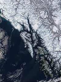
Archipelago
An archipelago , sometimes called an island group, is a chain or cluster of islands. The word archipelago is derived from the Greek ἄρχι- – arkhi- and πέλαγος – pélagos through the Italian arcipelago...
, or group of islands, of North America
North America
North America is a continent wholly within the Northern Hemisphere and almost wholly within the Western Hemisphere. It is also considered a northern subcontinent of the Americas...
off the southeastern coast of Alaska
Alaska
Alaska is the largest state in the United States by area. It is situated in the northwest extremity of the North American continent, with Canada to the east, the Arctic Ocean to the north, and the Pacific Ocean to the west and south, with Russia further west across the Bering Strait...
. It contains about 1,100 islands, which are the tops of the submerged coastal mountains that rise steeply from the Pacific Ocean
Pacific Ocean
The Pacific Ocean is the largest of the Earth's oceanic divisions. It extends from the Arctic in the north to the Southern Ocean in the south, bounded by Asia and Australia in the west, and the Americas in the east.At 165.2 million square kilometres in area, this largest division of the World...
. Deep channels and fjords separate the islands and cut them off from the mainland. The northern part of the Inside Passage
Inside Passage
The Inside Passage is a coastal route for oceangoing vessels along a network of passages which weave through the islands on the Pacific coast of North America. The route extends from southeastern Alaska, in the United States, through western British Columbia, in Canada, to northwestern Washington...
is sheltered by the islands as it winds its way among them.
The islands have irregular, steep coasts and dense evergreen
Evergreen
In botany, an evergreen plant is a plant that has leaves in all seasons. This contrasts with deciduous plants, which completely lose their foliage during the winter or dry season.There are many different kinds of evergreen plants, both trees and shrubs...
and temperate rain forest
Temperate rain forest
Temperate rainforests are coniferous or broadleaf forests that occur in the temperate zone and receive high rainfall.-Definition:For temperate rain forests of North America, Alaback's definition is widely recognized:-Global distribution:...
s.
In order of land area, the largest islands are Prince of Wales Island, Chichagof Island
Chichagof Island
Chichagof Island, or Shee Kaax, is an island in the Alexander Archipelago of the Alaska Panhandle. At long and wide, it has a land area of , making it the fifth largest island in the United States and the 109th largest island in the world. It's coastline measures 742 miles. There was a 2000...
, Admiralty Island
Admiralty Island
Admiralty Island is an island in the Alexander Archipelago in Southeast Alaska, at . It is 145 km long and 56 km wide with an area of 4,264.1 km² , making it the seventh largest island in the United States and the 132nd largest island in the world. It is one of the...
, Baranof Island
Baranof Island
Baranof Island, also sometimes called Baranov Island, Shee or Sitka Island, is an island in the northern Alexander Archipelago in the Alaska Panhandle, in Alaska. The name Baranof was given in 1805 by Imperial Russian Navy captain U. F. Lisianski to honor Alexander Andreyevich Baranov...
, Revillagigedo Island
Revillagigedo Island
Revillagigedo Island is an island in the Alexander Archipelago in Ketchikan Gateway Borough of the southeastern region of the U.S. state of Alaska. Running about 89 km north-south and 48 km east-west, it is 2,754.835 km² in area, making it the 12th largest island in the United...
, Kupreanof Island
Kupreanof Island
Kupreanof Island is an island in the Alexander Archipelago in southeastern Alaska. The island is long and wide with a total land area is , making it the 13th largest island in the United States and the 170th largest island in the world. The Lindenberg Peninsula, on the southeast side of the...
, Kuiu Island
Kuiu Island
Kuiu Island is an island in the Alexander Archipelago in southeastern Alaska. It lies between Kupreanof Island, to its east, and Baranof Island, to its west. The island is long, and 10–23 km wide. It is nearly cut in two by Affleck Canal. It has of land area, making it the 15th largest...
, Etolin Island
Etolin Island
Etolin Island is an island in the Alexander Archipelago of southeastern Alaska, USA, at . It is between Prince of Wales Island, to its west, and the Alaska mainland, to its east. It is southwest of Wrangell Island. It was first charted in 1793 by James Johnstone, one of George Vancouver's...
, Dall Island
Dall Island
Dall Island is an island in the Alexander Archipelago off the southeast coast of Alaska, just west of Prince of Wales Island and north of Canadian waters. Its peak elevation is 2,443 feet above sea level. Its land area is 254.02 square miles , making it the 28th largest island in the United States...
, Wrangell Island
Wrangell Island
Wrangell Island is in the Alexander Archipelago in the Alaska Panhandle of southeastern Alaska. It is long and 8–23 km wide. It has a land area of , making it the 29th largest island in the United States...
, Mitkof Island
Mitkof Island
Mitkof Island is an island in the Alexander Archipelago in southeast Alaska, at . between Kupreanof Island to the west and the Alaska mainland to the east. It is about wide and long with a land area of , making it the 30th largest island in the United States.The island is relatively flat with...
, Zarembo Island
Zarembo Island
Zarembo Island is an island in the Alexander Archipelago of southeastern Alaska, United States. It lies directly south of Mitkof Island and northwest of Etolin Island. To the northwest is Kupreanof Island and to the southwest is Prince of Wales Island. It has a land area of 183.14 sq mi , making it...
, Kosciusko Island
Kosciusko Island
Kosciusko Island is an island in the Alexander Archipelago of southeastern Alaska, USA. It lies near the northwest corner of Prince of Wales Island, just across the El Capitan Passage from the larger island. Kosciusko Island has a land area of 171.585 sq mi , making it the 38th largest island in...
, Kruzof Island
Kruzof Island
Kruzof Island is an island in the Alexander Archipelago in southeastern Alaska at . It is about west of Sitka, and is part of the City and Borough of Sitka. It was named in 1805 by Captain U.T. Lisianski as Crooze Island, after a Russian Admiral...
, Annette Island
Annette Island
Annette Island, or Taak'w Aan, is an island in Gravina Islands of the Alexander Archipelago of the Pacific Ocean on the southeastern coast of the U.S. state of Alaska. It is at . It is about long and about wide. The land area is...
, Gravina Island
Gravina Island
Gravina Island is an island in the Gravina Islands of the Alexander Archipelago in southeastern Alaska. It is long and about wide, with a land area of . The island had a population of 50 people at the 2000 census....
, and Yakobi Island
Yakobi Island
Yakobi Island is an island in the Alexander Archipelago of southeastern Alaska, United States. It lies just off the western edge of Chichagof Island, separated from it by Lisianski Inlet and Lisianski Strait...
. All the islands are rugged, densely forested, and have an abundance of wildlife.
The Tlingit and Kaigani Haida people are native to the area. The Tsimshian
Tsimshian
The Tsimshian are an indigenous people of the Pacific Northwest Coast. Tsimshian translates to Inside the Skeena River. Their communities are in British Columbia and Alaska, around Terrace and Prince Rupert and the southernmost corner of Alaska on Annette Island. There are approximately 10,000...
people found on Annette Island
Annette Island
Annette Island, or Taak'w Aan, is an island in Gravina Islands of the Alexander Archipelago of the Pacific Ocean on the southeastern coast of the U.S. state of Alaska. It is at . It is about long and about wide. The land area is...
are not originally from the area, having immigrated to the region from British Columbia
British Columbia
British Columbia is the westernmost of Canada's provinces and is known for its natural beauty, as reflected in its Latin motto, Splendor sine occasu . Its name was chosen by Queen Victoria in 1858...
in the late 19th century.
Ketchikan
Ketchikan, Alaska
Ketchikan is a city in Ketchikan Gateway Borough, Alaska, United States, the southeasternmost sizable city in that state. With an estimated population of 7,368 in 2010 within the city limits, it is the fifth most populous city in the state....
on Revillagigedo Island and Sitka
on Baranof Island are the largest towns on the islands. The most populous neighborhoods of the largest town in the region, Juneau
Juneau, Alaska
The City and Borough of Juneau is a unified municipality located on the Gastineau Channel in the panhandle of the U.S. state of Alaska. It has been the capital of Alaska since 1906, when the government of the then-District of Alaska was moved from Sitka as dictated by the U.S. Congress in 1900...
, are on the mainland, though portions of the city also lie on Douglas Island, which is a part of the archipelago.
Tourism, fishing, and logging are the main industries of the islands.
History
The first EuropeEurope
Europe is, by convention, one of the world's seven continents. Comprising the westernmost peninsula of Eurasia, Europe is generally 'divided' from Asia to its east by the watershed divides of the Ural and Caucasus Mountains, the Ural River, the Caspian and Black Seas, and the waterways connecting...
an to visit the archipelago was Aleksei Chirikov
Aleksei Chirikov
Aleksei Ilyich Chirikov was a Russian navigator and captain who along with Bering was the first Russian to reach North-West coast of North America. He discovered and charted some of the Aleutian Islands while he was deputy to Vitus Bering during the Great Northern Expedition.- Life and work :In...
in 1741, who sighted the coasts of Noyes
Noyes Island
Noyes Island is an island in the Alexander Archipelago of Southeast Alaska, United States. It lies just to the west of Prince of Wales Island. It was named in 1879 by William Healy Dall of the U.S. Coast and Geodetic Survey after William M. Noyes, also of the USC&GS, who was stationed in Alaska...
and Baker Island
Baker Island (Alaska)
Baker Island is an island in the Alexander Archipelago of southeastern Alaska, USA. It lies off the central west coast of Prince of Wales Island. Its closest significant island neighbors are Noyes Island to its northwest, Lulu Island directly to its north, and Suemez Island across Bucareli Bay to...
s (both off the west coast of Prince of Wales Island), as well as Baranof, Chichagof, Kruzof
Kruzof Island
Kruzof Island is an island in the Alexander Archipelago in southeastern Alaska at . It is about west of Sitka, and is part of the City and Borough of Sitka. It was named in 1805 by Captain U.T. Lisianski as Crooze Island, after a Russian Admiral...
and Yakobi Island
Yakobi Island
Yakobi Island is an island in the Alexander Archipelago of southeastern Alaska, United States. It lies just off the western edge of Chichagof Island, separated from it by Lisianski Inlet and Lisianski Strait...
s. In 1774 Juan José Pérez Hernández
Juan José Pérez Hernández
Juan José Pérez Hernández , often simply Juan Pérez, was an 18th century Spanish explorer. He was the first European to sight, examine, name, and record the islands near present-day British Columbia, Canada...
sighted the south coast of Dall Island, while Juan Francisco de la Bodega y Quadra
Juan Francisco de la Bodega y Quadra
Juan Francisco de la Bodega y Quadra was a Spanish naval officer born in Lima, Peru. Assigned to the Pacific coast Spanish Naval Department base at San Blas, in the Viceroyalty of New Spain , this navigator explored the Northwest Coast of North America as far north as present day Alaska.Juan...
entered Bucareli Bay
Bucareli Bay
Bucareli Bay is a bay in the Alexander Archipelago, in the southeastern part of the U.S. state of Alaska. It is located off the western coast of Prince of Wales Island, between Baker Island and Suemez Island. To the east it connects to various waterways, such as San Alberto Bay. To the west it...
off Prince of Wales Island the following year. In 1792 Jacinto Caamaño
Jacinto Caamaño
Jacinto Caamaño Moraleja was the leader of the last great Spanish exploration of Alaska and the Coast of British Columbia. He was a Knight of the Military Order of Calatrava. Born in Madrid, he came from an aristocratic Galician family, whose homestead was near Santiago de Compostela...
sighted Revillagigedo Island and the Gravina Islands
Gravina Islands
The Gravina Islands are part of the Alexander Archipelago in southeast Alaska. They are bounded by the Clarence Strait on the west and the Revillagigedo Channel on the east....
, discovering Clarence Strait
Clarence Strait
Clarence Strait, originally Duke of Clarence Strait, is a strait in southeastern Alaska, in the United States in the Alexander Archipelago. The strait separates Prince of Wales Island, on the west side, from Revillagigedo Island and Annette Island, on the east side...
. George Vancouver
George Vancouver
Captain George Vancouver RN was an English officer of the British Royal Navy, best known for his 1791-95 expedition, which explored and charted North America's northwestern Pacific Coast regions, including the coasts of contemporary Alaska, British Columbia, Washington and Oregon...
and his men
Vancouver Expedition
The Vancouver Expedition was a four-and-a-half-year voyage of exploration and diplomacy, commanded by Captain George Vancouver. The expedition circumnavigated the globe, touched five continents and changed the course of history for the indigenous nations and several European empires and their...
made an extensive survey of the archipelago in 1793 and 1794, circumnavigating both Revillagigedo and Admiralty Islands, charting the entirety of Kuiu Island
Kuiu Island
Kuiu Island is an island in the Alexander Archipelago in southeastern Alaska. It lies between Kupreanof Island, to its east, and Baranof Island, to its west. The island is long, and 10–23 km wide. It is nearly cut in two by Affleck Canal. It has of land area, making it the 15th largest...
, the east sides of Baranof and Chichagof Islands, and Etolin
Etolin Island
Etolin Island is an island in the Alexander Archipelago of southeastern Alaska, USA, at . It is between Prince of Wales Island, to its west, and the Alaska mainland, to its east. It is southwest of Wrangell Island. It was first charted in 1793 by James Johnstone, one of George Vancouver's...
, Wrangell, Zarembo
Zarembo Island
Zarembo Island is an island in the Alexander Archipelago of southeastern Alaska, United States. It lies directly south of Mitkof Island and northwest of Etolin Island. To the northwest is Kupreanof Island and to the southwest is Prince of Wales Island. It has a land area of 183.14 sq mi , making it...
, Mitkof
Mitkof Island
Mitkof Island is an island in the Alexander Archipelago in southeast Alaska, at . between Kupreanof Island to the west and the Alaska mainland to the east. It is about wide and long with a land area of , making it the 30th largest island in the United States.The island is relatively flat with...
, and Kupreanof Islands. Within a decade the Russia
Russia
Russia or , officially known as both Russia and the Russian Federation , is a country in northern Eurasia. It is a federal semi-presidential republic, comprising 83 federal subjects...
ns had traversed Peril Strait
Peril Strait
Peril Strait or Háat Ishkáak is a strait in the Alexander Archipelago in southeastern Alaska. It is between Chichagof Island to its north and Baranof Island and Catherine Island to its south. The strait is long and reaches from Salisbury Sound on the west to the Chatham Strait on the east...
separating Chichagof and Baranof Islands, and in the following decades found the straits and passages separating several of the other major islands. An 1844 Russian chart shows Kupreanof separated from Mitkof Island and Etolin, Wrangell, Woronkofski
Woronkofski Island
Woronkofski Island is an island in the Alexander Archipelago of southeastern Alaska, United States. It is separated from Wrangell Island to the east by Zimovia Strait, just west of the city of Wrangell; to the west it is separated from Zarembo Island by Stikine Strait, and to the south from Etolin...
, and Zarembo Islands separated from each other.
The archipelago was a locus of the Maritime Fur Trade
Maritime Fur Trade
The Maritime Fur Trade was a ship-based fur trade system that focused on acquiring furs of sea otters and other animals from the indigenous peoples of the Pacific Northwest Coast and natives of Alaska. The furs were mostly sold in China in exchange for tea, silks, porcelain, and other Chinese...
during the early 19th century. Control of the islands passed from Russia to the United States with the Alaska Purchase
Alaska purchase
The Alaska Purchase was the acquisition of the Alaska territory by the United States from Russia in 1867 by a treaty ratified by the Senate. The purchase, made at the initiative of United States Secretary of State William H. Seward, gained of new United States territory...
in 1867.
According to Donald Orth's Dictionary of Alaska Place Names (p. 64), the Alexander Archipelago received its name from the U.S. Coast and Geodetic Survey in 1867. The island chain is named for Tsar Alexander
Alexander II of Russia
Alexander II , also known as Alexander the Liberator was the Emperor of the Russian Empire from 3 March 1855 until his assassination in 1881...
of Russia.
On an 1860 map of Russian America (Alaska), the island group is called the King George III Archipelago.
See also
- Alexander Archipelago WolfAlexander Archipelago WolfThe Alexander Archipelago Wolf , also known as the Archipelago Wolf and the Islands Wolf, is a subspecies of the gray wolf, Canis lupus, and primarily resides in the areas in and around the Alexander Archipelago. This region composes a part of the Tongass National Forest, where this species makes...
- Catherine IslandCatherine Island (Alaska)Catherine Island is an island in the Alexander Archipelago of southeastern Alaska, USA. It is part of the City and Borough of Sitka and lies just off the northeast corner of Baranof Island, separated from it by Portage Arm. The U.S. Forest Service named Catherine Island in 1935 after Catherine I of...
- British Columbia CoastBritish Columbia CoastThe British Columbia Coast or BC Coast is Canada's western continental coastline on the Pacific Ocean. The usage is synonymous with the term West Coast of Canada....
- Boundary RangesBoundary RangesThe Boundary Ranges, also known in the singular and as the Alaska Boundary Range, are the largest and most northerly subrange of the Coast Mountains...
- Bell IslandBell Island (Alaska)Bell Island is an island in the Alexander Archipelago in Southeast Alaska, U.S.A. It is long, lying in Behm Canal, north of Revillagigedo Island. George Vancouver first visited the island on August 12, 1793, in the evening dining on its south coast...