

Tin tabernacle
Encyclopedia
Tin tabernacles were a type of prefabricated building made from corrugated iron developed in the mid 19th century initially in Great Britain. Corrugated iron was first used for roofing in London in 1829 by Henry Robinson Palmer
and the patent sold to Richard Walker who advertised "portable buildings for export" in 1832. The technology for producing the corrugated sheets improved and to prevent corrosion the sheets were galvanised
with a coating of zinc
, a process developed by Stanislas Sorel
in Paris in the 1830s. After 1850 many types of prefabricated buildings were produced including churches, chapels and mission halls.
, Humphrey's and Frederick Braby in London, Isaac Dixon and Co and Francis Morton in Liverpool, E T Bellhouse
in Manchester and A & J Main & Co of Glasgow manufactured a range of iron buildings that included houses, village halls, sports pavilions, warehouses, hospital wards, chapels and churches. Many of their products were exported to Canada, Africa, and to California and Australia during the gold rush
es. Corrugated iron buildings were exhibited at the Great Exhibition in 1851. Isaac Dixon's 1874 catalogue was aimed at the landed gentry
, railway proprietors and shippers while Francis Morton's company had a dedicated church building department and its 1879 catalogue reported nearly 70 churches, chapels and school houses built in the United Kingdom.
was a time of great population expansion and movement. Towns and cities expanded as the workforce moved into the new industrial areas resulting in the building of more than 4,000 churches during the mid 19th century and an upsurge of nonconformism
led to a demand for even more buildings. The Church of England
, influenced by Pugin, the Cambridge Camden Society
and John Ruskin
, was initially sceptical about corrugated iron buildings. However manufacturers found other markets, notably in the colonies of the British Empire
where 19 such churches were erected in Melbourne, Australia
alone by 1851. A 65 feet by 40 feet church built entirely of cast
and wrought iron
clad in corrugated iron was built in Jamaica
at a cost of £1,000. William Morris
, founder of the Arts and Crafts Movement
, wrote a pamphlet in 1890 decrying the corrugated iron buildings "that were spreading like a pestilence over the country."
Churches, chapels and mission halls were built in the new industrial areas, pit villages, near railway works and more isolated rural and coastal locations. Landowners or employers frequently donated plots of land and sometimes donated the cost of the building although many were funded by public subsription.
The 3rd Marquess of Bute
provided the first Roman Catholic cathedral to be erected in Oban
in 1886. It was lavishly decorated and furnished and lasted for 50 years until it was replaced.
The early tin churches were easily erected, but at an average cost of between £2 and £4 per sitting, were quite expensive. St Mark's Church in Birkenhead
was built in 1867 costing over £2,000 for 500 seats. Prices decreased towards the end of the century towards £1 per sitting. David Rowell & Co's catalogue of 1901 advertised a church to seat 400 persons, delivered to the nearest railway station and erected on the purchaser's foundation, at a cost of £360. Isaac Dixon's 1896 catalogue mentioned the company had supplied nearly 150 churches over the previous ten years and the price had dropped from 35 shilling
s to 20 shillings per sitting plus the cost of foundations, heating and lighting which could add another £70 for a church to seat £200.
Several tin tabernacles survive as places of worship, some have listed building status and some have been converted to other uses. Some redundant chapels have been moved to museums for preservation. St Chad's Mission Church was moved from near Telford
to the Ironbridge Gorge Museum Trust
's Blists Hill Victorian Town
in Shropshire, while St Saviour's Church from Westhouses
in Derbyshire may be seen at the Midland Railway Centre's Swanwick Junction
site.
Henry Robinson Palmer
Henry Robinson Palmer was a British civil engineer who designed the world's first monorail system and the first elevated railsystem...
and the patent sold to Richard Walker who advertised "portable buildings for export" in 1832. The technology for producing the corrugated sheets improved and to prevent corrosion the sheets were galvanised
Galvanization
Galvanization is the process of applying a protective zinc coating to steel or iron, in order to prevent rusting. The term is derived from the name of Italian scientist Luigi Galvani....
with a coating of zinc
Zinc
Zinc , or spelter , is a metallic chemical element; it has the symbol Zn and atomic number 30. It is the first element in group 12 of the periodic table. Zinc is, in some respects, chemically similar to magnesium, because its ion is of similar size and its only common oxidation state is +2...
, a process developed by Stanislas Sorel
Stanislas Sorel
Stanislas Sorel was a French engineer, raised the son of a poor clock-maker.Sorel filed a patent on 10 May 1837 for a "galvanic" method of protecting iron from rust by either coating it in a bath of molten zinc or by covering it with galvanic paint...
in Paris in the 1830s. After 1850 many types of prefabricated buildings were produced including churches, chapels and mission halls.
Manufacturers
Several firms such as David Rowell & Co.David Rowell & Co.
David Rowell & Co. was a company based in Westminster, London that fabricated wrought iron and wire rope, built suspension footbridges, and structural steel frame buildings. They were established in 1855 and closed in 1970.-History:...
, Humphrey's and Frederick Braby in London, Isaac Dixon and Co and Francis Morton in Liverpool, E T Bellhouse
David Bellhouse
David Bellhouse was an English builder who did much to shape Victorian era Manchester, both physically and socially.Born in Leeds, Bellhouse received no formal education. An autodidact, he taught himself to read and write and the elements of arithmetic and technical drawing...
in Manchester and A & J Main & Co of Glasgow manufactured a range of iron buildings that included houses, village halls, sports pavilions, warehouses, hospital wards, chapels and churches. Many of their products were exported to Canada, Africa, and to California and Australia during the gold rush
Gold rush
A gold rush is a period of feverish migration of workers to an area that has had a dramatic discovery of gold. Major gold rushes took place in the 19th century in Australia, Brazil, Canada, South Africa, and the United States, while smaller gold rushes took place elsewhere.In the 19th and early...
es. Corrugated iron buildings were exhibited at the Great Exhibition in 1851. Isaac Dixon's 1874 catalogue was aimed at the landed gentry
Landed gentry
Landed gentry is a traditional British social class, consisting of land owners who could live entirely off rental income. Often they worked only in an administrative capacity looking after the management of their own lands....
, railway proprietors and shippers while Francis Morton's company had a dedicated church building department and its 1879 catalogue reported nearly 70 churches, chapels and school houses built in the United Kingdom.
History
The Industrial RevolutionIndustrial Revolution
The Industrial Revolution was a period from the 18th to the 19th century where major changes in agriculture, manufacturing, mining, transportation, and technology had a profound effect on the social, economic and cultural conditions of the times...
was a time of great population expansion and movement. Towns and cities expanded as the workforce moved into the new industrial areas resulting in the building of more than 4,000 churches during the mid 19th century and an upsurge of nonconformism
Nonconformism
Nonconformity is the refusal to "conform" to, or follow, the governance and usages of the Church of England by the Protestant Christians of England and Wales.- Origins and use:...
led to a demand for even more buildings. The Church of England
Church of England
The Church of England is the officially established Christian church in England and the Mother Church of the worldwide Anglican Communion. The church considers itself within the tradition of Western Christianity and dates its formal establishment principally to the mission to England by St...
, influenced by Pugin, the Cambridge Camden Society
Cambridge Camden Society
The Cambridge Camden Society, later known as the Ecclesiological Society from 1845 when it moved to London, was a learned architectural society founded in 1839 by undergraduates at Cambridge University to promote "the study of Gothic Architecture, and of Ecclesiastical Antiques." Its activities...
and John Ruskin
John Ruskin
John Ruskin was the leading English art critic of the Victorian era, also an art patron, draughtsman, watercolourist, a prominent social thinker and philanthropist. He wrote on subjects ranging from geology to architecture, myth to ornithology, literature to education, and botany to political...
, was initially sceptical about corrugated iron buildings. However manufacturers found other markets, notably in the colonies of the British Empire
British Empire
The British Empire comprised the dominions, colonies, protectorates, mandates and other territories ruled or administered by the United Kingdom. It originated with the overseas colonies and trading posts established by England in the late 16th and early 17th centuries. At its height, it was the...
where 19 such churches were erected in Melbourne, Australia
Melbourne
Melbourne is the capital and most populous city in the state of Victoria, and the second most populous city in Australia. The Melbourne City Centre is the hub of the greater metropolitan area and the Census statistical division—of which "Melbourne" is the common name. As of June 2009, the greater...
alone by 1851. A 65 feet by 40 feet church built entirely of cast
Cast iron
Cast iron is derived from pig iron, and while it usually refers to gray iron, it also identifies a large group of ferrous alloys which solidify with a eutectic. The color of a fractured surface can be used to identify an alloy. White cast iron is named after its white surface when fractured, due...
and wrought iron
Wrought iron
thumb|The [[Eiffel tower]] is constructed from [[puddle iron]], a form of wrought ironWrought iron is an iron alloy with a very low carbon...
clad in corrugated iron was built in Jamaica
Jamaica
Jamaica is an island nation of the Greater Antilles, in length, up to in width and 10,990 square kilometres in area. It is situated in the Caribbean Sea, about south of Cuba, and west of Hispaniola, the island harbouring the nation-states Haiti and the Dominican Republic...
at a cost of £1,000. William Morris
William Morris
William Morris 24 March 18343 October 1896 was an English textile designer, artist, writer, and socialist associated with the Pre-Raphaelite Brotherhood and the English Arts and Crafts Movement...
, founder of the Arts and Crafts Movement
Arts and Crafts movement
Arts and Crafts was an international design philosophy that originated in England and flourished between 1860 and 1910 , continuing its influence until the 1930s...
, wrote a pamphlet in 1890 decrying the corrugated iron buildings "that were spreading like a pestilence over the country."
Churches, chapels and mission halls were built in the new industrial areas, pit villages, near railway works and more isolated rural and coastal locations. Landowners or employers frequently donated plots of land and sometimes donated the cost of the building although many were funded by public subsription.
The 3rd Marquess of Bute
John Crichton-Stuart, 3rd Marquess of Bute
John Patrick Crichton-Stuart, 3rd Marquess of Bute KT, KSG, KGCHS was a landed aristocrat, industrial magnate, antiquarian, scholar, philanthropist and architectural patron.-Early life:...
provided the first Roman Catholic cathedral to be erected in Oban
Oban
Oban Oban Oban ( is a resort town within the Argyll and Bute council area of Scotland. It has a total resident population of 8,120. Despite its small size, it is the largest town between Helensburgh and Fort William and during the tourist season the town can be crowded by up to 25,000 people. Oban...
in 1886. It was lavishly decorated and furnished and lasted for 50 years until it was replaced.
The early tin churches were easily erected, but at an average cost of between £2 and £4 per sitting, were quite expensive. St Mark's Church in Birkenhead
Birkenhead
Birkenhead is a town within the Metropolitan Borough of Wirral in Merseyside, England. It is on the Wirral Peninsula, along the west bank of the River Mersey, opposite the city of Liverpool...
was built in 1867 costing over £2,000 for 500 seats. Prices decreased towards the end of the century towards £1 per sitting. David Rowell & Co's catalogue of 1901 advertised a church to seat 400 persons, delivered to the nearest railway station and erected on the purchaser's foundation, at a cost of £360. Isaac Dixon's 1896 catalogue mentioned the company had supplied nearly 150 churches over the previous ten years and the price had dropped from 35 shilling
Shilling
The shilling is a unit of currency used in some current and former British Commonwealth countries. The word shilling comes from scilling, an accounting term that dates back to Anglo-Saxon times where it was deemed to be the value of a cow in Kent or a sheep elsewhere. The word is thought to derive...
s to 20 shillings per sitting plus the cost of foundations, heating and lighting which could add another £70 for a church to seat £200.
Several tin tabernacles survive as places of worship, some have listed building status and some have been converted to other uses. Some redundant chapels have been moved to museums for preservation. St Chad's Mission Church was moved from near Telford
Telford
Telford is a large new town in the borough of Telford and Wrekin and ceremonial county of Shropshire, England, approximately east of Shrewsbury, and west of Birmingham...
to the Ironbridge Gorge Museum Trust
Ironbridge Gorge Museum Trust
Ironbridge Gorge Museum Trust is an industrial heritage organisation which runs ten museums and manages 35 historic sites within the Ironbridge Gorge in Shropshire, England, widely considered as the birthplace of the Industrial Revolution....
's Blists Hill Victorian Town
Blists Hill Victorian Town
Blists Hill is an open air museum, one of ten museums operated by the Ironbridge Gorge Museum Trust, built on a former industrial complex located in the Madeley area of Telford, Shropshire, England...
in Shropshire, while St Saviour's Church from Westhouses
Westhouses
Westhouses is a village within Derbyshire, situated close to the town of Alfreton. It is in the Bolsover district of the county. Named after West House Farm, the settlement was founded in the 1870s.- Railway :...
in Derbyshire may be seen at the Midland Railway Centre's Swanwick Junction
Swanwick Junction railway station
Swanwick Junction railway station is a heritage railway station situated on the former Ambergate to Pye Bridge Line which closed in 1968, but has been partially reopened by the Midland Railway - Butterley. Despite the station's name it is some distance from Swanwick.There was originally no station...
site.
Examples in Britain
| Name | Location | Photograph | Notes |
|---|---|---|---|
| Abenbury Church | Abenbury Abenbury Abenbury is a local government community, the lowest tier of local government, part of the Wrexham County Borough in Wales. It is situated south-east of Wrexham town and includes the village of Pentre Maelor and part of the Wrexham Industrial Estate.... , Wrexham, Wales 53.0407°N 2.9488°W |
Now disused, the church stands in an isolated position close to Plas Issa Farm on the Cefn Park estate, | |
| St John's Church | Adlington Adlington, Cheshire Adlington is a village and civil parish in the unitary authority of Cheshire East and the ceremonial county of Cheshire, England. It is known as Eduluintune in the Domesday Book. According to the 2001 census the civil parish had a population of 1,081 people across 401 households... , Cheshire Cheshire Cheshire is a ceremonial county in North West England. Cheshire's county town is the city of Chester, although its largest town is Warrington. Other major towns include Widnes, Congleton, Crewe, Ellesmere Port, Runcorn, Macclesfield, Winsford, Northwich, and Wilmslow... 53.3195°N 2.1137°W |
St John's Church was built in 1892, and continues in active use as an Anglican Anglicanism Anglicanism is a tradition within Christianity comprising churches with historical connections to the Church of England or similar beliefs, worship and church structures. The word Anglican originates in ecclesia anglicana, a medieval Latin phrase dating to at least 1246 that means the English... mission church to St Peter's Church, Prestbury St Peter's Church, Prestbury St Peter's Church is the parish church of Prestbury, Cheshire, England. It is probably the fourth church on the site. The third, the Norman Chapel, stands in the churchyard. The church has been designated by English Heritage as a Grade I listed building. The Norman Chapel, the lychgate and... . |
|
| Mission Church | Alhampton, Somerset Somerset The ceremonial and non-metropolitan county of Somerset in South West England borders Bristol and Gloucestershire to the north, Wiltshire to the east, Dorset to the south-east, and Devon to the south-west. It is partly bounded to the north and west by the Bristol Channel and the estuary of the... 51.1098°N 2.5327°W |
The church was built in 1892 at a cost of £250; it seats 55 people. It continues in active use as a mission church to St Mary Magdalene, Ditcheat Church of St Mary Magdalene, Ditcheat The Church of St Mary Magdalen in Ditcheat, Somerset, England has 12th century origins. It has been designated as a Grade I listed building.... . |
|
| St Felix Chapel | Babingley Babingley Babingley is one of Norfolk's lost villages. This small parish was located on the western side of the A149, 1 mile north-west of Castle Rising, and 5½ miles north-north-east of King's Lynn. Today, the village of Babingley is constituted by several houses on the A149 - the King's Lynn to Hunstanton... , Norfolk Norfolk Norfolk is a low-lying county in the East of England. It has borders with Lincolnshire to the west, Cambridgeshire to the west and southwest and Suffolk to the south. Its northern and eastern boundaries are the North Sea coast and to the north-west the county is bordered by The Wash. The county... 52.8089°N 0.4839°W |
Unusually, this is a thatched, cruciform tin tabernacle. It was erected in 1880 and was at one time an Anglican Anglicanism Anglicanism is a tradition within Christianity comprising churches with historical connections to the Church of England or similar beliefs, worship and church structures. The word Anglican originates in ecclesia anglicana, a medieval Latin phrase dating to at least 1246 that means the English... parish church Parish church A parish church , in Christianity, is the church which acts as the religious centre of a parish, the basic administrative unit of episcopal churches.... . It was made redundant Redundant church A redundant church is a church building that is no longer required for regular public worship. The phrase is particularly used to refer to former Anglican buildings in the United Kingdom, but may refer to any disused church building around the world... by the Church of England Church of England The Church of England is the officially established Christian church in England and the Mother Church of the worldwide Anglican Communion. The church considers itself within the tradition of Western Christianity and dates its formal establishment principally to the mission to England by St... , and is being used by the British Orthodox Church British Orthodox Church The British Orthodox Church is a small Oriental Orthodox jurisdiction, canonically part of the Coptic Patriarchate of Alexandria. Its mission is to the people of the British Isles, and though it is Orthodox in its faith and practice, it remains British in its ethos... . |
|
| Oldfield Park Methodist Church | Bath, Somerset Somerset The ceremonial and non-metropolitan county of Somerset in South West England borders Bristol and Gloucestershire to the north, Wiltshire to the east, Dorset to the south-east, and Devon to the south-west. It is partly bounded to the north and west by the Bristol Channel and the estuary of the... |
Built in about 1892, the church closed in 2009. | |
| Church of the Ascension | Bedmond Bedmond Bedmond is a village in Hertfordshire, England.Bedmond is the birthplace of Nicholas Breakspear, the only Englishman to ever be Pope. Nicholas Breakspear was born at Bedmond Farm around 1100 AD, and the site where his home stood is marked by a plaque.... , Hertfordshire Hertfordshire Hertfordshire is a ceremonial and non-metropolitan county in the East region of England. The county town is Hertford.The county is one of the Home Counties and lies inland, bordered by Greater London , Buckinghamshire , Bedfordshire , Cambridgeshire and... 51.7230°N 0.4108°W |
This church was built in 1880 at a cost of £80. A new copper-coated steeple was added in 2005. It continues to be an active church in the parish of St Lawrence, Abbots Langley Abbots Langley Abbots Langley is a large village and civil parish in the English county of Hertfordshire. It is an old settlement and is mentioned in the Domesday Book. Economically the village is closely linked to Watford and was formerly part of the Watford Rural District... . |
|
| St Barnabas' Church | Blackwater Blackwater, Isle of Wight Blackwater is a village on the Isle of Wight. It is located three kilometres south of Newport, close to the geographic centre of the island.British pop artist Robbie Williams once visited Blackwater for three nights to get away from the media... , Isle of Wight Isle of Wight The Isle of Wight is a county and the largest island of England, located in the English Channel, on average about 2–4 miles off the south coast of the county of Hampshire, separated from the mainland by a strait called the Solent... |
Now redundant Redundant church A redundant church is a church building that is no longer required for regular public worship. The phrase is particularly used to refer to former Anglican buildings in the United Kingdom, but may refer to any disused church building around the world... ; has been used for a retail business. |
|
| St Matthew's Church | Boultham Boultham Boultham is a suburb of Lincoln, Lincolnshire, England.-Geography:The ecclesiastical parish of Boultham covers most of Lincoln west of the River Witham near Lincoln High Street. The northern boundary is defined by Brayford Pool and the Fossdyke as far as Carholme Golf Course. The parish includes... , Lincoln 53.2206°N 0.5532°W |
St Matthew's was created as a chapel of ease Chapel of ease A chapel of ease is a church building other than the parish church, built within the bounds of a parish for the attendance of those who cannot reach the parish church conveniently.... to St Helen's, Boultham, in 1912, to serve workers in local factories. It was extended in 1924, but has since closed, and has been damaged by fire. |
|
| Shaftesbury Hall | Bowes Park Bowes Park Bowes Park is situated on the borders of Wood Green, Palmers Green and Bounds Green in London, England. The postcode for Bowes Park is N22. The border between the London boroughs of Enfield and Haringey goes through the area.- History :... , London London London is the capital city of :England and the :United Kingdom, the largest metropolitan area in the United Kingdom, and the largest urban zone in the European Union by most measures. Located on the River Thames, London has been a major settlement for two millennia, its history going back to its... 51.6071°N 0.1210°W |
The hall was built in the middle of the 19th century as a chapel for railway workers, next to Bowes Park railway station Bowes Park railway station Bowes Park railway station is in the London Borough of Haringey in north London, and is on the boundary of Travelcard Zone 3 and Travelcard Zone 4. The station and all trains serving it are operated by First Capital Connect, on the Hertford Loop Line... . As of 2011 the hall is owned by the Samaritans Samaritans (charity) Samaritans is a registered charity aimed at providing emotional support to anyone in emotional distress or at risk of suicide throughout the United Kingdom and Ireland, often through their telephone helpline. The name comes from the Biblical parable of the Good Samaritan, though the organisation... , and plans have been submitted for the development of the site, but these are being opposed by local residents. |
|
| All Saints Church | Brokerswood, Wiltshire Wiltshire Wiltshire is a ceremonial county in South West England. It is landlocked and borders the counties of Dorset, Somerset, Hampshire, Gloucestershire, Oxfordshire and Berkshire. It contains the unitary authority of Swindon and covers... 51.2685°N 2.2348°W |
This was built originally in Southwick Southwick, Wiltshire Southwick is a rural village southwest of the county town of Trowbridge, Wiltshire, in England. It is separated from Trowbridge only by the Southwick Country Park, which consists of of open fields. The majority of the village lies south of the A361, which runs through the village, linking... to replace an iron church that has been destroyed by fire in 1897. In 1905 it was moved to Brokerswood. It was restored in the 1990s and is still in active use. |
|
| St Mary's Church | Burgh Parva, Melton Constable Melton Constable Melton Constable is a village and civil parish in the English county of Norfolk.It covers an area of and had a population of 518 in 225 households as of the 2001 census.For the purposes of local government, it falls within the district of North Norfolk... , Norfolk Norfolk Norfolk is a low-lying county in the East of England. It has borders with Lincolnshire to the west, Cambridgeshire to the west and southwest and Suffolk to the south. Its northern and eastern boundaries are the North Sea coast and to the north-west the county is bordered by The Wash. The county... 52.8607°N 1.0340°W |
St Mary's was built in 1903 in the churchyard of an abandoned medieval Middle Ages The Middle Ages is a periodization of European history from the 5th century to the 15th century. The Middle Ages follows the fall of the Western Roman Empire in 476 and precedes the Early Modern Era. It is the middle period of a three-period division of Western history: Classic, Medieval and Modern... church to serve as the parish church of Melton Constable. It continues in active use, its benefice being united with those of three other local churches. |
|
| Former Railway Mission | Bury St Edmunds, Suffolk Suffolk Suffolk is a non-metropolitan county of historic origin in East Anglia, England. It has borders with Norfolk to the north, Cambridgeshire to the west and Essex to the south. The North Sea lies to the east... 52.2539 °N 0.7138°W |
A Railway Mission Railway Mission The Railway Mission is a British mission devoted to the rail industry. It was founded in 1881 based in mission halls, and now operates a chaplaincy service. In the early days of the Railway Mission there were a number of mission halls at railway stations throughout the country, including one at... by Bury St Edmunds railway station Bury St Edmunds railway station Bury St Edmunds railway station serves the town of Bury St Edmunds in Suffolk, England. The station, and all trains calling there, are operated by National Express East Anglia.-Historical Services:... was opened for the railway workers who raised money to build it in 1900. The chapel, its furniture and fittings cost cost £317 7s 7d and was supplied by Boulton and Paul from Norwich. It is now used as a Seventh Day Adventist Church. |
|
| St Mary's Church | Cadgwith Cadgwith Cadgwith is a village and fishing port in Cornwall, United Kingdom. It is situated on the Lizard Peninsula between The Lizard and Coverack.-History:... , Cornwall Cornwall Cornwall is a unitary authority and ceremonial county of England, within the United Kingdom. It is bordered to the north and west by the Celtic Sea, to the south by the English Channel, and to the east by the county of Devon, over the River Tamar. Cornwall has a population of , and covers an area of... 49.9877°N 5.1806°W |
St Mary's Church is situated on a footpath in the valley between the car park and the village centre. It was built as a mission church for the village fishermen. It is now a chapel of ease Chapel of ease A chapel of ease is a church building other than the parish church, built within the bounds of a parish for the attendance of those who cannot reach the parish church conveniently.... to St Rumon, the parish church of Ruan Minor, and a service is held monthly. |
|
| Old St Columbia's Church | Catisfield Catisfield Catisfield is an area of Fareham, Hampshire, England. Originally a small village in its own right, it has now merged with the western edge of the town.-A hamlet:... , Fareham Fareham The market town of Fareham lies in the south east of Hampshire, England, between the cities of Southampton and Portsmouth, roughly in the centre of the South Hampshire conurbation.It gives its name to the borough comprising the town and the surrounding area... , Hampshire Hampshire Hampshire is a county on the southern coast of England in the United Kingdom. The county town of Hampshire is Winchester, a historic cathedral city that was once the capital of England. Hampshire is notable for housing the original birthplaces of the Royal Navy, British Army, and Royal Air Force... 49.9877°N 5.1806°W |
The original St Columbia's Church was built in 1891 as a misison church to Holy Trinity, Fareham. It continued in active use until 1993 when it became redundant Redundant church A redundant church is a church building that is no longer required for regular public worship. The phrase is particularly used to refer to former Anglican buildings in the United Kingdom, but may refer to any disused church building around the world... . It was then used as a youth club for some years before it was demolished in the 1990s. The photograph shows the building in 1991. |
|
| St Andrew's Mission Church | Crabtree, Burscough Burscough Burscough is a village and civil parish within West Lancashire in North West England, to the north of both Ormskirk and Skelmersdale.-Growth:... , Lancashire Lancashire Lancashire is a non-metropolitan county of historic origin in the North West of England. It takes its name from the city of Lancaster, and is sometimes known as the County of Lancaster. Although Lancaster is still considered to be the county town, Lancashire County Council is based in Preston... 53.6044°N 2.8650°W |
The church continues in active use as a mission church in the parish of Burscough. | |
| St Barbara's Church | Deepcut Barracks Princess Royal Barracks, Deepcut The Princess Royal Barracks, Deepcut, commonly referred to as Deepcut Barracks, is the headquarters of the Royal Logistic Corps of the British Army and the Defence School of Logistics. Located near Camberley, Surrey, England, it was the headquarters of the Royal Army Ordnance Corps until the... , Surrey Surrey Surrey is a county in the South East of England and is one of the Home Counties. The county borders Greater London, Kent, East Sussex, West Sussex, Hampshire and Berkshire. The historic county town is Guildford. Surrey County Council sits at Kingston upon Thames, although this has been part of... 51.3062°N 0.7048°W |
 |
The church was built at the barracks in 1901 and dedicated to St Michael and All Angels. It is now dedicated to St Barbara and remains in use by the barracks and local community. |
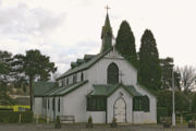
| Cyprus Road Tin Tabernacle | Faversham Faversham Faversham is a market town and civil parish in the Swale borough of Kent, England. The parish of Faversham grew up around an ancient sea port on Faversham Creek and was the birthplace of the explosives industry in England.-History:... , Kent Kent Kent is a county in southeast England, and is one of the home counties. It borders East Sussex, Surrey and Greater London and has a defined boundary with Essex in the middle of the Thames Estuary. The ceremonial county boundaries of Kent include the shire county of Kent and the unitary borough of... 51.3143°N 0.8973°W |
||
| Main Street Community Church | Frodsham Frodsham Frodsham is a market town and civil parish in the unitary authority of Cheshire West and Chester and the ceremonial county of Cheshire, England. Its population is 8,982. It is approximately south of Runcorn, 16 miles south of Liverpool, and approximately south-west of Manchester... , Cheshire Cheshire Cheshire is a ceremonial county in North West England. Cheshire's county town is the city of Chester, although its largest town is Warrington. Other major towns include Widnes, Congleton, Crewe, Ellesmere Port, Runcorn, Macclesfield, Winsford, Northwich, and Wilmslow... 53.2947°N 2.7291°W |
St Dunstan's Church cost £600 and opened with 230 seats in 1872 as a chapel of ease Chapel of ease A chapel of ease is a church building other than the parish church, built within the bounds of a parish for the attendance of those who cannot reach the parish church conveniently.... to the parish church. It was licenced as the parish church for two years from 1880 while St Laurence's Church St Laurence's Church, Frodsham St Laurence's Church, Frodsham is in Church Road, Frodsham, Cheshire, England. The church stands, not in the centre of the town, but in the elevated area of Overton overlooking the town. It has been designated by English Heritage as a Grade I listed building... was refurbished and retained as a mission church after that. After some years of disuse the building was taken over by the present evangelical congregation in the 1980s. The structure was moved on rollers ten feet to the left and refurbished in 1995 and acquired its current name in 2007. |
|
| Seventh Day Baptist Church | Greet Greet, Birmingham Greet is a historical area in south Birmingham, England, around modern Sparkhill.Now a name obsolete in addresses, Greet, meaning "gravel" ", was one of the medieval manors around Birmingham on the eastern gravelly slopes of the sandstone ridge which runs through central Birmingham... , Birmingham Birmingham Birmingham is a city and metropolitan borough in the West Midlands of England. It is the most populous British city outside the capital London, with a population of 1,036,900 , and lies at the heart of the West Midlands conurbation, the second most populous urban area in the United Kingdom with a... 52.4548°N 1.8573°W |
This is in active use as a Seventh Day Baptist Seventh Day Baptist Seventh Day Baptists are Christian Baptists who observe Sabbath on the seventh-day of the week in accord with their understanding of the Biblical Sabbath for the Judeo-Christian tradition... Church. |
|
| Evangelical Church | Haggerston Haggerston Haggerston is an area and a electoral ward in the London Borough of Hackney, in northeast London, UK. It is bounded by Hackney Road on the south, Kingsland Road on the west, Middleton Road on the north with London Fields and Broadway Market on the east... , Hackney London Borough of Hackney The London Borough of Hackney is a London borough of North/North East London, and forms part of inner London. The local authority is Hackney London Borough Council.... , London 51.5389°N 0.0650°W |
The church was built in 1868. Originally clad in corrugated iron, it has been re-clad in asbestos sheeting. It is described as "An early, rare and complete example of a temporary iron Mission Church", and is listed at Grade II. | |
| Halse Mission Church | Halse, Northamptonshire Northamptonshire Northamptonshire is a landlocked county in the English East Midlands, with a population of 629,676 as at the 2001 census. It has boundaries with the ceremonial counties of Warwickshire to the west, Leicestershire and Rutland to the north, Cambridgeshire to the east, Bedfordshire to the south-east,... 52.0586°N 1.1751°W |
Built in the late 19th century as a community room for railway workers, the building was bought by the Earl of Ellesmere Francis Egerton, 3rd Earl of Ellesmere Francis Charles Granville Egerton, 3rd Earl of Ellesmere VD, DL, JP , styled Viscount Brackley between 1857 and 1862, was a British peer, soldier and author... and moved to its present site. It opened for worship in 1900 and continues in use as a mission church in the parish of St Peter with St James, Brackley Brackley Brackley is a town in south Northamptonshire, England. It is about from Oxford and miles form Northampton. Historically a market town based on the wool and lace trade, it was built on the intersecting trade routes between London, Birmingham and the English Midlands and between Cambridge and Oxford... . |
|
| St Philip's Church | Hassall Green Hassall Green Hassall Green is a village in the civil parish of Betchton in the unitary authority of Cheshire East and the ceremonial county of Cheshire, England.... , Cheshire Cheshire Cheshire is a ceremonial county in North West England. Cheshire's county town is the city of Chester, although its largest town is Warrington. Other major towns include Widnes, Congleton, Crewe, Ellesmere Port, Runcorn, Macclesfield, Winsford, Northwich, and Wilmslow... 53.1208°N 2.3336°W |
This originated in 1883 as St Mary's Church, Alsager, and was moved to its present site at Hassall Green in 1895. It continues in use as an Anglican Anglicanism Anglicanism is a tradition within Christianity comprising churches with historical connections to the Church of England or similar beliefs, worship and church structures. The word Anglican originates in ecclesia anglicana, a medieval Latin phrase dating to at least 1246 that means the English... church in the benefice of Sandbach Heath with Wheelock. |
|
| Good Shepherd Mission | Hurlston Green, Scarisbrick Scarisbrick Scarisbrick is a village and civil parish in West Lancashire, England. It is spread out along the A570 so there is no real village centre, though the junction with the A5147 is close to the geographic centre... , Lancashire Lancashire Lancashire is a non-metropolitan county of historic origin in the North West of England. It takes its name from the city of Lancaster, and is sometimes known as the County of Lancaster. Although Lancaster is still considered to be the county town, Lancashire County Council is based in Preston... 53.5968°N 2.9090°W |
The mission was built in 1907, having been delivered via the Leeds and Liverpool Canal Leeds and Liverpool Canal The Leeds and Liverpool Canal is a canal in Northern England, linking the cities of Leeds and Liverpool. Over a distance of , it crosses the Pennines, and includes 91 locks on the main line... . It continues to be an active mission church in the parish of St Mark, Scarisbrick. |
|
| St Michael and All Angels' Church | Hythe Hythe, Kent Hythe , is a small coastal market town on the edge of Romney Marsh, in the District of Shepway on the south coast of Kent. The word Hythe or Hithe is an Old English word meaning Haven or Landing Place.... , Kent Kent Kent is a county in southeast England, and is one of the home counties. It borders East Sussex, Surrey and Greater London and has a defined boundary with Essex in the middle of the Thames Estuary. The ceremonial county boundaries of Kent include the shire county of Kent and the unitary borough of... 51.0698°N 1.0822°W |
St Michael and All Angels' Church is a Grade II listed building built in 1893. It is a pre-fabricated structure supplied by Humphrey's of Croydon. The exterior walls and roof are made of corrugated iron on a steel frame. The interior is boarded throughout and the church has wooden window frames. | |
| Kilburn tin tabernacle | Kilburn Kilburn Kilburn is an area of north west London, England, which is divided between three London Boroughs, Brent, Camden, and a small part in Westminster. The main thoroughfare running northwest-southeast is Kilburn High Road, part of the modern A5 road which forms the boundary between the boroughs of Brent... , London London London is the capital city of :England and the :United Kingdom, the largest metropolitan area in the United Kingdom, and the largest urban zone in the European Union by most measures. Located on the River Thames, London has been a major settlement for two millennia, its history going back to its... 51.5362°N 0.1923°W |
 |
This was built in 1862, and used for worship until the 1920s, when it was used by sea cadets. As of 2010 there is a campaign to repair and restore it. |
| St Fillan's Church | Killin Killin Killin is a village situated at the western head of Loch Tay in Stirling , Scotland.... , Stirling Stirling (council area) Stirling is one of the 32 unitary local government council areas of Scotland, and has a population of about 87,000 . It was created under the Local Government etc Act 1994 with the boundaries of the Stirling district of the former Central local government region, and it covers most of the former... , Scotland 56.4689°N 4.3168°W |
Built in 1876 by the Marquess of Breadalbane Gavin Campbell, 1st Marquess of Breadalbane Gavin Campbell, 1st Marquess of Breadalbane KG, PC, JP, DL , styled Lord Glenorchy between 1862 and 1871 and known as The Earl of Breadalbane and Holland between 1871 and 1885, was a Scottish nobleman and Liberal politician.-Background and education:Campbell was born at Fermoy, County Cork, the... for members of his shooting party, the church was extended in the early 20th century. It continues in active use in the Scottish Episcopal Church Scottish Episcopal Church The Scottish Episcopal Church is a Christian church in Scotland, consisting of seven dioceses. Since the 17th century, it has had an identity distinct from the presbyterian Church of Scotland.... . The building has been listed at Grade C(S). |
|
| Italian Chapel Italian Chapel The Italian Chapel is a highly ornate Catholic chapel on Lamb Holm in Orkney, Scotland. It was built by Italian prisoners of war during World War II, who were housed on the previously uninhabited island while they constructed the Churchill Barriers to the east of Scapa Flow. Only the concrete... |
Lamb Holm Lamb Holm Lamb Holm is a small uninhabited island in Orkney, Scotland. The remarkable Italian Chapel, constructed during the Second World War, is the island's main attraction.-Geography:... , Orkney, Scotland Scotland Scotland is a country that is part of the United Kingdom. Occupying the northern third of the island of Great Britain, it shares a border with England to the south and is bounded by the North Sea to the east, the Atlantic Ocean to the north and west, and the North Channel and Irish Sea to the... 58.8897°N 2.8901°W |
The Italian Chapel on the uninhabited island of Lamb Holm is a tin chapel made from corrugated iron from two Nissen hut Nissen hut A Nissen hut is a prefabricated steel structure made from a half-cylindrical skin of corrugated steel, a variant of which was used extensively during World War II.-Description:... s by Italian prisoners of war during World War II. |
|
| Tin tabernacle | Lenwade Lenwade Lenwade is a hamlet in the civil parish of Great Witchingham, Norfolk. Located in the Wensum Valley and adjacent to the A1067 road and being south-east of Fakenham and some north-west of Norwich.- Etymology:... , Norfolk Norfolk Norfolk is a low-lying county in the East of England. It has borders with Lincolnshire to the west, Cambridgeshire to the west and southwest and Suffolk to the south. Its northern and eastern boundaries are the North Sea coast and to the north-west the county is bordered by The Wash. The county... 52.721°N 1.108°W |
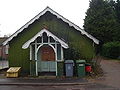 |
|
| St Peter's Church | Lower Withington Lower Withington Lower Withington is a civil parish and village in the unitary authority of Cheshire East and the ceremonial county of Cheshire, England. At the 2001 census, it had a total population of 492... , Cheshire Cheshire Cheshire is a ceremonial county in North West England. Cheshire's county town is the city of Chester, although its largest town is Warrington. Other major towns include Widnes, Congleton, Crewe, Ellesmere Port, Runcorn, Macclesfield, Winsford, Northwich, and Wilmslow... 53.2285°N 2.2915°W |
The church was built in 1891 as a chapel of ease Chapel of ease A chapel of ease is a church building other than the parish church, built within the bounds of a parish for the attendance of those who cannot reach the parish church conveniently.... to St John, Chelford St John the Evangelist's Church, Chelford St John the Evangelist's Church, Chelford lies to the southeast of the village of Chelford, Cheshire, England. The church has been designated by English Heritage as a Grade II* listed building. It is an active Anglican parish church in the diocese of Chester, the archdeaconry of Macclesfield... . The benefice of the two churches has been united. It is still in active use. |
|
| St Anne's Church | New Hedges, Pembrokeshire Pembrokeshire Pembrokeshire is a county in the south west of Wales. It borders Carmarthenshire to the east and Ceredigion to the north east. The county town is Haverfordwest where Pembrokeshire County Council is headquartered.... , Wales 51.6892°N 4.7087°W |
The church was built in 1928, and continues to be in active use in Tenby Benefice. | |
| St Mary's Church | Newton-by-the-Sea Newton-by-the-Sea Newton-by-the-Sea is a civil parish in the former district of Alnwick, Northumberland in Northern England.There are two distinct settlements High Newton-by-the-Sea and the coastal Low Newton-by-the-Sea, owned by the National Trust. The area is notable for the diversity of birds to be observed... , Northumberland Northumberland Northumberland is the northernmost ceremonial county and a unitary district in North East England. For Eurostat purposes Northumberland is a NUTS 3 region and is one of three boroughs or unitary districts that comprise the "Northumberland and Tyne and Wear" NUTS 2 region... 55.5172°N 1.6225°W |
The church was built as a mission room in the later part of the 19th century, and continues to be in active use as a church and a meeting room in the parish of Embleton Embleton, Northumberland Embleton village in the English county of Northumberland is about half-a-mile from the bay that carries its name. The sandy beach is backed by dunes where a variety of flowers bloom: bluebells, cowslips, burnet roses and, to give it its common name, bloody cranesbill, amongst others. Dunstanburgh... . |
|
| Congregational Chapel | Old Heath Old Heath Old Heath is a parish that is south-east of Colchester, Essex, England.Old Heath has existed since Saxon times and was originally called 'Old Hythe' because it was the first port of Colchester, before Hythe took over: hythe derives from the Old English word for 'landing place'.-Church:Old Heath... , Colchester Colchester Colchester is an historic town and the largest settlement within the borough of Colchester in Essex, England.At the time of the census in 2001, it had a population of 104,390. However, the population is rapidly increasing, and has been named as one of Britain's fastest growing towns. As the... , Essex Essex Essex is a ceremonial and non-metropolitan county in the East region of England, and one of the home counties. It is located to the northeast of Greater London. It borders with Cambridgeshire and Suffolk to the north, Hertfordshire to the west, Kent to the South and London to the south west... 51.8684°N 0.9282°W |
The chapel was built in 1869 as an outreach mission for Lion Walk Congregational Church. It was enlarged in 1888, and again in 1898. It continues in use as a Congregational chapel. | |
| Tin tabernacle | Pensarn Pensarn Pensarn is a suburb of Abergele in Conwy County Borough, Wales. It has a population of around 2,000.The name Pensarn means 'end of the causeway' in English. The crossing of Morfa Rhuddlan was facilitated by a causeway near the sea, located at this point... , Abergele Abergele Abergele is a community and old Roman trading town, situated on the north coast of Wales between the holiday resorts of Colwyn Bay and Rhyl, in Conwy County Borough. Its northern suburb of Pensarn lies on the Irish Sea coast and is known for its beach, where it is claimed by some that a ghost ship... , Conwy, Wales 53.2938°N 3.5797°W |
||
| Heath Church | Reigate Reigate Reigate is a historic market town in Surrey, England, at the foot of the North Downs, and in the London commuter belt. It is one of the main constituents of the Borough of Reigate and Banstead... , Surrey Surrey Surrey is a county in the South East of England and is one of the Home Counties. The county borders Greater London, Kent, East Sussex, West Sussex, Hampshire and Berkshire. The historic county town is Guildford. Surrey County Council sits at Kingston upon Thames, although this has been part of... 51.2380°N 0.2242°W |
The first service was held in 1907, and the church continues in use in the parish of St Mary Magdalene, Reigate. | |
| Methodist Chapel | Rhosnensi, Wrexham, Wales 53.0560°N 2.9746°W |
In active use as a Methodist chapel. | |
| Calvary Evangelical Church | Rhymney Rhymney Rhymney is a town and a community located in the county borough of Caerphilly in south-east Wales, within the historic boundaries of Monmouthshire. Along with the villages of Pontlottyn, Fochriw, Abertysswg, Deri and New Tredegar, Rhymney is designated as the 'Upper Rhymney Valley' by the local... , Caerphilly, Wales 51.7596°N 3.2828°W |
The building continues in use as an evangelical Evangelicalism Evangelicalism is a Protestant Christian movement which began in Great Britain in the 1730s and gained popularity in the United States during the series of Great Awakenings of the 18th and 19th century.Its key commitments are:... church. |
|
| Cuxton Chapel, Kent Life |
Sandling Sandling, Maidstone Sandling is a suburb to the north of the town of Maidstone, Kent, England. Within the area is the headquarters of the Kent Wildlife Trust at Tyland Barn. Beside the River Medway is an eating place called The Malta Inn. Sandling is also home to the Museum of Kent Life... , Kent Kent Kent is a county in southeast England, and is one of the home counties. It borders East Sussex, Surrey and Greater London and has a defined boundary with Essex in the middle of the Thames Estuary. The ceremonial county boundaries of Kent include the shire county of Kent and the unitary borough of... 51.2976°N 0.5049°W |
Originally a chapel in the village of Cuxton Cuxton Cuxton is a village in the unitary authority of Medway. It lies on left bank of the River Medway in the North Downs. It is served by the A228, and Cuxton railway station on the Medway Valley Line between Strood and Maidstone... , Kent, it was moved to the museum Kent Life in 2000. |
|
| St Mary's Church Room | Sole Street, Cobham Cobham, Kent Cobham is a village and civil parish in the Gravesham District of Kent, England. It is located south of Watling Street, the old road from Dover to London, six miles south-east of Gravesend. The hamlet of Sole Street lies within the parish, which covers an area of 1,240 ha and has a population of... , Kent Kent Kent is a county in southeast England, and is one of the home counties. It borders East Sussex, Surrey and Greater London and has a defined boundary with Essex in the middle of the Thames Estuary. The ceremonial county boundaries of Kent include the shire county of Kent and the unitary borough of... 51.3836°N 0.3794°W |
The building continues to be in use as part of the parish of St Mary Magdalene, Cobham. | |
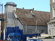
| Great Moulton Chapel, Museum of East Anglian Life Museum of East Anglian Life The Museum of East Anglian Life is a Museum located in Stowmarket Suffolk, it specialises in presenting the agricultural history of East Anglia through a mixture of exhibits and living history demonstrations. It has recently taken to abbreviating itself as 'MEAL'.-History of the Museum:The site of... |
Stowmarket Stowmarket -See also:* Stowmarket Town F.C.* Stowmarket High School-External links:* * * * *... , Suffolk Suffolk Suffolk is a non-metropolitan county of historic origin in East Anglia, England. It has borders with Norfolk to the north, Cambridgeshire to the west and Essex to the south. The North Sea lies to the east... 52.1829°N 0.9928°W |
This was a non-denominational chapel, and had strong ties with other chapels, including Surrey Chapel Surrey Chapel The Surrey Chapel was an independent Methodist and Congregational church established in Blackfriars Road, Southwark, London on 8 June 1783 by the Rev. Rowland Hill. His work was continued in 1833 by the Congregational pastor Rev. James Sherman, and in 1854 by Rev. Newman Hall. The chapel's design... . It was built in the 1890s by the Norwich Norwich Norwich is a city in England. It is the regional administrative centre and county town of Norfolk. During the 11th century, Norwich was the largest city in England after London, and one of the most important places in the kingdom... firm of Boulton and Paul Boulton & Paul Ltd Boulton & Paul was a British general manufacturer from Norwich that became involved in aircraft manufacture.Jeld Wen Inc, bought Boulton & Paul Boulton & Paul was a British general manufacturer from Norwich that became involved in aircraft manufacture.Jeld Wen Inc, bought Boulton & Paul Boulton &... at a cost of £105 18s Shilling The shilling is a unit of currency used in some current and former British Commonwealth countries. The word shilling comes from scilling, an accounting term that dates back to Anglo-Saxon times where it was deemed to be the value of a cow in Kent or a sheep elsewhere. The word is thought to derive... 0d Penny A penny is a coin or a type of currency used in several English-speaking countries. It is often the smallest denomination within a currency system.-Etymology:... . The chapel closed in 1990 and was moved the 30 miles (48 km) from Great Moulton Great Moulton Great Moulton is a civil parish in the English county of Norfolk.It covers an area of and had a population of 699 in 289 households as of the 2001 census.For the purposes of local government, it falls within the district of South Norfolk.... to the museum. |
|
| St Paul's Church | Strines, Marple Marple, Greater Manchester Marple is a small town within the Metropolitan Borough of Stockport, in Greater Manchester, England. It lies on the River Goyt southeast of Stockport.Historically part of Cheshire, Marple has a population of 23,480 .-Toponymy:... , Greater Manchester Greater Manchester Greater Manchester is a metropolitan county in North West England, with a population of 2.6 million. It encompasses one of the largest metropolitan areas in the United Kingdom and comprises ten metropolitan boroughs: Bolton, Bury, Oldham, Rochdale, Stockport, Tameside, Trafford, Wigan, and the... 53.3747°N 2.0432°W |
St Paul's is located 1.5 miles (2.4 km) southeast of Marple Marple, Greater Manchester Marple is a small town within the Metropolitan Borough of Stockport, in Greater Manchester, England. It lies on the River Goyt southeast of Stockport.Historically part of Cheshire, Marple has a population of 23,480 .-Toponymy:... , Greater Manchester Greater Manchester Greater Manchester is a metropolitan county in North West England, with a population of 2.6 million. It encompasses one of the largest metropolitan areas in the United Kingdom and comprises ten metropolitan boroughs: Bolton, Bury, Oldham, Rochdale, Stockport, Tameside, Trafford, Wigan, and the... in the parish of All Saints, Marple All Saints Church, Marple All Saints Church, Marple, is in the town of Marple, Greater Manchester, England. It has been designated by English Heritage as a Grade II listed building. In the churchyard is the tower of an earlier church. This is also listed Grade II... . It was built in 1880 by the owners of Strines (Calico) Print Works. The church continues in active use, and in November 2011 was designated by English Heritage English Heritage English Heritage . is an executive non-departmental public body of the British Government sponsored by the Department for Culture, Media and Sport... as a Grade II listed building. |
|
| St Saviour's Church, Midland Railway Centre |
Swanwick Junction Swanwick Junction railway station Swanwick Junction railway station is a heritage railway station situated on the former Ambergate to Pye Bridge Line which closed in 1968, but has been partially reopened by the Midland Railway - Butterley. Despite the station's name it is some distance from Swanwick.There was originally no station... , Derbyshire Derbyshire Derbyshire is a county in the East Midlands of England. A substantial portion of the Peak District National Park lies within Derbyshire. The northern part of Derbyshire overlaps with the Pennines, a famous chain of hills and mountains. The county contains within its boundary of approx... 53.0617°N 1.3829°W |
St Saviour's Church, originally located at Westhouses Westhouses Westhouses is a village within Derbyshire, situated close to the town of Alfreton. It is in the Bolsover district of the county. Named after West House Farm, the settlement was founded in the 1870s.- Railway :... , Nottinghamshire, was dismantled and rebuilt at Swanwick Junction by the Midland Railway Trust. The church was originally consecrated in 1898, became redundant in the 1990s and was acquired for the museum site. |
|
| Syre Church | Syre Syre, Scotland Syre is a small settlement, located within Strath Naver, in Sutherland, Scottish Highlands and is in the Scottish council area of Highland.... , Strathnaver Strathnaver Strathnaver or Strath Naver is the fertile strath of the River Naver, a famous salmon river that flows from Loch Naver to the north coast of Scotland... , Scotland 58.3639°N 4.2375°W |
||
| Thorlby Chapel | Thorlby Stirton with Thorlby Stirton with Thorlby is a civil parish in the Craven district of North Yorkshire, England.... , North Yorkshire North Yorkshire North Yorkshire is a non-metropolitan or shire county located in the Yorkshire and the Humber region of England, and a ceremonial county primarily in that region but partly in North East England. Created in 1974 by the Local Government Act 1972 it covers an area of , making it the largest... 53.9716°N 2.0527°W |
Abandoned building | |
| All Saints Church | Thrupp, Gloucestershire Gloucestershire Gloucestershire is a county in South West England. The county comprises part of the Cotswold Hills, part of the flat fertile valley of the River Severn, and the entire Forest of Dean.... 51.7267°N 2.2015°W |
The church was established in 1889, dedicated to All Saints, and was part of the parish of Holy Trinity, Stroud Stroud Stroud a town and civil parish in the county of Gloucestershire, England.Stroud may also refer to:*Stroud, New South Wales, Australia*Stroud, Ontario, Canada*Stroud , Gloucestershire, UK*Stroud... . It closed in 1968, some of its fittings were moved to Holy Trinity, and there were plans for it to be dismantled and stored. The photograph shows the building in 2002. |
|
| St Antony of Padua Roman Catholic Church | Trafford Park Village, Greater Manchester Greater Manchester Greater Manchester is a metropolitan county in North West England, with a population of 2.6 million. It encompasses one of the largest metropolitan areas in the United Kingdom and comprises ten metropolitan boroughs: Bolton, Bury, Oldham, Rochdale, Stockport, Tameside, Trafford, Wigan, and the... 53.9621°N 1.8855°W |
Three tin tabernacles were built in Trafford Park Village: a Methodist chapel in 1901, the Anglican St Cuthbert's Church in 1902, and the Roman Catholic St Antony of Padua in 1904. Much of the village was demolished by the early 1980s leaving the church with no resident population. Its parish became an industrial chaplaincy. The church closed in 2009 but the building was retained for use by the Centre for Church and Industry. | |
| St Paul's Mission Church | Warren Row Warren Row Warren Row is a village in Berkshire, England, and part of the civil parish of Hurley.The settlement lies between the A321 A4 and A4130 roads, and is located approximately south-east of Henley-on-Thames.... , Berkshire Berkshire Berkshire is a historic county in the South of England. It is also often referred to as the Royal County of Berkshire because of the presence of the royal residence of Windsor Castle in the county; this usage, which dates to the 19th century at least, was recognised by the Queen in 1957, and... 51.5194°N 0.8309°W |
The church was bought as a kit in 1894 for just over £100. It continues in active use as a mission church in the parish of Wargrave Wargrave Wargrave is a large village and civil parish in the English county of Berkshire, which encloses the confluence of the River Loddon and the River Thames. It is in the Borough of Wokingham... . |
|
| St Andrew's Mission Church | Wern, Minera Minera Minera is a small village, and a local government community, the lowest tier of local government, part of Wrexham County Borough in Wales.The community, which in addition to Minera village includes a number of smaller hamlets such as Gwynfryn and New Brighton and large areas of farmland, had a... , Wrexham Wrexham Wrexham is a town in Wales. It is the administrative centre of the wider Wrexham County Borough, and the largest town in North Wales, located in the east of the region. It is situated between the Welsh mountains and the lower Dee Valley close to the border with Cheshire, England... , Wales 53.0446°N 3.0761°W |
||
| Church of St Francis | Westhope, Canon Pyon Canon Pyon Canon Pyon is a village on the A4110 road in Herefordshire, England.The name derives from the nearby Pyon Hill. 'Pyon', is unusual and is not used anywhere else in Britain, with the exception of the nearby village of Kings Pyon, on the other side of the hill.... , Herefordshire Herefordshire Herefordshire is a historic and ceremonial county in the West Midlands region of England. For Eurostat purposes it is a NUTS 3 region and is one of three counties that comprise the "Herefordshire, Worcestershire and Gloucestershire" NUTS 2 region. It also forms a unitary district known as the... 52.1551°N 2.7850°W |
The building continues to be in use as a Anglican Anglicanism Anglicanism is a tradition within Christianity comprising churches with historical connections to the Church of England or similar beliefs, worship and church structures. The word Anglican originates in ecclesia anglicana, a medieval Latin phrase dating to at least 1246 that means the English... mission church in the parish of St Lawrence, Canon Pyon. |
|
| Winterslow Baptist Church | Winterslow Winterslow Winterslow is a village with a population of around 2,000 people, located about 6 miles North East of Salisbury, Wiltshire, United Kingdom, just off the A30 London Road. It has a primary school, a pre-school group, a village shop and post office, doctor's surgery, two pubs, 5 churches, a large... , Wiltshire Wiltshire Wiltshire is a ceremonial county in South West England. It is landlocked and borders the counties of Dorset, Somerset, Hampshire, Gloucestershire, Oxfordshire and Berkshire. It contains the unitary authority of Swindon and covers... 51.0876°N 1.6661°W |
In active use as a Baptist church. | |
Examples elsewhere
| Name | Location | Photograph | Notes |
|---|---|---|---|
| Wesleyan Church | Adelaide Adelaide Adelaide is the capital city of South Australia and the fifth-largest city in Australia. Adelaide has an estimated population of more than 1.2 million... , South Australia South Australia South Australia is a state of Australia in the southern central part of the country. It covers some of the most arid parts of the continent; with a total land area of , it is the fourth largest of Australia's six states and two territories.South Australia shares borders with all of the mainland... |
 |
The Wesleyan church in Adelaide Adelaide Adelaide is the capital city of South Australia and the fifth-largest city in Australia. Adelaide has an estimated population of more than 1.2 million... , South Australia South Australia South Australia is a state of Australia in the southern central part of the country. It covers some of the most arid parts of the continent; with a total land area of , it is the fourth largest of Australia's six states and two territories.South Australia shares borders with all of the mainland... has been renovated. It was shipped to Darwin Darwin, Northern Territory Darwin is the capital city of the Northern Territory, Australia. Situated on the Timor Sea, Darwin has a population of 127,500, making it by far the largest and most populated city in the sparsely populated Northern Territory, but the least populous of all Australia's capital cities... , Northern Territory Northern Territory The Northern Territory is a federal territory of Australia, occupying much of the centre of the mainland continent, as well as the central northern regions... in 1897 and subsequently moved to its current location. |