

The Amazing Race en Discovery Channel 1
Encyclopedia
The Amazing Race en Discovery Channel 1 (English
: The Amazing Race on Discovery Channel) is a reality television
game show
of The Amazing Race en Discovery Channel
. The show featured eleven teams of two, with a pre-existing relationship, in a race across Latin America to win US$
250,000. The race was produced by RGB Entertainment. The host of the show is Harris Whitbeck
.
The applications were accepted from November 17, 2008 to January 31, 2009.
The Amazing Race en Discovery Channel premiered on Sunday, September 20, 2009 at 10:00 p.m.(UTC-5
). The season finale was aired on December 13, 2009 at 10:00 p.m. (UTC-5
).
The route markers in this season were colored blue
and black
, including the clue envelopes and the Pit Stop. Also different from other editions is the fact that the opening shows the teams' country of origin.
Argentine Married Couple Matías Franchini & Tamara Reichelt are the winners of the race.
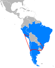
The Detour in this leg was Flores o Árbol ("Flowers or Tree"). In Flores, teams made their way to Lago Negro. Once there, teams had to take a swan boat out and paddle to the other shore to pick up a basket of flowers from a villager. Then they had to go back to the dock and give the basket to a female villager to receive their next clue. In Árbol, teams made their way to the Aldeia Do Papai Noel. Once in the village, teams searched in the "Arvore dos desejos" for a "Mimo" with their names written on it, which they had to give to a Goblin in order to receive their next clue.
Additional tasks
In the Roadblock, one team member had to search a bag with a goalkeeper's clothing inside; once wearing the clothing, the person had to defend a penalty kick. If they didn't defend a penalty kick in 5 minutes, they had to let another team try to complete the task. In the Speed Bump, Ariel & Nora had to take a van and deliver 5 packs of papers to some newsstands. The Detour was a choice between Caballos o Caballerizas ("Horses or Stables"). In Caballos, teams had to ride by horse in the Arena and pick up two
flags; once they gave the flags to the handler, they received their next clue. In Caballerizas, teams had to clean a stable completely and take the mess in a wheelbarrow to the fertilizer's reservoir; when completed, the handler gave them their next clue.
Additional tasks
) to Mendoza
(Francisco Gabrielli International Airport
)
In the Fast Forward, teams had to make their way to Monumento al Ejército de los Andes . Once there, they had to put in order 1,000 toy soldiers and make 25 rows with 40 soldiers in each; once completed, that team would win the Fast Forward. In the Roadblock, one team member had to search in a vineyard for a box with wine bottles inside. They had to take 18 bottles, label them, and put in their boxes; when finished, they would receive their next clue. The Detour was a choice between Aire o Piedra ("Air or Stone"). In Aire teams had to do a zipline. In Piedra teams received a stone with a copy of a rock drawing, then had to search for that drawing on the hill and show it to the Shaman to receive their next clue.
Additional tasks
In the Roadblock, one team member had to jump from a platform into the Pacific Ocean. Then, he or she had to swim 30 meters below the platform; once finished, the instructor would give them the next clue. The Detour was a choice between Mariscos o Carnada ("Seafood or Bait"). In Mariscos, teams had to eat an entire plate of "Mariscal Frio"; once finished, they would receive the next clue. In Carnada, teams had to place bait onto 100 fish hooks; once finished, they would receive their next clue.
Additional tasks

In the Roadblock, one team member had to make a big bubble, drive a robot and transport two stones, then in a Gyroscope
they had to read out loud a famous phrase; once finished the instructor gave them their next clue. The Detour in this leg was Dulce o Salado ("Sweet or Salted"). In Dulce, teams had to buy a packet of good luck cookies and look for a cookie with a message inside; then they had to find that message in the sidewalk quarries. When they found it, they had to show it to the Chinese master to receive their next clue. In Salado, teams had to go to a Chinese-Peruvian restaurant called 'Chifa
' and cut two ducks, hack 6 pounds of onion and ten heads of garlic, following an exotic recipe; once finished, the cook gave the next clue.
Additional tasks
(Alejandro Velasco Astete International Airport
)
In this Leg's Roadblock, one team member had to jump off the highest Bungee Jump in South America. The Detour in this leg was Hojas o Granos ("Leaves or Grains"). In Hojas, teams had to search for three coca leaves among many different leaves; once found, they had to give them to the Master Healer to receive the next clue. In Granos, teams had to transport 100 maize cobs to a large course, once completed the Cacique gave the next clue.
Additional tasks
, Colombia
 (El Dorado International Airport
)
In this Roadblock, one team member had to rappel down a waterfall to receive the next clue. The Detour in this leg was Visual o Táctil ("Visual or Tactile"). In Visual, teams had 15 seconds to observe a Fernando Botero
painting in Virgilio Barco Public Library, then fill in another painting with some colors missing; when judged correct, they received the next clue. In Táctil, teams had to receive a chocolate massage; when finished with the massage, they received the next clue. In the Speed Bump, Casilda & Casilda had to perform a Colombian Tejo
to receive the next clue.
Additional tasks
The Detour in this leg was Hacia Adelante o Hacia Arriba ("Onward or Upward"). In Hacia Adelante, teams had to go to Baluarte Santo Domingo and pick 12 baskets, then take them to Baluarte San Pedro Mártir and give them to a man who would give them the next clue. In Hacia Arriba, teams had to climb up a ship's mast, take two flags, and give them to the captain in order to receive the next clue. In the Roadblock, a team member had to eat a bottle of local candies to received the next clue.
Additional tasks
, Panama
 (Tocumen International Airport
)
The Detour for this leg was Pasacables o Timonel ("Cableman or Helmsman"). In Pasacables, teams had to go to the Miraflores Locks Visitor Center, then pass a cable above a metal rod high above them. After passing three cables above the rod (with 6 shots per turn), a cableman would give them the next clue. In Timonel, teams had to go to Sidmar (Marine Training School) and sail a boat in a simulator of the Panama Canal without crashing into any other boat. If they sailed safely for 15 minutes, the captain would give them their next clue. In the Roadblock, at the Cargo Terminal of the Pacific, a team member had to look among 60 freight wagons for the only lamp which could be turned on; once it was found, they received the next clue.
Additional tasks
 Panama City (Tocumen International Airport) to Santo Domingo, Dominican Republic
 (Las Americas International Airport
)
In the Roadblock, a team member had to hit a professional pitcher
's throw to receive the next clue. The Detour was a choice between Ofrenda o Astucia ("Offering or Cunning"). In Ofrenda, teams had to search for a small statuette inside a cave and take it to a big statuette in another place in the cave; once they put them together properly, they would receive the next clue. In Astucia, teams had to form a square from pieces of a tangram
; when finished, they would receive the next clue.
Additional tasks
, Costa Rica
 (Juan Santamaría International Airport
) to Quepos
(Quepos Managua Airport
)
In the Roadblock, a team member had to choose a site, dig to get a chest with keys inside, then search for another chest and try to open it with one of the keys they found. The clue was inside one of the chests, but there were many empty chests buried. The Detour was Palas o Remos ("Shovels or Paddles"). In Palas, teams had to create the picture of a seahorse
in the sand, following an example exactly. When they had completed this correctly, the sculptor would give them their next clue. In Remos, teams had to row a kayak
to a boat in the sea, where a sailor would give them their next clue. In the Speed Bump, Matías & Tamara went to the Manuel Antonio Hotel, where they had to clean six hotel rooms; once completed, the chamberlain gave them their next clue.
Additional tasks
, Quintana Roo
, Mexico
 (Cancún International Airport
)
In this leg's first Roadblock, one team member had to eat 3 Mexican tacos
with grasshopper
s, Maguey Worm
and several species of cricket
to receive the next clue. This leg's first Detour was a choice between Altura o Profundidad ("Height or Deepness"). In Altura, teams had 3 minutes to climb a greasy pole
; each team member had to reach one flag on the top of the pole. Once they had collected two flags, they would receive the next clue. In Profundidad, teams had 3 minutes to dive into a shark tank, where each team member had to find a marked stone
on the bottom of the tank; once they had collected the two marked stones, they would receive the next clue.
In the leg's second Roadblock, one team member had to take a flag from one wrestler's boot in three minutes, while three wrestlers were fighting with him/her. In the leg's second Detour was Mariachi
s o Trajineras . In Mariachis, teams had to find an image of Santa Muerte
under a hat worn by one of the mariachis playing. In Trajineras, teams had to find a trajinera (typical boats of Xochimilco) called "Zita" and find the clue inside the boat.
Additional tasks
English language
English is a West Germanic language that arose in the Anglo-Saxon kingdoms of England and spread into what was to become south-east Scotland under the influence of the Anglian medieval kingdom of Northumbria...
: The Amazing Race on Discovery Channel) is a reality television
Reality television
Reality television is a genre of television programming that presents purportedly unscripted dramatic or humorous situations, documents actual events, and usually features ordinary people instead of professional actors, sometimes in a contest or other situation where a prize is awarded...
game show
Game show
A game show is a type of radio or television program in which members of the public, television personalities or celebrities, sometimes as part of a team, play a game which involves answering questions or solving puzzles usually for money and/or prizes...
of The Amazing Race en Discovery Channel
The Amazing Race en Discovery Channel
The Amazing Race Latinoamérica, previously known as The Amazing Race en Discovery Channel, is a reality game show based on the American series, The Amazing Race....
. The show featured eleven teams of two, with a pre-existing relationship, in a race across Latin America to win US$
United States dollar
The United States dollar , also referred to as the American dollar, is the official currency of the United States of America. It is divided into 100 smaller units called cents or pennies....
250,000. The race was produced by RGB Entertainment. The host of the show is Harris Whitbeck
Harris Whitbeck
Harris Whitbeck is CNN's International Correspondent based in Mexico City, Mexico. He covers key events in Latin America and around the world for CNN Worldwide, including CNN International, CNN en Español, and CNN/U.S....
.
The applications were accepted from November 17, 2008 to January 31, 2009.
The Amazing Race en Discovery Channel premiered on Sunday, September 20, 2009 at 10:00 p.m.(UTC-5
UTC-5
UTC−05:00 is an identifier for a time offset from UTC of −05.This offset is used in the Eastern Time Zone during standard time and in the Central Time Zone during Daylight Saving Time ....
). The season finale was aired on December 13, 2009 at 10:00 p.m. (UTC-5
UTC-5
UTC−05:00 is an identifier for a time offset from UTC of −05.This offset is used in the Eastern Time Zone during standard time and in the Central Time Zone during Daylight Saving Time ....
).
The route markers in this season were colored blue
Blue
Blue is a colour, the perception of which is evoked by light having a spectrum dominated by energy with a wavelength of roughly 440–490 nm. It is considered one of the additive primary colours. On the HSV Colour Wheel, the complement of blue is yellow; that is, a colour corresponding to an equal...
and black
Black
Black is the color of objects that do not emit or reflect light in any part of the visible spectrum; they absorb all such frequencies of light...
, including the clue envelopes and the Pit Stop. Also different from other editions is the fact that the opening shows the teams' country of origin.
Argentine Married Couple Matías Franchini & Tamara Reichelt are the winners of the race.
Results
The following teams participated in the Race, with their relationships at the time of filming. Placements are listed in finishing order:| Team | Relationship | Position (by leg) | Roadblocks performed |
||||||||||||
|---|---|---|---|---|---|---|---|---|---|---|---|---|---|---|---|
| 1 | 2 | 3 | 4 | 5 | 6 | 7 | 8 | 9 | 11 | 12 | |||||
 Matías & Tamara Matías & Tamara |
Married | 1st | 1st | 2nd | 2nd | 2nd | 3rd | 1st | 2nd | 4th | 3rd | 3rd | 1st | Matías 6, Tamara 5 | |
 Daniel & David Daniel & David |
2nd | 10th | 3rd | 1st | 3rd | 6th | 4th | 3rd | 3rd | 2nd | 2nd | 1st | 2nd | Daniel 6, David 6 | |
 Ferna & Fran Ferna & Fran |
Friends | 10th | 3rd | 8th | 5th | 5th | 1st | 2nd | 1st | 2nd | 1st | 1st | 2nd | 3rd | Ferna 6, Fran 6 |
 Daniel & Carlos Daniel & Carlos |
Friends | 5th | 2nd | 7th | 4th | 4th | 2nd | 5th | 5th | 1st | 2nd | Daniel 5, Carlos 5 | |||
| Rodrigo & Anna |
Dating Biologists | 6th | 8th | 4th | 6th | 1st | 4th | 3rd | 4th | Rodrigo 4, Anna 4 | |||||
| Casilda & Casilda |
Mother/Daughter | 3rd | 6th | 1st | 3rd | 6th | 6th | ||||||||
| Diego & Miguel |
Boyfriends | 7th | 5th | 5th | 8th | 7th | 5th | Diego 2, Miguel 4 | |||||||
| Mario & Melissa |
Dating | 8th | 4th | 9th | 7th | Mario 3, Melissa 1 | |||||||||
| Ricardo & Adriana |
Father/Daughter | 4th | 9th | 6th | Ricardo 1, Adriana 2 | ||||||||||
| Twins | 9th | 7th | Guillermo 1, Gabriel 1 | ||||||||||||
| Nora & Ariel |
Siblings | Nora 0, Ariel 1 | |||||||||||||
- A team placement indicates that the team was eliminated.
- A and team placement indicates that the team won a Fast Forward clue.
- An team placement indicates that the team came in last on a non-elimination leg and had to perform a Speed Bump in the next leg of the race.
- A indicates that the team chose to use the Yield; indicates the team who received it; around a leg number indicates that the Yield for that leg was available but not used.
- A indicates that the team chose to use a U-Turn; indicates the team who received it.
- Italicized results indicate the position of the team at the mid-point of a two-episode leg.
- Ariel & Nora initially arrived 3rd, but they received a 4-hour penalty for refusing to complete the Speed Bump, dropping their placement to 11th (last place), which resulted them eliminated.
- ^ Diego & Miguel and Mario & Melissa received 1-hour penalty each team for not completing an additional task. Since neither placements were affected, Diego & Miguel were able to check in as 7th and the start of the penalty time would instead be accessed in the next leg, and Mario & Mellisa were eliminated without issuing the penalty.
- Casilda & Casilda arrived 2nd, but received 1-hour penalty for doing the option not chosen by them on the Detour. All the other teams checked in during the penalty hour, dropping their placement to last; however they were notified as a non-elimination leg, thus the remaining penalty time would be accessed at the start of the next leg.
- Casilda & Casilda didn't complete the Roadblock. Already in last place, they were eliminated immediately without correcting the roadblock or accessed the 4-hour penalty.
- On Leg 10, Daniel & David and Daniel & Carlos arrived at the same time at the pit stop, both tied in 2nd place.
- Leg 12 was a double-length leg with two Detours and two Roadblocks and was shown over two episodes. In the first half, Daniel & David arrived first at the mid-point (and even not being a real pit stop (or finish line)) and they won prizes.
Prizes
The prize for each leg is awarded to the first place team for that leg.- Leg 1 – $200 Credit Card issued by Visa for each team member.
- Leg 2 – $200 Credit Card issued by Visa for each team member.
- Leg 3 – $300 Credit Card issued by Visa for each team member.
- Leg 4 – $300 Credit Card issued by Visa and a Nintendo DSiNintendo DSiThe is a handheld game system created by Nintendo and launched in 2008 and 2009 in Japan, North America, PAL territories, and other regions. It is the third iteration of the Nintendo DS, and its primary market rival is Sony's PlayStation Portable...
for each team member. - Leg 5 – $300 Credit Card issued by Visa and a WiiWiiThe Wii is a home video game console released by Nintendo on November 19, 2006. As a seventh-generation console, the Wii primarily competes with Microsoft's Xbox 360 and Sony's PlayStation 3. Nintendo states that its console targets a broader demographic than that of the two others...
for each team member. - Leg 6 – $400 Credit Card issued by Visa and a Palm Treo ProPalm Treo ProThe Palm Treo Pro is a combination PDA/cell phone offered in both GSM and CDMA. It is Palm's fourth Windows Mobile Treo. It replaced the short-lived Sprint Treo 800w.- Specifications :The phone originally was released in an unlocked GSM format...
for each team member. - Leg 7 – $400 Credit Card issued by Visa and a Wii for each team member.
- Leg 8 – $500 Credit Card issued by Visa and a Palm Treo Pro for each team member.
- Leg 9 – $600 Credit Card issued by Visa and a Nintendo DSi for each team member.
- Leg 10 – $800 Credit Card issued by Visa and a Palm Treo Pro for each team member.
- Leg 11 – $1000 Credit Card issued by Visa and a Palm Treo Pro for each team member and a stay of 7 nights at The Fairmont Mayakoba Hotel & Spa located at the Riviera MayaRiviera MayaRiviera Maya, also known as the Mayan Riviera, is a tourism district following the coastal Highway 307 which parallels the Caribbean coastline of the Mexican state of Quintana Roo, located on the eastern portion of the Yucatán Peninsula...
, MexicoMexicoThe United Mexican States , commonly known as Mexico , is a federal constitutional republic in North America. It is bordered on the north by the United States; on the south and west by the Pacific Ocean; on the southeast by Guatemala, Belize, and the Caribbean Sea; and on the east by the Gulf of...
with a spaSpaThe term spa is associated with water treatment which is also known as balneotherapy. Spa towns or spa resorts typically offer various health treatments. The belief in the curative powers of mineral waters goes back to prehistoric times. Such practices have been popular worldwide, but are...
treatment. - Leg 12.1 – 2 tickets courtesy of Mexicana AirlinesMexicana de AviaciónFounded in 1921, Compañía Mexicana de Aviación, S.A. de C.V. was Mexico's oldest airline, before ceasing operations on August 28, 2010. The group's closure was announced by the company's recently installed management team a short time after the group filed for Concurso Mercantil and US Chapter 15...
, 7 nights in the State of YucatánYucatánYucatán officially Estado Libre y Soberano de Yucatán is one of the 31 states which, with the Federal District, comprise the 32 Federal Entities of Mexico. It is divided in 106 municipalities and its capital city is Mérida....
(2 Nights at Hotel Mayaland Resort, Chichen ItzaChichen ItzaChichen Itza is a large pre-Columbian archaeological site built by the Maya civilization located in the northern center of the Yucatán Peninsula, in the Municipality of Tinúm, Yucatán state, present-day Mexico....
+ 3 nights at the Hacienda Xcanatún, MéridaMérida, YucatánMérida is the capital and largest city of the Mexican state of Yucatán and the Yucatán Peninsula. It is located in the northwest part of the state, about from the Gulf of Mexico coast...
+ 2 nights at Hotel Lodge Uxmal, UxmalUxmalUxmal was dominant from 875 to 900 CE. The site appears to have been the capital of a regional state in the Puuc region from 850-950 CE. The Maya dynasty expanded their dominion over their neighbors. This prominence didn't last long...
). - Leg 12.2 – $250,000
Race summary
Leg 1 (Brazil)
- Foz do IguaçuFoz do IguaçuFoz do Iguaçu is the 7th largest city in Paraná state, Brazil, with a population of 255,900 inhabitants. It is located approximately 650 km west of Curitiba, Parana's capital city, being the westernmost city in that state...
, ParanáParaná (state)Paraná is one of the states of Brazil, located in the South of the country, bordered on the north by São Paulo state, on the east by the Atlantic Ocean, on the south by Santa Catarina state and the Misiones Province of Argentina, and on the west by Mato Grosso do Sul and the republic of Paraguay,...
, BrazilBrazilBrazil , officially the Federative Republic of Brazil , is the largest country in South America. It is the world's fifth largest country, both by geographical area and by population with over 192 million people...
(Parque Nacional do IguaçuIguaçu National ParkIguaçu National Park is a national park in Paraná State, Brazil.Created by federal decree nr. 1035 of January 10, 1939, the Park comprises a total area of 185,262.5 hectares and a length of about 420km, 300km of which are natural borders by bodies of water and the Brazilian and Argentinean sides...
– Mirante Garganta do Diabo) (Starting Line) - Foz do Iguaçu (Parque Nacional do Iguaçu – Garganta do Diabo Falls )
- Foz do Iguaçu (Parque Nacional do Iguaçu – Cânion Iguaçu) Foz do Iguaçu (Foz do Iguaçu International AirportFoz do Iguaçu International AirportFoz do Iguaçu/Cataratas International Airport , is the airport serving Foz do Iguaçu, Brazil. It is named after the Iguazu Falls .It is operated by Infraero.-Airlines and destinations:-Accidents and incidents:...
) to Porto AlegrePorto AlegrePorto Alegre is the tenth most populous municipality in Brazil, with 1,409,939 inhabitants, and the centre of Brazil's fourth largest metropolitan area . It is also the capital city of the southernmost Brazilian state of Rio Grande do Sul. The city is the southernmost capital city of a Brazilian...
, Rio Grande do SulRio Grande do SulRio Grande do Sul is the southernmost state in Brazil, and the state with the fifth highest Human Development Index in the country. In this state is located the southernmost city in the country, Chuí, on the border with Uruguay. In the region of Bento Gonçalves and Caxias do Sul, the largest wine...
(Salgado Filho International AirportSalgado Filho International AirportSalgado Filho International Airport is the airport serving Porto Alegre, Brazil. It is named after the Senator and first Minister of the Brazilian Air Force Joaquim Pedro Salgado Filho , killed on June 20, 1950 in an accident with an aircraft which departed from Porto Alegre.In 2010 the airport...
) - Porto Alegre (Hotel Deville) (Overnight Rest)
- GramadoGramadoGramado is a municipality and small touristic town, southeast of Caxias do Sul and east of Nova Petrópolis in the southern Brazilian state of Rio Grande do Sul, in the Serra Gaúcha region. Most of the population of Gramado is of German or Italian descent...
(Portico Taquara) - Gramado (Mini Mundo)
- Gramado (Hotel Ritta Höppner)
The Detour in this leg was Flores o Árbol ("Flowers or Tree"). In Flores, teams made their way to Lago Negro. Once there, teams had to take a swan boat out and paddle to the other shore to pick up a basket of flowers from a villager. Then they had to go back to the dock and give the basket to a female villager to receive their next clue. In Árbol, teams made their way to the Aldeia Do Papai Noel. Once in the village, teams searched in the "Arvore dos desejos" for a "Mimo" with their names written on it, which they had to give to a Goblin in order to receive their next clue.
Additional tasks
- In Garganta do Diabo Falls, teams were instructed to find their bikes in Espaço Naipi and then ride to Mirante 2. There, they had to walk to the Canion Iguaçu entrance. In the entrance was the cluebox with their next clue.
- In Canion Iguaçu, teams had to rappel down to the Iguaçu River shore. At the shore, teams needed to raft 4 kilometres (2.5 mi) down the river to Puerto Macuco dock. The cluebox with their next clue was waiting at the dock.
- In Mini Mundo, teams had to find five characters that were hidden in some models of the park. They needed to match the characters with the places where they were hiding. After they were approved, teams received their next clue.
Leg 2 (Brazil → Argentina)
- Porto Alegre (Estádio Olímpico MonumentalEstádio Olímpico MonumentalEstádio Olímpico Monumental, also known as Estádio Olímpico, is a football stadium inaugurated on September 19, 1954 in Porto Alegre, Rio Grande do Sul, Brazil, with a maximum capacity of 45,000 people. The stadium is owned by Grêmio Foot-Ball Porto Alegrense.-History:The stadium was inaugurated on...
) Porto Alegre (Salgado Filho International Airport) to Buenos AiresBuenos Aires ProvinceThe Province of Buenos Aires is the largest and most populous province of Argentina. It takes the name from the city of Buenos Aires, which used to be the provincial capital until it was federalized in 1880...
, ArgentinaArgentinaArgentina , officially the Argentine Republic , is the second largest country in South America by land area, after Brazil. It is constituted as a federation of 23 provinces and an autonomous city, Buenos Aires...
(Ministro Pistarini International AirportMinistro Pistarini International AirportMinistro Pistarini International Airport , more commonly known as Ezeiza International Airport owing to its location within the Ezeiza Partido in the Greater Buenos Aires, is an international airport located south-southwest of Buenos Aires, the capital city of Argentina...
) - Buenos AiresBuenos AiresBuenos Aires is the capital and largest city of Argentina, and the second-largest metropolitan area in South America, after São Paulo. It is located on the western shore of the estuary of the Río de la Plata, on the southeastern coast of the South American continent...
(Museo Argentino de Ciencias NaturalesBernardino Rivadavia Natural Sciences MuseumThe Bernardino Rivadavia Natural Sciences Museum is a public museum located in the Caballito section of Buenos Aires, Argentina.-History and overview:...
) - San IsidroSan Isidro, Buenos AiresSan Isidro, Buenos Aires is a municipality in Greater Buenos Aires and one of the most affluent municipalities in Argentina. It is located in San Isidro Partido in the Buenos Aires Province....
(Centro de Entrenamiento Jockey Club) (Overnight Rest) - Buenos Aires (Zoológico de Buenos AiresBuenos Aires ZooThe Buenos Aires Zoo is an zoo in the Palermo district of Buenos Aires, Argentina. The Zoo contains 89 species of mammals, 49 species of reptiles and 175 species of birds, with a total of over 2,500 different animals...
) - Buenos Aires (Floralis GenericaFloralis GenericaFloralis Genérica is a sculpture made of steel and aluminum located in Plaza de las Naciones Unidas, Avenida Figueroa Alcorta, Buenos Aires, a gift to the city by the Argentine architect Eduardo Catalano. Catalano once said that the flower "is a synthesis of all the flowers and is both a hope that...
– Plaza de las Naciones Unidas )
In the Roadblock, one team member had to search a bag with a goalkeeper's clothing inside; once wearing the clothing, the person had to defend a penalty kick. If they didn't defend a penalty kick in 5 minutes, they had to let another team try to complete the task. In the Speed Bump, Ariel & Nora had to take a van and deliver 5 packs of papers to some newsstands. The Detour was a choice between Caballos o Caballerizas ("Horses or Stables"). In Caballos, teams had to ride by horse in the Arena and pick up two
flags; once they gave the flags to the handler, they received their next clue. In Caballerizas, teams had to clean a stable completely and take the mess in a wheelbarrow to the fertilizer's reservoir; when completed, the handler gave them their next clue.
Additional tasks
- In the Argentine Museum of Natural Sciences, the teams had to assemble a tyrannosaurus rex in scale, then take it to the paleontologist who would review it. If it was properly built, the paleontologist would give them the next clue.
- After leaving the Jockey Club, teams had to rent a "remise" to go to the Buenos Aires Zoo, where they would find a human statue. After giving it some money, they received the next clue.
Leg 3 (Argentina)
Buenos Aires (Jorge Newbery AirportAeroparque Jorge Newbery
-Accidents and incidents:*On 17 December 1969, an Austral Líneas Aéreas C-46 Commando, lost engine 1 due to fuel exhaustion shortly after take-off. The plane failed to gain height and made a crash landing in a small sport field...
) to Mendoza
Mendoza, Argentina
Mendoza is the capital city of Mendoza Province, in Argentina. It is located in the northern-central part of the province, in a region of foothills and high plains, on the eastern side of the Andes. As of the , Mendoza's population was 110,993...
(Francisco Gabrielli International Airport
Governor Francisco Gabrielli International Airport
Governor Francisco Gabrielli International Airport , better known as El Plumerillo International Airport, is located northeast of the center of Mendoza, a city in the Mendoza Province of Argentina...
)
- Mendoza (Parque San MartinGeneral San Martín ParkThe Parque General San Martín is a park located in the city of Mendoza, Argentina.-Overview:The construction of the park, originally named Parque del Oeste , began on December 6, 1896, under the direction of the landscape architect Carlos Thays, who employed a combination of English and French 19th...
)- Mendoza (Monumento al Ejército de los Andes )
- Agrelo, Luján de CuyoLuján de CuyoLuján de Cuyo is the district capital of the Luján de Cuyo Department located in the west of the Mendoza Province of Argentina. It forms part of the Greater Mendoza metropolitan area.-Wine:...
(Bodega Ruca Malén) - Villa PotrerillosPotrerillos, MendozaPotrerillos is an area of the Luján de Cuyo Department of the province of Mendoza, Argentina. It includes a number of small settlements along Provincial Routes 82 and 89, National Route 7, and the rivers Blanco and Mendoza...
(Rotonda) - Puente del IncaPuente del IncaPuente del Inca , is a natural arch that forms a bridge over the Vacas River, a tributary of the Mendoza River. It is located in Mendoza Province, Argentina near Las Cuevas....
Village (Feria de Puente del Inca) - Mendoza provinceMendoza ProvinceThe Province of Mendoza is a province of Argentina, located in the western central part of the country in the Cuyo region. It borders to the north with San Juan, the south with La Pampa and Neuquén, the east with San Luis, and to the west with the republic of Chile; the international limit is...
(Aconcagua Provincial ParkAconcagua Provincial ParkFor other uses, see Aconcagua .Aconcagua Provincial Park is located in the province of Mendoza. It takes its name from quechua word of “Ackon-Cauak”, which roughtly is translated as ‘Stone Sentinel’. Splendid Andes Mountain Range draws all types of thrill seekers ranging in difficulty including...
– Mirador Aconcagua)
In the Fast Forward, teams had to make their way to Monumento al Ejército de los Andes . Once there, they had to put in order 1,000 toy soldiers and make 25 rows with 40 soldiers in each; once completed, that team would win the Fast Forward. In the Roadblock, one team member had to search in a vineyard for a box with wine bottles inside. They had to take 18 bottles, label them, and put in their boxes; when finished, they would receive their next clue. The Detour was a choice between Aire o Piedra ("Air or Stone"). In Aire teams had to do a zipline. In Piedra teams received a stone with a copy of a rock drawing, then had to search for that drawing on the hill and show it to the Shaman to receive their next clue.
Additional tasks
- In Feria de Puente del Inca, teams had to write two letters with 50 words to their families; once finished the postman gave their next clue.
Leg 4 (Argentina → Chile)
- SantiagoSantiago, ChileSantiago , also known as Santiago de Chile, is the capital and largest city of Chile, and the center of its largest conurbation . It is located in the country's central valley, at an elevation of above mean sea level...
, ChileChileChile ,officially the Republic of Chile , is a country in South America occupying a long, narrow coastal strip between the Andes mountains to the east and the Pacific Ocean to the west. It borders Peru to the north, Bolivia to the northeast, Argentina to the east, and the Drake Passage in the far...
(Baquedano Metro Station - Bibliometro Bookstore ) Santiago (Baquedano Metro Station) to (Pajaritos Metro Station) Santiago (Pajaritos Bus Station) to Valparaíso, Valparaíso RegionValparaíso RegionThe V Valparaíso Region is one of Chile's 15 first order administrative divisions.Valparaíso Region, 2006 With the country's third highest population of 1,539,852 million in 2002 and third smallest area of , the region is Chile's second most densely populated after the Santiago Metropolitan Region...
(Terminal Rodoviario de Valparaíso) - Valparaíso (Ascensor Concepción)
- Valparaíso (Paseo Atkinson)
- Valparaíso (Muelle Prat)
- Valparaíso (Muelle Barón)
- Valparaíso (Caleta Portales) Valparaíso (Terminal Rodoviario de Valparaíso) to Santiago (Pajaritos Bus Station)
- Santiago (Palacio de la MonedaPalacio de La MonedaPalacio de La Moneda , or simply La Moneda, is the seat of the President of the Republic of Chile. It also houses the offices of three cabinet ministers: Interior, General Secretariat of the Presidency and General Secretariat of the Government...
)
In the Roadblock, one team member had to jump from a platform into the Pacific Ocean. Then, he or she had to swim 30 meters below the platform; once finished, the instructor would give them the next clue. The Detour was a choice between Mariscos o Carnada ("Seafood or Bait"). In Mariscos, teams had to eat an entire plate of "Mariscal Frio"; once finished, they would receive the next clue. In Carnada, teams had to place bait onto 100 fish hooks; once finished, they would receive their next clue.
Additional tasks
- In Baquedano Metro Station, teams had to find the Bibliometro Bookstore; then they had to ask for a copy of the book "Historia de la vida privada en Chile, Volume 2" to receive their next clue.
- Once in Valparaiso, teams had to find the site from the book cover, Paseo Atkinson. Once in that place, they needed to find a girl identical to the one on the book cover in order to receive their next clue.
- In Muelle Prat, teams had to travel by boat to the Muelle Barón to receive their next clue.
- In Caleta Portales, teams had to find an impersonator of Diego MaradonaDiego MaradonaDiego Armando Maradona is a retired Argentine football player and widely regarded as one of the greatest football players of all time. Over the course of his professional club career Maradona played for Argentinos Juniors, Boca Juniors, Barcelona, Napoli, Sevilla and Newell's Old Boys, setting...
to receive their next clue.
Leg 5 (Chile → Peru)
- Santiago (Museo Interactivo Mirador ) Santiago (Comodoro Arturo Merino Benítez International AirportComodoro Arturo Merino Benítez International AirportComodoro Arturo Merino Benítez International Airport , also known as Pudahuel Airport and Santiago International Airport, located in Pudahuel, north-west of downtown Santiago, is Chile's largest aviation facility and the busiest international air passenger gateway to the country...
) to CallaoCallaoCallao is the largest and most important port in Peru. The city is coterminous with the Constitutional Province of Callao, the only province of the Callao Region. Callao is located west of Lima, the country's capital, and is part of the Lima Metropolitan Area, a large metropolis that holds almost...
, PeruPeruPeru , officially the Republic of Peru , is a country in western South America. It is bordered on the north by Ecuador and Colombia, on the east by Brazil, on the southeast by Bolivia, on the south by Chile, and on the west by the Pacific Ocean....
 (Jorge Chávez International AirportJorge Chávez International AirportJorge Chávez International Airport , known as Aeropuerto Internacional Jorge Chávez in Spanish, is Peru's main international and domestic airport. It is located in Callao, 11 kilometers from the Historic Centre of Lima and 17 km from Miraflores. Callao is the port city now fully...
) - LimaLimaLima is the capital and the largest city of Peru. It is located in the valleys of the Chillón, Rímac and Lurín rivers, in the central part of the country, on a desert coast overlooking the Pacific Ocean. Together with the seaport of Callao, it forms a contiguous urban area known as the Lima...
(Faro de la Marina) - Lima (Makaja Beach)
- Lima (ChinatownChinatown, LimaThe Chinatown in Lima, locally known as Barrio chino. There are over 6000 Chinese restaurants in Lima called "chifas". Peru is by far the country with the most Chinese restaurants in Latin America. Very commonplace Chinese dishes, such as Mapo dofu, are almost impossible to find on a menu...
) - Lima (Catacumbas del Convento de San Francisco de Asís)
- Lima (Parque de La ReservaPark of the ReserveThe Park of the Reserve or the Parque de la Reserva in Spanish is a park located in downtown Lima, in Peru. Built in an irregular shape, it is located between two of the city's principal streets, the Paseo de la Republica expressway and Arequipa Avenue....
)
In the Roadblock, one team member had to make a big bubble, drive a robot and transport two stones, then in a Gyroscope
Gyroscope
A gyroscope is a device for measuring or maintaining orientation, based on the principles of angular momentum. In essence, a mechanical gyroscope is a spinning wheel or disk whose axle is free to take any orientation...
they had to read out loud a famous phrase; once finished the instructor gave them their next clue. The Detour in this leg was Dulce o Salado ("Sweet or Salted"). In Dulce, teams had to buy a packet of good luck cookies and look for a cookie with a message inside; then they had to find that message in the sidewalk quarries. When they found it, they had to show it to the Chinese master to receive their next clue. In Salado, teams had to go to a Chinese-Peruvian restaurant called 'Chifa
Chifa
Chifa is a term used in Peru to refer to a style of Chinese cooking in which ingredients which are available in Peru have been substituted for those originally used in China. Chinese immigrants came to Peru mainly from the southern province of Guangdong and particularly its capital city Guangzhou...
' and cut two ducks, hack 6 pounds of onion and ten heads of garlic, following an exotic recipe; once finished, the cook gave the next clue.
Additional tasks
- In Makaja Beach, teams had to go on a board to a float in the sea to receive their next clue.
Leg 6 (Peru)
Callao (Jorge Chávez International Airport) to CuscoCusco
Cusco , often spelled Cuzco , is a city in southeastern Peru, near the Urubamba Valley of the Andes mountain range. It is the capital of the Cusco Region as well as the Cuzco Province. In 2007, the city had a population of 358,935 which was triple the figure of 20 years ago...
(Alejandro Velasco Astete International Airport
Alejandro Velasco Astete International Airport
Alejandro Velasco Astete International Airport is located in the city of Cusco, in southeastern Peru. Cusco, a principal tourist attraction in Latin America, receives various domestic flights as well as some international flights. Its runways are completely paved. Currently, it operates at...
)
- Cusco (Hotel Europa) (Overnight Rest)
- Cusco (Plazoleta de San Blas)
- Cusco (Action Valley)
- PísacPísac]Písac is a Peruvian village in the Sacred Valley on the Urubamba River. The village is well-known for its market every Sunday, Tuesday, and Thursday, an event which attracts heavy tourist traffic from nearby Cusco....
(Písac Bridge) - Písac (Marketplace)
- Písac (Písac Archaeological Park)
- OllantaytamboOllantaytamboOllantaytambo is a town and an Inca archaeological site in southern Peru some 60 kilometers northwest of the city of Cusco. It is located at an altitude of 2,792 meters above sea level in the district of Ollantaytambo, province of Urubamba, Cusco region...
(Puesto de Lanas) (Overnight Rest) Ollantaytambo (Ollantaytambo Train Station) to Aguas CalientesAguas Calientes, PeruAguas Calientes is the colloquial name for "Hot Springs", a town in Peru on the Urubamba River. It is best known as the closest access point to the sacred historical site of Machu Picchu , which is away, about 1.5 hours walk. There are many hotels and restaurants for tourists, as well as natural...
(Machu Picchu Train Station) Aguas Calientes to Machu PicchuMachu PicchuMachu Picchu is a pre-Columbian 15th-century Inca site located above sea level. It is situated on a mountain ridge above the Urubamba Valley in Peru, which is northwest of Cusco and through which the Urubamba River flows. Most archaeologists believe that Machu Picchu was built as an estate for... - Machu Picchu (Historic Sanctuary of Machu Picchu - Recinto Del Guardián)
In this Leg's Roadblock, one team member had to jump off the highest Bungee Jump in South America. The Detour in this leg was Hojas o Granos ("Leaves or Grains"). In Hojas, teams had to search for three coca leaves among many different leaves; once found, they had to give them to the Master Healer to receive the next clue. In Granos, teams had to transport 100 maize cobs to a large course, once completed the Cacique gave the next clue.
Additional tasks
- Upon arrival at Hotel Europa, teams signed up for one of three departure times, all of which were the following morning.
- In Plazoleta de San Blas, teams had to find Ñusta Maria to receive the next clue.
- In Puente Pisac, teams had to take local transportation, then go to the marketplace of Písac, where they had to search for a particular stall for the next clue.
- In Puesto de Lanas, ater the overnight rest, teams had to look for a HuayruroOrmosia coccineaOrmosia coccinea is a plant that grows throughout the South Eastern North American countries, and all throughout South America. It produces beautiful red seeds with one black spot covering one-third of its surface. These seeds are used for jewelry and other decorative purposes...
with the word 'Peru', inside balls of wool and search for the Quispe's house; once given the seed, the Quispe would give the next clue.
Leg 7 (Peru → Colombia)
Aguas Calientes (Machu Picchu Train Station) to Ollantaytambo (Ollantaytambo Train Station) Cusco (Alejandro Velasco Astete International Airport) to BogotáBogotá
Bogotá, Distrito Capital , from 1991 to 2000 called Santa Fé de Bogotá, is the capital, and largest city, of Colombia. It is also designated by the national constitution as the capital of the department of Cundinamarca, even though the city of Bogotá now comprises an independent Capital district...
, Colombia
Colombia
Colombia, officially the Republic of Colombia , is a unitary constitutional republic comprising thirty-two departments. The country is located in northwestern South America, bordered to the east by Venezuela and Brazil; to the south by Ecuador and Peru; to the north by the Caribbean Sea; to the...
(El Dorado International AirportEl Dorado International Airport
El Dorado International Airport is an international airport located in Bogotá, Colombia. It is the largest Latin America airport in terms of cargo movements with 593,946 tons and the third in terms of passenger traffic, only behind São Paulo-Guarulhos International Airport and Mexico City's...
)
- ÚticaÚticaUtica is a town and municipality in the Cundinamarca Department, Colombia located some 127 kilometers from Bogotá. The village lies at an altitude of 506 meters above sea level and has an average daily temperature of 26 °C....
, Cundinamarca DepartmentCundinamarca Department- Origin of the name :The name of Cundinamarca comes from Kundur marqa, an indigenous expression, probably derived from Quechua. Meaning "Condor's Nest", it was used in pre-Columbian times by the natives of the Magdalena Valley to refer to the nearby highlands....
(Cascada La Papaya) - FusagasugáFusagasugáFusagasugá is a town and municipality in the department of Cundinamarca, in central Colombia. It is located some forty miles from the capital, Bogotá. With 122,000 inhabitants, Fusagasugá is one of the largest municipalities in the department. It was founded in 1562 by Spanish priests.It borders...
(Coloma Farm) - Bogotá (Botero Museum )
- Bogotá (ETBETB (company)ETB , formally known as Empresa de Telecomunicaciones de Bogotá S.A. , is the second largest telecommunications company in Colombia. It is headquartered in Bogotá, D.C..-Company history:...
Phone Booth) - Bogotá (Torre ColpatriaTorre ColpatriaTorre Colpatria is a 50-story skyscraper located at the area of San Diego in Bogotá, Colombia. It is the tallest in the country and the second tallest in South America. It was constructed from 1978 until 1979, and has a total height of...
)
In this Roadblock, one team member had to rappel down a waterfall to receive the next clue. The Detour in this leg was Visual o Táctil ("Visual or Tactile"). In Visual, teams had 15 seconds to observe a Fernando Botero
Fernando Botero
Fernando Botero Angulo is a Colombian figurative artist. His works feature a figurative style, called by some "Boterismo", which gives them an unmistakable identity...
painting in Virgilio Barco Public Library, then fill in another painting with some colors missing; when judged correct, they received the next clue. In Táctil, teams had to receive a chocolate massage; when finished with the massage, they received the next clue. In the Speed Bump, Casilda & Casilda had to perform a Colombian Tejo
Tejo (sport)
-Mechanics:Tejo is a traditional sport in Colombia. The sport originated by the Chibcha people from pre-hispanic central-western Colombia. It is played by throwing a metal plate or disc, named tejo, weighing about 680 g at a target so as to make it strike the "mechas" located in cardinal points...
to receive the next clue.
Additional tasks
- In Coloma Farm, teams had to fill, sew, then weigh 4 coffee bags with 44 pounds (20 kg) in each one to receive the next clue.
- Teams had to search a ETB Phone Booth near Santamaría BullringSantamaría BullringSantamaría Bullring is a bullring in Bogotá, Colombia and it is currently used for bullfighting, although it has also been used for concerts and other cultural activities. The stadium holds 14,500 people and was built in 1931. This bullring is more commonly known as the Plaza de Toros Santamaría....
, then call a number to listen to the next clue.
Leg 8 (Colombia)
- Bogotá (Portal Interactivo ETB, Plaza de Las Nieves) Bogotá (El Dorado International Airport) to CartagenaCartagena, ColombiaCartagena de Indias , is a large Caribbean beach resort city on the northern coast of Colombia in the Caribbean Coast Region and capital of Bolívar Department...
, Bolívar DepartmentBolívar DepartmentBolívar is a department of Colombia. It was named after one of the original nine states of the United States of Colombia. It is located to the north of the country, extending from the coast at Cartagena near the mouth of the Magdalena River, then south along the river to a border with Antioquia.Its...
(Rafael Núñez International AirportRafael Núñez International AirportRafael Núñez International Airport is an airport located in the city of Cartagena, Colombia. It is the second largest airport on the Caribbean coast of Colombia, and the largest in the region in terms of passenger movement....
) - Cartagena ( )
- Cartagena (Baluarte de Santiago)
- Cartagena (Parque de Las Flores)
- Cartagena (Portal de los Dulces)
- Cartagena (San Felipe de Barajas CastleCastillo San Felipe de BarajasThe Castillo San Felipe de Barajas is a fortress in the city of Cartagena, Colombia. The castle is located on the Hill of San Lázaro in a strategic location, dominating approaches to the city by land or sea. It was built by the Spanish during the colonial era...
)
The Detour in this leg was Hacia Adelante o Hacia Arriba ("Onward or Upward"). In Hacia Adelante, teams had to go to Baluarte Santo Domingo and pick 12 baskets, then take them to Baluarte San Pedro Mártir and give them to a man who would give them the next clue. In Hacia Arriba, teams had to climb up a ship's mast, take two flags, and give them to the captain in order to receive the next clue. In the Roadblock, a team member had to eat a bottle of local candies to received the next clue.
Additional tasks
- In Portal Interactivo ETB, teams had to check in on the website AeroRepública, then go to the airport to receive the next clue from a flight attendant.
- In Hotel Sofitel Cartagena Santa Clara, teams had to unscramble a phrase from the novel Love in the Time of CholeraLove in the Time of CholeraLove in the Time of Cholera is a novel by Nobel Prize winning Colombian author Gabriel García Márquez first published in the Spanish language during 1985. Alfred A. Knopf published the English translation during 1988...
, written by Gabriel García MárquezGabriel García MárquezGabriel José de la Concordia García Márquez is a Colombian novelist, short-story writer, screenwriter and journalist, known affectionately as Gabo throughout Latin America. He is considered one of the most significant authors of the 20th century. He was awarded the Nobel Prize in Literature in...
. They had to look for the phrase in a copy of the novel. When they thought it was right, they had to say the phrase to the typist, then give the paper with the phrase on it to a judge to analyze; if the phrase was right they would receive their next clue. - In Parque de Las Flores, teams had to search for the salesman with their next clue.
Leg 9 (Colombia → Panama)
Cartagena (Rafael Núñez International Airport) to Panama CityPanama City
Panama is the capital and largest city of the Republic of Panama. It has a population of 880,691, with a total metro population of 1,272,672, and it is located at the Pacific entrance of the Panama Canal, in the province of the same name. The city is the political and administrative center of the...
, Panama
Panama
Panama , officially the Republic of Panama , is the southernmost country of Central America. Situated on the isthmus connecting North and South America, it is bordered by Costa Rica to the northwest, Colombia to the southeast, the Caribbean Sea to the north and the Pacific Ocean to the south. The...
(Tocumen International AirportTocumen International Airport
Tocumen International Airport is an international airport located from Panama City, Panama. In 2006, it underwent a major expansion and renovation program in order to modernize and improve its facilities...
)
- Panama City (Figali Convention CenterFigali Convention CenterThe Figali Convention Center is an indoor sports arena, located in Fort Amador, Panama City, Panama. The capacity of the arena is 10,275.It was built in 2003, as the main venue for the Miss Universe 2003 Pageant, which took place in Panama that year...
) - Panama City (Herrera Square)
- Panama City (Passenger Station of Corozal)
- Panama City (Cargo Terminal of the Pacific)
- GamboaGamboa, PanamaGamboa is a small town in the Republic of Panama. It was one of a handful of permanent Canal Zone townships, built to house employees of the Panama Canal and their dependents. The name Gamboa is the name of a tree of the quince family.- Location :...
(Marina Gamboa Rainforest Resort) - Gamboa (San Antonio Island)
- Gamboa (Gamboa Rainforest Resort)
The Detour for this leg was Pasacables o Timonel ("Cableman or Helmsman"). In Pasacables, teams had to go to the Miraflores Locks Visitor Center, then pass a cable above a metal rod high above them. After passing three cables above the rod (with 6 shots per turn), a cableman would give them the next clue. In Timonel, teams had to go to Sidmar (Marine Training School) and sail a boat in a simulator of the Panama Canal without crashing into any other boat. If they sailed safely for 15 minutes, the captain would give them their next clue. In the Roadblock, at the Cargo Terminal of the Pacific, a team member had to look among 60 freight wagons for the only lamp which could be turned on; once it was found, they received the next clue.
Additional tasks
- In Figali Convention Center, teams received a picture and had to look for that picture painted on a Diablos Rojos to receive the next clue; then they had to travel by Diablos Rojos to the next destination.
- In the Gamboa Rainforest Resort Marina, teams had to find the next clue among the boats. Then they had to take a boat to San Antonio Island.
- On San Antonio Island, each team member had to put a traditional Embera tattoo on the other. When finished, they had to row in a native canoe until they reached a trail that took them to the final stop.
Leg 10 (Panama → Dominican Republic)
Dominican Republic
The Dominican Republic is a nation on the island of La Hispaniola, part of the Greater Antilles archipelago in the Caribbean region. The western third of the island is occupied by the nation of Haiti, making Hispaniola one of two Caribbean islands that are shared by two countries...
(Las Americas International AirportLas Américas International Airport
-Cargo airlines:-Accidents and incidents:*On February 15, 1970, a Dominicana de Aviación DC-9 flying to Luis Muñoz Marín International Airport in San Juan, Puerto Rico, crashed, killing all 102 persons on board ....
)
- Santo Domingo (Catedral Primada de AméricaCatedral de Santa María la MenorThe Cathedral of Santa María la Menor in the Colonial Zone of Santo Domingo is dedicated to St. Mary of the Incarnation. It is the oldest cathedral in the Americas, begun in 1512 and completed in 1540...
) - Santo Domingo (Estadio QuisqueyaEstadio QuisqueyaEstadio Quisqueya is a baseball stadium in Santo Domingo, Dominican Republic. It is often used as a multi-use stadium. The Quisqueya holds about 16,500 people after its renovation. The Dominican League Of Baseball Authority is in charge of its management...
) - Santo Domingo (Caoba Cigar Factory) (Overnight Rest)
- San Pedro de MacorísSan Pedro de MacorísSan Pedro de Macorís is a municipality and the capital of the San Pedro de Macorís province in the Dominican Republic.-Demographics:...
(Mauricio Báez BridgeMauricio Báez BridgeThe Mauricio Báez Bridge is a Cable-stayed bridge near San Pedro de Macoris, located in the east of the Dominican Republic, around 40 km east of the capital city of Santo Domingo. It is one of the most modern bridges in the Dominican Republic and the Caribbean. It replaces an old suspension...
) - Hato Mayor del ReyHato Mayor del ReyHato Mayor del Rey is the capital of Hato Mayor province, Dominican Republic. It is bordered on the North by the municipalities of El Valle and Sabana de la Mar, on the South by the province San Pedro de Macoris, on the East by the province El Seibo and on the West by the municipality of Bayaguana,...
- Santo Domingo (Alcázar de ColónAlcázar de ColónThe Alcázar de Colón, or Columbus Alcazar, located in Santo Domingo, Dominican Republic, is the oldest Viceregal residence in America, and forms part of the Colonial Zone of Santo Domingo World Heritage Site...
)
In the Roadblock, a team member had to hit a professional pitcher
Pitcher
In baseball, the pitcher is the player who throwsthe baseball from the pitcher's mound toward the catcher to begin each play, with the goal of retiring a batter, who attempts to either make contact with the pitched ball or draw a walk. In the numbering system used to record defensive plays, the...
's throw to receive the next clue. The Detour was a choice between Ofrenda o Astucia ("Offering or Cunning"). In Ofrenda, teams had to search for a small statuette inside a cave and take it to a big statuette in another place in the cave; once they put them together properly, they would receive the next clue. In Astucia, teams had to form a square from pieces of a tangram
Tangram
The tangram is a dissection puzzle consisting of seven flat shapes, called tans, which are put together to form shapes. The objective of the puzzle is to form a specific shape using all seven pieces, which may not overlap...
; when finished, they would receive the next clue.
Additional tasks
- At the Caoba Cigar Factory, teams had to roll 10 cigars with instructions from a professional; when they completed the task, they received the next clue.
Leg 11 (Dominican Republic → Costa Rica)
Santo Domingo (Las Americas International Airport) to San JoséSan José, Costa Rica
San José is the capital and largest city of Costa Rica. Located in the Central Valley, San José is the seat of national government, the focal point of political and economic activity, and the major transportation hub of this Central American nation.Founded in 1738 by order of Cabildo de León, San...
, Costa Rica
Costa Rica
Costa Rica , officially the Republic of Costa Rica is a multilingual, multiethnic and multicultural country in Central America, bordered by Nicaragua to the north, Panama to the southeast, the Pacific Ocean to the west and the Caribbean Sea to the east....
(Juan Santamaría International AirportJuan Santamaría International Airport
Juan Santamaría International Airport is located in Alajuela Province, about from downtown San José, Costa Rica. It is a hub airport for TACA/Lacsa, and focus city airport for Copa Airlines. It is named after Costa Rica's national hero Juan Santamaría, a courageous drummer boy who died in 1856...
) to Quepos
Quepos
Quepos is a city in Puntarenas Province, Costa Rica. It is served by the Quepos-La Managua airport. It is located at around . It is home to approximately 14,000 people....
(Quepos Managua Airport
Quepos Managua Airport
Quepos Managua Airport is an airport near Quepos, Costa Rica. The airport is located approximately from the city.-Scheduled Services:...
)
- Quepos (Manuel Antonio National ParkManuel Antonio National ParkManuel Antonio National Park, in Spanish the Parque Nacional Manuel Antonio, is a small National Park in the Central Pacific Conservation Area located on the Pacific coast of Costa Rica, just south of the city of Quepos, Puntarenas, and from the national capital of San José...
– Gemelas Beach) - Quepos (Manuel Antonio National Park – Punta Catedral Footpath) (Overnight Rest)
- Quepos (Manuel Antonio National Park – Espadilla Norte Beach) Quepos to San José
- San José (Planetarium at the University of Costa RicaUniversity of Costa RicaThe University of Costa Rica is a public university in the Republic of Costa Rica, in Central America. Its main campus, Ciudad Universitaria Rodrigo Facio, is located in San Pedro, in the province of San José. It is the oldest, largest, and most prestigious institution of higher learning in...
) - CartagoCartagoCartago is the name of at least three different places:* Cartago Province, Costa Rica* Cartago, Costa Rica, capital of the province of Cartago* Cartago, Valle del Cauca, Colombia* Cartago, California, United States-See also:*Special:Allpages/Cartago...
(Irazú Volcano National ParkIrazú Volcano National ParkIrazú Volcano National Park, or in Spanish the ', is a National Park in the Central Volcanic Conservation Area of Costa Rica that encompasses the area around the Irazú Volcano in Cartago Province which incorporates what used to be the Ruben Torres Rojas Forest Reserve now called the Prusia Forest...
- Irazú Volcano)
In the Roadblock, a team member had to choose a site, dig to get a chest with keys inside, then search for another chest and try to open it with one of the keys they found. The clue was inside one of the chests, but there were many empty chests buried. The Detour was Palas o Remos ("Shovels or Paddles"). In Palas, teams had to create the picture of a seahorse
Seahorse
Seahorses compose the fish genus Hippocampus within the family Syngnathidae, in order Syngnathiformes. Syngnathidae also includes the pipefishes. "Hippocampus" comes from the Ancient Greek hippos meaning "horse" and kampos meaning “sea monster”.There are nearly 50 species of seahorse...
in the sand, following an example exactly. When they had completed this correctly, the sculptor would give them their next clue. In Remos, teams had to row a kayak
Kayak
A kayak is a small, relatively narrow, human-powered boat primarily designed to be manually propelled by means of a double blade paddle.The traditional kayak has a covered deck and one or more cockpits, each seating one paddler...
to a boat in the sea, where a sailor would give them their next clue. In the Speed Bump, Matías & Tamara went to the Manuel Antonio Hotel, where they had to clean six hotel rooms; once completed, the chamberlain gave them their next clue.
Additional tasks
- At Espadilla Norte Beach, teams had to solve a mathematical challenge in which they had to discover the heaviest coconutCoconutThe coconut palm, Cocos nucifera, is a member of the family Arecaceae . It is the only accepted species in the genus Cocos. The term coconut can refer to the entire coconut palm, the seed, or the fruit, which is not a botanical nut. The spelling cocoanut is an old-fashioned form of the word...
among 8 coconuts using a scale; they had to give the correct solution to receive the next clue. - In the Planetarium at University of Costa Rica, teams had to order the planets of the solar systemSolar SystemThe Solar System consists of the Sun and the astronomical objects gravitationally bound in orbit around it, all of which formed from the collapse of a giant molecular cloud approximately 4.6 billion years ago. The vast majority of the system's mass is in the Sun...
by their distance from the Sun, from nearest to farthest including Ceres, PlutoPlutoPluto, formal designation 134340 Pluto, is the second-most-massive known dwarf planet in the Solar System and the tenth-most-massive body observed directly orbiting the Sun...
and ErisEris (dwarf planet)Eris, formal designation 136199 Eris, is the most massive known dwarf planet in the Solar System and the ninth most massive body known to orbit the Sun directly...
, in order to receive the next clue.
Leg 12 (Costa Rica → Mexico)
San José (Juan Santamaría International Airport) to CancúnCancún
Cancún is a city of international tourism development certified by the UNWTO . Located on the northeast coast of Quintana Roo in southern Mexico, more than 1,700 km from Mexico City, the Project began operations in 1974 as Integrally Planned Center, a pioneer of FONATUR Cancún is a city of...
, Quintana Roo
Quintana Roo
Quintana Roo officially Estado Libre y Soberano de Quintana Roo is one of the 31 states which, with the Federal District, comprise the 32 Federal Entities of Mexico. It is divided in 10 municipalities and its capital city is Chetumal....
, Mexico
Mexico
The United Mexican States , commonly known as Mexico , is a federal constitutional republic in North America. It is bordered on the north by the United States; on the south and west by the Pacific Ocean; on the southeast by Guatemala, Belize, and the Caribbean Sea; and on the east by the Gulf of...
(Cancún International AirportCancún International Airport
Cancún International Airport is located in Cancún, Quintana Roo, on the Caribbean coast of Mexico's Yucatán Peninsula. It is Mexico's second busiest airport, after Mexico City International Airport in Mexico City, but the biggest in Mexico and Latin America for International passengers...
)
- Cancún (AquaFun Marina)
- Cancún (Nizuc Bridge)
- Playa del CarmenPlaya del CarmenPlaya del Carmen is a balneario resort city just south of Cancún on the coast of the Caribbean Sea, in the northeast of the Mexican state of Quintana Roo. The city is the seat of the Solidaridad municipality. In the 2010 census, the city had a population of 149,923 people and it is rapidly growing...
(Blue Parrot Restaurant) - Playa Del Carmen (Xcaret Eco ParkXcaret Eco ParkXcaret Park is a privately owned and operated theme park, resort and self-described ecotourism development located in the Riviera Maya, a portion of the Caribbean coastline of Mexico's state of Quintana Roo that has been designated as a zone for tourism development...
) (Overnight Rest) - Pacchen (Cenote del Jaguar)
- Playa Del Carmen (Hotel Fairmont Mayakoba) Cancún (Cancun International Airport) to Mexico City (Mexico City International AirportMexico City International AirportBenito Juárez International Airport , in Venustiano Carranza, one of the sixteen boroughs into which Mexico's Federal District is divided, is a commercial airport that serves Mexico City, the capital of Mexico...
) - Mexico City (The Angel of IndependenceEl ÁngelEl Ángel de la Independencia , most commonly known by theshortened name El Ángel and officially known as Columna de la Independencia, is a victory column located on a roundabout over Paseo de la Reforma in downtown Mexico City.El Ángel was built to commemorate the centennial of the beginning of...
) (Overnight Rest) - Mexico City (Go Visa Ad at Paseo De La Reforma AvenuePaseo de la ReformaPaseo de la Reforma is a wide avenue that runs in a straight line, cutting diagonally across Mexico City. It was designed by Ferdinand von Rosenzweig in the 1860s and modeled after the great boulevards of Europe, such as Vienna's Ringstrasse or the Champs-Élysées in Paris...
) - Mexico City (Arena MéxicoArena MéxicoArena México is an indoor arena in Mexico City, Mexico located in the Colonia Doctores neighboorhood in the Cuauhtémoc borough. The arena is primarily used for professional wrestling, or Lucha libre, shows promoted by Consejo Mundial de Lucha Libre . The building is called the "cathedral of lucha...
) - XochimilcoXochimilcoXochimilco is one of the sixteen delegaciones or boroughs within Mexican Federal District. The borough is centered on the formerly independent city of Xochimilco, which was established on what was the southern shore of Lake Xochimilco in the pre-Hispanic period...
(Embarcadero Nuevo Nativitas) - Mexico City (Estadio Olímpico UniversitarioEstadio Olímpico UniversitarioEstadio Olímpico Universitario is a stadium located in Ciudad Universitaria, Mexico City. It was built in 1952 and at that time was the largest stadium in Mexico. This stadium has a capacity of 63,186 . During the 50s and the 60s this stadium was used mostly for college American football matches...
) - Mexico City (Chapultepec Park - Altar to the NationChapultepecChapultepec Park, more commonly called the "Bosque de Chapultepec" in Mexico City, is the largest city park in Latin America, measuring in total just over 686 hectares. Centered on a rock formation called Chapultepec Hill, one of the park's main functions is to be an ecological space in the vast...
)
In this leg's first Roadblock, one team member had to eat 3 Mexican tacos
Taco
A taco is a traditional Mexican dish composed of a corn or wheat tortilla folded or rolled around a filling. A taco can be made with a variety of fillings, including beef, chicken, seafood, vegetables and cheese, allowing for great versatility and variety...
with grasshopper
Grasshopper
The grasshopper is an insect of the suborder Caelifera in the order Orthoptera. To distinguish it from bush crickets or katydids, it is sometimes referred to as the short-horned grasshopper...
s, Maguey Worm
Maguey worm
A maguey worm is one of two varieties of edible caterpillars that infest maguey and Agave tequilana plants. The white maguey worms, known as meocuiles, are caterpillars of a butterfly commonly named "tequila giant skipper," Aegiale hesperiaris...
and several species of cricket
Cricket (insect)
Crickets, family Gryllidae , are insects somewhat related to grasshoppers, and more closely related to katydids or bush crickets . They have somewhat flattened bodies and long antennae. There are about 900 species of crickets...
to receive the next clue. This leg's first Detour was a choice between Altura o Profundidad ("Height or Deepness"). In Altura, teams had 3 minutes to climb a greasy pole
Greasy pole
Greasy pole or grease pole refers to a pole that has been made slippery and thus difficult to grip. More specifically, it is the name of several events that involve staying on, climbing up, walking over or otherwise traversing such a pole...
; each team member had to reach one flag on the top of the pole. Once they had collected two flags, they would receive the next clue. In Profundidad, teams had 3 minutes to dive into a shark tank, where each team member had to find a marked stone
Rock (geology)
In geology, rock or stone is a naturally occurring solid aggregate of minerals and/or mineraloids.The Earth's outer solid layer, the lithosphere, is made of rock. In general rocks are of three types, namely, igneous, sedimentary, and metamorphic...
on the bottom of the tank; once they had collected the two marked stones, they would receive the next clue.
In the leg's second Roadblock, one team member had to take a flag from one wrestler's boot in three minutes, while three wrestlers were fighting with him/her. In the leg's second Detour was Mariachi
Mariachi
Mariachi is a genre of music that originated in the State of Jalisco, in Mexico. It is an integration of stringed instruments highly influenced by the cultural impacts of the historical development of Western Mexico. Throughout the history of mariachi, musicians have experimented with brass, wind,...
s o Trajineras . In Mariachis, teams had to find an image of Santa Muerte
Santa Muerte
Santa Muerte is a sacred figure venerated in Mexico, probably a syncretism between Mesoamerican and Catholic beliefs. The name literally translates to "Holy Death" or "Saint Death." Mexican culture since the pre-Columbian era has maintained a certain reverence towards death, which can be seen in...
under a hat worn by one of the mariachis playing. In Trajineras, teams had to find a trajinera (typical boats of Xochimilco) called "Zita" and find the clue inside the boat.
Additional tasks
- In Cenote del Jaguar, teams had to participate in a Mayan ritualMaya civilizationThe Maya is a Mesoamerican civilization, noted for the only known fully developed written language of the pre-Columbian Americas, as well as for its art, architecture, and mathematical and astronomical systems. Initially established during the Pre-Classic period The Maya is a Mesoamerican...
, then enter the cenoteCenoteA cenote is a deep natural pit, or sinkhole, characteristic of Mexico and Central America, resulting from the collapse of limestone bedrock that exposes groundwater underneath...
and search for the next clue in the wall. - At the Angel of Independence, teams had to drive a SegwaySegway PTThe Segway PT is a two-wheeled, self-balancing transportation machine invented by Dean Kamen. It is produced by Segway Inc. of New Hampshire, USA. The name "Segway" is a homophone of "segue" while "PT" denotes personal transporter....
to Go Visa with only a picture as reference. - At Estadio Olímpico's court, teams had to match the pit stops with the greeters in order of appearance. Once the order was correct, they would receive the final clue.