
Templestowe, Victoria
Encyclopedia
"Templestowe" redirects here. For the Victorian Legislative Council Province, please see Templestowe Province
.
Templestowe is a suburb in Melbourne
, Victoria
, Australia
, 17 km north-east from Melbourne's central business district
. Its Local Government Area is the City of Manningham
. At the 2006 Census, Templestowe had a population of 16,428.
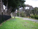
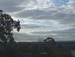
The suburb has a number of natural attractions, including ample parklands, contrasted with large, modern shopping malls.
 The landscape of Templestowe is striking. Gentle, rolling hills extend from east of the Yarra River
flood plains along Templestowe Road (towards the Eastern Freeway) for seven km (4.3 miles) to the north-east. The altitude of the plain above sea level is 50 m, and the topography
is subdued and mostly flat; the hills are just below 60 m, the slopes rounded, and there are several forrested gullies.
Since the Southern Ocean
sea-level stabilised 3000 years ago, the rivers of the Port Phillip Sunkland ceased eroding their channels and have been depositing an alluvium of silt, clay, and sand in the lower reaches of the flood plains. Over the last 2000 years the slowly coursing river widened the build-up to form a series of meander
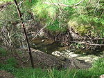
s (billabong
s). In Warrandyte the river flows through a steep sided gorge for a distance of 26 km, forming an "antecedent" stream: the absence of steps or high river terraces on long spurs inside meander bends indicates some relatively recent deposition. In the suburb itself, at the confluence with the Plenty River, the valley opens up into "wide flood plains surrounded by undulating country of tertiary geology
."
 Degradation
of the soils in the steep slopes at the river's edge has been exacerbated over the last century by unsustainable agricultural processes (such as the harvesting of storm-felled trees), deforestation and the introduction of rabbit
s; following the 2006 drought, the community newspaper
has reported several times the population was only brought under in 2007, 12 years after baiting programs were begun and that more conservation funding is needed to halt the loss of vegetation along the river. Most of the surrounding area has been cleared for agricultural and orchard use, although an "urban forest" exists in the densely populated rural-residential areas. There is a wide diversity of growth within the flood plain.
volcanic intrusions containing rich auriferous quartz
and feldspar
are present on both sides of the river, as well as in the hills to the west (Heidelberg
). The Newer Volcanics
(2.5 to 5 million years old) are concentrated in the upper reaches of the river but it was their flows just upstream that blocked off the depression into Port Phillip Bay, forming a large lake at Fairfield
. The Yarra subsequently cut across to the east of the flow and the lake was drained. The basalt
is exposed at both the Fairfield locality and along the Plenty River. Quaternary sediments in the form of river alluvium, including half a metre of fine gravel, have been deposited on the floodplains and in the river channels; only some of this forms high river terraces, most material being diverted in massive annual floods.
A report from The Argus
in 1923 gives rare insight to interest in the area. It had been recently accepted that "when the coastal plain is overweighted the back country rises" due to inexorable forces
moulding the surface of the earth, and the so-called "Templestowe anticline
" was studied as representative of microscopic faulting which accommodated this elevation of the eastern suburbs. It was observed that the new reserve grounds established along it would become a "Mecca
" for geologists:
of the Kulin nation
(a confederation of at least five language groups) via the dreamtime pathways. Most interpretations depict a pathway from the area today known as Port Phillip Bay along the Goulburn River
, across The Black Spur at Healesville and down the Yarra River to what are now the cities of Manningham and Nillumbik, in the eastern suburbs
.
The land to the east of Melbourne was acquired by The Crown
early in the 19th century, during the Stawellian timocracy
; the Wurundjeri
people, who inhabited the Yarra River Valley
and its tributaries for 500 years, were granted "permissive occupancy" of Coranderrk
Station, near Healesville, and forcibly resettled. Extensive trading networks had been established with the predominantly British colonists prior to pastoralism in 1835, George Langhorne, a missionary in Port Phillip from 1836 to 1839, noting in his recourse to the Colony of New South Wales that a substantial monetary trade was well established in 1838: "A considerable number of the blacks obtain food and clothing for themselves by shooting the Menura pheasant or Bullun-Bullun for the sake of the tails, which they sell to the whites." The increasingly rapid acquisition of guns, the lure of exotic foods and a societal emphasis on maintaining kin relationships meant they weren't attracted to the mission. According to John Green, the Inspector of Aboriginal Stations in Victoria and later manager of Corranderrk, the people were able to achieve a "sustainable" degree of economic independence: "In the course of one week or so they will all be living in huts instead of willams [traditional housing]; they have also during that time [four months] made as many rugs, which has enabled them to buy boots, hats, coats etc., and some of them [have] even bought horses."
The subsequent, pioneer settlement process was drawn out due to the area's geographic inaccessibility relative to that west of Melbourne: the land was hilly and thickly timbered, as opposed to the open plains of greater Geelong. Additionally, it was believed that the soil was shallow and infertile, a fallacy which was not debunked until T. R. Nutt surveyed the land in 1839.
In 1841 Frederic Unwin, a Sydney solicitor, purchased 5120 acres (20.7 km²) or eight square miles of land, including the part of Templestowe south of Foote St/Reynolds Rd and west of Church Rd. The land was purchased from the Crown for one pound an acre under the terms of the short-lived Special Survey
regulations. The area was sometimes known as Unwin's Special Survey
.
The original Templestowe village was situated between what is today Finns Reserve and the Templestowe Hotel, as this expanse of land ran by a fresh water stream and was north of Unwin's Special Survey
. It was formally recognised in legislative writ following the establishment of the school in Tom Hicks' barn, as the educational facility was also utilised in an official capacity by the community, that is, it facilitated the burial of the dead and town meetings. The original building was roughly situated on the corner of Serpells Road and Williamsons Road and was first cited in a judicial trial in 1856.
The previous month Wekey had purchased 211 acre (0.85388746 km²) in Lower Plenty, via The Victoria Vineyard and Garden Fruit Company of which he was manager, with a vision to start a wine industry in the new settlement of Melbourne.
Wekey's toll bridge plan, backed by a group of Melbourne businessmen who would form the ‘Templestowe Bridge Committee’, attracted the necessary shareholders and the project was underway. Colonial Architect of the day, James Balmain did the design as a private commission, engineers and builders were Allott and Greenwood. The foundation stone, laid by John Hodgson M.L.C., on August 18, 1855, concealed a manuscript giving details of the people at the ceremony.
The bridge would have a span of 43 metres and a width of eight metres. It would cost 2200 English Pounds ($US800,000 in today’s currency). It would be located at what is now Finns Reserve [near the intersection of Thompsons Road and Foote Street] and Bonds Road, Lower Plenty, the land for Bonds Road being donated by local landowners John Seymour and David Bell. And the Central Road Board agreed to level the road to the bridge on the Templestowe side through the estate of Henry Stooke.
Meantime Wekey conceived a plan for another bridge at Studley Park to improve and shorten the trip to the city even further. By September 21, 1855 the plan for this second bridge was underway.
A stoppage in the works of the Templestowe Bridge was explained by Wekey on September 22, as being a dispute between the Board and the contractors over payment when the foundation on the Lower Plenty side was found to be different than expected, causing a change in the design - the contractors were wanting more money to accommodate this.
Unfortunately in January 1856 the Victoria Vineyard and Garden Fruit Company was forced to sell its land. The sale was to Mr King for eight English Pounds an acre. The company was to be wound up shortly after.
It appears the Templestowe Bridge was operating by this time.
In March 1862, a deputation of Eltham residents approached the Commissioner of Railways and Roads, requesting the government buy the Templestowe Bridge then give it back to the Eltham District Road Board, as while its toll earning capability was not as “remunerative” as had been hoped, the bridge was a “great public convenience”. This request was denied.
In October 1863 there was a great flood causing the Yarra to rise 12 metres - it even flooded Elizabeth Street city. A number of bridges were washed away.
In March 1865 a deputation of Templestowe residents to the Acting Commissioner of Roads and Bridges, offered 600 English Pounds raised by them towards a new bridge to replace the Templestowe Bridge and requested a government grant towards the cost. The Acting Commissioner “promised to give the matter further consideration” though "he did not see from what fund a sum of money could be granted to them”.
A repair job was carried out over 1873 and 1874.
There were several more large floods notably in October, 1923 when the Templestowe Bridge, “a solid wooden structure on an iron girder, with stone supports” almost washed away again. The bridge also appears to have survived the significant December, 1934 flood as it is mentioned in a news article in The Argus newspaper in February 1935. No other references have yet been found. And no bridge picture has been found either.
The last bits washed away in the 1960s according to local folklore. And there's a suspicious bluestone wall right near the spot on the Templestowe side!
Around 1855 another bridge was built nearby in what is now Lower Plenty but over the Plenty River. This bridge, bluestone blocks and steel, still stands today and is part of the Plenty River Trail close to the Heidelberg Golf Club and the Lower Plenty Hotel. It is possible that the Templestowe Bridge was similar in appearance to this.
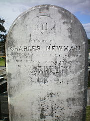 The first permanent resident in Templestowe was Major Charles Newman (11 Dec 1783 - 12 Dec 1865). He served for 30 years in the Honourable East India Company and rose to the rank of Major in the 51st Regiment of the Indian Army
, the Bengal Native Infantry
. As his vision had degraded, Newman retired from the military and migrated to the penal colony
of Van Diemen's Land
with his wife, children, and two step daughters arriving on the Ship Princess Victoria on the 10th Dec 1834. He purchased a large area of land near the town of Pontville, which was to become the colony's second largest estate. Hearing that land was selling quickly in the newly formed town of Melbourne, he purchased 36 km² (13.9 sq mi) during the 1830s around what is now Newmans Road. In 1840 he began construction of Pontville Homestead, relocating there with his remaining family in 1843. The Newman family were at the time the furthest settlers east of Melbourne. Their descendants occupied the land until 1955. The only descendants to still carry the Newman name today are the Webster Family. The other founding families include:

There was an early settlement of Irish and Scottish folk from the ship "Midlothian" through Bulleen and Templestowe, which had arrived in June 1839. The grassland there was interspersed with large Manna and River Red (Be-al) gum trees and broken up by chains of lagoons, the largest of which, called Lake Bulleen, was surrounded by impenetrable reeds that stove off attempts to drain it for irrigation. Due to the distribution of raised ground, the flats were always flooding and for a long time only the poorest (non-English) immigrants leased "pastoral" land from Unwins Special Survey, the estate of the Port Phillip District Authority. Hence although far from prosperous, the farmers living close to nature, most were independent, such that a private Presbyterian school was begun for the district in 1843:
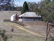 Pontville Homestead was constructed in the early 1840s on part of Newman's pastoral holding, at the confluence of the Yarra River and the Mullum-Mullum Creek
. The remains of his first dwelling, a turf hut, was located near the site. Pontville now comprises a house constructed c. 1843-1850 and extended in the 1870s, remnant
plantings, cottage foundations, outbuildings, bridge foundations, tracks,
and a range of other features associated with the farming use of the area
since the 1830s. Pontville was acquired by the Melbourne and Metropolitan Board of Works
in 1978, and Melbourne Water and Parks
now manages the property as part of Paddle Reserve.
Pontville Homestead is socially, if not in practice, one of the last pastoral selections on the Yarra River within the metropolitan area, and is associated with the earliest development of the Templestowe area. Newman, one of only two ex-Indian Army officers resident in Victoria at the time, was influential in the development of Australian colonial society, and his Indian experience strongly influenced the architectural form of the Pontville homestead. Newman was also associated with gold prospecting in the district following the discovery of gold at Anderson Creek
in Warrandyte. He was among the first in south-eastern Australia to mine quartz reefs
.
Pontville is historically and aesthetically significant amongst the early towns as its landscape contributes to the greater understanding of 1840s agricultural and garden history, as well as for containing numerous relics of aboriginal life. The survival of its formal garden terracing and the presence Hawthorn hedgerows, used for fencing, is unusual. In his book on pastoralism in Tasmania and the 1920s conflict
with the island natives, Keith Windschuttle
writes:
The property itself (now subdivided) has several remnant plantings of the colonial era including Himalayan Cypress
, Black Mulberry
and willow
trees; and, the integrity of ancient scar trees, ancestral camping sites and other spirit places of the Wurundjeri aborigines which was respected by the Newman family. They can be observed in their original form along the trail systems
at the Tikalara ("meeting place") plains tract of the Mullum-Mullum Creek.
Pontville is architecturally important in the evidence surviving from the original homestead building, most notably its distinctive Indian Bungalow form (a core of three interconnected rooms surrounded by a broad verandah
formed by the continuation of the main hipped roof slope, within which the ends were built in to create further rooms) and elements of the original fabric which provide a technical history of colonialism. Important items include a displaced hearth of a stone clearly imported from outside the Port Phillip District, possibly English
millstone grit
, some unexplained sallow cream bricks, probably of local manufacture, pit sawn hardwood ceiling joists, and a stair opening in the ceiling trimmed with tusk tenon joints. Other significant elements are the plaster finishes and remnant ruled lime stucco - the oldest such surface finish in authentic condition to be identified in Victoria, if not Australia. Indian influenced houses are a significant element in Australian colonial architecture, but are extremely
rare in Victoria. Associated with the homestead building are the farm outbuildings which are important for their ability to contribute to the historical understanding of the homestead property.
Pontville is archaeologically important for the below ground remains inherent in the location of, and the material contained within the archaeological deposits associated with Newman's turf hut and the subsequent homestead building, cottage, associated farm and rubbish deposits. The structures, deposits and associated artefacts are important for their potential to provide an understanding of the conditions in which a squatting family lived in the earliest days of the Port Phillip settlement.
and Yarra River. Settlers to the south were known to have called the area "the forest", in reference to its stringybark
forests and other gum trees.
The name Templestowe was chosen when a village was proclaimed. Its exact origins are unknown, although a "Templestowe" is mentioned in the book Ivanhoe
by Sir Walter Scott
—supposedly modelled after the Temple Newsam
preceptory at Leeds
. As the village of Ivanhoe
was settled immediately prior to Templestowe, it is believed by some that the name was chosen to preserve the literary parallel.
Templestowe Post Office opened on 1 July 1860.

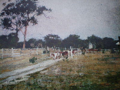
Dairy farming was the primary vocation of the pioneer settlers, and was practiced along the river flats in Templestowe and Bulleen
well into the 20th century. Orcharding was taken up in the 1870s, soon providing prosperity for the district. Apples, peaches, lemons, pears and other stone fruits were grown, providing inspiration for the post-modern "peel" structure on Fitzsimons Lane. Fruit, vine-growers and market gardeners were soon able to build new and more comfortable houses, using brick and weatherboard as materials. Many of these houses still exist, although for the most part they have been modernised beyond the scope for heritage classification by the National Trust of Australia
.
The "River Peel" sculpture was installed in 2001 as part of the Manningham City Gateway Sculpture Project.
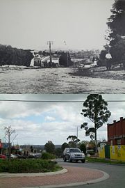
Until the expansionism of the 1970s, Templestowe was scarcely populated. Additionally, it was then part of the so-called "green belt" of Melbourne and subdivision into less than 20,000 m² (2 hectares) was not possible in many parts of the suburb. As Melbourne spread past Kew
and Balwyn, the price of land escalated and pressure mounted to change the boundaries of the restricted land subdivision. By the 1980s
Templestowe was being openly marketed as an alternative to the "dry suburbs". The suburb today has many nouveau riche
mansions. In 2006, a property on Church Road was sold for $
7.2 million, a record for the area.
Templestowe lies between two of Melbourne's rail services (the Hurstbridge and Lilydale lines) and did not facilitate the city's urban development. Throughout the 1970s the Doncaster line
was planned by the state government to run down the middle of the Eastern Freeway and serve the suburb, with land acquired for the line but sold in the 1980s.
A number of major roads combine to provide the basis for the metro infrastructure. They include:
The area has since been built into and, while there is still no rail service, there is now a modest bus network operating routes to the city in the west, Box Hill
and Blackburn
in the south, and Ringwood
in the east. Service is comparatively poor, with average interval times between buses of one hour after peak hours and few services running after 10pm (departure time), although it is likely to improve from 2007 to 2010 under the Victorian Labor
Government
's $1.4 billion "Smart Buses" program.
Following the Sir Rod Eddington
-produced report into improving east-west travel, which included 20 recommendations for the area, the professor of public transport Graham Currie gave his support of expanding the bus transit system (eight older vehicles were replaced in 2007) but argued the need for rapid transit lanes throughout Manningham as an alternative to developing light and heavy rail. This would involve "separate road space so (specialised buses) don't have to wait in traffic or at traffic lights" as a solution to arterial congestion, without need for the extension of tram route 48
to Doncaster Hill favoured by the Manningham City Council.
 There are currently five state schools (Serpell, Templestowe Heights, Templestowe Park and Templestowe Valley) and two Catholic schools (Saint Charles Borromeo and
Saint Kevin's), providing primary education
to the suburb. Templestowe College serves some of the demand for secondary education
. However, Templestowe College, Templestowe Valley Primary School, St Kevins PS and Templestowe Heights PS are located either on the border of Templestowe and Templestowe Lower or in Templestowe Lower.
 The suburb has an Australian Rules football team, The Templestowe Dockers, competing in the Eastern Football League
.
The suburb also has a Cricket
team, Templestowe Cricket Club, competing in the Box Hill Reporter District Cricket Association (BHRDCA) they use the above football clubs home ground in summer.
The suburb had one recognised Football (soccer) team, Eastern Titans FC, playing in the amateur leagues. In 2011 the team and its players became part of Old Camberwell Grammarians Football Club ("The Wellers"), competing in Football Victoria Thirds league.
Templestowe Province
Templestowe Province was an electorate of the Victorian Legislative Council. It existed as a two-member electorate from 1967 to 2006, with members serving alternating eight-year terms. It was traditionally held by the Liberal Party of Australia, but was held by the Australian Labor Party on two...
.
Templestowe is a suburb in Melbourne
Melbourne
Melbourne is the capital and most populous city in the state of Victoria, and the second most populous city in Australia. The Melbourne City Centre is the hub of the greater metropolitan area and the Census statistical division—of which "Melbourne" is the common name. As of June 2009, the greater...
, Victoria
Victoria (Australia)
Victoria is the second most populous state in Australia. Geographically the smallest mainland state, Victoria is bordered by New South Wales, South Australia, and Tasmania on Boundary Islet to the north, west and south respectively....
, Australia
Australia
Australia , officially the Commonwealth of Australia, is a country in the Southern Hemisphere comprising the mainland of the Australian continent, the island of Tasmania, and numerous smaller islands in the Indian and Pacific Oceans. It is the world's sixth-largest country by total area...
, 17 km north-east from Melbourne's central business district
Melbourne city centre
Melbourne City Centre is an area of Melbourne in Victoria, Australia. It is not to be confused with the larger local government area of the City of Melbourne...
. Its Local Government Area is the City of Manningham
City of Manningham
The City of Manningham is a Local Government Area in Victoria, Australia. It is located in the northeastern suburbs of Melbourne. The total population is 118,544 , divided up into 10 suburbs, the largest being Doncaster and Templestowe, over an area of 113 square kilometres.The district spans a...
. At the 2006 Census, Templestowe had a population of 16,428.
The suburb has a number of natural attractions, including ample parklands, contrasted with large, modern shopping malls.
Geography
Templestowe is located in the North-Eastern area of Melbourne. Templestowe is bordered by the Yarra River, King Street, Victoria Street, Blackburn Road and some parks.Yarra River
The Yarra River, originally Birrarung, is a river in east-central Victoria, Australia. The lower stretches of the river is where the city of Melbourne was established in 1835 and today Greater Melbourne dominates and influences the landscape of its lower reaches...
flood plains along Templestowe Road (towards the Eastern Freeway) for seven km (4.3 miles) to the north-east. The altitude of the plain above sea level is 50 m, and the topography
Topography
Topography is the study of Earth's surface shape and features or those ofplanets, moons, and asteroids...
is subdued and mostly flat; the hills are just below 60 m, the slopes rounded, and there are several forrested gullies.
Since the Southern Ocean
Southern Ocean
The Southern Ocean comprises the southernmost waters of the World Ocean, generally taken to be south of 60°S latitude and encircling Antarctica. It is usually regarded as the fourth-largest of the five principal oceanic divisions...
sea-level stabilised 3000 years ago, the rivers of the Port Phillip Sunkland ceased eroding their channels and have been depositing an alluvium of silt, clay, and sand in the lower reaches of the flood plains. Over the last 2000 years the slowly coursing river widened the build-up to form a series of meander
Meander
A meander in general is a bend in a sinuous watercourse. A meander is formed when the moving water in a stream erodes the outer banks and widens its valley. A stream of any volume may assume a meandering course, alternately eroding sediments from the outside of a bend and depositing them on the...
s (billabong
Billabong
Billabong is an Australian English word meaning a small lake, specifically an oxbow lake, a section of still water adjacent to a river, cut off by a change in the watercourse. Billabongs are usually formed when the path of a creek or river changes, leaving the former branch with a dead end...
s). In Warrandyte the river flows through a steep sided gorge for a distance of 26 km, forming an "antecedent" stream: the absence of steps or high river terraces on long spurs inside meander bends indicates some relatively recent deposition. In the suburb itself, at the confluence with the Plenty River, the valley opens up into "wide flood plains surrounded by undulating country of tertiary geology
Tertiary
The Tertiary is a deprecated term for a geologic period 65 million to 2.6 million years ago. The Tertiary covered the time span between the superseded Secondary period and the Quaternary...
."
Soils retrogression and degradation
Soil retrogression and degradation are two regressive evolution processes associated with the loss of equilibrium of a stable soil. Retrogression is primarily due to erosion and corresponds to a phenomenon where succession reverts back to pioneer conditions . Degradation is an evolution,...
of the soils in the steep slopes at the river's edge has been exacerbated over the last century by unsustainable agricultural processes (such as the harvesting of storm-felled trees), deforestation and the introduction of rabbit
Rabbit
Rabbits are small mammals in the family Leporidae of the order Lagomorpha, found in several parts of the world...
s; following the 2006 drought, the community newspaper
Newspaper
A newspaper is a scheduled publication containing news of current events, informative articles, diverse features and advertising. It usually is printed on relatively inexpensive, low-grade paper such as newsprint. By 2007, there were 6580 daily newspapers in the world selling 395 million copies a...
has reported several times the population was only brought under in 2007, 12 years after baiting programs were begun and that more conservation funding is needed to halt the loss of vegetation along the river. Most of the surrounding area has been cleared for agricultural and orchard use, although an "urban forest" exists in the densely populated rural-residential areas. There is a wide diversity of growth within the flood plain.
Climate
Most of the area corresponds to the climate recorded in Melbourne, though some variation has been recorded in the hills to the north-east. The rainfall in this forrested area is 782 mm in 169 rain days per year, which exceeds the metropolitan average of 655 mm in 143 rain days by approximately 12 mm daily.Geology
DevonianDevonian
The Devonian is a geologic period and system of the Paleozoic Era spanning from the end of the Silurian Period, about 416.0 ± 2.8 Mya , to the beginning of the Carboniferous Period, about 359.2 ± 2.5 Mya...
volcanic intrusions containing rich auriferous quartz
Quartz
Quartz is the second-most-abundant mineral in the Earth's continental crust, after feldspar. It is made up of a continuous framework of SiO4 silicon–oxygen tetrahedra, with each oxygen being shared between two tetrahedra, giving an overall formula SiO2. There are many different varieties of quartz,...
and feldspar
Feldspar
Feldspars are a group of rock-forming tectosilicate minerals which make up as much as 60% of the Earth's crust....
are present on both sides of the river, as well as in the hills to the west (Heidelberg
Heidelberg, Victoria
Heidelberg is a suburb in Melbourne, Victoria, Australia, 11 km north-east from Melbourne's central business district. Its Local Government Area is the City of Banyule....
). The Newer Volcanics
Newer Volcanics Province
The Newer Volcanics Province is a complex of volcanic centres formed by the East Australia hotspot across south-eastern Australia. It has an area of 6,000 square miles with over 400 vents and contains the youngest volcanoes in Australia...
(2.5 to 5 million years old) are concentrated in the upper reaches of the river but it was their flows just upstream that blocked off the depression into Port Phillip Bay, forming a large lake at Fairfield
Fairfield, Victoria
Fairfield is a suburb in Melbourne, Victoria, Australia, 6 km north-east from Melbourne's central business district. Its Local Government Area are the Cities of Darebin and Yarra...
. The Yarra subsequently cut across to the east of the flow and the lake was drained. The basalt
Basalt
Basalt is a common extrusive volcanic rock. It is usually grey to black and fine-grained due to rapid cooling of lava at the surface of a planet. It may be porphyritic containing larger crystals in a fine matrix, or vesicular, or frothy scoria. Unweathered basalt is black or grey...
is exposed at both the Fairfield locality and along the Plenty River. Quaternary sediments in the form of river alluvium, including half a metre of fine gravel, have been deposited on the floodplains and in the river channels; only some of this forms high river terraces, most material being diverted in massive annual floods.
A report from The Argus
The Argus (Australia)
The Argus was a morning daily newspaper in Melbourne established in 1846 and closed in 1957. Widely known as a conservative newspaper for most of its history, it adopted a left leaning approach from 1949...
in 1923 gives rare insight to interest in the area. It had been recently accepted that "when the coastal plain is overweighted the back country rises" due to inexorable forces
Isostasy
Isostasy is a term used in geology to refer to the state of gravitational equilibrium between the earth's lithosphere and asthenosphere such that the tectonic plates "float" at an elevation which depends on their thickness and density. This concept is invoked to explain how different topographic...
moulding the surface of the earth, and the so-called "Templestowe anticline
Anticline
In structural geology, an anticline is a fold that is convex up and has its oldest beds at its core. The term is not to be confused with antiform, which is a purely descriptive term for any fold that is convex up. Therefore if age relationships In structural geology, an anticline is a fold that is...
" was studied as representative of microscopic faulting which accommodated this elevation of the eastern suburbs. It was observed that the new reserve grounds established along it would become a "Mecca
Mecca
Mecca is a city in the Hijaz and the capital of Makkah province in Saudi Arabia. The city is located inland from Jeddah in a narrow valley at a height of above sea level...
" for geologists:
History
Templestowe has had two notable waves of human settlement. The first occurred c. 40000 BCE, its history being preserved in legend amongst the tribesIndigenous Australians
Indigenous Australians are the original inhabitants of the Australian continent and nearby islands. The Aboriginal Indigenous Australians migrated from the Indian continent around 75,000 to 100,000 years ago....
of the Kulin nation
Kulin
The Kulin nation, was an alliance of five Indigenous Australian nations in Central Victoria, Australia, prior to European settlement. Their collective territory extended to around Port Phillip and Western Port, up into the Great Dividing Range and the Loddon and Goulburn River valleys. To their...
(a confederation of at least five language groups) via the dreamtime pathways. Most interpretations depict a pathway from the area today known as Port Phillip Bay along the Goulburn River
Goulburn River (Victoria)
The Goulburn River is a major inland river in Victoria, Australia.The headwaters of the Goulburn River rise in the western end of the Victoria Alps, near Mount Buller. The Eildon Dam creates Lake Eildon, a major storage of water for irrigation...
, across The Black Spur at Healesville and down the Yarra River to what are now the cities of Manningham and Nillumbik, in the eastern suburbs
Eastern Suburbs (Melbourne)
The Eastern Suburbs is a general term used to describe the metropolitan area directly to the east, south-east and north-east of the Melbourne central business district in Melbourne, Victoria, Australia. The eastern suburbs are the most populated area of Melbourne with over 2, 000, 000 residents...
.
The land to the east of Melbourne was acquired by The Crown
The Crown
The Crown is a corporation sole that in the Commonwealth realms and any provincial or state sub-divisions thereof represents the legal embodiment of governance, whether executive, legislative, or judicial...
early in the 19th century, during the Stawellian timocracy
Timocracy
Constitutional theory defines a timocracy as either:# a state where only property owners may participate in government# a government in which love of honor is the ruling principle...
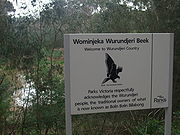
; the Wurundjeri
Wurundjeri
The Wurundjeri are a people of the Indigenous Australian nation of the Woiwurrung language group, in the Kulin alliance, who occupy the Birrarung Valley, its tributaries and the present location of Melbourne, Australia...
people, who inhabited the Yarra River Valley
Yarra Valley
The Yarra Valley is the name given to the region surrounding the Yarra River in Victoria, Australia. The river originates approximately 90 kilometres east of the City of Melbourne and flows towards it and out into Port Phillip Bay...
and its tributaries for 500 years, were granted "permissive occupancy" of Coranderrk
Coranderrk
Coranderrk was an Indigenous Australian mission station set up in 1863 to provide land under the policy of concentration, for Aboriginal people who had been dispossessed by the arrival of Europeans to the state of Victoria 30 years prior. The mission was formally closed in 1924 with most residents...
Station, near Healesville, and forcibly resettled. Extensive trading networks had been established with the predominantly British colonists prior to pastoralism in 1835, George Langhorne, a missionary in Port Phillip from 1836 to 1839, noting in his recourse to the Colony of New South Wales that a substantial monetary trade was well established in 1838: "A considerable number of the blacks obtain food and clothing for themselves by shooting the Menura pheasant or Bullun-Bullun for the sake of the tails, which they sell to the whites." The increasingly rapid acquisition of guns, the lure of exotic foods and a societal emphasis on maintaining kin relationships meant they weren't attracted to the mission. According to John Green, the Inspector of Aboriginal Stations in Victoria and later manager of Corranderrk, the people were able to achieve a "sustainable" degree of economic independence: "In the course of one week or so they will all be living in huts instead of willams [traditional housing]; they have also during that time [four months] made as many rugs, which has enabled them to buy boots, hats, coats etc., and some of them [have] even bought horses."
The subsequent, pioneer settlement process was drawn out due to the area's geographic inaccessibility relative to that west of Melbourne: the land was hilly and thickly timbered, as opposed to the open plains of greater Geelong. Additionally, it was believed that the soil was shallow and infertile, a fallacy which was not debunked until T. R. Nutt surveyed the land in 1839.
In 1841 Frederic Unwin, a Sydney solicitor, purchased 5120 acres (20.7 km²) or eight square miles of land, including the part of Templestowe south of Foote St/Reynolds Rd and west of Church Rd. The land was purchased from the Crown for one pound an acre under the terms of the short-lived Special Survey
Port Phillip District Special Surveys
In August 1840, the Colonial Land and Emigration Commissioners of the British Government decided to allow the purchase of land anywhere in the Port Phillip District of New South Wales – now Victoria, Australia. Special Surveys could be requested to enable the purchase of , or eight square...
regulations. The area was sometimes known as Unwin's Special Survey
Unwin's Special Survey
In 1841, Frederic Unwin, a Sydney solicitor, purchased 5,120 acres or eight square miles of land approximately 10 km north-east of Melbourne, Victoria, Australia...
.
The original Templestowe village was situated between what is today Finns Reserve and the Templestowe Hotel, as this expanse of land ran by a fresh water stream and was north of Unwin's Special Survey
Unwin's Special Survey
In 1841, Frederic Unwin, a Sydney solicitor, purchased 5,120 acres or eight square miles of land approximately 10 km north-east of Melbourne, Victoria, Australia...
. It was formally recognised in legislative writ following the establishment of the school in Tom Hicks' barn, as the educational facility was also utilised in an official capacity by the community, that is, it facilitated the burial of the dead and town meetings. The original building was roughly situated on the corner of Serpells Road and Williamsons Road and was first cited in a judicial trial in 1856.
The Sad Story of Templestowe Bridge (1855-1863, 1873-1935?)
In March 1855, Hungarian immigrant Sigismund Wekey held a meeting at the Bulleen Hotel and called for shareholders, each “according to his means”, in a proposed toll bridge, the first bridge ever built over the Upper Yarra, joining Templestowe to what is now Lower Plenty. The bridge, in replacing a tolled punt being operated by Wekey's company, would cut five kilometres off the trip from Eltham township to Melbourne, it was claimed at the meeting.The previous month Wekey had purchased 211 acre (0.85388746 km²) in Lower Plenty, via The Victoria Vineyard and Garden Fruit Company of which he was manager, with a vision to start a wine industry in the new settlement of Melbourne.
Wekey's toll bridge plan, backed by a group of Melbourne businessmen who would form the ‘Templestowe Bridge Committee’, attracted the necessary shareholders and the project was underway. Colonial Architect of the day, James Balmain did the design as a private commission, engineers and builders were Allott and Greenwood. The foundation stone, laid by John Hodgson M.L.C., on August 18, 1855, concealed a manuscript giving details of the people at the ceremony.
The bridge would have a span of 43 metres and a width of eight metres. It would cost 2200 English Pounds ($US800,000 in today’s currency). It would be located at what is now Finns Reserve [near the intersection of Thompsons Road and Foote Street] and Bonds Road, Lower Plenty, the land for Bonds Road being donated by local landowners John Seymour and David Bell. And the Central Road Board agreed to level the road to the bridge on the Templestowe side through the estate of Henry Stooke.
Meantime Wekey conceived a plan for another bridge at Studley Park to improve and shorten the trip to the city even further. By September 21, 1855 the plan for this second bridge was underway.
A stoppage in the works of the Templestowe Bridge was explained by Wekey on September 22, as being a dispute between the Board and the contractors over payment when the foundation on the Lower Plenty side was found to be different than expected, causing a change in the design - the contractors were wanting more money to accommodate this.
Unfortunately in January 1856 the Victoria Vineyard and Garden Fruit Company was forced to sell its land. The sale was to Mr King for eight English Pounds an acre. The company was to be wound up shortly after.
It appears the Templestowe Bridge was operating by this time.
In March 1862, a deputation of Eltham residents approached the Commissioner of Railways and Roads, requesting the government buy the Templestowe Bridge then give it back to the Eltham District Road Board, as while its toll earning capability was not as “remunerative” as had been hoped, the bridge was a “great public convenience”. This request was denied.
In October 1863 there was a great flood causing the Yarra to rise 12 metres - it even flooded Elizabeth Street city. A number of bridges were washed away.
In March 1865 a deputation of Templestowe residents to the Acting Commissioner of Roads and Bridges, offered 600 English Pounds raised by them towards a new bridge to replace the Templestowe Bridge and requested a government grant towards the cost. The Acting Commissioner “promised to give the matter further consideration” though "he did not see from what fund a sum of money could be granted to them”.
A repair job was carried out over 1873 and 1874.
There were several more large floods notably in October, 1923 when the Templestowe Bridge, “a solid wooden structure on an iron girder, with stone supports” almost washed away again. The bridge also appears to have survived the significant December, 1934 flood as it is mentioned in a news article in The Argus newspaper in February 1935. No other references have yet been found. And no bridge picture has been found either.
The last bits washed away in the 1960s according to local folklore. And there's a suspicious bluestone wall right near the spot on the Templestowe side!
Postscript
The manuscript, concealed under the foundation stone, has not been found.Around 1855 another bridge was built nearby in what is now Lower Plenty but over the Plenty River. This bridge, bluestone blocks and steel, still stands today and is part of the Plenty River Trail close to the Heidelberg Golf Club and the Lower Plenty Hotel. It is possible that the Templestowe Bridge was similar in appearance to this.
Founding families
Indian Army
The Indian Army is the land based branch and the largest component of the Indian Armed Forces. With about 1,100,000 soldiers in active service and about 1,150,000 reserve troops, the Indian Army is the world's largest standing volunteer army...
, the Bengal Native Infantry
Bengal Regiment
The Bengal Regiment is a name given to a large number of infantry regiments raised for the British Indian Army. These regiments were originally raised by the East India Company as part of the Army of Bengal, which was one of the three presidency armies that were absorbed into British Indian Army in...
. As his vision had degraded, Newman retired from the military and migrated to the penal colony
Penal colony
A penal colony is a settlement used to exile prisoners and separate them from the general populace by placing them in a remote location, often an island or distant colonial territory...
of Van Diemen's Land
Van Diemen's Land
Van Diemen's Land was the original name used by most Europeans for the island of Tasmania, now part of Australia. The Dutch explorer Abel Tasman was the first European to land on the shores of Tasmania...
with his wife, children, and two step daughters arriving on the Ship Princess Victoria on the 10th Dec 1834. He purchased a large area of land near the town of Pontville, which was to become the colony's second largest estate. Hearing that land was selling quickly in the newly formed town of Melbourne, he purchased 36 km² (13.9 sq mi) during the 1830s around what is now Newmans Road. In 1840 he began construction of Pontville Homestead, relocating there with his remaining family in 1843. The Newman family were at the time the furthest settlers east of Melbourne. Their descendants occupied the land until 1955. The only descendants to still carry the Newman name today are the Webster Family. The other founding families include:
- Adams
- Atkins
- Bell
- Britton
- Clancey
- Collins
- Channey
- Cunningham
- Chivers
- Eccleston
- Finn
- Fitzsimons
- Fromhold
- Griffin
- Hunter
- Hodgson
- Haughton
- Howett
- Howith
- Hardidge
- Johnston
- Jacks
- Jenkins
- Joughin
- Kent
- Kean
- Lowe
- Lacey
- McNamara
- McEwin
- Mahoney
- McGahy
- Parker
- Rawnsley
- Read
- Rhodes
- Robertson
- Schuhkraft
- Smith
- Stacher
- Stewart
- Taylor
- Trott
- Todd
- Williamson
There was an early settlement of Irish and Scottish folk from the ship "Midlothian" through Bulleen and Templestowe, which had arrived in June 1839. The grassland there was interspersed with large Manna and River Red (Be-al) gum trees and broken up by chains of lagoons, the largest of which, called Lake Bulleen, was surrounded by impenetrable reeds that stove off attempts to drain it for irrigation. Due to the distribution of raised ground, the flats were always flooding and for a long time only the poorest (non-English) immigrants leased "pastoral" land from Unwins Special Survey, the estate of the Port Phillip District Authority. Hence although far from prosperous, the farmers living close to nature, most were independent, such that a private Presbyterian school was begun for the district in 1843:
Pontville Homestead
Mullum-Mullum Creek
Mullum Mullum Creek is a creek in the outer eastern suburbs of Melbourne, Victoria, Australia. It is the main watercourse of the Mullum Mullum Valley, a tributary of the Yarra River and Yarra Valley...
. The remains of his first dwelling, a turf hut, was located near the site. Pontville now comprises a house constructed c. 1843-1850 and extended in the 1870s, remnant
plantings, cottage foundations, outbuildings, bridge foundations, tracks,
and a range of other features associated with the farming use of the area
since the 1830s. Pontville was acquired by the Melbourne and Metropolitan Board of Works
Melbourne and Metropolitan Board of Works
The Melbourne and Metropolitan Board of Works was a public utility board in Melbourne, Australia set up to provide water supply, sewerage and sewage treatment functions for the city...
in 1978, and Melbourne Water and Parks
Melbourne Water
Melbourne Water is a government owned statutory authority that controls much of the water system in Melbourne, Victoria, Australia including the reservoirs, and thesewerage and drainage system that services the city.- Overview :...
now manages the property as part of Paddle Reserve.
Pontville Homestead is socially, if not in practice, one of the last pastoral selections on the Yarra River within the metropolitan area, and is associated with the earliest development of the Templestowe area. Newman, one of only two ex-Indian Army officers resident in Victoria at the time, was influential in the development of Australian colonial society, and his Indian experience strongly influenced the architectural form of the Pontville homestead. Newman was also associated with gold prospecting in the district following the discovery of gold at Anderson Creek
Anderson Creek
Anderson Creek is a tributary of the West Branch Susquehanna River in Clearfield County, Pennsylvania in the United States.-References:*Gertler, Edward. Keystone Canoeing, Seneca Press, 2004. ISBN 0-9749692-0-6...
in Warrandyte. He was among the first in south-eastern Australia to mine quartz reefs
Quartz reef mining
Primary gold typically occurs in quartz veins. The extraction of gold ore from these hard quartz veins was historically referred to as quartz reef mining....
.
Pontville is historically and aesthetically significant amongst the early towns as its landscape contributes to the greater understanding of 1840s agricultural and garden history, as well as for containing numerous relics of aboriginal life. The survival of its formal garden terracing and the presence Hawthorn hedgerows, used for fencing, is unusual. In his book on pastoralism in Tasmania and the 1920s conflict
Black War
The Black War is a term used to describe a period of conflict between British colonists and Tasmanian Aborigines in the early nineteenth century...
with the island natives, Keith Windschuttle
Keith Windschuttle
Keith Windschuttle is an Australian writer, historian, and ABC board member, who has authored several books from the 1970s onwards. These include Unemployment, , which analysed the economic causes and social consequences of unemployment in Australia and advocated a socialist response; The Media: a...
writes:
The property itself (now subdivided) has several remnant plantings of the colonial era including Himalayan Cypress
Cupressus torulosa
Cupressus torulosa, known as the Himalayan cypress, is a species of cypress in southern Asia.-Distribution:The Himalayan cypress is an evergreen conifer tree species is found in the Himalaya from . It is also found on limestone terrain in Sichuan China and in Vietnam.-See also:*Cupressus*Index:...
, Black Mulberry
Black Mulberry
Morus nigra, the Black mulberry, is a species of mulberry. It is native to southwestern Asia, where it has been cultivated for so long that its precise natural range is unknown.-Description:...
and willow
Willow
Willows, sallows, and osiers form the genus Salix, around 400 species of deciduous trees and shrubs, found primarily on moist soils in cold and temperate regions of the Northern Hemisphere...
trees; and, the integrity of ancient scar trees, ancestral camping sites and other spirit places of the Wurundjeri aborigines which was respected by the Newman family. They can be observed in their original form along the trail systems
Mullum Mullum Creek Trail
The Mullum Mullum Creek Trail is a shared use path for cyclists and pedestrians, which follows Mullum Mullum Creek in the outer eastern suburbs in Melbourne, Victoria, Australia....
at the Tikalara ("meeting place") plains tract of the Mullum-Mullum Creek.
Pontville is architecturally important in the evidence surviving from the original homestead building, most notably its distinctive Indian Bungalow form (a core of three interconnected rooms surrounded by a broad verandah
Verandah
A veranda or verandah is a roofed opened gallery or porch. It is also described as an open pillared gallery, generally roofed, built around a central structure...
formed by the continuation of the main hipped roof slope, within which the ends were built in to create further rooms) and elements of the original fabric which provide a technical history of colonialism. Important items include a displaced hearth of a stone clearly imported from outside the Port Phillip District, possibly English
England
England is a country that is part of the United Kingdom. It shares land borders with Scotland to the north and Wales to the west; the Irish Sea is to the north west, the Celtic Sea to the south west, with the North Sea to the east and the English Channel to the south separating it from continental...
millstone grit
Millstone Grit
Millstone Grit is the name given to any of a number of coarse-grained sandstones of Carboniferous age which occur in the Northern England. The name derives from its use in earlier times as a source of millstones for use principally in watermills...
, some unexplained sallow cream bricks, probably of local manufacture, pit sawn hardwood ceiling joists, and a stair opening in the ceiling trimmed with tusk tenon joints. Other significant elements are the plaster finishes and remnant ruled lime stucco - the oldest such surface finish in authentic condition to be identified in Victoria, if not Australia. Indian influenced houses are a significant element in Australian colonial architecture, but are extremely
rare in Victoria. Associated with the homestead building are the farm outbuildings which are important for their ability to contribute to the historical understanding of the homestead property.
Pontville is archaeologically important for the below ground remains inherent in the location of, and the material contained within the archaeological deposits associated with Newman's turf hut and the subsequent homestead building, cottage, associated farm and rubbish deposits. The structures, deposits and associated artefacts are important for their potential to provide an understanding of the conditions in which a squatting family lived in the earliest days of the Port Phillip settlement.
Namesake
The government initially adopted the Aboriginal name "Bulleen", meaning "resting place", to refer to the area near the meeting of the Plenty RiverPlenty River
The Plenty River is a tributary of the Yarra River in Victoria, Australia. Originating in the forested slopes of Mount Disappointment, the Plenty River is the source of Melbourne's first major water supply in the form of the Yan Yean Reservoir....
and Yarra River. Settlers to the south were known to have called the area "the forest", in reference to its stringybark
Eucalyptus obliqua
Eucalyptus obliqua, commonly known as Australian Oak, Brown Top, Brown Top Stringbark, Messmate, Messmate Stringybark, Stringybark and Tasmanian Oak, is a hardwood tree native to south-eastern Australia....
forests and other gum trees.
The name Templestowe was chosen when a village was proclaimed. Its exact origins are unknown, although a "Templestowe" is mentioned in the book Ivanhoe
Ivanhoe
Ivanhoe is a historical fiction novel by Sir Walter Scott in 1819, and set in 12th-century England. Ivanhoe is sometimes credited for increasing interest in Romanticism and Medievalism; John Henry Newman claimed Scott "had first turned men's minds in the direction of the middle ages," while...
by Sir Walter Scott
Walter Scott
Sir Walter Scott, 1st Baronet was a Scottish historical novelist, playwright, and poet, popular throughout much of the world during his time....
—supposedly modelled after the Temple Newsam
Temple Newsam
Temple Newsam is a Tudor-Jacobean house with grounds landscaped by Capability Brown, in Leeds, West Yorkshire, England...
preceptory at Leeds
Leeds
Leeds is a city and metropolitan borough in West Yorkshire, England. In 2001 Leeds' main urban subdivision had a population of 443,247, while the entire city has a population of 798,800 , making it the 30th-most populous city in the European Union.Leeds is the cultural, financial and commercial...
. As the village of Ivanhoe
Ivanhoe, Victoria
Ivanhoe is a suburb in Melbourne, Victoria, Australia, 10 km north-east from Melbourne's central business district. Its Local Government Area is the City of Banyule. At the 2006 Census, Ivanhoe had a population of 10,600.-History:...
was settled immediately prior to Templestowe, it is believed by some that the name was chosen to preserve the literary parallel.
Templestowe Post Office opened on 1 July 1860.
Development
Dairy farming was the primary vocation of the pioneer settlers, and was practiced along the river flats in Templestowe and Bulleen
Bulleen, Victoria
Bulleen is a suburb in Melbourne, Victoria, Australia, 12 km north-east from Melbourne's central business district. Its Local Government Area is the City of Manningham. At the 2006 Census, Bulleen had a population of 10,528.-Etymology:...
well into the 20th century. Orcharding was taken up in the 1870s, soon providing prosperity for the district. Apples, peaches, lemons, pears and other stone fruits were grown, providing inspiration for the post-modern "peel" structure on Fitzsimons Lane. Fruit, vine-growers and market gardeners were soon able to build new and more comfortable houses, using brick and weatherboard as materials. Many of these houses still exist, although for the most part they have been modernised beyond the scope for heritage classification by the National Trust of Australia
National Trust of Australia
The Australian Council of National Trusts is the peak body for community-based, non-government organisations committed to promoting and conserving Australia's indigenous, natural and historic heritage....
.
The "River Peel" sculpture was installed in 2001 as part of the Manningham City Gateway Sculpture Project.
Until the expansionism of the 1970s, Templestowe was scarcely populated. Additionally, it was then part of the so-called "green belt" of Melbourne and subdivision into less than 20,000 m² (2 hectares) was not possible in many parts of the suburb. As Melbourne spread past Kew
Kew, Victoria
Kew is a suburb in Melbourne, Victoria, Australia, 6 km east from Melbourne's central business district. Its Local Government Area is the City of Boroondara. At the 2006 Census, Kew had a population of 22,516....
and Balwyn, the price of land escalated and pressure mounted to change the boundaries of the restricted land subdivision. By the 1980s
1980s
File:1980s decade montage.png|thumb|400px|From left, clockwise: The first Space Shuttle, Columbia, lifted off in 1981; American President Ronald Reagan and Soviet leader Mikhail Gorbachev eased tensions between the two superpowers, leading to the end of the Cold War; The Fall of the Berlin Wall in...
Templestowe was being openly marketed as an alternative to the "dry suburbs". The suburb today has many nouveau riche
Nouveau riche
The nouveau riche , or new money, comprise those who have acquired considerable wealth within their own generation...
mansions. In 2006, a property on Church Road was sold for $
Australian dollar
The Australian dollar is the currency of the Commonwealth of Australia, including Christmas Island, Cocos Islands, and Norfolk Island, as well as the independent Pacific Island states of Kiribati, Nauru and Tuvalu...
7.2 million, a record for the area.
Transport
Templestowe lies between two of Melbourne's rail services (the Hurstbridge and Lilydale lines) and did not facilitate the city's urban development. Throughout the 1970s the Doncaster line
Doncaster railway line, Melbourne
The Doncaster railway line is a proposed suburban railway in the eastern suburbs of Melbourne, Victoria, Australia. Connecting to the existing Melbourne metro railway network at Victoria Park station on the Epping and Hurstbridge lines; the Doncaster line would have served the suburbs of Bulleen,...
was planned by the state government to run down the middle of the Eastern Freeway and serve the suburb, with land acquired for the line but sold in the 1980s.
A number of major roads combine to provide the basis for the metro infrastructure. They include:
- Manningham Road
- Foote Street/Reynolds Road
- High Street
- Thompsons Road
- Williamsons Road/Fitzsimons Lane
- Porter Street
- Blackburn Road
- Newmans Road
- Websters Road (named after Robert William Webster)
The area has since been built into and, while there is still no rail service, there is now a modest bus network operating routes to the city in the west, Box Hill
Box Hill, Victoria
Box Hill is a suburb in Melbourne, Victoria, Australia, 14 km east from Melbourne's central business district. Its Local Government Area is the City of Whitehorse. At the 2006 Census, Box Hill had a population of 8,616....
and Blackburn
Blackburn, Victoria
Blackburn is a suburb in Melbourne, Victoria, Australia, 17 km east from Melbourne's central business district. Its Local Government Area is the City of Whitehorse. At the 2006 Census, Blackburn had a population of 11,958....
in the south, and Ringwood
Ringwood, Victoria
Ringwood is a suburb in Melbourne, Victoria, Australia, east of Melbourne's central business district. Its Local Government Area is the City of Maroondah. At the 2006 Census, Ringwood had a population of 15,185....
in the east. Service is comparatively poor, with average interval times between buses of one hour after peak hours and few services running after 10pm (departure time), although it is likely to improve from 2007 to 2010 under the Victorian Labor
Australian Labor Party
The Australian Labor Party is an Australian political party. It has been the governing party of the Commonwealth of Australia since the 2007 federal election. Julia Gillard is the party's federal parliamentary leader and Prime Minister of Australia...
Government
Government of Victoria
The Government of Victoria, under the Constitution of Australia, ceded certain legislative and judicial powers to the Commonwealth, but retained complete independence in all other areas...
's $1.4 billion "Smart Buses" program.
Following the Sir Rod Eddington
Rod Eddington
Sir Roderick Ian Eddington is an Australian businessman. He is currently chair of the government body Infrastructure Australia, a director of News Corporation, continuing his long association with that company, and has served in other senior positions including as former CEO of British...
-produced report into improving east-west travel, which included 20 recommendations for the area, the professor of public transport Graham Currie gave his support of expanding the bus transit system (eight older vehicles were replaced in 2007) but argued the need for rapid transit lanes throughout Manningham as an alternative to developing light and heavy rail. This would involve "separate road space so (specialised buses) don't have to wait in traffic or at traffic lights" as a solution to arterial congestion, without need for the extension of tram route 48
Melbourne tram route 48
Tram route 48 is a public transport service in Melbourne, Victoria, Australia. It runs from Victoria Harbour, Docklands to North Balwyn via Collins Street, Spring Street, Wellington Parade and Bridge Road...
to Doncaster Hill favoured by the Manningham City Council.
Education
Saint Kevin's), providing primary education
Primary education
A primary school is an institution in which children receive the first stage of compulsory education known as primary or elementary education. Primary school is the preferred term in the United Kingdom and many Commonwealth Nations, and in most publications of the United Nations Educational,...
to the suburb. Templestowe College serves some of the demand for secondary education
Secondary education
Secondary education is the stage of education following primary education. Secondary education includes the final stage of compulsory education and in many countries it is entirely compulsory. The next stage of education is usually college or university...
. However, Templestowe College, Templestowe Valley Primary School, St Kevins PS and Templestowe Heights PS are located either on the border of Templestowe and Templestowe Lower or in Templestowe Lower.
Sporting teams
Eastern Football League (Australia)
The Eastern Football League is an Australian rules football League, based in the eastern suburbs of metropolitan Melbourne....
.
The suburb also has a Cricket
Cricket
Cricket is a bat-and-ball game played between two teams of 11 players on an oval-shaped field, at the centre of which is a rectangular 22-yard long pitch. One team bats, trying to score as many runs as possible while the other team bowls and fields, trying to dismiss the batsmen and thus limit the...
team, Templestowe Cricket Club, competing in the Box Hill Reporter District Cricket Association (BHRDCA) they use the above football clubs home ground in summer.
The suburb had one recognised Football (soccer) team, Eastern Titans FC, playing in the amateur leagues. In 2011 the team and its players became part of Old Camberwell Grammarians Football Club ("The Wellers"), competing in Football Victoria Thirds league.
See also
- City of Doncaster and Templestowe - the former local government area of which Templestowe was a part.