
Starved Rock State Park
Encyclopedia
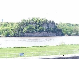
Starved Rock State Park is a state park in Illinois
, characterized by the many canyons within its 2360 acres. Located just southwest of the village of North Utica
, in Deer Park Township
, LaSalle County, Illinois
, along the south bank of the Illinois River
, the park hosts over two million visitors annually.
In the pre-Columbian era, the area was home to Native Americans
, particularly the Kaskaskia
who lived in the Grand Village of the Illinois
across the river. Louis Jolliet
and Jacques Marquette
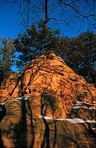
were the first Europeans recorded as exploring the region, and by 1683, the French had established Fort St. Louis on a large sandstone
butte
overlooking the river. According to a native legend, a group of Illinois Confederation (Illini) pursued by the Ottawa
and Potawatomi
fled to the butte in the late 18th century. The Ottawa and Potawatomi besieged the butte until all of the Illini had starved, and the butte became known as Starved Rock. The butte area was designated a U.S. National Historic Landmark
in 1960.
known as the Kankakee Torrent
, which took place somewhere between 14,000 and 17,000 years ago, before humans occupied the area, helped create the park's signature geology and features, which are very unusual for the central plains
.
. These prehistoric indigenous peoples
thrived by hunting for waterfowl and deer with spears; copper
Clovis point
s from these spears have been unearthed in the park. Havana Hopewell
settlers during the Woodland period
(1000 BC – 1000 AD) built earthwork
mounds. They also made crude pottery
and domesticated plants
.
The growth of agriculture and maize surpluses supported the development of the complex Mississippian culture
. Its peoples established permanent settlements in the Mississippi
, Illinois
, and Ohio
river valleys. They harvested maize
, beans
, and pumpkin
s, and were noted for their copper
ornaments. The first interaction with other tribes occurred during this period: artifacts from the major regional chiefdom
and urban complex of Cahokia
, at present-day Collinsville, Illinois
, have been recovered at Illinois River sites.
The earliest group of inhabitants recorded at the region were the historical Kaskaskia
, whose large settlement on the north side of the Illinois River was known as the Grand Village of the Illinois
. The Kaskaskia were members of the Illinois Confederation (Illini), who inhabited the region in the 16th through the 18th centuries. They lived in wigwam
s made of light-weight material. The natives could easily dismantle these structures when they traveled to hunt bison
twice a year. The women gathered tuber
s from nearby swamps as a secondary source of food. Small bands of aggressive Iroquois
settlers arrived in northern Illinois in 1660 in search of new hunting grounds for beaver, stimulating inter-tribal warfare. The Kaskaskia struggled with the Iroquois, who were armed with guns seized from or traded by Europeans in the eastern United States.
In 1673 Louis Jolliet
and Father Jacques Marquette
were the first Europeans to explore the northern portion of the Mississippi River. On their return, they navigated the Illinois River, which they found to be a convenient route to Lake Michigan
. Along the river, they found seventy-three cabins in the Grand Village, whose population rapidly expanded in the next several years. Marquette returned to the village in 1675 to set up the Mission of the Immaculate Conception
, the first Christian
mission in modern-day Illinois. Marquette was joined by fellow Jesuit priest Claude-Jean Allouez
in 1677. By 1680, the Grand Village was home to several hundred native cabins and a population of 6,000-9,000.
In 1680 the Iroquois
temporarily drove the Kaskaskia out of the settlement during the Beaver Wars
, as they were trying to expand their hunting territory. With an increase in French settlers in the area, the Kaskaskia returned by 1683. The French were able to provide the Kaskaskia with guns in exchange for other goods, which they used for defense against the powerful Iroquois, already armed by the English.
 French
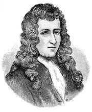
explorers led by René-Robert Cavelier, Sieur de La Salle
built Fort St. Louis on a large butte
by the river in the winter of 1682. Called La Rocher, the butte provided an advantageous position for the fort above the Illinois River. A wooden palisade
was the only form of defenses that La Salle used in securing the site. Inside the fort were a few wooden houses and native shelters. The French intended St. Louis to be the first of several forts to defend against English incursions and keep their settlements confined to the East Coast
. Accompanying the French to the region were allied members of several native tribes from eastern areas, who integrated with the Kaskaskia: the Miami
, Shawnee
, and Mahican
. The tribes established a new settlement at the base of the butte known as Hotel Plaza.
After La Salle's five year monopoly ended La Barre
wished to obtain Fort Saint Louis along with Fort Frontenac for himself. By orders of the governor, traders and his officer were escorted to Illinois. On August 11, 1683 Prudhomme obtained approximately one and three quarters of a mile of the north portage shore.
During the French and Indian Wars
(also known as the Seven Years War and part of the European conflict between Great Britain and France), the French used the fort as a refuge against attacks by Iroquois, who were allied with the British. The Iroquois forced the settlers, then commanded by Henri de Tonti
, to abandon the fort in 1691. De Tonti reorganized the settlers at Fort Pimitoui in modern-day Peoria
.
French troops commanded by Pierre Deliette may have occupied Fort St. Louis from 1714 to 1718; Deliette's jurisdiction over the region ended when the territory was transferred from Canada
to Louisiana
. Fur trappers
and traders used the fort periodically in the early 18th century until it became too dilapidated. No surface remains of the fort are found at the site today. The region was periodically occupied by a variety of native tribes who were forced westward by the expansion of European settlements. These included the Potawatomi
, Ottawa
, and Ojibwe.
On April 20, 1769, an Illinois Confederation warrior assassinated Chief Pontiac
while he was on a diplomatic mission in Cahokia
. According to local legend
, the Ottawa, along with their allies the Potawatomi, attacked a band of Illini along the Illinois River. The tribe climbed to the butte to seek refuge from the attack. The Ottawa and Potawatomi continued the siege until the Illini tribe starved to death. After hearing the story, Europeans referred to the butte as Starved Rock.
near the base of Starved Rock, as well as a concession stand and dance hall. The French and Native American heritage of the region also drew visitors to the site. Walthers set up a variety of walkable trails and harbored small boats near the hotel that made trips along the Illinois River. Visitors could also visit Deer Park (modern-day Matthiessen State Park
) a few miles to the south.
With the growth of competitive sites, Walther struggled to keep the complex economically stable. In 1911, he sold the land to the Illinois State Parks Commission for $146,000. The Commission was initially headquartered at Starved Rock State Park after the land was acquired. The state initially acquired 898 acres and opened Starved Rock State Park as a public facility in 1912.
During its early years, Starved Rock State Park was directly accessible only by railroad. Visitors had reached Starved Rock by rail and ferry since at least 1904, while the property was still a Walther-run resort. Between 1904 and 1908 more than 160,000 people used the ferry that connected Starved Rock to the electric railway line. In 1912, the year the park was opened to the public, attendance was 75,000. By the 1930s other state parks were opened in Illinois but Starved Rock State Park remained the most extensively used park in the system.
Franklin D. Roosevelt
's New Deal
legislation in the 1930s called for the creation of the Civilian Conservation Corps
(CCC) to provide jobs for young men. The focus of this group was to preserve natural areas in the rural United States. CCC Camp 614 was deployed to Starved Rock State Park from the Jefferson Barracks Military Post
in Missouri
. Unlike most CCC groups in the nation, Camp 614 included African American
s. The group, composed of roughly 200 men, constructed trails, shelters, and benches throughout the park. In 1933, the group was joined by Camp 1609 from Fort Sheridan via Readstown
, Wisconsin
. Camp 1609 constructed the Starved Rock Lodge, several surrounding log cabin
s, and a large parking lot
. The lodge was particularly noted for its elegant fireplaces, constructed from limestone
imported from Joliet. Men from camps 614 and 1609 lay more than 25 miles of trails. Camp 614 was eventually reassigned to Illini National Forest
. The men were replaced by those of Camp 2601 from Fort Sheridan in 1934. Camp 2601 constructed the Wildcat Canyon bridge, among others.
When Illinois Route 71
was opened in 1942, it allowed easy automotive access from Chicago
. Starved Rock was declared a National Historic Landmark
in 1960.
The butte has eroded eighteen to forty-eight inches due to foot traffic since the park was developed. To curb this, the Illinois Young Adult Conservation Corps installed a platform and staircase on the landmark in 1981. The CCC-era Starved Rock Lodge and Cabins were added to the National Register of Historic Places
on May 8, 1985. The Illinois Bureau of Tourism listed Starved Rock State Park as one of the "Seven Wonders of Illinois" in 2007. 2.1 million people visited the park in 2010.
In March 1960, three middle-aged women were murdered in the park.
 The summit of Starved Rock was the site of archeological excavations in 1947-1949 by archaeologists from the Illinois State Museum
and the University of Chicago
. The research was continued in 1950 by an archaeologist from State Department of Public Works and Buildings who had joined the project the year before. Archaeologists from the University of Illinois at Chicago
restarted testing at the site for a season in 1974, and later an archaeologist from Illinois State University
continued testing. The 1947-1950 excavations provided the "greater part of the knowledge of the archaeology of Starved Rock".
on June 18, 1998 as part of the Archaeological Sites of Starved Rock Multiple Property Submission.
. It is believed that Hotel Plaza was also the site of a large Native American village that helped support early French explorers
in the region during the 17th and 18th centuries. In more modern historic times the site was the location of a hotel within the state park.
site at the base of the sandstone bluff within the state park's Kaskaskia Canyon. In 1991 subsurface tests of the 183 m2 shelter site were made and determined that evidence existed only for occupation by Upper Mississippian groups. Shaky Shelter Site was added to the National Register of Historic Places on the same date, June 18, 1998, and as part of the same Multiple Property Submission as the Corbin Farm, Hotel Plaza and Little Beaver sites.
Rock shelters, such as the one found at the Shaky Shelter Site, are areas used by human inhabitants that occur in rock overhangs which offer a moderate level of protection against the elements. By 1998 14 occupied rock shelter sites had been identified within the state park. At the time of Shaky Shelter's National Register of Historic Places listing it was the only rock shelter in the park determined to have undisturbed prehistoric features of archaeological significance.
At the time of the 1998 addition of the Corbin Farm and Little Beaver sites to the National Register it had been determined that there were three "village and mound" sites within the park. Besides Corbin Farm and Little Beaver, the Simonson site, an open-air occupation site, is also considered a village and mound site. Simonson Site has faced significant alterations over the years
cliffs of Starved Rock State Park white pine
, Canada yew and northern white cedar are found, these plants are more commonly found further north. On the surfaces of the canyons and cliffs, where it is cooler, other plants are found, examples include: harebell
, reindeer lichen, and mountain holly
. A non-vascular plant
, liverwort
, is also found on the sandstone surfaces throughout Starved Rock State Park. The Indian cucumber root, a rare lily in Illinois, was found in the park in 1939. A lady's slipper orchid has also been found in the park, it, like other orchids, is susceptible to invasive plant species, and changes in habitat.
, featuring mild summers and cold winters capable of producing snow
storms. The highest recorded temperature at the park was 112 °F (44 °C) in 1936, and the record low was −25 °F (-32 °C) in 1985. January is the coldest month at the park, July the warmest, and June the wettest. Starved Rock State Park averages 35.7 inches (906.8 cm) of precipitation
.
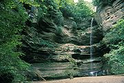 There are over 13 miles (20.9 km) of hiking trails in Starved Rock State Park. There are 18 deep canyon
s in the park; French, LaSalle, Ottawa and St. Louis Canyons feature the more long-lasting waterfall
s at Starved Rock. A trail along the river offers scenic views from attractions such as Lover's Leap Overlook, Eagle Cliff Overlook and Beehive Overlook. Camping
, boating
and fishing
are among the other activities offered in the park. There are 133 campsites at Starved Rock State Park, of those 100 can be reserved. There are also horseback riding trails at Starved Rock on the far western side of the park.
From December through February bald eagles can be viewed at the park, either fishing below the Starved Rock Dam
, where turbulent waters stay unfrozen during the cold winter months or roosting on the Leopold or Plum Island. The Starved Rock State Park Visitor Center loans out binoculars to aspiring birders in exchange for the birder's drivers license.During the winter, sports such as ice skating, tobogganing, cross-country sking and sledding are allowed in parts of the park. Snowmobiling is not allowed at Starved Rock State Park.Waterfalls become constantly changing ice falls during the winter as well. 14 of 18 waterfalls transform into scenic ice falls, with those at LaSalle, French, St. Louis, Tonty, Wildcat, Hennepin, Ottawa and Kaskaskia Canyons being especially scenic. Ice climbing
is another winter activity allowed in select canyons.
. The lodge
has a central lounge, known as the Great Room, and hotel wings and a dining room wing. On its exterior, the lodge is primarily constructed of stone, unhewed logs, clapboard
and wood shingles
. Booten's design intended to impress upon visitors the idea of a "woodsy retreat", this is seen in the way he designed round log purlin
s whose unevenly hewn ends extend beyond the lodge's eaves. Surrounding the lodge are 12 cabins, two large cabins are sited just west of the lodge while the other ten are situated across a steep ravine, known as Fox Canyon, from the lodge. The cabins are constructed of unhewn logs with random corner notches and sit in heavily wooded area meant to evoke a "camping in the woods" feeling. The 12 cabins and the lodge cover an area of 17 acres. Despite the changes through modernization the lodge still retains much of the charm its architect intended.
on May 8, 1985 as part of the Illinois State Park Lodges and Cabins Thematic Resources
Multiple Property Submission. By the National Register's criteria the Lodge and Cabins are considered significant in the areas of architecture and entertainment/recreation. The size of the lodge and the land area the cabins cover are both nearly unrivaled in the Illinois state park system; only Pere Marquette State Park's
Lodge and Cabins come close.
Illinois
Illinois is the fifth-most populous state of the United States of America, and is often noted for being a microcosm of the entire country. With Chicago in the northeast, small industrial cities and great agricultural productivity in central and northern Illinois, and natural resources like coal,...
, characterized by the many canyons within its 2360 acres. Located just southwest of the village of North Utica
North Utica, Illinois
North Utica is a village in Utica Township, LaSalle County, Illinois. The population was 977 at the 2000 United States Census. It is part of the Ottawa–Streator Micropolitan Statistical Area....
, in Deer Park Township
Deer Park Township, LaSalle County, Illinois
Deer Park Township is located in LaSalle County, Illinois. The population was 467 at the 2000 census.- External links :***...
, LaSalle County, Illinois
Illinois
Illinois is the fifth-most populous state of the United States of America, and is often noted for being a microcosm of the entire country. With Chicago in the northeast, small industrial cities and great agricultural productivity in central and northern Illinois, and natural resources like coal,...
, along the south bank of the Illinois River
Illinois River
The Illinois River is a principal tributary of the Mississippi River, approximately long, in the State of Illinois. The river drains a large section of central Illinois, with a drainage basin of . This river was important among Native Americans and early French traders as the principal water route...
, the park hosts over two million visitors annually.
In the pre-Columbian era, the area was home to Native Americans
Indigenous peoples of the Americas
The indigenous peoples of the Americas are the pre-Columbian inhabitants of North and South America, their descendants and other ethnic groups who are identified with those peoples. Indigenous peoples are known in Canada as Aboriginal peoples, and in the United States as Native Americans...
, particularly the Kaskaskia
Kaskaskia
The Kaskaskia were one of about a dozen cognate tribes that made up the Illiniwek Confederation or Illinois Confederation. Their longstanding homeland was in the Great Lakes region...
who lived in the Grand Village of the Illinois
Grand Village of the Illinois
The Grand Village of the Illinois, also called Old Kaskaskia Village, is a site significant for being the best documented historic Native American village in the Illinois River valley...
across the river. Louis Jolliet
Louis Jolliet
Louis Jolliet , also known as Louis Joliet, was a French Canadian explorer known for his discoveries in North America...
and Jacques Marquette
Jacques Marquette
Father Jacques Marquette S.J. , sometimes known as Père Marquette, was a French Jesuit missionary who founded Michigan's first European settlement, Sault Ste. Marie, and later founded St. Ignace, Michigan...
were the first Europeans recorded as exploring the region, and by 1683, the French had established Fort St. Louis on a large sandstone
Sandstone
Sandstone is a sedimentary rock composed mainly of sand-sized minerals or rock grains.Most sandstone is composed of quartz and/or feldspar because these are the most common minerals in the Earth's crust. Like sand, sandstone may be any colour, but the most common colours are tan, brown, yellow,...
butte
Butte
A butte is a conspicuous isolated hill with steep, often vertical sides and a small, relatively flat top; it is smaller than mesas, plateaus, and table landform tables. In some regions, such as the north central and northwestern United States, the word is used for any hill...
overlooking the river. According to a native legend, a group of Illinois Confederation (Illini) pursued by the Ottawa
Ottawa (tribe)
The Odawa or Ottawa, said to mean "traders," are a Native American and First Nations people. They are one of the Anishinaabeg, related to but distinct from the Ojibwe nation. Their original homelands are located on Manitoulin Island, near the northern shores of Lake Huron, on the Bruce Peninsula in...
and Potawatomi
Potawatomi
The Potawatomi are a Native American people of the upper Mississippi River region. They traditionally speak the Potawatomi language, a member of the Algonquian family. In the Potawatomi language, they generally call themselves Bodéwadmi, a name that means "keepers of the fire" and that was applied...
fled to the butte in the late 18th century. The Ottawa and Potawatomi besieged the butte until all of the Illini had starved, and the butte became known as Starved Rock. The butte area was designated a U.S. National Historic Landmark
National Historic Landmark
A National Historic Landmark is a building, site, structure, object, or district, that is officially recognized by the United States government for its historical significance...
in 1960.
Geology
A catastrophic floodGlacial lake outburst flood
A glacial lake outburst flood is a type of outburst flood that occurs when the dam containing a glacial lake fails. The dam can consist of glacier ice or a terminal moraine...
known as the Kankakee Torrent
Kankakee Torrent
The Kankakee Torrent was a catastrophic flood that occurred between 14,000 and 18,000 years ago in the Midwestern United States. It resulted from a breach of a large glacial lake formed by the melting of the Wisconsin Glacier...
, which took place somewhere between 14,000 and 17,000 years ago, before humans occupied the area, helped create the park's signature geology and features, which are very unusual for the central plains
Interior Plains
The Interior Plains is a vast physiographic region that spreads across the Laurentian craton of central North America.-Geography:The Interior Plains are an extensive physiographic division encompassing 8 distinct physiographic provinces, the Interior Low Plateaus, Great Plains, Central Lowland,...
.
Early settlements
This area has been inhabited by humans since 8000 BC. Archeological surveys have located Archaic period (8000 – 2000 BC) settlements along the Illinois RiverIllinois River
The Illinois River is a principal tributary of the Mississippi River, approximately long, in the State of Illinois. The river drains a large section of central Illinois, with a drainage basin of . This river was important among Native Americans and early French traders as the principal water route...
. These prehistoric indigenous peoples
Indigenous peoples
Indigenous peoples are ethnic groups that are defined as indigenous according to one of the various definitions of the term, there is no universally accepted definition but most of which carry connotations of being the "original inhabitants" of a territory....
thrived by hunting for waterfowl and deer with spears; copper
Copper
Copper is a chemical element with the symbol Cu and atomic number 29. It is a ductile metal with very high thermal and electrical conductivity. Pure copper is soft and malleable; an exposed surface has a reddish-orange tarnish...
Clovis point
Clovis point
Clovis points are the characteristically-fluted projectile points associated with the North American Clovis culture. They date to the Paleoindian period around 13,500 years ago. Clovis fluted points are named after the city of Clovis, New Mexico, where examples were first found in 1929.At the right...
s from these spears have been unearthed in the park. Havana Hopewell
Havana Hopewell culture
The Havana Hopewell culture were a Hopewellian people in the Illinois River and Mississippi River valleys in Iowa, Illinois, and Missouri from 200 BCE to 400 CE...
settlers during the Woodland period
Woodland period
The Woodland period of North American pre-Columbian cultures was from roughly 1000 BCE to 1000 CE in the eastern part of North America. The term "Woodland Period" was introduced in the 1930s as a generic header for prehistoric sites falling between the Archaic hunter-gatherers and the...
(1000 BC – 1000 AD) built earthwork
Earthworks (archaeology)
In archaeology, earthwork is a general term to describe artificial changes in land level. Earthworks are often known colloquially as 'lumps and bumps'. Earthworks can themselves be archaeological features or they can show features beneath the surface...
mounds. They also made crude pottery
Pottery
Pottery is the material from which the potteryware is made, of which major types include earthenware, stoneware and porcelain. The place where such wares are made is also called a pottery . Pottery also refers to the art or craft of the potter or the manufacture of pottery...
and domesticated plants
Horticulture
Horticulture is the industry and science of plant cultivation including the process of preparing soil for the planting of seeds, tubers, or cuttings. Horticulturists work and conduct research in the disciplines of plant propagation and cultivation, crop production, plant breeding and genetic...
.
The growth of agriculture and maize surpluses supported the development of the complex Mississippian culture
Mississippian culture
The Mississippian culture was a mound-building Native American culture that flourished in what is now the Midwestern, Eastern, and Southeastern United States from approximately 800 CE to 1500 CE, varying regionally....
. Its peoples established permanent settlements in the Mississippi
Mississippi River
The Mississippi River is the largest river system in North America. Flowing entirely in the United States, this river rises in western Minnesota and meanders slowly southwards for to the Mississippi River Delta at the Gulf of Mexico. With its many tributaries, the Mississippi's watershed drains...
, Illinois
Illinois River
The Illinois River is a principal tributary of the Mississippi River, approximately long, in the State of Illinois. The river drains a large section of central Illinois, with a drainage basin of . This river was important among Native Americans and early French traders as the principal water route...
, and Ohio
Ohio River
The Ohio River is the largest tributary, by volume, of the Mississippi River. At the confluence, the Ohio is even bigger than the Mississippi and, thus, is hydrologically the main stream of the whole river system, including the Allegheny River further upstream...
river valleys. They harvested maize
Maize
Maize known in many English-speaking countries as corn or mielie/mealie, is a grain domesticated by indigenous peoples in Mesoamerica in prehistoric times. The leafy stalk produces ears which contain seeds called kernels. Though technically a grain, maize kernels are used in cooking as a vegetable...
, beans
Common bean
Phaseolus vulgaris, the common bean, is an herbaceous annual plant domesticated independently in ancient Mesoamerica and the Andes, and now grown worldwide for its edible bean, popular both dry and as a green bean. The leaf is occasionally used as a leaf vegetable, and the straw is used for fodder...
, and pumpkin
Pumpkin
A pumpkin is a gourd-like squash of the genus Cucurbita and the family Cucurbitaceae . It commonly refers to cultivars of any one of the species Cucurbita pepo, Cucurbita mixta, Cucurbita maxima, and Cucurbita moschata, and is native to North America...
s, and were noted for their copper
Copper
Copper is a chemical element with the symbol Cu and atomic number 29. It is a ductile metal with very high thermal and electrical conductivity. Pure copper is soft and malleable; an exposed surface has a reddish-orange tarnish...
ornaments. The first interaction with other tribes occurred during this period: artifacts from the major regional chiefdom
Chiefdom
A chiefdom is a political economy that organizes regional populations through a hierarchy of the chief.In anthropological theory, one model of human social development rooted in ideas of cultural evolution describes a chiefdom as a form of social organization more complex than a tribe or a band...
and urban complex of Cahokia
Cahokia
Cahokia Mounds State Historic Site is the area of an ancient indigenous city located in the American Bottom floodplain, between East Saint Louis and Collinsville in south-western Illinois, across the Mississippi River from St. Louis, Missouri. The site included 120 human-built earthwork mounds...
, at present-day Collinsville, Illinois
Collinsville, Illinois
Collinsville is a city located mainly in Madison County, and partially in St. Clair County, both in Illinois. As of the 2010 census, the city had a population of 26,016. Collinsville is approximately 12 miles from St. Louis, Missouri and is considered part of that city's Metro-East area...
, have been recovered at Illinois River sites.
The earliest group of inhabitants recorded at the region were the historical Kaskaskia
Kaskaskia
The Kaskaskia were one of about a dozen cognate tribes that made up the Illiniwek Confederation or Illinois Confederation. Their longstanding homeland was in the Great Lakes region...
, whose large settlement on the north side of the Illinois River was known as the Grand Village of the Illinois
Grand Village of the Illinois
The Grand Village of the Illinois, also called Old Kaskaskia Village, is a site significant for being the best documented historic Native American village in the Illinois River valley...
. The Kaskaskia were members of the Illinois Confederation (Illini), who inhabited the region in the 16th through the 18th centuries. They lived in wigwam
Wigwam
A wigwam or wickiup is a domed room dwelling used by certain Native American tribes. The term wickiup is generally used to label these kinds of dwellings in American Southwest and West. Wigwam is usually applied to these structures in the American Northeast...
s made of light-weight material. The natives could easily dismantle these structures when they traveled to hunt bison
Bison
Members of the genus Bison are large, even-toed ungulates within the subfamily Bovinae. Two extant and four extinct species are recognized...
twice a year. The women gathered tuber
Tuber
Tubers are various types of modified plant structures that are enlarged to store nutrients. They are used by plants to survive the winter or dry months and provide energy and nutrients for regrowth during the next growing season and they are a means of asexual reproduction...
s from nearby swamps as a secondary source of food. Small bands of aggressive Iroquois
Iroquois
The Iroquois , also known as the Haudenosaunee or the "People of the Longhouse", are an association of several tribes of indigenous people of North America...
settlers arrived in northern Illinois in 1660 in search of new hunting grounds for beaver, stimulating inter-tribal warfare. The Kaskaskia struggled with the Iroquois, who were armed with guns seized from or traded by Europeans in the eastern United States.
In 1673 Louis Jolliet
Louis Jolliet
Louis Jolliet , also known as Louis Joliet, was a French Canadian explorer known for his discoveries in North America...
and Father Jacques Marquette
Jacques Marquette
Father Jacques Marquette S.J. , sometimes known as Père Marquette, was a French Jesuit missionary who founded Michigan's first European settlement, Sault Ste. Marie, and later founded St. Ignace, Michigan...
were the first Europeans to explore the northern portion of the Mississippi River. On their return, they navigated the Illinois River, which they found to be a convenient route to Lake Michigan
Lake Michigan
Lake Michigan is one of the five Great Lakes of North America and the only one located entirely within the United States. It is the second largest of the Great Lakes by volume and the third largest by surface area, after Lake Superior and Lake Huron...
. Along the river, they found seventy-three cabins in the Grand Village, whose population rapidly expanded in the next several years. Marquette returned to the village in 1675 to set up the Mission of the Immaculate Conception
Immaculate Conception
The Immaculate Conception of Mary is a dogma of the Roman Catholic Church, according to which the Virgin Mary was conceived without any stain of original sin. It is one of the four dogmata in Roman Catholic Mariology...
, the first Christian
Christianity
Christianity is a monotheistic religion based on the life and teachings of Jesus as presented in canonical gospels and other New Testament writings...
mission in modern-day Illinois. Marquette was joined by fellow Jesuit priest Claude-Jean Allouez
Claude-Jean Allouez
Claude Jean Allouez was a Jesuit missionary and French explorer of North America.Allouez was born in Saint-Didier-en-Velay in the département of Haute-Loire in south-central France. In 1639, he graduated from the College of Le Puy, and became a Jesuit novice in Toulouse, France. In 1655, he was...
in 1677. By 1680, the Grand Village was home to several hundred native cabins and a population of 6,000-9,000.
In 1680 the Iroquois
Iroquois
The Iroquois , also known as the Haudenosaunee or the "People of the Longhouse", are an association of several tribes of indigenous people of North America...
temporarily drove the Kaskaskia out of the settlement during the Beaver Wars
Beaver Wars
The Beaver Wars, also sometimes called the Iroquois Wars or the French and Iroquois Wars, commonly refers to a series of conflicts fought in the mid-17th century in eastern North America...
, as they were trying to expand their hunting territory. With an increase in French settlers in the area, the Kaskaskia returned by 1683. The French were able to provide the Kaskaskia with guns in exchange for other goods, which they used for defense against the powerful Iroquois, already armed by the English.
France
The French Republic , The French Republic , The French Republic , (commonly known as France , is a unitary semi-presidential republic in Western Europe with several overseas territories and islands located on other continents and in the Indian, Pacific, and Atlantic oceans. Metropolitan France...
explorers led by René-Robert Cavelier, Sieur de La Salle
René-Robert Cavelier, Sieur de La Salle
René-Robert Cavelier, Sieur de La Salle, or Robert de LaSalle was a French explorer. He explored the Great Lakes region of the United States and Canada, the Mississippi River, and the Gulf of Mexico...
built Fort St. Louis on a large butte
Butte
A butte is a conspicuous isolated hill with steep, often vertical sides and a small, relatively flat top; it is smaller than mesas, plateaus, and table landform tables. In some regions, such as the north central and northwestern United States, the word is used for any hill...
by the river in the winter of 1682. Called La Rocher, the butte provided an advantageous position for the fort above the Illinois River. A wooden palisade
Palisade
A palisade is a steel or wooden fence or wall of variable height, usually used as a defensive structure.- Typical construction :Typical construction consisted of small or mid sized tree trunks aligned vertically, with no spacing in between. The trunks were sharpened or pointed at the top, and were...
was the only form of defenses that La Salle used in securing the site. Inside the fort were a few wooden houses and native shelters. The French intended St. Louis to be the first of several forts to defend against English incursions and keep their settlements confined to the East Coast
East Coast of the United States
The East Coast of the United States, also known as the Eastern Seaboard, refers to the easternmost coastal states in the United States, which touch the Atlantic Ocean and stretch up to Canada. The term includes the U.S...
. Accompanying the French to the region were allied members of several native tribes from eastern areas, who integrated with the Kaskaskia: the Miami
Miami tribe
The Miami are a Native American nation originally found in what is now Indiana, southwest Michigan, and western Ohio. The Miami Tribe of Oklahoma is the only federally recognized tribe of Miami Indians in the United States...
, Shawnee
Shawnee
The Shawnee, Shaawanwaki, Shaawanooki and Shaawanowi lenaweeki, are an Algonquian-speaking people native to North America. Historically they inhabited the areas of Ohio, Virginia, West Virginia, Western Maryland, Kentucky, Indiana, and Pennsylvania...
, and Mahican
Mahican
The Mahican are an Eastern Algonquian Native American tribe, originally settling in the Hudson River Valley . After 1680, many moved to Stockbridge, Massachusetts. During the early 1820s and 1830s, most of the Mahican descendants migrated westward to northeastern Wisconsin...
. The tribes established a new settlement at the base of the butte known as Hotel Plaza.
After La Salle's five year monopoly ended La Barre
La Barre
-People:* Joseph-Antoine de La Barre , governor of New France from 1682 to 1685* Jean-François de la Barre * Michel de la Barre -Places:La Barre or Barre is the name or part of the name of several communes of France:...
wished to obtain Fort Saint Louis along with Fort Frontenac for himself. By orders of the governor, traders and his officer were escorted to Illinois. On August 11, 1683 Prudhomme obtained approximately one and three quarters of a mile of the north portage shore.
During the French and Indian Wars
French and Indian Wars
The French and Indian Wars is a name used in the United States for a series of conflicts lasting 74 years in North America that represented colonial events related to the European dynastic wars...
(also known as the Seven Years War and part of the European conflict between Great Britain and France), the French used the fort as a refuge against attacks by Iroquois, who were allied with the British. The Iroquois forced the settlers, then commanded by Henri de Tonti
Henri de Tonti
Henri de Tonti was an Italian-born soldier, explorer, and fur trader in the service of France.-Early life:Henri de Tonti, a Sicilian, was mostly likely born near Gaeta, Italy in either 1649 or 1650. He was the son of Lorenzo de Tonti, a financier and former governor of Gaeta...
, to abandon the fort in 1691. De Tonti reorganized the settlers at Fort Pimitoui in modern-day Peoria
Peoria, Illinois
Peoria is the largest city on the Illinois River and the county seat of Peoria County, Illinois, in the United States. It is named after the Peoria tribe. As of the 2010 census, the city was the seventh-most populated in Illinois, with a population of 115,007, and is the third-most populated...
.
French troops commanded by Pierre Deliette may have occupied Fort St. Louis from 1714 to 1718; Deliette's jurisdiction over the region ended when the territory was transferred from Canada
Canada, New France
Canada was the name of the French colony that once stretched along the St. Lawrence River; the other colonies of New France were Acadia, Louisiana and Newfoundland. Canada, the most developed colony of New France, was divided into three districts, each with its own government: Quebec,...
to Louisiana
Louisiana (New France)
Louisiana or French Louisiana was an administrative district of New France. Under French control from 1682–1763 and 1800–03, the area was named in honor of Louis XIV, by French explorer René-Robert Cavelier, Sieur de la Salle...
. Fur trappers
Fur trade
The fur trade is a worldwide industry dealing in the acquisition and sale of animal fur. Since the establishment of world market for in the early modern period furs of boreal, polar and cold temperate mammalian animals have been the most valued...
and traders used the fort periodically in the early 18th century until it became too dilapidated. No surface remains of the fort are found at the site today. The region was periodically occupied by a variety of native tribes who were forced westward by the expansion of European settlements. These included the Potawatomi
Potawatomi
The Potawatomi are a Native American people of the upper Mississippi River region. They traditionally speak the Potawatomi language, a member of the Algonquian family. In the Potawatomi language, they generally call themselves Bodéwadmi, a name that means "keepers of the fire" and that was applied...
, Ottawa
Ottawa (tribe)
The Odawa or Ottawa, said to mean "traders," are a Native American and First Nations people. They are one of the Anishinaabeg, related to but distinct from the Ojibwe nation. Their original homelands are located on Manitoulin Island, near the northern shores of Lake Huron, on the Bruce Peninsula in...
, and Ojibwe.
On April 20, 1769, an Illinois Confederation warrior assassinated Chief Pontiac
Chief Pontiac
Pontiac or Obwandiyag , was an Ottawa leader who became famous for his role in Pontiac's Rebellion , an American Indian struggle against the British military occupation of the Great Lakes region following the British victory in the French and Indian War. Historians disagree about Pontiac's...
while he was on a diplomatic mission in Cahokia
Cahokia, Illinois
Cahokia is a village in St. Clair County, Illinois, United States. As of the 2000 census, the village had a population of 16,391. The name is a reference to one of the clans of the historic Illini confederacy, who were encountered by early French explorers to the region.Early European settlers also...
. According to local legend
Legend
A legend is a narrative of human actions that are perceived both by teller and listeners to take place within human history and to possess certain qualities that give the tale verisimilitude...
, the Ottawa, along with their allies the Potawatomi, attacked a band of Illini along the Illinois River. The tribe climbed to the butte to seek refuge from the attack. The Ottawa and Potawatomi continued the siege until the Illini tribe starved to death. After hearing the story, Europeans referred to the butte as Starved Rock.
Resort and state park
Daniel Hitt purchased the land that is today occupied by Starved Rock State Park from the United States Government in 1835 for $85 as compensation for his tenure in the U.S. Army. He sold the land in 1890 to Ferdinand Walther for $15,000. Recognizing the potential for developing the land as a resort, Walther constructed the Starved Rock Hotel and a natural poolArtesian aquifer
An artesian aquifer is a confined aquifer containing groundwater under positive pressure. This causes the water level in a well to rise to a point where hydrostatic equilibrium has been reached. This type of well is called an artesian well...
near the base of Starved Rock, as well as a concession stand and dance hall. The French and Native American heritage of the region also drew visitors to the site. Walthers set up a variety of walkable trails and harbored small boats near the hotel that made trips along the Illinois River. Visitors could also visit Deer Park (modern-day Matthiessen State Park
Matthiessen State Park
Matthiessen State Park is an Illinois state park located a few miles south of the more famous Starved Rock State Park. The main entrances to both parks are located on Illinois State Route 178....
) a few miles to the south.
With the growth of competitive sites, Walther struggled to keep the complex economically stable. In 1911, he sold the land to the Illinois State Parks Commission for $146,000. The Commission was initially headquartered at Starved Rock State Park after the land was acquired. The state initially acquired 898 acres and opened Starved Rock State Park as a public facility in 1912.
During its early years, Starved Rock State Park was directly accessible only by railroad. Visitors had reached Starved Rock by rail and ferry since at least 1904, while the property was still a Walther-run resort. Between 1904 and 1908 more than 160,000 people used the ferry that connected Starved Rock to the electric railway line. In 1912, the year the park was opened to the public, attendance was 75,000. By the 1930s other state parks were opened in Illinois but Starved Rock State Park remained the most extensively used park in the system.
Franklin D. Roosevelt
Franklin D. Roosevelt
Franklin Delano Roosevelt , also known by his initials, FDR, was the 32nd President of the United States and a central figure in world events during the mid-20th century, leading the United States during a time of worldwide economic crisis and world war...
's New Deal
New Deal
The New Deal was a series of economic programs implemented in the United States between 1933 and 1936. They were passed by the U.S. Congress during the first term of President Franklin D. Roosevelt. The programs were Roosevelt's responses to the Great Depression, and focused on what historians call...
legislation in the 1930s called for the creation of the Civilian Conservation Corps
Civilian Conservation Corps
The Civilian Conservation Corps was a public work relief program that operated from 1933 to 1942 in the United States for unemployed, unmarried men from relief families, ages 18–25. A part of the New Deal of President Franklin D...
(CCC) to provide jobs for young men. The focus of this group was to preserve natural areas in the rural United States. CCC Camp 614 was deployed to Starved Rock State Park from the Jefferson Barracks Military Post
Jefferson Barracks Military Post
The Jefferson Barracks Military Post, located on the Mississippi River at Lemay, Missouri, which is just south of St. Louis, Missouri,was, at first owned land by the DeGamache's then borrowed by military leaders, but after war, the land was not returned. It was an important and highly active U.S....
in Missouri
Missouri
Missouri is a US state located in the Midwestern United States, bordered by Iowa, Illinois, Kentucky, Tennessee, Arkansas, Oklahoma, Kansas and Nebraska. With a 2010 population of 5,988,927, Missouri is the 18th most populous state in the nation and the fifth most populous in the Midwest. It...
. Unlike most CCC groups in the nation, Camp 614 included African American
African American
African Americans are citizens or residents of the United States who have at least partial ancestry from any of the native populations of Sub-Saharan Africa and are the direct descendants of enslaved Africans within the boundaries of the present United States...
s. The group, composed of roughly 200 men, constructed trails, shelters, and benches throughout the park. In 1933, the group was joined by Camp 1609 from Fort Sheridan via Readstown
Readstown, Wisconsin
Readstown is a village in Vernon County, Wisconsin, United States. The population was 395 at the 2000 census.-Geography:Readstown is located at ....
, Wisconsin
Wisconsin
Wisconsin is a U.S. state located in the north-central United States and is part of the Midwest. It is bordered by Minnesota to the west, Iowa to the southwest, Illinois to the south, Lake Michigan to the east, Michigan to the northeast, and Lake Superior to the north. Wisconsin's capital is...
. Camp 1609 constructed the Starved Rock Lodge, several surrounding log cabin
Log cabin
A log cabin is a house built from logs. It is a fairly simple type of log house. A distinction should be drawn between the traditional meanings of "log cabin" and "log house." Historically most "Log cabins" were a simple one- or 1½-story structures, somewhat impermanent, and less finished or less...
s, and a large parking lot
Parking lot
A parking lot , also known as car lot, is a cleared area that is intended for parking vehicles. Usually, the term refers to a dedicated area that has been provided with a durable or semi-durable surface....
. The lodge was particularly noted for its elegant fireplaces, constructed from limestone
Limestone
Limestone is a sedimentary rock composed largely of the minerals calcite and aragonite, which are different crystal forms of calcium carbonate . Many limestones are composed from skeletal fragments of marine organisms such as coral or foraminifera....
imported from Joliet. Men from camps 614 and 1609 lay more than 25 miles of trails. Camp 614 was eventually reassigned to Illini National Forest
Shawnee National Forest
The Shawnee National Forest, located in the Ozark and Shawnee Hills of Southern Illinois, consists of approximately 280,000 acres of federally managed lands. In descending order of land area it is located in parts of Pope, Jackson, Union, Hardin, Alexander, Saline, Gallatin, Johnson, and Massac...
. The men were replaced by those of Camp 2601 from Fort Sheridan in 1934. Camp 2601 constructed the Wildcat Canyon bridge, among others.
When Illinois Route 71
Illinois Route 71
Illinois Route 71 is a long southwest-to-northeast state highway in north central Illinois. It runs from the end of Interstate 180 in Hennepin to U.S. Route 34 in Oswego...
was opened in 1942, it allowed easy automotive access from Chicago
Chicago
Chicago is the largest city in the US state of Illinois. With nearly 2.7 million residents, it is the most populous city in the Midwestern United States and the third most populous in the US, after New York City and Los Angeles...
. Starved Rock was declared a National Historic Landmark
National Historic Landmark
A National Historic Landmark is a building, site, structure, object, or district, that is officially recognized by the United States government for its historical significance...
in 1960.
The butte has eroded eighteen to forty-eight inches due to foot traffic since the park was developed. To curb this, the Illinois Young Adult Conservation Corps installed a platform and staircase on the landmark in 1981. The CCC-era Starved Rock Lodge and Cabins were added to the National Register of Historic Places
National Register of Historic Places
The National Register of Historic Places is the United States government's official list of districts, sites, buildings, structures, and objects deemed worthy of preservation...
on May 8, 1985. The Illinois Bureau of Tourism listed Starved Rock State Park as one of the "Seven Wonders of Illinois" in 2007. 2.1 million people visited the park in 2010.
In March 1960, three middle-aged women were murdered in the park.
Starved Rock
Illinois State Museum
The Illinois State Museum is the official museum of the natural history of the U.S. state of Illinois. The headquarters museum is located on Spring and Edwards Streets, one block southwest of the Illinois State Capitol, in Springfield, the state capital...
and the University of Chicago
University of Chicago
The University of Chicago is a private research university in Chicago, Illinois, USA. It was founded by the American Baptist Education Society with a donation from oil magnate and philanthropist John D. Rockefeller and incorporated in 1890...
. The research was continued in 1950 by an archaeologist from State Department of Public Works and Buildings who had joined the project the year before. Archaeologists from the University of Illinois at Chicago
University of Illinois at Chicago
The University of Illinois at Chicago, or UIC, is a state-funded public research university located in Chicago, Illinois, United States. Its campus is in the Near West Side community area, near the Chicago Loop...
restarted testing at the site for a season in 1974, and later an archaeologist from Illinois State University
Illinois State University
Illinois State University , founded in 1857, is the oldest public university in Illinois; it is located in the town of Normal. ISU is considered a "national university" that grants a variety of doctoral degrees and strongly emphasizes research; it is also recognized as one of the top ten largest...
continued testing. The 1947-1950 excavations provided the "greater part of the knowledge of the archaeology of Starved Rock".
Corbin Farm
The Corbin Farm Site is a site of archaeological significance located within the park. Today, the site is part of a picnic area. Field investigations were done in 1992 and 1994 and pottery analysis determined that the site was primarily settled during the Late Woodland Period. The site, also known as the Salt Well Site, was the location of a farmstead from c. 1870-1940. Corbin Farm Site covers nearly 69,000 m2 and is located 10 m south of the Illinois River. Corbin Farm Site was added to the National Register of Historic PlacesNational Register of Historic Places
The National Register of Historic Places is the United States government's official list of districts, sites, buildings, structures, and objects deemed worthy of preservation...
on June 18, 1998 as part of the Archaeological Sites of Starved Rock Multiple Property Submission.
Hotel Plaza
Hotel Plaza Site is another archaeological site in the park that is listed on the National Register of Historic Places. Hotel Plaza was listed under the same Mulitple Property Submission as Corbin Farm on June 18, 1998. Excavations in the 1940s, 1970s and 1990s revealed the presence of humans during several different cultural periods in North American history including, Paleo-Indian, Historic Native American, Archaic and WoodlandWoodland period
The Woodland period of North American pre-Columbian cultures was from roughly 1000 BCE to 1000 CE in the eastern part of North America. The term "Woodland Period" was introduced in the 1930s as a generic header for prehistoric sites falling between the Archaic hunter-gatherers and the...
. It is believed that Hotel Plaza was also the site of a large Native American village that helped support early French explorers
French colonization of the Americas
The French colonization of the Americas began in the 16th century, and continued in the following centuries as France established a colonial empire in the Western Hemisphere. France founded colonies in much of eastern North America, on a number of Caribbean islands, and in South America...
in the region during the 17th and 18th centuries. In more modern historic times the site was the location of a hotel within the state park.
Little Beaver
The Little Beaver Site is an archaeological site that has been the location of multiple settlements from various time periods including, Archaic, Early Woodland, Middle Woodland and Upper Mississippian. Based on artifacts recovered the primary period of occupation at Little Beaver was Middle Woodland. Little Beaver is a village and mound site and contains two groups of mounds. In total, there are 13 mounds within the 98,000 m2 Little Beaver Site. The site was added to the National Register of Historic Places on June 18, 1998 as part of the Archaeological Sites of Starved Rock State Park Multiple Property Submission.Shaky Shelter
Shaky Shelter Site is the location of a prehistoric rock shelterRock shelter
A rock shelter is a shallow cave-like opening at the base of a bluff or cliff....
site at the base of the sandstone bluff within the state park's Kaskaskia Canyon. In 1991 subsurface tests of the 183 m2 shelter site were made and determined that evidence existed only for occupation by Upper Mississippian groups. Shaky Shelter Site was added to the National Register of Historic Places on the same date, June 18, 1998, and as part of the same Multiple Property Submission as the Corbin Farm, Hotel Plaza and Little Beaver sites.
Other sites
Besides the five sites - Starved Rock, Corbin Farm, Hotel Plaza, Little Beaver, and Shaky Shelter - entered on the National Register of Historic Places, there are several other sites of archaeological significance found within the park. Open-air occupation sites are archaeological sites that occur within open areas, such as flood plains or uplands. There are 21 open-air occupation sites within Starved Rock State Park, as of 1998 four of those had been subject to subsurface examination. Those sites include: Hotel Plaza Site, Starved Rock Site, Simonson Site, and Devil's Nose Site.Rock shelters, such as the one found at the Shaky Shelter Site, are areas used by human inhabitants that occur in rock overhangs which offer a moderate level of protection against the elements. By 1998 14 occupied rock shelter sites had been identified within the state park. At the time of Shaky Shelter's National Register of Historic Places listing it was the only rock shelter in the park determined to have undisturbed prehistoric features of archaeological significance.
At the time of the 1998 addition of the Corbin Farm and Little Beaver sites to the National Register it had been determined that there were three "village and mound" sites within the park. Besides Corbin Farm and Little Beaver, the Simonson site, an open-air occupation site, is also considered a village and mound site. Simonson Site has faced significant alterations over the years
Flora
Approximately 150 different types of plants grow at Starved Rock State Park. On the sandstoneSandstone
Sandstone is a sedimentary rock composed mainly of sand-sized minerals or rock grains.Most sandstone is composed of quartz and/or feldspar because these are the most common minerals in the Earth's crust. Like sand, sandstone may be any colour, but the most common colours are tan, brown, yellow,...
cliffs of Starved Rock State Park white pine
White Pine
-Trees:* Trees in the pine subgenus Pinus subgenus Strobus** Eastern White Pine , one of these species, native to northeastern North America...
, Canada yew and northern white cedar are found, these plants are more commonly found further north. On the surfaces of the canyons and cliffs, where it is cooler, other plants are found, examples include: harebell
Harebell
Campanula rotundifolia is a rhizomatous perennial flowering plant in the bellflower family native to temperate regions of the Northern Hemisphere.In Scotland, it is often known as the Bluebell...
, reindeer lichen, and mountain holly
Mountain Holly
Ilex mucronata is a species of holly native to eastern North America, from Newfoundland west to Minnesota, and south to Maryland and West Virginia.-Taxonomy:...
. A non-vascular plant
Non-vascular plant
Non-vascular plants is a general term for those plants without a vascular system . Although non-vascular plants lack these particular tissues, a number of non-vascular plants possess tissues specialized for internal transport of water....
, liverwort
Marchantiophyta
The Marchantiophyta are a division of bryophyte plants commonly referred to as hepatics or liverworts. Like other bryophytes, they have a gametophyte-dominant life cycle, in which cells of the plant carry only a single set of genetic information....
, is also found on the sandstone surfaces throughout Starved Rock State Park. The Indian cucumber root, a rare lily in Illinois, was found in the park in 1939. A lady's slipper orchid has also been found in the park, it, like other orchids, is susceptible to invasive plant species, and changes in habitat.
Fauna
The stretch of the Illinois River that travels through the park contains several types of game fish that can be caught by anglers. These species include: catfish, bullhead, white bass, sauger, walleye, carp and crappieClimate
Northern Illinois has a humid continental climateHumid continental climate
A humid continental climate is a climatic region typified by large seasonal temperature differences, with warm to hot summers and cold winters....
, featuring mild summers and cold winters capable of producing snow
Snow
Snow is a form of precipitation within the Earth's atmosphere in the form of crystalline water ice, consisting of a multitude of snowflakes that fall from clouds. Since snow is composed of small ice particles, it is a granular material. It has an open and therefore soft structure, unless packed by...
storms. The highest recorded temperature at the park was 112 °F (44 °C) in 1936, and the record low was −25 °F (-32 °C) in 1985. January is the coldest month at the park, July the warmest, and June the wettest. Starved Rock State Park averages 35.7 inches (906.8 cm) of precipitation
Precipitation (meteorology)
In meteorology, precipitation In meteorology, precipitation In meteorology, precipitation (also known as one of the classes of hydrometeors, which are atmospheric water phenomena is any product of the condensation of atmospheric water vapor that falls under gravity. The main forms of precipitation...
.
Recreation
Canyon
A canyon or gorge is a deep ravine between cliffs often carved from the landscape by a river. Rivers have a natural tendency to reach a baseline elevation, which is the same elevation as the body of water it will eventually drain into. This forms a canyon. Most canyons were formed by a process of...
s in the park; French, LaSalle, Ottawa and St. Louis Canyons feature the more long-lasting waterfall
Waterfall
A waterfall is a place where flowing water rapidly drops in elevation as it flows over a steep region or a cliff.-Formation:Waterfalls are commonly formed when a river is young. At these times the channel is often narrow and deep. When the river courses over resistant bedrock, erosion happens...
s at Starved Rock. A trail along the river offers scenic views from attractions such as Lover's Leap Overlook, Eagle Cliff Overlook and Beehive Overlook. Camping
Camping
Camping is an outdoor recreational activity. The participants leave urban areas, their home region, or civilization and enjoy nature while spending one or several nights outdoors, usually at a campsite. Camping may involve the use of a tent, caravan, motorhome, cabin, a primitive structure, or no...
, boating
Boating
Boating is the leisurely activity of travelling by boat, or the recreational use of a boat whether powerboats, sailboats, or man-powered vessels , focused on the travel itself, as well as sports activities, such as fishing or water skiing...
and fishing
Fishing
Fishing is the activity of trying to catch wild fish. Fish are normally caught in the wild. Techniques for catching fish include hand gathering, spearing, netting, angling and trapping....
are among the other activities offered in the park. There are 133 campsites at Starved Rock State Park, of those 100 can be reserved. There are also horseback riding trails at Starved Rock on the far western side of the park.
From December through February bald eagles can be viewed at the park, either fishing below the Starved Rock Dam
Starved Rock Lock and Dam
Starved Rock Lock and Dam, also known as Lock and Dam No. 6, is a lock and dam facility managed by the U.S. Army Corps of Engineers along the Illinois River. It is part of the Illinois Waterway and was constructed between 1926 and 1933...
, where turbulent waters stay unfrozen during the cold winter months or roosting on the Leopold or Plum Island. The Starved Rock State Park Visitor Center loans out binoculars to aspiring birders in exchange for the birder's drivers license.During the winter, sports such as ice skating, tobogganing, cross-country sking and sledding are allowed in parts of the park. Snowmobiling is not allowed at Starved Rock State Park.Waterfalls become constantly changing ice falls during the winter as well. 14 of 18 waterfalls transform into scenic ice falls, with those at LaSalle, French, St. Louis, Tonty, Wildcat, Hennepin, Ottawa and Kaskaskia Canyons being especially scenic. Ice climbing
Ice climbing
Ice climbing, as the term indicates, is the activity of ascending inclined ice formations. Usually, ice climbing refers to roped and protected climbing of features such as icefalls, frozen waterfalls, and cliffs and rock slabs covered with ice refrozen from flows of water. For the purposes of...
is another winter activity allowed in select canyons.
History
Starved Rock Lodge and Cabins were built from 1933 to 1939 by the Depression-Era Civilian Conservation Corps. The lodge and cabins originally cost between $200,000 and $300,000 to build. Another $200,000 was spent on the construction of a 48-room hotel wing after original construction was completed. Other alterations were completed between 1986 and 1988 when a major renovation added amenities such as a heated swimming pool and 30-room addition to the hotel. The Lodge and Cabins are operated as the Starved Rock Lodge and Conference Center.Architecture
The Starved Rock Lodge and Cabins were designed by Joseph F. Booten and constructed by the Civilian Conservation CorpsCivilian Conservation Corps
The Civilian Conservation Corps was a public work relief program that operated from 1933 to 1942 in the United States for unemployed, unmarried men from relief families, ages 18–25. A part of the New Deal of President Franklin D...
. The lodge
Lodge
- Organizations :* Masonic Lodge, the basic organization of Freemasonry* Orange Lodge, the basic organisation of the Orange Institution* Odd Fellows Lodge, the basic organisation of the Order of Odd Fellows* A local union in some trade unions...
has a central lounge, known as the Great Room, and hotel wings and a dining room wing. On its exterior, the lodge is primarily constructed of stone, unhewed logs, clapboard
Clapboard
Clapboard may refer to:*Clapboard , a building material*Clapperboard, a film production tool...
and wood shingles
Wood shingle
Wood shingles are roof shingles made of cut wood, used for roofing material. Such roofing material made from split wood is referred to as "shakes"....
. Booten's design intended to impress upon visitors the idea of a "woodsy retreat", this is seen in the way he designed round log purlin
Purlin
In architecture or structural engineering or building, a purlin is a horizontal structural member in a roof. Purlins support the loads from the roof deck or sheathing and are supported by the principal rafters and/or the building walls, steel beams etc...
s whose unevenly hewn ends extend beyond the lodge's eaves. Surrounding the lodge are 12 cabins, two large cabins are sited just west of the lodge while the other ten are situated across a steep ravine, known as Fox Canyon, from the lodge. The cabins are constructed of unhewn logs with random corner notches and sit in heavily wooded area meant to evoke a "camping in the woods" feeling. The 12 cabins and the lodge cover an area of 17 acres. Despite the changes through modernization the lodge still retains much of the charm its architect intended.
Historical significance
Starved Rock State Park's Lodge and Cabins were listed on the U.S. National Register of Historic PlacesNational Register of Historic Places
The National Register of Historic Places is the United States government's official list of districts, sites, buildings, structures, and objects deemed worthy of preservation...
on May 8, 1985 as part of the Illinois State Park Lodges and Cabins Thematic Resources
Illinois State Park Lodges and Cabins Thematic Resources
Illinois State Park Lodges and Cabins Thematic Resources is a Multiple Property Submission on the National Register of Historic Places in the U.S. state of Illinois. The listing includes the lodge and cabin sites in five different Illinois State Parks.-Lodges:...
Multiple Property Submission. By the National Register's criteria the Lodge and Cabins are considered significant in the areas of architecture and entertainment/recreation. The size of the lodge and the land area the cabins cover are both nearly unrivaled in the Illinois state park system; only Pere Marquette State Park's
Pere Marquette State Park
Pere Marquette State Park is an 8,050-acre protected area in southwestern Jersey County, Illinois, United States. It is located near the city of Grafton, Illinois, at the confluence of the Mississippi River and the Illinois River...
Lodge and Cabins come close.
Lock and dam
Starved Rock Lock and Dam, also known as Lock and Dam No. 6, is a lock and dam facility managed by the U.S. Army Corps of Engineers along the Illinois River. It is part of the Illinois Waterway and was constructed between 1926 and 1933. The lock and dam was added to the National Register of Historic Places as the Starved Rock Lock and Dam Historic District in 2004.See also
- Buffalo Rock State ParkBuffalo Rock State Park & Effigy TumuliBuffalo Rock State Park & Effigy Tumuli is an Illinois state park on in LaSalle County, Illinois, USA. The park is located in LaSalle County next to Starved Rock State Park, and was once used as a "blind canyon" for Indians to capture buffalo...
- Grand Village of the IllinoisGrand Village of the IllinoisThe Grand Village of the Illinois, also called Old Kaskaskia Village, is a site significant for being the best documented historic Native American village in the Illinois River valley...
- Matthiessen State ParkMatthiessen State ParkMatthiessen State Park is an Illinois state park located a few miles south of the more famous Starved Rock State Park. The main entrances to both parks are located on Illinois State Route 178....
- Plum Island Bald Eagle Refuge
External links
- Starved Rock Lodge and Conference Center, official site, accessed August 18, 2011., Starved Rock State Park via Illinois Department of Natural ResourcesIllinois Department of Natural ResourcesThe Illinois Department of Natural Resources is a cabinet-level department of the state government of Illinois. It is headquartered in the state capital of Springfield...
, accessed June 15, 2011. - Starved Rock State Park and Surrounding Area", 1999, via Northern Illinois UniversityNorthern Illinois UniversityNorthern Illinois University is a state university and research institution located in DeKalb, Illinois, with satellite centers in Hoffman Estates, Naperville, Rockford, and Oregon. It was originally founded as Northern Illinois State Normal School on May 22, 1895 by Illinois Governor John P...
, accessed June 15, 2011.