
Mount Caburn
Encyclopedia
Mount Caburn is a 480-foot (146m) isolated peak, one of the highest landmarks in East Sussex
, England
, about one mile (1.6 km) east of Lewes
overlooking the village of Glynde
. It is an isolated part of the South Downs
, separated by Glynde Reach, a tributary of the River Ouse
.
hill fort
. The hill fort has been repeatedly excavated, by Augustus Pitt Rivers
(1877–78), the Curwens (1925—26), the Curwens again (1937–38), and latterly by the Sussex Archaeological Society
(1996–98). It may be the most excavated site in Britain, with no fewer than 170 trenches.
Pollen records (from peat at the southern base) indicate that prior to 2000 BC, the hill was covered with dark yew woodlands. The fact that a single Neolithic leaf-shaped arrowhead is the only pre-Bronze Age finding on Caburn, despite the extent and duration of excavations, suggests that there was little permanent occupation then.
The summit was initially enclosed in the middle Iron Age (c.400 BC), with a deep v-shaped ditch and a bank of dumped spoil. Originally the ditch was 8m wide at the top, 2.7m deep, and enclosed an area of 1.9 ha.
Since before the first excavations, it has been assumed that this enclosure was defensive, making a conventional hill fort
. However the most recent excavators have challenged this assumption, arguing instead that the site was a religious enclosure, rather than a military fort or fortified farmstead. They point to the contents of the small pits, the insubstantial rampart, and its weak defensive attributes.
There are over 140 burial pits on Caburn; some are circular, some triangular and some rectangular. Each pit was found to be full of artefacts. Deposits included weapons, tools, pottery, coins, querns, and disarticulated human and animal bones. The most recent excavators argue that these are not random, or mere domestic rubbish, but are structured deposits and appear 'ritually charged'. The NE corner of the enclosure seemed to have special significance, because the high-status objects were mostly deposited there.
Outside the original rampart, on the northern side, there is a great ditch cut into the chalk. This is the side most vulnerable to attack.
This outer ditch has long been assumed to be a late Iron Age (re-)fortification, perhaps in response to the threat from Rome. That assumption has now been disproved. The excavation of trenches through the chalk dump (the spoil had been dumped in the adjacent valley instead of being used to build a bank) and a small internal bank turned up Romano-British pottery. Therefore the outer ditch is Romano-British or later, perhaps a Saxon measure against Viking raids.
It appears that the Caburn was densely grazed during the Roman period, when the hill slopes around were a patchwork of rectangular ploughed fields. Then the hill probably returned to scrub. But by the Norman Conquest the Caburn was heavily grazed and the hill slopes were ploughed into strips. Both the Roman rectangular fields and the medieval strips are still visible today.
Over later centuries the dominant agricultural activity became sheep grazing. It was on Caburn and other local pastures that John Ellman
reared his famous breed of Southdown sheep.
During the Second World War two slit trenches and a three-sided Bren position were dug into Caburn as part of a 'stop-line' to defend against invasion.
SSSI (designated in 1953) and the Mount Caburn National Nature Reserve was established in the mid-1980s. It has been designated a Special Area of Conservation
as an example of orchid-rich chalk grassland. It is home to a good population of stonechats.
Caburn is unusual within the South Downs for having a south-facing scarp slope. The site has the largest British population of burnt-tip orchid. There is also the rare small-leaved sweet-briar, and the typical fragrant and pyramidal orchids. Invertebrates include Adonis and chalk-hill blue butterflies and the scarce forester moth. Populations of stonechats live in scrubby bushes such as gorse
near the golf club and in the valley below, along with other song birds such as blue tit
s. Herring gulls and carrion crows often fly overhead and hundreds of domestic sheep
graze the area. There is a sheltered cave with a water trough where lost sheep can rest safely if they stray away from the flock on a dark night when the farmer is rounding up the animals.
Caburn is a popular site for paragliding
, being used when the wind is from south south-east to west-south-west.
. Caburn also features prominently in the novels and short stories of John Whitbourn
(e.g.'The Royal Changeling' and 'Bury My Heart At Southerham (East Sussex)'. Caburn also appears in the children's story Elsie Piddock Skips in Her Sleep, (first published in 1937) by Eleanor Farjeon.
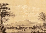
 Caburn has been a favourite subject of painters and illustrators for centuries.
East Sussex
East Sussex is a county in South East England. It is bordered by the counties of Kent, Surrey and West Sussex, and to the south by the English Channel.-History:...
, England
England
England is a country that is part of the United Kingdom. It shares land borders with Scotland to the north and Wales to the west; the Irish Sea is to the north west, the Celtic Sea to the south west, with the North Sea to the east and the English Channel to the south separating it from continental...
, about one mile (1.6 km) east of Lewes
Lewes
Lewes is the county town of East Sussex, England and historically of all of Sussex. It is a civil parish and is the centre of the Lewes local government district. The settlement has a history as a bridging point and as a market town, and today as a communications hub and tourist-oriented town...
overlooking the village of Glynde
Glynde
Glynde is a village in the Lewes District of East Sussex, United Kingdom. It is located two miles east of Lewes.-Estate:The estate at Glynde has belonged to four interlinked families: the Waleys , Morleys, Trevors, and Brands...
. It is an isolated part of the South Downs
South Downs
The South Downs is a range of chalk hills that extends for about across the south-eastern coastal counties of England from the Itchen Valley of Hampshire in the west to Beachy Head, near Eastbourne, East Sussex, in the east. It is bounded on its northern side by a steep escarpment, from whose...
, separated by Glynde Reach, a tributary of the River Ouse
River Ouse, Sussex
The River Ouse is a river in the counties of West and East Sussex in England.-Course:The river rises near Lower Beeding and runs eastwards into East Sussex, meandering narrowly and turning slowly southward...
.
Enclosure
On the summit of Caburn are the remains of an Iron AgeIron Age
The Iron Age is the archaeological period generally occurring after the Bronze Age, marked by the prevalent use of iron. The early period of the age is characterized by the widespread use of iron or steel. The adoption of such material coincided with other changes in society, including differing...
hill fort
Hill fort
A hill fort is a type of earthworks used as a fortified refuge or defended settlement, located to exploit a rise in elevation for defensive advantage. They are typically European and of the Bronze and Iron Ages. Some were used in the post-Roman period...
. The hill fort has been repeatedly excavated, by Augustus Pitt Rivers
Augustus Pitt Rivers
Lieutenant-General Augustus Henry Lane-Fox Pitt Rivers was an English army officer, ethnologist, and archaeologist. He was noted for his innovations in archaeological methods, and in the museum display of archaeological and ethnological collections.-Life and career:Born Augustus Henry Lane-Fox at...
(1877–78), the Curwens (1925—26), the Curwens again (1937–38), and latterly by the Sussex Archaeological Society
Sussex Archaeological Society
The Sussex Archaeological Society, founded in 1846, is the largest county-based archaeological society in the UK. Its headquarters are in Lewes, Sussex...
(1996–98). It may be the most excavated site in Britain, with no fewer than 170 trenches.
Pollen records (from peat at the southern base) indicate that prior to 2000 BC, the hill was covered with dark yew woodlands. The fact that a single Neolithic leaf-shaped arrowhead is the only pre-Bronze Age finding on Caburn, despite the extent and duration of excavations, suggests that there was little permanent occupation then.
The summit was initially enclosed in the middle Iron Age (c.400 BC), with a deep v-shaped ditch and a bank of dumped spoil. Originally the ditch was 8m wide at the top, 2.7m deep, and enclosed an area of 1.9 ha.
Since before the first excavations, it has been assumed that this enclosure was defensive, making a conventional hill fort
Hill fort
A hill fort is a type of earthworks used as a fortified refuge or defended settlement, located to exploit a rise in elevation for defensive advantage. They are typically European and of the Bronze and Iron Ages. Some were used in the post-Roman period...
. However the most recent excavators have challenged this assumption, arguing instead that the site was a religious enclosure, rather than a military fort or fortified farmstead. They point to the contents of the small pits, the insubstantial rampart, and its weak defensive attributes.
There are over 140 burial pits on Caburn; some are circular, some triangular and some rectangular. Each pit was found to be full of artefacts. Deposits included weapons, tools, pottery, coins, querns, and disarticulated human and animal bones. The most recent excavators argue that these are not random, or mere domestic rubbish, but are structured deposits and appear 'ritually charged'. The NE corner of the enclosure seemed to have special significance, because the high-status objects were mostly deposited there.
Outside the original rampart, on the northern side, there is a great ditch cut into the chalk. This is the side most vulnerable to attack.
This outer ditch has long been assumed to be a late Iron Age (re-)fortification, perhaps in response to the threat from Rome. That assumption has now been disproved. The excavation of trenches through the chalk dump (the spoil had been dumped in the adjacent valley instead of being used to build a bank) and a small internal bank turned up Romano-British pottery. Therefore the outer ditch is Romano-British or later, perhaps a Saxon measure against Viking raids.
Use
Caburn has only been reoccupied sporadically since the great northern ditch was built, at the Norman Conquest and during Stephen's reign.It appears that the Caburn was densely grazed during the Roman period, when the hill slopes around were a patchwork of rectangular ploughed fields. Then the hill probably returned to scrub. But by the Norman Conquest the Caburn was heavily grazed and the hill slopes were ploughed into strips. Both the Roman rectangular fields and the medieval strips are still visible today.
Over later centuries the dominant agricultural activity became sheep grazing. It was on Caburn and other local pastures that John Ellman
John Ellman
John Ellman was an English farmer and stock breeder who developed the Southdown breed of sheep.Ellman was born in Hartfield, Sussex, but moved with his family to Place Farm in Glynde in 1761...
reared his famous breed of Southdown sheep.
During the Second World War two slit trenches and a three-sided Bren position were dug into Caburn as part of a 'stop-line' to defend against invasion.
Conservation and recreation
Mount Caburn is now legally protected. It lies within the Lewes DownsLewes Downs
Lewes Downs is a 149.8 hectare biological Site of Special Scientific Interest in East Sussex, England. The site was notified in 1986 under the Wildlife and Countryside Act 1981....
SSSI (designated in 1953) and the Mount Caburn National Nature Reserve was established in the mid-1980s. It has been designated a Special Area of Conservation
Special Area of Conservation
A Special Area of Conservation is defined in the European Union's Habitats Directive , also known as the Directive on the Conservation of Natural Habitats and of Wild Fauna and Flora...
as an example of orchid-rich chalk grassland. It is home to a good population of stonechats.
Caburn is unusual within the South Downs for having a south-facing scarp slope. The site has the largest British population of burnt-tip orchid. There is also the rare small-leaved sweet-briar, and the typical fragrant and pyramidal orchids. Invertebrates include Adonis and chalk-hill blue butterflies and the scarce forester moth. Populations of stonechats live in scrubby bushes such as gorse
Gorse
Gorse, furze, furse or whin is a genus of about 20 plant species of thorny evergreen shrubs in the subfamily Faboideae of the pea family Fabaceae, native to western Europe and northwest Africa, with the majority of species in Iberia.Gorse is closely related to the brooms, and like them, has green...
near the golf club and in the valley below, along with other song birds such as blue tit
Blue Tit
The Blue Tit is a 10.5 to 12 cm long passerine bird in the tit family Paridae. It is a widespread and common resident breeder throughout temperate and subarctic Europe and western Asia in deciduous or mixed woodlands...
s. Herring gulls and carrion crows often fly overhead and hundreds of domestic sheep
Domestic sheep
Sheep are quadrupedal, ruminant mammals typically kept as livestock. Like all ruminants, sheep are members of the order Artiodactyla, the even-toed ungulates. Although the name "sheep" applies to many species in the genus Ovis, in everyday usage it almost always refers to Ovis aries...
graze the area. There is a sheltered cave with a water trough where lost sheep can rest safely if they stray away from the flock on a dark night when the farmer is rounding up the animals.
Caburn is a popular site for paragliding
Paragliding
Paragliding is the recreational and competitive adventure sport of flying paragliders: lightweight, free-flying, foot-launched glider aircraft with no rigid primary structure...
, being used when the wind is from south south-east to west-south-west.
Arts
In fiction Caburn appears as Wealden Hill in the novel of the same name by Graeme K TalboysGraeme K Talboys
Graeme K Talboys is an English writer and teacher.-Life:Talboys was born November 1953 at Queen Charlotte's Hospital, Hammersmith. His early life was lived on the edge of Richmond Park, before the family left London for Norwich. They then moved to Sussex where he spent his formative teenage years...
. Caburn also features prominently in the novels and short stories of John Whitbourn
John Whitbourn
John Whitbourn is an author and tenth-generation inhabitant of southern England's Downs Country. He has produced a variety of novels and short stories focusing on alternative histories set in a 'Catholic' universe...
(e.g.'The Royal Changeling' and 'Bury My Heart At Southerham (East Sussex)'. Caburn also appears in the children's story Elsie Piddock Skips in Her Sleep, (first published in 1937) by Eleanor Farjeon.
Name
It has only been called Mount Caburn since the end of the 18th century. The origins of the name are disputed.- It has long been suggested that Caburn may come from Caer Bryn (Welsh - Stronghold hill)
- A rival explanation is that it was originally Calde burgh (Old English - Cold Fort - 1296), then Mount Carbone (late 18th century).
- Some local accounts allege that by the 18th century it was called Carber, and before that it was called Calborough Hill.