
River Cuckmere
Encyclopedia
East Sussex
East Sussex is a county in South East England. It is bordered by the counties of Kent, Surrey and West Sussex, and to the south by the English Channel.-History:...
, England
England
England is a country that is part of the United Kingdom. It shares land borders with Scotland to the north and Wales to the west; the Irish Sea is to the north west, the Celtic Sea to the south west, with the North Sea to the east and the English Channel to the south separating it from continental...
on the southern slopes of the Weald
Weald
The Weald is the name given to an area in South East England situated between the parallel chalk escarpments of the North and the South Downs. It should be regarded as three separate parts: the sandstone "High Weald" in the centre; the clay "Low Weald" periphery; and the Greensand Ridge which...
. The name of the river probably comes from an Old English word meaning fast-flowing, since it descends over 100 m (328 ft) in its initial four miles (6.4 km). Eventually flowing into the English Channel
English Channel
The English Channel , often referred to simply as the Channel, is an arm of the Atlantic Ocean that separates southern England from northern France, and joins the North Sea to the Atlantic. It is about long and varies in width from at its widest to in the Strait of Dover...
, it is the only undeveloped river mouth on the Sussex coast.
Description
The river has many tributaries at its upper end, the principal one being the River Bull; and its main channel begins at HellinglyHellingly
Hellingly is a village and civil parish in the Wealden District of East Sussex, England. The village is located 1.5 miles north of Hailsham.The nearby village of Lower Dicker is located within the parish.-History:...
. After crossing the Low Weald area of farmland, the Cuckmere cuts through the South Downs
South Downs
The South Downs is a range of chalk hills that extends for about across the south-eastern coastal counties of England from the Itchen Valley of Hampshire in the west to Beachy Head, near Eastbourne, East Sussex, in the east. It is bounded on its northern side by a steep escarpment, from whose...
in its own valley
Cuckmere Valley
Cuckmere Valley is a civil parish in the Wealden District of East Sussex, England. As its name suggests, the parish consists of a number of small settlements in the lower reaches of the River Cuckmere.-The settlements:...
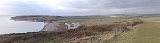
. It reaches the English Channel at Cuckmere Haven
Cuckmere Haven
Cuckmere Haven is an area of flood plains in Sussex, England where the river Cuckmere meets the English Channel between Eastbourne and Seaford. The river is an example of a meandering river, and contains several oxbow lakes...
, between Seaford
Seaford, East Sussex
Seaford is a coastal town in the county of East Sussex, on the south coast of England. Lying east of Newhaven and Brighton and west of Eastbourne, it is the largest town in Lewes district, with a population of about 23,000....
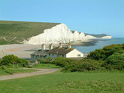
and the Seven Sisters
Seven Sisters, Sussex
The Seven Sisters are a series of chalk cliffs by the English Channel. They form part of the South Downs in East Sussex, between the towns of Seaford and Eastbourne in southern England. They are within the Seven Sisters Country Park...
cliff face. The lower part of its course in the floodplain
Floodplain
A floodplain, or flood plain, is a flat or nearly flat land adjacent a stream or river that stretches from the banks of its channel to the base of the enclosing valley walls and experiences flooding during periods of high discharge...
is marked by meander
Meander
A meander in general is a bend in a sinuous watercourse. A meander is formed when the moving water in a stream erodes the outer banks and widens its valley. A stream of any volume may assume a meandering course, alternately eroding sediments from the outside of a bend and depositing them on the...
ing, which is a well-known feature of the area. The Cuckmere Valley Nature Reserve is located in the lower estuary
Estuary
An estuary is a partly enclosed coastal body of water with one or more rivers or streams flowing into it, and with a free connection to the open sea....
portion of the river. The valley is of very high importance for nature conservation. It has been designated a Site of Special Scientific Interest
Site of Special Scientific Interest
A Site of Special Scientific Interest is a conservation designation denoting a protected area in the United Kingdom. SSSIs are the basic building block of site-based nature conservation legislation and most other legal nature/geological conservation designations in Great Britain are based upon...
and is planned as a National Park.
History and environmental issues
The Cuckmere ValleyCuckmere Valley
Cuckmere Valley is a civil parish in the Wealden District of East Sussex, England. As its name suggests, the parish consists of a number of small settlements in the lower reaches of the River Cuckmere.-The settlements:...
civil parish takes its name from the river. During the 19th century, defensive measures were taken to prevent flooding of the upper valley. Shingle was regularly dug from the mouth of the river and the banks were made higher. In 1846, the course of the river was straightened in an artificial cut; the Cut mostly prevented flooding upstream, which used to reach to the town of Alfriston
Alfriston
Alfriston is a village and civil parish in the East Sussex district of Wealden, England. The village lies in the valley of the River Cuckmere, about four miles north-east of Seaford and south of the main A27 trunk road and part of the large area of Polegate...
. It also provided support for irrigation. In addition, artificially higher river banks, or levees, were constructed to protect areas from flooding. In recent decades, the area has become a major tourist destination, with tourism contributing to the local economy more than does agriculture. On the west side of the river, where the A259
A259 road
The A259 is a busy road on the south coast of England passing through Hampshire, West Sussex, East Sussex and part of Kent. Part of the road was named "the most dangerous road in South East England" in 2008.-Description:...
crosses the river at Exceat, is the popular Golden Galleon Public House
Public house
A public house, informally known as a pub, is a drinking establishment fundamental to the culture of Britain, Ireland, Australia and New Zealand. There are approximately 53,500 public houses in the United Kingdom. This number has been declining every year, so that nearly half of the smaller...
.
In the last decade, the Cuckmere Estuary Partnership was established as a collaboration of the National Trust
National Trust for Places of Historic Interest or Natural Beauty
The National Trust for Places of Historic Interest or Natural Beauty, usually known as the National Trust, is a conservation organisation in England, Wales and Northern Ireland...
, Natural England, Environment Agency
Environment Agency
The Environment Agency is a British non-departmental public body of the Department for Environment, Food and Rural Affairs and an Assembly Government Sponsored Body of the Welsh Assembly Government that serves England and Wales.-Purpose:...
, East Sussex County Council, Sussex Wildlife Trust
Sussex Wildlife Trust
The Sussex Wildlife Trust is a wildlife trust and a registered charity covering the counties of East Sussex and West Sussex, England. The trust's Chief Executive is Tony Whitbread....
, and various other environmental and conservation groups. They are working together to create long-term plans for the natural area. Government guidelines prohibit continuing to maintain hard defences where houses are not at risk. In addition, there is growing scientific evidence that the area would be more ecologically rich if allowed to return to its natural state. The partnership and the Environment Agency have proposed estuary restoration, and have been talking to local residents, businesses and visitors about how to proceed in the future. Presently, a shingle beach and artificial river banks (levees) prevent seawater from penetrating the uppermost areas of the Cuckmere Valley. But, the Environment Agency projects that expected sea level rise due to climate change
Climate change
Climate change is a significant and lasting change in the statistical distribution of weather patterns over periods ranging from decades to millions of years. It may be a change in average weather conditions or the distribution of events around that average...
will increase the already steep costs of physical reinforcement, and current measures will not be sufficient. They intend to stop repair of the levees and to allow the cycle of natural processes, including periodic flooding of the area. The planning collaborators believe that in the long term, restoration of the saltwater estuary and marshes will enrich the ecological habitat, attract more wildlife and improve tourism.
The Environment Agency plans have provoked controversy in the valley, especially among some property owners. Some residents have formed a group called "Rescue the Cuckmere Valley" to try to create an alternative to proposed seasonal flooding. In early 2008 the Cuckmere Parish Council issued a public statement urging the Environment Agency to take less drastic steps in the near term, protecting the Cut while developing longer-term plans over the next 25–50 years.
External links
- "The Cuckmere Estuary", Cuckmere Estuary Partnership