
Greensand Ridge
Encyclopedia
The Greensand Ridge is an extensive, prominent, often heavily wooded, sandstone escarpment and range of hills in south-east England. It runs in a horseshoe shape around the Weald
of Surrey, Sussex and Kent. It reaches its highest elevation, 294 metres (965 ft), at Leith Hill
in Surrey—the second highest point in south-east England, while another hill, Blackdown
, is the highest point in Sussex
at 280 metres (919 ft). The eastern end of the ridge forms the northern boundary of Romney Marsh
.
that runs from south-east England into northern France.
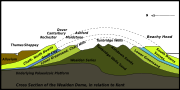
The Weald dome consists of a series of geological strata laid down in the Cretaceous
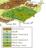
that have subsequently been lifted up, formed into a dome (ie anticline) and then deformed and faulted. The top-most and therefore youngest layer of the dome is Chalk
, laid down in the Upper Cretaceous. Below it lie successively older strata of alternating clays and sandstones laid down in the Lower Cretaceous, namely Upper Greensand, Gault Clay
, Lower Greensand, Weald Clay
and the Hastings Beds
. Differential fluvial erosion has virtually flattened the dome into a series of hills and vales. On the surface the strata of which the dome is composed crop out in a series of concentric circles, shaped like a horseshoe, with the more resistant chalk and sandstones forming hills and ridges (such as the Downs and High Weald), and the weaker clays forming vales (such as the Low Weald) between them. The very resistant rocks of the Lower Greensand, in particular the Hythe Beds, have produced prominent escarpments that form an arc around the northern edge of the Low Weald, running parallel to and just south of the chalk escarpment of the North Downs
. This stretch of the Greensand has become the most closely identified with the term "Greensand Ridge", and it includes the second highest point in south-east England, Leith Hill
in Surrey. West of the Weald the Lower Greensand has produced a more extensive area of hills and valleys, including the highest point in Sussex, Blackdown
. On the south side of the Weald the Lower Greensand also forms another arc of hills parallel to and just north of the South Downs
, becoming less prominent the further east one goes.
, but on exposure to the atmosphere this is rapidly oxidised to limonite, giving rise to a yellow or reddish brown staining.
The Lower Greensand is composed of alternating mudstones and sandstones, ranging up to a maximum thickness of about 400 metres (1,312.3 ft), and is composed of a number of distinct formations, namely the Folkestone Beds, Sandgate Beds, Bargate Beds, Hythe Beds and Atherfield Clay.
and stands of hazel
and oak
, while Scots Pine
and Birch
colonise the poorer soils.
, formed on Gault Clay, and a narrow band of Upper Greensand that outcrops at the foot of the chalk scarp. In some places the clay vale is very narrow: for example at Oxted the gap between the Greensand Ridge and the North Downs is less than 2 kilometres (1.2 mi).
The Greensand Ridge, capped by the resistant sands and sandstones of the Hythe Beds, reinforced by bands of chert
, rises steeply as a series of high, wooded escarpments between Gibbet Hill, Hindhead
(272 metres (892.4 ft)), north of Haslemere, and the ridge's highest point, Leith Hill
(294 metres (964.6 ft)). It then flattens for several miles, before re-emerging east of Nutfield to run eastwards as a high wooded ridge into an area between Oxted and Sevenoaks known locally as the Chartlands, where it reaches another high point at Toys Hill
, Kent (235 metres (771 ft)). Here there are stunning views to the south of the Weald from a terrace donated in 1898 by Octavia Hill
, one of the founders of the National Trust
. The ridge continues eastwards past Sevenoaks, until south-west of Maidstone
it is broken by the valley of the River Medway
. The ridge then continues as far as Pluckley
, Kent. From there the land levels until it drops to the old sea-cliff line above Romney Marsh.
In the area around Haslemere local anticlinal features are superimposed on the main axis of the Wealden anticline, causing the outcrop of resistant Hythe Beds to widen from 2 kilometres (1.2 mi) to more than 12 kilometres (7.5 mi) and to produce an escarpment that is particularly marked between Haslemere and Midhurst, where Blackdown
rises to 280 metres (918.6 ft), the highest point in Sussex. South of here the Vale of Fernhurst
has been eroded down into the Low Weald by what is now a small stream following a line of a gentle west-east trending upfold. This stream, the River Lod
, runs parallel to the larger River Rother
which flows about 10 km further south in the lee of the chalk escarpment of the South Downs. Valley slope processes in the Vale of Fernhurst have resulted in escarpments to the north and south that are steep enough to have collapsed by land slipping. Further east, the Lower Greensand has not produced any pronounced topographical features.
In many places along the escarpment of the Greensand Ridge erosion by wind and rain, landslips on the steep scarp face, and solifluction
in glacial times have further combined to create steep-side coombes, and low hillocks below the scarp.
The argument is as follows. The Jutes and Saxons who settled in south-east England in the centuries following the collapse of the Roman empire applied the term Weald (a Germanic term for woodland) to the very large, heavily wooded forest that they found lying inland of the coastal lands and river valleys that they initially settled. This forest, difficult to penetrate and settle, and difficult to exploit agriculturally, in due course became an essential part of a system of transhumance
whereby each autumn swine would be driven, sometimes over long distances, from the longer-settled areas on the periphery into the Wealden forest to feed on acorns of oak trees and beech mast. For these peoples the term Weald did not include the land cleared of forest and settled earlier, such as the fertile Vale of Holmesdale
(the valley which separates the North Downs from the Greensand Ridge), nor the more lightly wooded and open hills found on the sandstones of the Greensand Ridge, which also seem to have been settled earlier. Local people regarded the hills of the Greensand Ridge as overlooking the Weald, rather than forming a part of it, and hence a distinction came to be made between the settlements on the Greensand Ridge, such as Sevenoaks, Sundridge Upland and Boughton Malherbe Upland, and those formed during the later medieval colonisation of the Wealden portion of these parishes, called today Sevenoaks Weald, Sundridge Weald and Boughton Malherbe Weald.
The practice of treating the Greensand Ridge as part of the Weald appears to have arisen when natural scientists, starting in the late 18th century, began to include it in their analysis of the geological history of the Wealden dome. Today it has become almost routine to refer to the Weald as if it embraced all the land bounded by the chalk escarpments of the North and South Downs, including the Greensand hills.
, Surrey. In Surrey the Sandgate Beds and Bargate Beds, which lie on top of the Hythe Beds, have yielded a distinctive yellow stone seen in many local buildings. Ironstone, from layers embedded in the Sandgate Beds, is often seen in chips (gallets) pressed into the mortar between such stones. To the east, especially around Maidstone, Kent, the Hythe Beds yield a blue-grey sandstone with a high lime content. Known as ragstone, this is seen in many local buildings.
Fuller's earth
, which lies interbedded between the Bargate and Sandgate Layers, was much quarried for the cloth industry. The seam, which lies about 20 to 30 feet below the surface between Nutfield and Bletchingley, was considered the best in the country and for several centuries large quantities were excavated. Resources are now running low and little is now extracted.
(at the eastern end of the ridge) and Midhurst
. Petersfield
marks the western end, where the ridge turns north east. Settlements on the main part of the ridge, running from Surrey into Kent include Haslemere
, Godalming
, Reigate
and Redhill
, Oxted
and Sevenoaks
.
. Extending for 108 miles, it starts in the west at Haslemere
and ends in the east at Ham Street, Kent, on the edge of Romney Marsh. The route passes through or close to Godalming, Cranleigh
, Dorking
, Reigate, South Nutfield, Oxted, Westerham
, Sevenoaks
, Maidstone
and Ashford
.
. Much of the Greensand Ridge in Surrey lies within the Surrey Hills Area of Outstanding Natural Beauty
while a section of the Greensand hills in western Kent, from Limpsfield Chart near Westerham
through Sevenoaks to Plaxtol
, forms part of the Kent Downs Area of Outstanding Natural Beauty
, where it is known as the Sevenoaks Greensand Ridge.
Weald
The Weald is the name given to an area in South East England situated between the parallel chalk escarpments of the North and the South Downs. It should be regarded as three separate parts: the sandstone "High Weald" in the centre; the clay "Low Weald" periphery; and the Greensand Ridge which...
of Surrey, Sussex and Kent. It reaches its highest elevation, 294 metres (965 ft), at Leith Hill
Leith Hill
Leith Hill to the south west of Dorking, Surrey, England, reaches above sea level, the highest point on the Greensand Ridge, and is the second highest point in south-east England, after Walbury Hill near Hungerford, West Berkshire, high....
in Surrey—the second highest point in south-east England, while another hill, Blackdown
Blackdown, Sussex
Blackdown, or Black Down, is the highest hill in the historic county of Sussex, at 280 metres , and is second only to Leith Hill in southeastern England....
, is the highest point in Sussex
Sussex
Sussex , from the Old English Sūþsēaxe , is an historic county in South East England corresponding roughly in area to the ancient Kingdom of Sussex. It is bounded on the north by Surrey, east by Kent, south by the English Channel, and west by Hampshire, and is divided for local government into West...
at 280 metres (919 ft). The eastern end of the ridge forms the northern boundary of Romney Marsh
Romney Marsh
Romney Marsh is a sparsely populated wetland area in the counties of Kent and East Sussex in the south-east of England. It covers about 100 mi ² .-Quotations:*“As Egypt was the gift of the Nile, this level tract .....
.
Geology and soils
Geological history
The Greensand Ridge, formed of Lower Greensand sandstone, is a remnant of the Weald dome, part of the great Weald-Artois AnticlineWeald-Artois Anticline
The Weald–Artois anticline is a large anticline, a geological structure running between the regions of the Weald in southern England and the Artois in northeastern France. The fold formed during the Alpine orogeny, from the late Oligocene to middle Miocene as an uplifted form of the Weald basin...
that runs from south-east England into northern France.
The Weald dome consists of a series of geological strata laid down in the Cretaceous
Cretaceous
The Cretaceous , derived from the Latin "creta" , usually abbreviated K for its German translation Kreide , is a geologic period and system from circa to million years ago. In the geologic timescale, the Cretaceous follows the Jurassic period and is followed by the Paleogene period of the...
that have subsequently been lifted up, formed into a dome (ie anticline) and then deformed and faulted. The top-most and therefore youngest layer of the dome is Chalk
Chalk
Chalk is a soft, white, porous sedimentary rock, a form of limestone composed of the mineral calcite. Calcite is calcium carbonate or CaCO3. It forms under reasonably deep marine conditions from the gradual accumulation of minute calcite plates shed from micro-organisms called coccolithophores....
, laid down in the Upper Cretaceous. Below it lie successively older strata of alternating clays and sandstones laid down in the Lower Cretaceous, namely Upper Greensand, Gault Clay
Gault Clay
Gault is a clay formation of stiff blue clay deposited in a calm, fairly deep water marine environment during the Lower Cretaceous Period...
, Lower Greensand, Weald Clay
Weald Clay
Weald Clay is a Lower Cretaceous sedimentary rock underlying areas of South East England. It is part of the Wealden Group of rocks. The clay is named after the Weald, an area of Sussex. It varies from orange and grey in colour and is used in brickmaking....
and the Hastings Beds
Hastings Beds
The Hastings Beds is a geological formation in southeast England whose strata date back to the Early Cretaceous. Dinosaur remains are among the fossils that have been recovered from the formation.-Ornithischians:-Saurischians:-References:...
. Differential fluvial erosion has virtually flattened the dome into a series of hills and vales. On the surface the strata of which the dome is composed crop out in a series of concentric circles, shaped like a horseshoe, with the more resistant chalk and sandstones forming hills and ridges (such as the Downs and High Weald), and the weaker clays forming vales (such as the Low Weald) between them. The very resistant rocks of the Lower Greensand, in particular the Hythe Beds, have produced prominent escarpments that form an arc around the northern edge of the Low Weald, running parallel to and just south of the chalk escarpment of the North Downs
North Downs
The North Downs are a ridge of chalk hills in south east England that stretch from Farnham in Surrey to the White Cliffs of Dover in Kent. The North Downs lie within two Areas of Outstanding Natural Beauty , the Surrey Hills and the Kent Downs...
. This stretch of the Greensand has become the most closely identified with the term "Greensand Ridge", and it includes the second highest point in south-east England, Leith Hill
Leith Hill
Leith Hill to the south west of Dorking, Surrey, England, reaches above sea level, the highest point on the Greensand Ridge, and is the second highest point in south-east England, after Walbury Hill near Hungerford, West Berkshire, high....
in Surrey. West of the Weald the Lower Greensand has produced a more extensive area of hills and valleys, including the highest point in Sussex, Blackdown
Blackdown
- Places :In England:* Blackdown, Dorset, a village near Chard* Blackdown, Hampshire, a village near Winchester* Blackdown, West Sussex, a hill also spelt Black Down* Blackdown, Warwickshire, a village near Leamington Spa...
. On the south side of the Weald the Lower Greensand also forms another arc of hills parallel to and just north of the South Downs
South Downs
The South Downs is a range of chalk hills that extends for about across the south-eastern coastal counties of England from the Itchen Valley of Hampshire in the west to Beachy Head, near Eastbourne, East Sussex, in the east. It is bounded on its northern side by a steep escarpment, from whose...
, becoming less prominent the further east one goes.
Geology
The Lower Greensand is a predominantly arenaceous sandstone consisting of sediment that accumulated apparently in a shallow sea in the later part of the Lower Cretaceous. It also contains important subsidiary elements of silty and argillaceous material. Chert, ironstone and calcareous deposits occur in small amounts. When fresh the rocks have a greenish colouration owing to the presence of glauconiteGlauconite
Glauconite is an iron potassium phyllosilicate mineral of characteristic green color with very low weathering resistance and very friable.It crystallizes with a monoclinic geometry...
, but on exposure to the atmosphere this is rapidly oxidised to limonite, giving rise to a yellow or reddish brown staining.
The Lower Greensand is composed of alternating mudstones and sandstones, ranging up to a maximum thickness of about 400 metres (1,312.3 ft), and is composed of a number of distinct formations, namely the Folkestone Beds, Sandgate Beds, Bargate Beds, Hythe Beds and Atherfield Clay.
Soils
The soil of the Lower Greensand is quite varied, ranging from fertile to fairly sterile. On the fertile soils we see chestnutChestnut
Chestnut , some species called chinkapin or chinquapin, is a genus of eight or nine species of deciduous trees and shrubs in the beech family Fagaceae, native to temperate regions of the Northern Hemisphere. The name also refers to the edible nuts they produce.-Species:The chestnut belongs to the...
and stands of hazel
Hazel
The hazels are a genus of deciduous trees and large shrubs native to the temperate northern hemisphere. The genus is usually placed in the birch family Betulaceae, though some botanists split the hazels into a separate family Corylaceae.They have simple, rounded leaves with double-serrate margins...
and oak
Oak
An oak is a tree or shrub in the genus Quercus , of which about 600 species exist. "Oak" may also appear in the names of species in related genera, notably Lithocarpus...
, while Scots Pine
Scots Pine
Pinus sylvestris, commonly known as the Scots Pine, is a species of pine native to Europe and Asia, ranging from Scotland, Ireland and Portugal in the west, east to eastern Siberia, south to the Caucasus Mountains, and as far north as well inside the Arctic Circle in Scandinavia...
and Birch
Birch
Birch is a tree or shrub of the genus Betula , in the family Betulaceae, closely related to the beech/oak family, Fagaceae. The Betula genus contains 30–60 known taxa...
colonise the poorer soils.
Relief and drainage
Broadly speaking, the Greensand Ridge runs along the northern edge of the Weald in a west-east arc from Surrey into Kent, just south of and parallel to the chalk escarpment of the North Downs. The ridge is separated from the North Downs by a fertile vale, the Vale of HolmesdaleVale of Holmesdale
The Vale of Holmesdale is a comparatively narrow valley lying at the foot of the North Downs in Surrey and Kent, England. Its composition is mainly Gault Clay, although the Lower Chalk area at the foot of the Downs is included in the area. The River Medway, for part of its length, flows along the...
, formed on Gault Clay, and a narrow band of Upper Greensand that outcrops at the foot of the chalk scarp. In some places the clay vale is very narrow: for example at Oxted the gap between the Greensand Ridge and the North Downs is less than 2 kilometres (1.2 mi).
The Greensand Ridge, capped by the resistant sands and sandstones of the Hythe Beds, reinforced by bands of chert
Chert
Chert is a fine-grained silica-rich microcrystalline, cryptocrystalline or microfibrous sedimentary rock that may contain small fossils. It varies greatly in color , but most often manifests as gray, brown, grayish brown and light green to rusty red; its color is an expression of trace elements...
, rises steeply as a series of high, wooded escarpments between Gibbet Hill, Hindhead
Gibbet Hill, Hindhead
Gibbet Hill, at Hindhead, Surrey, is a hill above the Devil's Punch Bowl, not far from the A3 London to Portsmouth road in England. It is the second highest point in Surrey after Leith Hill....
(272 metres (892.4 ft)), north of Haslemere, and the ridge's highest point, Leith Hill
Leith Hill
Leith Hill to the south west of Dorking, Surrey, England, reaches above sea level, the highest point on the Greensand Ridge, and is the second highest point in south-east England, after Walbury Hill near Hungerford, West Berkshire, high....
(294 metres (964.6 ft)). It then flattens for several miles, before re-emerging east of Nutfield to run eastwards as a high wooded ridge into an area between Oxted and Sevenoaks known locally as the Chartlands, where it reaches another high point at Toys Hill
Toys Hill
Toys Hill is a hamlet in Brasted civil parish in the Sevenoaks district of Kent, England. It lies to the south of Brasted Chart, also in the parish. The hamlet is situated on the scarp slope of the Greensand Ridge, a high escarpment formed of Lower Greensand sandstone immediately north of the Weald...
, Kent (235 metres (771 ft)). Here there are stunning views to the south of the Weald from a terrace donated in 1898 by Octavia Hill
Octavia Hill
Octavia Hill was an English social reformer, whose main concern was the welfare of the inhabitants of cities, especially London, in the second half of the nineteenth century. Born into a family with a strong commitment to alleviating poverty, she herself grew up in straitened circumstances owing...
, one of the founders of the National Trust
National Trust for Places of Historic Interest or Natural Beauty
The National Trust for Places of Historic Interest or Natural Beauty, usually known as the National Trust, is a conservation organisation in England, Wales and Northern Ireland...
. The ridge continues eastwards past Sevenoaks, until south-west of Maidstone
Maidstone
Maidstone is the county town of Kent, England, south-east of London. The River Medway runs through the centre of the town linking Maidstone to Rochester and the Thames Estuary. Historically, the river was a source and route for much of the town's trade. Maidstone was the centre of the agricultural...
it is broken by the valley of the River Medway
Medway
Medway is a conurbation and unitary authority in South East England. The Unitary Authority was formed in 1998 when the City of Rochester-upon-Medway amalgamated with Gillingham Borough Council and part of Kent County Council to form Medway Council, a unitary authority independent of Kent County...
. The ridge then continues as far as Pluckley
Pluckley
Pluckley is a village and civil parish in the Ashford District of Kent, United Kingdom. It is located close to the North Downs, and is approximately 5 miles west of Ashford...
, Kent. From there the land levels until it drops to the old sea-cliff line above Romney Marsh.
In the area around Haslemere local anticlinal features are superimposed on the main axis of the Wealden anticline, causing the outcrop of resistant Hythe Beds to widen from 2 kilometres (1.2 mi) to more than 12 kilometres (7.5 mi) and to produce an escarpment that is particularly marked between Haslemere and Midhurst, where Blackdown
Blackdown
- Places :In England:* Blackdown, Dorset, a village near Chard* Blackdown, Hampshire, a village near Winchester* Blackdown, West Sussex, a hill also spelt Black Down* Blackdown, Warwickshire, a village near Leamington Spa...
rises to 280 metres (918.6 ft), the highest point in Sussex. South of here the Vale of Fernhurst
Fernhurst
Fernhurst is a village and civil parish in the Chichester District of West Sussex, England. It is located on the A286 Guildford to Chichester road, three miles south of Haslemere...
has been eroded down into the Low Weald by what is now a small stream following a line of a gentle west-east trending upfold. This stream, the River Lod
River Lod, West Sussex
The River Lod is a short river draining about of north west Sussex. The source is on Marley Heights near Haslemere, about 140 metres above sea level. From here it flows west past Linchmere, then south to Furnace Pond, where iron cannon were cast during the English Civil War...
, runs parallel to the larger River Rother
River Rother (Western)
The River Rother is a river which flows for thirty miles from Empshott in Hampshire to Stopham in West Sussex, where it joins the River Arun. It should not be confused with the River Rother, in East Sussex....
which flows about 10 km further south in the lee of the chalk escarpment of the South Downs. Valley slope processes in the Vale of Fernhurst have resulted in escarpments to the north and south that are steep enough to have collapsed by land slipping. Further east, the Lower Greensand has not produced any pronounced topographical features.
In many places along the escarpment of the Greensand Ridge erosion by wind and rain, landslips on the steep scarp face, and solifluction
Solifluction
In geology, solifluction, also known as soil fluction, is a type of mass wasting where waterlogged sediment moves slowly downslope, over impermeable material. It occurs in periglacial environments where melting during the warm season leads to water saturation in the thawed surface material ,...
in glacial times have further combined to create steep-side coombes, and low hillocks below the scarp.
Relationship to the Weald
It is common nowadays for the hills of the Greensand Ridge to be spoken of as if they formed part of the Weald. However, from a historical viewpoint, the Greensand Ridge is not a part of the Weald, but its border.The argument is as follows. The Jutes and Saxons who settled in south-east England in the centuries following the collapse of the Roman empire applied the term Weald (a Germanic term for woodland) to the very large, heavily wooded forest that they found lying inland of the coastal lands and river valleys that they initially settled. This forest, difficult to penetrate and settle, and difficult to exploit agriculturally, in due course became an essential part of a system of transhumance
Transhumance
Transhumance is the seasonal movement of people with their livestock between fixed summer and winter pastures. In montane regions it implies movement between higher pastures in summer and to lower valleys in winter. Herders have a permanent home, typically in valleys. Only the herds travel, with...
whereby each autumn swine would be driven, sometimes over long distances, from the longer-settled areas on the periphery into the Wealden forest to feed on acorns of oak trees and beech mast. For these peoples the term Weald did not include the land cleared of forest and settled earlier, such as the fertile Vale of Holmesdale
Vale of Holmesdale
The Vale of Holmesdale is a comparatively narrow valley lying at the foot of the North Downs in Surrey and Kent, England. Its composition is mainly Gault Clay, although the Lower Chalk area at the foot of the Downs is included in the area. The River Medway, for part of its length, flows along the...
(the valley which separates the North Downs from the Greensand Ridge), nor the more lightly wooded and open hills found on the sandstones of the Greensand Ridge, which also seem to have been settled earlier. Local people regarded the hills of the Greensand Ridge as overlooking the Weald, rather than forming a part of it, and hence a distinction came to be made between the settlements on the Greensand Ridge, such as Sevenoaks, Sundridge Upland and Boughton Malherbe Upland, and those formed during the later medieval colonisation of the Wealden portion of these parishes, called today Sevenoaks Weald, Sundridge Weald and Boughton Malherbe Weald.
The practice of treating the Greensand Ridge as part of the Weald appears to have arisen when natural scientists, starting in the late 18th century, began to include it in their analysis of the geological history of the Wealden dome. Today it has become almost routine to refer to the Weald as if it embraced all the land bounded by the chalk escarpments of the North and South Downs, including the Greensand hills.
Economic exploitation
The Folkestone Beds consist of seams of pebbles and sand. It is from here that the stone known as chert is found, familiar in the High Chart hills around LimpsfieldLimpsfield
Limpsfield is a village and parish in the east of the county of Surrey, England near Oxted at the foot of the North Downs. It lies between the A25 to the south and the M25 motorway to the north, near the Clackett Lane service station...
, Surrey. In Surrey the Sandgate Beds and Bargate Beds, which lie on top of the Hythe Beds, have yielded a distinctive yellow stone seen in many local buildings. Ironstone, from layers embedded in the Sandgate Beds, is often seen in chips (gallets) pressed into the mortar between such stones. To the east, especially around Maidstone, Kent, the Hythe Beds yield a blue-grey sandstone with a high lime content. Known as ragstone, this is seen in many local buildings.
Fuller's earth
Fuller's earth
Fuller's earth is any non-plastic clay or claylike earthy material used to decolorize, filter, and purify animal, mineral, and vegetable oils and greases.-Occurrence and composition:...
, which lies interbedded between the Bargate and Sandgate Layers, was much quarried for the cloth industry. The seam, which lies about 20 to 30 feet below the surface between Nutfield and Bletchingley, was considered the best in the country and for several centuries large quantities were excavated. Resources are now running low and little is now extracted.
Settlements
Principal settlements lying on the southern part of the Greensand in Sussex, adjacent to the South Downs, include StorringtonStorrington
Storrington is a village in the Horsham District of West Sussex, England, and one of two in the civil parish of Storrington and Sullington. Storrington lies at the foot of the north side of the South Downs. As of 2006 the village has a population of around 4,600. It has one main shopping street...
(at the eastern end of the ridge) and Midhurst
Midhurst
Midhurst is a market town and civil parish in the Chichester district of West Sussex, England, with a population of 4,889 in 2001. The town is situated on the River Rother and is home to the ruin of the Tudor Cowdray House and the stately Victorian Cowdray Park...
. Petersfield
Petersfield, Hampshire
Petersfield is a market town and civil parish in the East Hampshire district of Hampshire, England. It is north of Portsmouth, on the A3 road. The town has its own railway station on the Portsmouth Direct Line, the mainline rail link connecting Portsmouth and London. The town is situated on the...
marks the western end, where the ridge turns north east. Settlements on the main part of the ridge, running from Surrey into Kent include Haslemere
Haslemere
Haslemere is a town in Surrey, England, close to the border with both Hampshire and West Sussex. The major road between London and Portsmouth, the A3, lies to the west, and a branch of the River Wey to the south. Haslemere is approximately south-west of Guildford.Haslemere is surrounded by hills,...
, Godalming
Godalming
Godalming is a town and civil parish in the Waverley district of the county of Surrey, England, south of Guildford. It is built on the banks of the River Wey and is a prosperous part of the London commuter belt. Godalming shares a three-way twinning arrangement with the towns of Joigny in France...
, Reigate
Reigate
Reigate is a historic market town in Surrey, England, at the foot of the North Downs, and in the London commuter belt. It is one of the main constituents of the Borough of Reigate and Banstead...
and Redhill
Redhill
Redhill can refer to:* Redhill, South Australia, Australia* Redhill, Nottinghamshire, England* Redhill, Shropshire, England* Redhill, Somerset, England* Redhill, Surrey, England**Redhill railway station**Redhill Aerodrome* Redhill, Singapore, Singapore...
, Oxted
Oxted
Oxted is a commuter town in Surrey, England at the foot of the North Downs, north of East Grinstead and south-east of Croydon.- History :The town lay within the Anglo-Saxon administrative division of Tandridge hundred....
and Sevenoaks
Sevenoaks
Sevenoaks is a commuter town situated on the London fringe of west Kent, England, some 20 miles south-east of Charing Cross, on one of the principal commuter rail lines from the capital...
.
Recreation
Much of the ridge in Surrey and Kent is followed by a long-distance walking route, the Greensand WayGreensand Way
The Greensand Way is long distance walk of in southeast England, from Haslemere in Surrey to Hamstreet in Kent. It follows the Greensand Ridge along the Surrey Hills and Chart Hills. The route is mostly rural, passing through woods, and alongside fruit orchards and hop farms in Kent and links...
. Extending for 108 miles, it starts in the west at Haslemere
Haslemere
Haslemere is a town in Surrey, England, close to the border with both Hampshire and West Sussex. The major road between London and Portsmouth, the A3, lies to the west, and a branch of the River Wey to the south. Haslemere is approximately south-west of Guildford.Haslemere is surrounded by hills,...
and ends in the east at Ham Street, Kent, on the edge of Romney Marsh. The route passes through or close to Godalming, Cranleigh
Cranleigh
Cranleigh is a large village, self-proclaimed the largest in England, and is situated 8 miles south east of Godalming in Surrey. It lies to the east of the A281 which links Guildford with Horsham; neighbouring villages include: Ewhurst, Alfold and Hascombe....
, Dorking
Dorking
Dorking is a historic market town at the foot of the North Downs approximately south of London, in Surrey, England.- History and development :...
, Reigate, South Nutfield, Oxted, Westerham
Westerham
Westerham is a town and civil parish in the Sevenoaks District of Kent, in South East England with 5,000 people. The parish is south of the North Downs, ten miles west of Sevenoaks. It covers 5800 acres . It is recorded as early as the 9th century, and was mentioned in the Domesday Book in a...
, Sevenoaks
Sevenoaks
Sevenoaks is a commuter town situated on the London fringe of west Kent, England, some 20 miles south-east of Charing Cross, on one of the principal commuter rail lines from the capital...
, Maidstone
Maidstone
Maidstone is the county town of Kent, England, south-east of London. The River Medway runs through the centre of the town linking Maidstone to Rochester and the Thames Estuary. Historically, the river was a source and route for much of the town's trade. Maidstone was the centre of the agricultural...
and Ashford
Ashford, Kent
Ashford is a town in the borough of Ashford in Kent, England. In 2005 it was voted the fourth best place to live in the United Kingdom. It lies on the Great Stour river, the M20 motorway, and the South Eastern Main Line and High Speed 1 railways. Its agricultural market is one of the most...
.
Statutory designations
The south-west part of the Greensand ridge and hills is situated in the South Downs National ParkSouth Downs National Park
The South Downs National Park is England's newest National Park, having become fully operational on 1 April 2011. The park, covering an area of in southern England, stretches for from Winchester in the west to Eastbourne in the east through the counties of Hampshire, West Sussex and East Sussex...
. Much of the Greensand Ridge in Surrey lies within the Surrey Hills Area of Outstanding Natural Beauty
Surrey Hills AONB
The Surrey Hills is a Area of Outstanding Natural Beauty , located in Surrey, England. The AONB was designated in 1958 and covers one quarter of the county of Surrey...
while a section of the Greensand hills in western Kent, from Limpsfield Chart near Westerham
Westerham
Westerham is a town and civil parish in the Sevenoaks District of Kent, in South East England with 5,000 people. The parish is south of the North Downs, ten miles west of Sevenoaks. It covers 5800 acres . It is recorded as early as the 9th century, and was mentioned in the Domesday Book in a...
through Sevenoaks to Plaxtol
Plaxtol
Plaxtol is a small village of about 1,000 inhabitants in Kent. The River Bourne flows through the parish, and formerly powered three watermills in Plaxtol - Winfield Mill , Longmill and Roughway Paper Mill....
, forms part of the Kent Downs Area of Outstanding Natural Beauty
Kent Downs AONB
Kent Downs is an Area of Outstanding Natural Beauty in Kent, England . They are the eastern half of the North Downs and stretch from the London/Surrey borders to the White Cliffs of Dover...
, where it is known as the Sevenoaks Greensand Ridge.