
Legacy Parkway
Encyclopedia
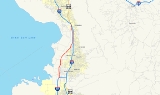
Legacy Parkway is a 11.5 miles (18.51 km) four-lane freeway completely within Davis County
in the northern part of the U.S. state
of Utah
, running from Interstate 215
in North Salt Lake to Interstate 15
and US-89
in Farmington
. Construction began in 2006 and was completed in 2008, with the freeway opening in September of that year. The highway was controversial in its building and was challenged in court several times before a compromise was met between the state and several environmental groups such as the Sierra Club
.
before turning northeasterly and north again, intersecting with 500 South at a diamond interchange
, which also provides a connection to Redwood Road (SR-68). The freeway continues north before beginning a curve to the northeast in West Bountiful
. Before reverting to its original northerly direction, the route intersects Parrish Lane (SR-105) at another diamond interchange. Past the intersection, the freeway parallels I-15 with Union Pacific and Utah Transit Authority
(FrontRunner
) railroad track in between. The highway, entering Farmington
, gains one lane in each direction and terminates at a dual junction with I-15 and US-89.
After a lawsuit that halted construction of the parkway over environmental concerns, the design of the road was re-envisioned to include extensive wetland protection west of the freeway and in the freeway median, a trail system along the side of the freeway, and numerous pedestrian overpasses and underpasses for ease of access to the trail system. Many of the architectural features were also specially-designed to give the freeway a more unique feel.
The Utah Department of Transportation
has designated the route as State Route 67 and has signed the route with SR-67 shields.
 Legacy Parkway is part of the larger Legacy Highway
project, which has aspirations of running from Nephi
in the south to Brigham City
, with the Parkway being only a portion in between. Although the concept of a western Davis County highway has existed since the 1960s, tentative construction of Legacy Parkway did not begin until 2004. However, it was forced to stop as a result of lawsuits over the completeness of the environmental impact statement
.
On September 21, 2005, the State of Utah
and the Sierra Club
(acting on behalf of numerous groups opposing the overall Legacy Highway project) officially signed a compromise regarding Legacy Parkway. Some of the agreements reached include no billboards
along the route, no truck
s allowed on the freeway (excepting cases where they are used in response to an accident or there is construction on I-15), and a 55 mph (90 km/h) speed limit. These restrictions hold until 2020.
Construction of the Parkway resumed in March 2006 with limited construction activity followed by heavy construction on the road beginning December 2006. Three contractors were hired to build the freeway; therefore, construction was divided into three segments: Segment one from I-215 in North Salt Lake to 500 South, segment two north to Glover Lane, and segment three north to I-15/US-89. The project reached the halfway point in October 2007. The highway opened September 13, 2008 at a cost of $685 million.
The route was designated a Utah Scenic Byway (as the Great Salt Lake Legacy Parkway Scenic Byway) on May 16, 2002.
{|class=wikitable
!Location
!Mile
!Exit
!Destinations
!Notes
|-
|North Salt Lake
|0.000
|1
|
|Southbound exit and northbound entrance
|-
|Woods Cross
|3.808-4.236
|4
|
|
|-
|Centerville
|7.176-7.664
|7
|Parrish Lane (SR-105
east)
|
|-
|rowspan=3|Farmington
|rowspan=3|11.500
|11
|
|Northbound exit and southbound entrance
|-
|12
|
|
|-
|13
|
|Northbound exit and southbound entrance
Davis County, Utah
Davis County is a county located in the U.S. state of Utah. As of 2010 the population was 306,479, a 28.2% increase over the 2000 figure of 238,994. It was named for Daniel C. Davis, captain in the Mormon Battalion. The county is part of the Ogden–Clearfield Metropolitan Statistical Area as...
in the northern part of the U.S. state
U.S. state
A U.S. state is any one of the 50 federated states of the United States of America that share sovereignty with the federal government. Because of this shared sovereignty, an American is a citizen both of the federal entity and of his or her state of domicile. Four states use the official title of...
of Utah
Utah
Utah is a state in the Western United States. It was the 45th state to join the Union, on January 4, 1896. Approximately 80% of Utah's 2,763,885 people live along the Wasatch Front, centering on Salt Lake City. This leaves vast expanses of the state nearly uninhabited, making the population the...
, running from Interstate 215
Interstate 215 (Utah)
Interstate 215 , also known locally as the belt route or two-fifteen, is an auxiliary interstate in the U.S. state of Utah that forms a 270-degree loop around Salt Lake City and many of its suburbs...
in North Salt Lake to Interstate 15
Interstate 15 in Utah
In the U.S. state of Utah, Interstate 15 runs north–south through the southwestern and central portions of the state, passing through many of the population centers of that state, including St. George, Provo, Salt Lake City, and Ogden, the latter three being part of the urban area known as...
and US-89
U.S. Route 89 in Utah
In the U.S. state of Utah, U.S. Route 89 is a long north–south state highway spanning more than through the central part of the state. Between Provo and Brigham City, US-89 serves as a local road, paralleling Interstate 15, but the portions from Arizona north to Provo and Brigham City...
in Farmington
Farmington, Utah
Farmington is a city in Davis County, Utah, United States. It is part of the Ogden–Clearfield, Utah Metropolitan Statistical Area. The population was 18,255 at the 2010 census. It is the county seat of Davis County...
. Construction began in 2006 and was completed in 2008, with the freeway opening in September of that year. The highway was controversial in its building and was challenged in court several times before a compromise was met between the state and several environmental groups such as the Sierra Club
Sierra Club
The Sierra Club is the oldest, largest, and most influential grassroots environmental organization in the United States. It was founded on May 28, 1892, in San Francisco, California, by the conservationist and preservationist John Muir, who became its first president...
.
Route description
The freeway begins at a partial interchange at I-215, allowing northbound motorists from the interstate to transfer onto Legacy Parkway and vice-versa. From the interchange, the highway heads northerly with two lanes in each direction through semi-rural western Davis CountyDavis County, Utah
Davis County is a county located in the U.S. state of Utah. As of 2010 the population was 306,479, a 28.2% increase over the 2000 figure of 238,994. It was named for Daniel C. Davis, captain in the Mormon Battalion. The county is part of the Ogden–Clearfield Metropolitan Statistical Area as...
before turning northeasterly and north again, intersecting with 500 South at a diamond interchange
Diamond interchange
A diamond interchange is a common type of road junction, used where a freeway crosses a minor road. The freeway itself is grade-separated from the minor road, one crossing the other over a bridge...
, which also provides a connection to Redwood Road (SR-68). The freeway continues north before beginning a curve to the northeast in West Bountiful
West Bountiful, Utah
West Bountiful is a city in Davis County, Utah, United States. It is part of the Ogden–Clearfield, Utah Metropolitan Statistical Area. The population was 5,265 at the 2010 census....
. Before reverting to its original northerly direction, the route intersects Parrish Lane (SR-105) at another diamond interchange. Past the intersection, the freeway parallels I-15 with Union Pacific and Utah Transit Authority
Utah Transit Authority
The Utah Transit Authority operates a public transportation system throughout the Wasatch Front of Utah, United States. It operates fixed route buses, express buses, ski buses, three light rail lines , and a commuter rail line from Salt Lake City to Pleasant View, north of Ogden. UTA is based in...
(FrontRunner
FrontRunner
FrontRunner is a commuter rail system operated by the Utah Transit Authority , serving the northern portion of the Wasatch Front from Salt Lake Central Station to Ogden Union Station. The system opened 26 April 2008...
) railroad track in between. The highway, entering Farmington
Farmington, Utah
Farmington is a city in Davis County, Utah, United States. It is part of the Ogden–Clearfield, Utah Metropolitan Statistical Area. The population was 18,255 at the 2010 census. It is the county seat of Davis County...
, gains one lane in each direction and terminates at a dual junction with I-15 and US-89.
After a lawsuit that halted construction of the parkway over environmental concerns, the design of the road was re-envisioned to include extensive wetland protection west of the freeway and in the freeway median, a trail system along the side of the freeway, and numerous pedestrian overpasses and underpasses for ease of access to the trail system. Many of the architectural features were also specially-designed to give the freeway a more unique feel.
The Utah Department of Transportation
Utah Department of Transportation
The Utah Department of Transportation is an agency of the state government for the U.S. state of Utah. The agency is usually referred to by its initials UDOT . UDOT is charged with maintaining the network of state highways in Utah. The agency is headquartered in the Calvin L. Rampton state office...
has designated the route as State Route 67 and has signed the route with SR-67 shields.
History
Legacy Highway
The Legacy Highway is a proposed freeway in the U.S. state of Utah that is planned to run from Brigham City in the north down the western side of the Wasatch Front to Nephi in the south. It was proposed in 1996, but due to lawsuits over issues with the completeness of the environmental impact...
project, which has aspirations of running from Nephi
Nephi, Utah
Nephi is a city in Juab County, Utah, United States. It is part of the Provo–Orem, Utah Metropolitan Statistical Area. The population was 4,733 at the 2000 census. It is the county seat of Juab County. It was settled by Mormon pioneers in 1851, and is the principal city in Juab Valley, an...
in the south to Brigham City
Brigham City, Utah
Brigham City is a city in Box Elder County, Utah, United States. The population was 17,899 at the 2010 census. It is the county seat of Box Elder County. It lies on the western slope of the Wellsville Mountains, a branch of the Wasatch Range at the western terminus of Box Elder Canyon...
, with the Parkway being only a portion in between. Although the concept of a western Davis County highway has existed since the 1960s, tentative construction of Legacy Parkway did not begin until 2004. However, it was forced to stop as a result of lawsuits over the completeness of the environmental impact statement
Environmental impact statement
An environmental impact statement , under United States environmental law, is a document required by the National Environmental Policy Act for certain actions "significantly affecting the quality of the human environment". An EIS is a tool for decision making...
.
On September 21, 2005, the State of Utah
Utah
Utah is a state in the Western United States. It was the 45th state to join the Union, on January 4, 1896. Approximately 80% of Utah's 2,763,885 people live along the Wasatch Front, centering on Salt Lake City. This leaves vast expanses of the state nearly uninhabited, making the population the...
and the Sierra Club
Sierra Club
The Sierra Club is the oldest, largest, and most influential grassroots environmental organization in the United States. It was founded on May 28, 1892, in San Francisco, California, by the conservationist and preservationist John Muir, who became its first president...
(acting on behalf of numerous groups opposing the overall Legacy Highway project) officially signed a compromise regarding Legacy Parkway. Some of the agreements reached include no billboards
Billboard (advertising)
A billboard is a large outdoor advertising structure , typically found in high traffic areas such as alongside busy roads. Billboards present large advertisements to passing pedestrians and drivers...
along the route, no truck
Truck
A truck or lorry is a motor vehicle designed to transport cargo. Trucks vary greatly in size, power, and configuration, with the smallest being mechanically similar to an automobile...
s allowed on the freeway (excepting cases where they are used in response to an accident or there is construction on I-15), and a 55 mph (90 km/h) speed limit. These restrictions hold until 2020.
Construction of the Parkway resumed in March 2006 with limited construction activity followed by heavy construction on the road beginning December 2006. Three contractors were hired to build the freeway; therefore, construction was divided into three segments: Segment one from I-215 in North Salt Lake to 500 South, segment two north to Glover Lane, and segment three north to I-15/US-89. The project reached the halfway point in October 2007. The highway opened September 13, 2008 at a cost of $685 million.
The route was designated a Utah Scenic Byway (as the Great Salt Lake Legacy Parkway Scenic Byway) on May 16, 2002.
Exit list
The entire route is in Davis County.{|class=wikitable
!Location
!Mile
!Exit
!Destinations
!Notes
|-
|North Salt Lake
|0.000
|1
|
|Southbound exit and northbound entrance
|-
|Woods Cross
|3.808-4.236
|4
|
|
|-
|Centerville
|7.176-7.664
|7
|Parrish Lane (SR-105
Utah State Route 105
Utah State Route 105 is a state highway in the U.S. state of Utah. It was created in 1965 to serve as a short connector route between Interstate 15 and SR-106 in downtown Centerville...
east)
|
|-
|rowspan=3|Farmington
|rowspan=3|11.500
|11
|
|Northbound exit and southbound entrance
|-
|12
|
|
|-
|13
|
|Northbound exit and southbound entrance