
Poulton-le-Fylde
Encyclopedia
Poulton-le-Fylde is a market town
in Lancashire
, England, situated on the coastal plain
called the Fylde
. As of the 2001 United Kingdom census
, it had a population of 18,264. There is evidence of human habitation in the area from 12,000 years ago and several archaeological finds from Roman settlement in England have been found in the area. At the time of the Norman conquest of England
Poulton was a small agricultural settlement in the hundred of Amounderness
. The church of St Chad
was recorded in 1094 when it was endowed to Lancaster Priory
. By the post-Medieval period the town had become an important commercial centre for the region with weekly and triannual markets. Goods were imported and exported through two harbours on the River Wyre
. In 1837, the town was described as the "metropolis of the Fylde", but its commercial importance waned from the mid-19th century with the development of the nearby coastal resorts of Fleetwood
and Blackpool
.
Poulton is the administrative centre of the borough of Wyre
and is in the parliamentary constituency of Wyre and Preston North
. It lies adjacent to the Blackpool Urban Area
and approximately 6.5 miles (10.5 km) from that town centre; there are rail links to Blackpool and Preston, and bus routes to the larger towns and villages of the Fylde. Poulton has a library and two secondary schools. There is a farmers' market
once a month and in 2011 plans were intiated for the reintroduction of the weekly market.
uncovered the 12,000 year-old skeleton of an elk
, along with two bone or antler barbed points close to its hind bones. At the time of the Roman conquest of Britain
in the 1st century AD, the area was inhabited by a Celtic
tribe called the Setantii
. A 4th-century hoard
of 400 Roman coins
was found in the area, near Fleetwood
. Other finds have been made in Poulton and Skippool; in addition to coins, these have included a medal of Germanicus
and a hipposandal
(similar to a horseshoe).
Although there is little archaeological evidence of Anglo-Saxon activity in the area following the departure of the Romans, local place names incorporate Old English elements like tūn (farmstead), suggesting that they were founded in that period. Nearby examples are Thornton
, Marton
and Carleton. Poulton was recorded in 1086 as Poltun; the name is derived from the Old English words pull or pōl + tūn meaning "farmstead by a pool or creek". In later years it was recorded variously as Pultun, Polton, Potton, Poolton and Poulton. The affix
le-Fylde ("in the district called the Fylde") was added in 1842 with the arrival of the Penny Post
, to distinguish the town from Poulton-le-Sands
, a village that is now part of Morecambe
.
Poulton is one of seven ancient parishes of the hundred of Amounderness
. Prior to the Norman conquest of England
in 1066, Amounderness was in the possession of Earl Tostig, the brother of King Harold II
. Tostig died at the Battle of Stamford Bridge
and his lands were subsequently taken over by the Normans. Between 1069 and 1086 William the Conqueror gave Amounderness to Anglo-Norman
baron Roger the Poitevin
. In the Domesday Book
of 1086 Poulton's area was estimated to contain two carucate
s of arable land. The survey recorded three churches in Amounderness though not by name. Later documentary evidence suggests that they were probably the churches at Poulton, Kirkham
and St Michael's on Wyre
. The dedication of Poulton's church
to 7th century Anglo-Saxon saint Chad of Mercia
lends weight to its pre-conquest foundation, although it is possible that it was built between 1086 and 1094.
In 1094, Roger the Poitevin founded the Benedictine
priory of St. Mary
at Lancaster
, as a cell of the Norman
Abbey of St. Martin in Sées
. He endowed the priory with the church and land at Poulton. Roger was eventually banished from the country and his lands returned to the possession of the Crown. In 1194 King Richard I
granted the hundred of Amounderness to Theobald Walter, 1st Baron Butler, who held it until his death in 1206. In 1268, King Henry III
granted the wapentake of Amounderness to his son Edmund Crouchback, who became the 1st Earl of Lancaster
around this time.
The amount of land in Poulton owned by St. Mary's Priory increased during the 12th and 13th centuries and caused conflict with local landowners over whose land the tenants and monks of the priory had to cross. In 1276, Sir Adam Banastre and his supporters assaulted the prior
, Ralph de Truno, as he travelled to Poulton. He and his attendants were taken by Banastre, beaten and imprisoned in Thornton. An investigation into the incident was instigated by the king; no record survives. In 1330, a compromise was made when two roads were built through Banastre's land which enabled the prior and his tenants to travel freely to Poulton. During the 13th and 14th centuries, much of the land at Poulton was given to Cockersand Abbey
in Lancaster and rented back to local farm workers. Much of the land in the Fylde was donated either to Cockersand Abbey or Whalley Abbey
. In order to efficiently manage and farm these lands, granges were built at Singleton
and Staining
. When the alien priories (those under control of religious houses abroad) were dissolved in 1415, the church at Poulton was conveyed to the Abbey of Syon in Middlesex.
In the 17th century Civil Wars
, townspeople of Poulton fought on both sides, although more men from the Fylde were on the side of the Royalists
. No battles occurred in or close to Poulton but the area was affected with the rest of the county by the widespread poverty that resulted from the wars. In 1643 interest was stirred in the parish when a large Spanish vessel dropped anchor off the coast at Rossall
. The ship made no movement for several days but fired its guns occasionally. Locals initially feared an invasion, but eventually realised that the crew was in distress and had been signalling for help. The vessel was carrying ammunition for the Parliamentarian
forces and the crew had become sick and feeble. The ship was brought by Royalists into the mouth of the River Wyre and the Earl of Derby
marched from across the River Ribble
. He ordered the ship to be burnt and the Spanish crew to be set free.
In the 18th century it was the custom for the wealthy in Poulton to bury their dead at night, following a lamp-lit procession through town. This tradition lasted until 1810. In 1732, during the procession preceding the funeral of Geoffrey Hornby, strong winds caused sparks to fly from the lighted tapers carried by mourners. The buildings on the west side of the market place, low cottages with thatched
roofs, caught fire and were destroyed. After local fund-raising the houses were eventually replaced with brick buildings with tile roofs.
, at Skippool and Wardleys, it was able to import goods from as far away as Russia and North America. Flax
was imported from Ireland and the Baltic
, timber came from across the Atlantic, and tallow
from Russia. Records from 1806–08 show that Poulton imported limestone
from Ulverston
, oats from Ulverston, Kirkcudbright
, Dumfries
, Wigtown
, Whitehaven
and Liverpool
, and coal from Preston. Cheese was exported to the same places. By the 18th century, markets for cattle and cloth were being held in the town in February, April and November, with corn fairs every Monday. It is unclear at what point Poulton began life as a market town; it was never granted a market charter and so markets were held by prescription. The market cross
probably dates from the 17th century.
The linen
industry was widespread in the Fylde during the 18th century and Poulton's importation of flax was essential. There were large warehouses at Skippool and Wardleys, owned by linen merchants from Kirkham. By the 19th century, craftsmen in Poulton were an important part of the industry. In the early part of the 19th century, there was a significant decline in the craft industries because of increased mechanisation, as well as increased demand for labour. In contrast to neighbouring Kirkham, Poulton appeared to suffer from a lack of enthusiasm for new industrial techniques and opportunities among its industry leaders.
Poulton's commercial importance was affected by the growth in the 19th century of two nearby coastal towns. In 1836 the first building was constructed in the new, planned town of Fleetwood
, 7 miles (11.3 km) north of Poulton, at the mouth of the River Wyre. Fleetwood was conceived by local landowner and Preston
Member of Parliament (MP) Sir Peter Hesketh-Fleetwood
as a major port and a link for passengers travelling from London to Scotland. To achieve these ideals, a rail link was needed and the new town soon heralded the arrival of the railway to the area. A line connecting Fleetwood with Preston was completed in 1840, with Poulton as one of the stops. Although Fleetwood immediately superseded Poulton as a port (the Customs House was quickly moved to Fleetwood), Poulton initially benefited commercially from the rail link. The importation of Irish and Scottish cattle through Fleetwood enabled a fortnightly cattle market to be held in Poulton. At the same time, Blackpool
was developing as a resort and for a few years visitors travelled by rail to Poulton and then on to Blackpool by horse-drawn charabanc
s or omnibuses. A line between Poulton and Blackpool was completed in 1846. As Fleetwood and Blackpool's own commercial capabilities developed, and Kirkham's prominence in the linen industry continued to grow, Poulton's importance declined.
hundred, an ancient division of the historic county of Lancashire, with a total area of 16691.5 acres (6,755 ha). The parish included the townships of Poulton, Carleton
, Thornton
, Hardhorn-With-Newton and Marton
. Poulton was governed by a parish council until 1900, when the parish was superseded by Poulton Urban District
. Today, with respect to civil parish
es, Poulton is unparished
. In 1974, following the Local Government Act 1972
, Poulton Urban District merged with those of Preesall
and Thornton-Cleveleys
, the municipal borough
of Fleetwood and the rural district
of Garstang
to form the borough
of Wyre
. The town is the borough's administrative centre, with its offices in Poulton Civic Centre.
The town is represented in the House of Commons
of the Parliament of the United Kingdom
as part of Wyre and Preston North
. It elects one MP by the first past the post system of election. Since its creation for the 2010 general election, Wyre and Preston North has been represented at Parliament by Conservative
MP Ben Wallace. Prior to the 2010 general election, Poulton-le-Fylde was part of the constituency of Lancaster and Wyre. The town is also part of the North West England constituency
of the European Parliament
.
, a coastal plain
that is approximately a 13 miles (20.9 km) square peninsula. The town is on flat, slightly raised ground, approximately 1 miles (2 km) from the River Wyre
and 3 miles (5 km) from the Irish Sea
. Until the 20th century, the town consisted of only a few streets surrounding the central market place; it became surrounded by housing developments from the end of the Second World War. The Poulton urban area
is adjacent to Carleton and Hardhorn, and close to the Blackpool Urban Area
. The land to the east of the town is mostly agricultural.
The bedrock
of the area consists of Permo
-Triassic
sandstone
s and particularly Triassic mudstone
s. These old rocks lie beneath sea-level and are invisible beneath drift
made up of glacial
till
deposits and post-glacial colluvium
and alluvium
deposits; there is a smaller amount of peat
.
Poulton has a generally temperate
maritime climate
like much of the British Isles
, with cool summers and mild winters. There is an annual average rainfall of 871.3 millimetres (34.3 in).
At the 2001 UK census
, the urban area
of Poulton-le-Fylde had a population of 18,264. The 2001 population density for Wyre
was 3.74 per hectare, with a 100 to 90.7 female-to-male ratio. The proportion of residents who classified themselves as White was 98.9%, a figure higher than the average for the North West (94.4%) and England (90.9%). Those classifying themselves as belonging to ethnic minorities were correspondingly lower than the regional and national averages. Of those over 16 years old, 22.5% were single (never married), 46.0% married and 8.49% divorced. Although the proportion of divorced people was similar to that of the North West and England, the rates of those who were married were higher than the regional and national averages (North West: 42.8%; England: 43.5%). The rates of those in Wyre who were single were significantly lower than the national and regional averages (North West: 30.1%; England: 30.2%).
Wyre's 45,295 households included 29.1% one-person, 37.3% married couples living together, 6.8% co-habiting
couples, and 9.0% single parents with their children; these figures were similar to those of the North West and England. Of those aged 16–74, 31.1% had no academic qualifications, similar to that of 31.9% in all of the North West but higher than 28.9% in all of England. Wyre had a lower percentage of adults with a diploma or degree than the North West as a whole. Of Wyre residents aged 16–74, 15.7% had an educational qualification such as first degree, higher degree, qualified teacher status, qualified medical doctor, qualified dentist, qualified nurse, midwife, or health visitor, compared to 17.2% in the North West and 19.9% nationwide.
In the 13th century, Poulton's economy was largely agricultural. Over the next centuries, the town became a commercial centre for the area, importing and exporting goods through harbours on the River Wyre at Skippool and Wardleys. Imports of flax were vital for a local linen industry, particularly in nearby Kirkham, and Poulton craftsmen were part of this industry by the beginning of the 19th century. During the early part of this century the changes brought by the industrial revolution
led to a decline in the craft industries in Poulton. New methods were not embraced by local producers and the town suffered from its location, far from coalfields and large labour markets. Following the development of the new town and port of Fleetwood
from 1836, Poulton's role as a major commerce centre waned. For some time, the town's market remained important as a local supply of goods for growing Fleetwood and Blackpool. Eventually Poulton was overshadowed by Fleetwood and Blackpool. In his 1837 work on Blackpool, William Thornber called Poulton the "metropolis of the Fylde". This was a time when Poulton was still prominent among its near neighbours; David Foster commented in 1972 that not only was Thornber's description of the town no longer apt, it had ceased to be accurate even from 1850 with the rapid growth of the coastal resorts.
Although the unemployment rate in Wyre is higher than that of the North West and England, in 2004 a Market Town Initiative study noted that the level of unemployment in Poulton was lower than the regional and national averages, at 1.41%. Business in the town is centred at the Poulton Industrial Estate. Agriculture is still important locally; in 2001 2.6% of workers in Wyre were employed in agriculture, hunting or forestry (compared to 1.2% in the North West and 1.5% in England).
's Market Town Initiative. Their Health Check and Action Plan identified "economic, transport & accessibility, environmental and social strengths and weaknesses" of Poulton. The study noted that the town has no cinemas, theatres, museums or galleries and that there was popular demand for a cinema, a weekly market and more independent retailers. There was also concern among residents that there are not enough facilities for young people. Poulton has a library, operated by Lancashire County Council
.
Poulton's public spaces include the Jean Stansfield Memorial and Vicarage Park, Tithebarn Park and the Cottam Hall Playing Fields. The Jean Stansfield Memorial and Vicarage Park is close to the town centre. It was built in 1955 on the grounds of the town's former vicarage, sold to Poulton Council in 1951. In 1926, the park was enlarged when the parents of Jean Stansfield, a child who had died at the age of 10, donated 2 acre (0.809372 ha) of land to the town in her memory. The park includes a Crown Green bowling green
and a skate park. Tithebarn Park, north-west of the town centre, was built on the site of a former railway halt, Poulton Curve
. It features grass play areas. The Cottam Hall Playing Fields to the west of the town centre include sports pitches and allotment
s. There is a cricket
ground to the north-east of the town. Poulton includes part of the Wyre Way footpath
.
Poulton Gala is held annually in June and a farmers' market
is held on the fourth Saturday of every month. In October 2011, Wyre Borough Council introduced the first of what the council hopes to be a return of the town's weekly market.
since 1979 and 15 buildings and structures in the town have been designated as listed buildings by English Heritage
for their special architectural, historical or cultural significance. These include two religious buildings, the structures in the market place and several houses.
The market place at the centre of Poulton is the width of two streets and is now closed to motor traffic. Lying south of St Chad's Church and surrounded by shops, the square contains the town's war memorial as well as a market cross
, stocks
, whipping post and fish slabs, from which fish were sold on market days. Although many of the buildings surrounding the market place were rebuilt following a fire in the 18th century, a few of the earlier buildings remain. To the south of the market place are town houses that were built for local merchants and professionals.
Public house
s and inns flourished early on in Poulton due to its status as a market town. One of the most important inns was the Golden Ball, which probably dates from the 18th century. It was also the meeting place of the local court, and at the end of the 19th century the town's cattle market was moved behind the pub from the market place. The Thatched House pub existed in 1793 and may have been built in the Middle Ages
. It was rebuilt in 1910 in the Mock Tudor style and has been identified as one of the town's "key landmarks" by the Poulton Market Town Initiative. In the 19th century the Ship Inn was a rowdy pub popular with Fleetwood seamen, travelling labourers and locals. In the 1920s it became a working men's club
and from 1928–2001, a conservative club
. It is an Edwardian
building constructed in red brick with red sandstone
dressings. It has a corner tower and the walls have carvings of ships. it is a pub and nightclub called The Cube.
, the Anglican
parish church
, is in the centre of town, bordering the market place. It has been designated a Grade II* listed building by English Heritage
. The current structure dates largely from the mid-18th century when the previous church was demolished, although the tower is from the 17th century. The church is constructed of stone and has a slate
roof. A round Norman
-style apse
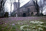
was added in 1868. The churchyard, mainly to the south and east of the building, is noted for its display of crocuses in the spring.
After the English Reformation
there remained a strong Roman Catholic influence in the parish, with worship particularly focused in Singleton
. In the late 16th century there were 13 houses in the parish that were known to shelter seminarians. In 1583, the family of Cardinal William Allen, a prominent opponent of the Reformation, were holding three or four masses daily at their home at nearby Rossall
. In the early 19th century, a Roman Catholic chapel was built in the town of Poulton. St John the Evangelist's
was built in the north of the town, on Breck Road. The building, with its attached presbytery
is constructed of rendered
brick with a slate roof and has been designated a Grade II listed building. Tradition has it that at some time during the 19th century, the vicar of St. Chad's donated to that church a particularly "papist" vestment
. The chapel was replaced by a larger church built a few metres to the south in 1912. The new building, constructed of rock-faced red sandstone
in a stripped Romanesque
style, was designed by Cuthbert Pugin of Pugin & Pugin
.
The first establishment of nonconformist
s in Poulton were the Methodists
, in 1784. The group met in a room behind the King's Arms and initially suffered persecution from other locals. They built a chapel in what is now Church Street in 1819, the second Methodist chapel to be built on the Fylde. The chapel was enlarged in 1861 and 1909 and finally demolished in 1970, replaced by a new chapel in Queen Street. The Congregational church
established a chapel in the town in 1809. Its use was intermittent and at one point the building was used as a warehouse. A new chapel was built in 1899.
In the 2001 census 83.06% of respondents in Wyre gave their religion as Christianity. This is higher than the average for the North West (78.01%) and England (71.74). Muslim residents made up 0.18% of respondents in Wyre, 0.15% were Buddhist, 0.14% were Hindu, 0.10% were Jewish and 0.05% were Sikh; these figures are all lower than the regional and national averages. A further 9.40% of people in the borough stated that they had no religion, also a lower figure than the regional and national averages.
, on the line between Kirkham
and Fleetwood
was originally situated at the bottom of the Breck, the road leading north out of Poulton. A branch connecting Poulton to Blackpool opened in 1846. The Fleetwood Branch Line
closed to passengers in 1970. By 1892, a particularly tight bend in the line near Poulton's station meant that plans were underway to realign the tracks and rebuild the station at the top of the Breck. The fears of local people were realised in 1893 when a train travelling too fast derailed at the bend, killing three people. The new station was built in 1896. A railway halt called Poulton Curve
was built in 1923 and was in use until 1952. Today, Poulton is a stop on the Caldervale Line
and the Blackpool Branch Line
. It lies between Kirkham and Wesham
(towards Preston
) and Layton
(towards Blackpool North
). In 2009, a report by the Association of Train Operating Companies
suggested that there would be a "strong business case" to reopen the line between Poulton and Fleetwood.
Poulton is approximately 13 miles (20.9 km) east of the M6 motorway
and is linked to it by the M55
at Greenhalgh and by the A586 and A6 via Broughton
. There are A roads
to Fleetwood, Blackpool and Preston. Poulton is served by three bus companies; Blackpool Transport
, Stagecoach
and Cumfybus
provide links to the Fylde's coastal towns as well as villages across the River Wyre, and Preston.
Poulton's nearest international airport—approximately 6.5 miles away—is Blackpool International Airport which has an annual capacity of 350,000 passengers. The North West
region is also served by the larger Liverpool John Lennon Airport
and Manchester Airport.
s, the oldest of which dates from the 18th century. In 1717, local woollen merchant James Baines left money in his will to found three free schools in the parish; in Poulton, Marton and Thornton. All three still exist. Baines School
in Poulton was rebuilt in 1828 and closed temporarily in the late 19th century, reopening as Baines Endowed School. Today it is a voluntary aided
non-denominational comprehensive
secondary school and sixth form
. It has 1,008 pupils aged 11–18 and was rated as "good" in its 2007 Ofsted
report. Hodgson School is a comprehensive secondary school and Technology College
that opened in 1932. It has 1,108 pupils aged 11–16 and in 2008 was rated by Ofsted as "outstanding".
There are four primary schools in the town; The Breck Primary School, St John's Catholic Primary School, Carr Head Primary School and St Chad's Church of England Primary School. All were rated either "good" or "outstanding" in their most recent Ofsted inspections.
and sewerage
facilities are provided by United Utilities
. The distribution network operator
for electricity is Electricity North West
. Home Office
policing is provided by Lancashire Constabulary
. There is one police station in Poulton.
National health services
are provided by NHS North West
and primary care
is delivered by the NHS North Lancashire Primary Care Trust. In 2004, the Poulton Market Town Initiative noted 11 general practices in the town (including Carleton). Secondary care is provided by the Blackpool, Fylde and Wyre Hospitals NHS Foundation Trust
. Acute medical cases are handled by Victoria Hospital
in Blackpool and the North West Ambulance Service
provides emergency patient transport.
Market town
Market town or market right is a legal term, originating in the medieval period, for a European settlement that has the right to host markets, distinguishing it from a village and city...
in Lancashire
Lancashire
Lancashire is a non-metropolitan county of historic origin in the North West of England. It takes its name from the city of Lancaster, and is sometimes known as the County of Lancaster. Although Lancaster is still considered to be the county town, Lancashire County Council is based in Preston...
, England, situated on the coastal plain
Coastal plain
A coastal plain is an area of flat, low-lying land adjacent to a seacoast and separated from the interior by other features. One of the world's longest coastal plains is located in eastern South America. The southwestern coastal plain of North America is notable for its species diversity...
called the Fylde
The Fylde
The Fylde ; Scandinavian: "field") is a coastal plain in western Lancashire, England. It is roughly a 13-mile square-shaped peninsula, bounded by Morecambe Bay to the north, the Ribble estuary to the south, the Irish Sea to the west, and the Bowland hills to the east...
. As of the 2001 United Kingdom census
United Kingdom Census 2001
A nationwide census, known as Census 2001, was conducted in the United Kingdom on Sunday, 29 April 2001. This was the 20th UK Census and recorded a resident population of 58,789,194....
, it had a population of 18,264. There is evidence of human habitation in the area from 12,000 years ago and several archaeological finds from Roman settlement in England have been found in the area. At the time of the Norman conquest of England
Norman conquest of England
The Norman conquest of England began on 28 September 1066 with the invasion of England by William, Duke of Normandy. William became known as William the Conqueror after his victory at the Battle of Hastings on 14 October 1066, defeating King Harold II of England...
Poulton was a small agricultural settlement in the hundred of Amounderness
Amounderness
Amounderness was a hundred of Lancashire in North West England. Formerly, the name had been used for territories now in Lancashire and north of the River Ribble that had been included in Domesday Yorkshire.-Etymology and history:...
. The church of St Chad
St Chad's Church, Poulton-le-Fylde
St Chad's Church is an Anglican church in Poulton-le-Fylde, a town on the Fylde coastal plain in Lancashire, England. It is an active parish church in the Diocese of Blackburn and the archdeaconry of Lancaster. It has been designated a Grade II* listed building by English Heritage...
was recorded in 1094 when it was endowed to Lancaster Priory
Lancaster Priory
Lancaster Priory, formerly St Mary's Church, Lancaster, is the parish church of the city of Lancaster, Lancashire, England. It is located near Lancaster Castle and has been designated by English Heritage as a Grade I listed building. It is an active Anglican church in the deanery of...
. By the post-Medieval period the town had become an important commercial centre for the region with weekly and triannual markets. Goods were imported and exported through two harbours on the River Wyre
River Wyre
The River Wyre is a river in Lancashire, United Kingdom, which flows into the Irish Sea at Fleetwood. It is approximately 28 miles in length...
. In 1837, the town was described as the "metropolis of the Fylde", but its commercial importance waned from the mid-19th century with the development of the nearby coastal resorts of Fleetwood
Fleetwood
Fleetwood is a town within the Wyre district of Lancashire, England, lying at the northwest corner of the Fylde. It had a population of 26,840 people at the 2001 Census. It forms part of the Greater Blackpool conurbation. The town was the first planned community of the Victorian era...
and Blackpool
Blackpool
Blackpool is a borough, seaside town, and unitary authority area of Lancashire, in North West England. It is situated along England's west coast by the Irish Sea, between the Ribble and Wyre estuaries, northwest of Preston, north of Liverpool, and northwest of Manchester...
.
Poulton is the administrative centre of the borough of Wyre
Wyre
Wyre is a local government district with borough status in Lancashire, England. Its council is based in Poulton-le-Fylde.The district is named after the River Wyre, which runs through the district...
and is in the parliamentary constituency of Wyre and Preston North
Wyre and Preston North (UK Parliament constituency)
Wyre and Preston North is a county constituency represented in the House of Commons of the Parliament of the United Kingdom. Created in the most recent fifth periodic review of constituencies by the Boundary Commission for England, it elects one Member of Parliament by the first past the post...
. It lies adjacent to the Blackpool Urban Area
Blackpool Urban Area
Greater Blackpool is the informal name for the urban area surrounding Blackpool in Lancashire, England. The ONS define a Blackpool Urban Area, with a population of 261,088 , down 0.1% from the 1991 figure of 261,355....
and approximately 6.5 miles (10.5 km) from that town centre; there are rail links to Blackpool and Preston, and bus routes to the larger towns and villages of the Fylde. Poulton has a library and two secondary schools. There is a farmers' market
Farmers' market
A farmers' market consists of individual vendors—mostly farmers—who set up booths, tables or stands, outdoors or indoors, to sell produce, meat products, fruits and sometimes prepared foods and beverages...
once a month and in 2011 plans were intiated for the reintroduction of the weekly market.
Early history
There is evidence of human habitation in the area around Poulton from 10,000 BC. In 1970 building work in nearby CarletonCarleton, Lancashire
Carleton is a village on the coastal plain of the Fylde in Lancashire, England. It consists of Great Carleton, Little Carleton and Norcross and is situated close to the market town of Poulton-le-Fylde. Nearby settlements include Thornton, Bispham and Blackpool...
uncovered the 12,000 year-old skeleton of an elk
Irish Elk
The Irish Elk or Giant Deer , was a species of Megaloceros and one of the largest deer that ever lived. Its range extended across Eurasia, from Ireland to east of Lake Baikal, during the Late Pleistocene. The latest known remains of the species have been carbon dated to about 7,700 years ago...
, along with two bone or antler barbed points close to its hind bones. At the time of the Roman conquest of Britain
Roman conquest of Britain
The Roman conquest of Britain was a gradual process, beginning effectively in AD 43 under Emperor Claudius, whose general Aulus Plautius served as first governor of Britannia. Great Britain had already frequently been the target of invasions, planned and actual, by forces of the Roman Republic and...
in the 1st century AD, the area was inhabited by a Celtic
Britons (historical)
The Britons were the Celtic people culturally dominating Great Britain from the Iron Age through the Early Middle Ages. They spoke the Insular Celtic language known as British or Brythonic...
tribe called the Setantii
Setantii
The Setantii were a pre-Roman British tribe who apparently lived in the western and southern littoral of Lancashire in England...
. A 4th-century hoard
Hoard
In archaeology, a hoard is a collection of valuable objects or artifacts, sometimes purposely buried in the ground. This would usually be with the intention of later recovery by the hoarder; hoarders sometimes died before retrieving the hoard, and these surviving hoards may be uncovered by...
of 400 Roman coins
Roman currency
The Roman currency during most of the Roman Republic and the western half of the Roman Empire consisted of coins including the aureus , the denarius , the sestertius , the dupondius , and the as...
was found in the area, near Fleetwood
Fleetwood
Fleetwood is a town within the Wyre district of Lancashire, England, lying at the northwest corner of the Fylde. It had a population of 26,840 people at the 2001 Census. It forms part of the Greater Blackpool conurbation. The town was the first planned community of the Victorian era...
. Other finds have been made in Poulton and Skippool; in addition to coins, these have included a medal of Germanicus
Germanicus
Germanicus Julius Caesar , commonly known as Germanicus, was a member of the Julio-Claudian dynasty and a prominent general of the early Roman Empire. He was born in Rome, Italia, and was named either Nero Claudius Drusus after his father or Tiberius Claudius Nero after his uncle...
and a hipposandal
Hipposandal
The Hipposandal is a device that protected the hoof of a horse. It was commonplace in the countries of the Roman Empire and was a predecessor to the horseshoe....
(similar to a horseshoe).
Although there is little archaeological evidence of Anglo-Saxon activity in the area following the departure of the Romans, local place names incorporate Old English elements like tūn (farmstead), suggesting that they were founded in that period. Nearby examples are Thornton
Thornton, Lancashire
Thornton is a village on the Fylde, in Lancashire, England, about four miles north of Blackpool and two miles south of Fleetwood. It is in the Borough of Wyre...
, Marton
Marton, Blackpool
Marton is a settlement on the coastal plain of the Fylde in Lancashire, England, most of which is now part of the seaside town of Blackpool. Marton, which consisted of Great Marton, Little Marton, Marton Fold and The Peel, was originally part of the parish of Poulton-le-Fylde, before the...
and Carleton. Poulton was recorded in 1086 as Poltun; the name is derived from the Old English words pull or pōl + tūn meaning "farmstead by a pool or creek". In later years it was recorded variously as Pultun, Polton, Potton, Poolton and Poulton. The affix
Affix
An affix is a morpheme that is attached to a word stem to form a new word. Affixes may be derivational, like English -ness and pre-, or inflectional, like English plural -s and past tense -ed. They are bound morphemes by definition; prefixes and suffixes may be separable affixes...
le-Fylde ("in the district called the Fylde") was added in 1842 with the arrival of the Penny Post
Penny Post
The Penny Post is any one of several postal systems in which normal letters could be sent for one penny.-London Penny Post:In England, the Post Office had a monopoly on the collection and carriage of letters between post towns but there was no delivery system until the London Penny Post was...
, to distinguish the town from Poulton-le-Sands
Poulton-le-Sands
Poulton-le-Sands was one of three small villages that combined to create Morecambe. Poulton was first mentioned in the Domesday Book as Poltune. It later became Poulton and remained this way for a number of centuries. It was towards the end of the eighteenth or the beginning of the nineteenth...
, a village that is now part of Morecambe
Morecambe
Morecambe is a resort town and civil parish within the City of Lancaster in Lancashire, England. As of 2001 it has a resident population of 38,917. It faces into Morecambe Bay...
.
Poulton is one of seven ancient parishes of the hundred of Amounderness
Amounderness
Amounderness was a hundred of Lancashire in North West England. Formerly, the name had been used for territories now in Lancashire and north of the River Ribble that had been included in Domesday Yorkshire.-Etymology and history:...
. Prior to the Norman conquest of England
Norman conquest of England
The Norman conquest of England began on 28 September 1066 with the invasion of England by William, Duke of Normandy. William became known as William the Conqueror after his victory at the Battle of Hastings on 14 October 1066, defeating King Harold II of England...
in 1066, Amounderness was in the possession of Earl Tostig, the brother of King Harold II
Harold Godwinson
Harold Godwinson was the last Anglo-Saxon King of England.It could be argued that Edgar the Atheling, who was proclaimed as king by the witan but never crowned, was really the last Anglo-Saxon king...
. Tostig died at the Battle of Stamford Bridge
Battle of Stamford Bridge
The Battle of Stamford Bridge took place at the village of Stamford Bridge, East Riding of Yorkshire in England on 25 September 1066, between an English army under King Harold Godwinson and an invading Norwegian force led by King Harald Hardrada of Norway and the English king's brother Tostig...
and his lands were subsequently taken over by the Normans. Between 1069 and 1086 William the Conqueror gave Amounderness to Anglo-Norman
Anglo-Norman
The Anglo-Normans were mainly the descendants of the Normans who ruled England following the Norman conquest by William the Conqueror in 1066. A small number of Normans were already settled in England prior to the conquest...
baron Roger the Poitevin
Roger the Poitevin
Roger the Poitevin was born in Normandy in the mid-1060s and died before 1140 . He was an Anglo-Norman aristocrat, who possessed large holdings in both England and through his marriage in France....
. In the Domesday Book
Domesday Book
Domesday Book , now held at The National Archives, Kew, Richmond upon Thames in South West London, is the record of the great survey of much of England and parts of Wales completed in 1086...
of 1086 Poulton's area was estimated to contain two carucate
Carucate
The carucate or ploughland was a unit of assessment for tax used in most Danelaw counties of England, and is found for example in Domesday Book. The carucate was based on the area a plough team of eight oxen could till in a single annual season...
s of arable land. The survey recorded three churches in Amounderness though not by name. Later documentary evidence suggests that they were probably the churches at Poulton, Kirkham
Kirkham, Lancashire
Kirkham, or as it once was known, Kirkam-in-Amounderness is a town and civil parish in the Borough of Fylde in Lancashire, England, midway between Blackpool and Preston and adjacent to the smaller town of Wesham. It owes its existence to Carr Hill upon which it was built and which was the location...
and St Michael's on Wyre
St Michael's On Wyre
St Michael's on Wyre is a village on the Fylde, in the Borough of Wyre, in Lancashire, England; it lies on the River Wyre. The village is centred on the church of St Michael's which was founded before AD 640...
. The dedication of Poulton's church
St Chad's Church, Poulton-le-Fylde
St Chad's Church is an Anglican church in Poulton-le-Fylde, a town on the Fylde coastal plain in Lancashire, England. It is an active parish church in the Diocese of Blackburn and the archdeaconry of Lancaster. It has been designated a Grade II* listed building by English Heritage...
to 7th century Anglo-Saxon saint Chad of Mercia
Chad of Mercia
Chad was a prominent 7th century Anglo-Saxon churchman, who became abbot of several monasteries, Bishop of the Northumbrians and subsequently Bishop of the Mercians and Lindsey People. He was later canonized as a saint. He was the brother of Cedd, also a saint...
lends weight to its pre-conquest foundation, although it is possible that it was built between 1086 and 1094.
In 1094, Roger the Poitevin founded the Benedictine
Benedictine
Benedictine refers to the spirituality and consecrated life in accordance with the Rule of St Benedict, written by Benedict of Nursia in the sixth century for the cenobitic communities he founded in central Italy. The most notable of these is Monte Cassino, the first monastery founded by Benedict...
priory of St. Mary
Lancaster Priory
Lancaster Priory, formerly St Mary's Church, Lancaster, is the parish church of the city of Lancaster, Lancashire, England. It is located near Lancaster Castle and has been designated by English Heritage as a Grade I listed building. It is an active Anglican church in the deanery of...
at Lancaster
Lancaster, Lancashire
Lancaster is the county town of Lancashire, England. It is situated on the River Lune and has a population of 45,952. Lancaster is a constituent settlement of the wider City of Lancaster, local government district which has a population of 133,914 and encompasses several outlying towns, including...
, as a cell of the Norman
Normandy
Normandy is a geographical region corresponding to the former Duchy of Normandy. It is in France.The continental territory covers 30,627 km² and forms the preponderant part of Normandy and roughly 5% of the territory of France. It is divided for administrative purposes into two régions:...
Abbey of St. Martin in Sées
Sées
Sées is a commune in the Orne department in north-western France.It lies on the Orne River from its source and north-by-northeast of Alençon.-Name:...
. He endowed the priory with the church and land at Poulton. Roger was eventually banished from the country and his lands returned to the possession of the Crown. In 1194 King Richard I
Richard I of England
Richard I was King of England from 6 July 1189 until his death. He also ruled as Duke of Normandy, Duke of Aquitaine, Duke of Gascony, Lord of Cyprus, Count of Anjou, Count of Maine, Count of Nantes, and Overlord of Brittany at various times during the same period...
granted the hundred of Amounderness to Theobald Walter, 1st Baron Butler, who held it until his death in 1206. In 1268, King Henry III
Henry III of England
Henry III was the son and successor of John as King of England, reigning for 56 years from 1216 until his death. His contemporaries knew him as Henry of Winchester. He was the first child king in England since the reign of Æthelred the Unready...
granted the wapentake of Amounderness to his son Edmund Crouchback, who became the 1st Earl of Lancaster
Earl of Lancaster
The title of Earl of Lancaster was created in the Peerage of England in 1267, merging in the crown in 1399. See also Duke of Lancaster.-Earls of Lancaster :...
around this time.
The amount of land in Poulton owned by St. Mary's Priory increased during the 12th and 13th centuries and caused conflict with local landowners over whose land the tenants and monks of the priory had to cross. In 1276, Sir Adam Banastre and his supporters assaulted the prior
Prior
Prior is an ecclesiastical title, derived from the Latin adjective for 'earlier, first', with several notable uses.-Monastic superiors:A Prior is a monastic superior, usually lower in rank than an Abbot. In the Rule of St...
, Ralph de Truno, as he travelled to Poulton. He and his attendants were taken by Banastre, beaten and imprisoned in Thornton. An investigation into the incident was instigated by the king; no record survives. In 1330, a compromise was made when two roads were built through Banastre's land which enabled the prior and his tenants to travel freely to Poulton. During the 13th and 14th centuries, much of the land at Poulton was given to Cockersand Abbey
Cockersand Abbey
Cockersand Abbey is a former abbey near Cockerham in the City of Lancaster district of Lancashire, England. It was founded before 1184 as the Hospital of St Mary on the marsh belonging to Leicester Abbey. It was refounded as a Premonstratensian priory and subsequently elevated to an abbey in 1192...
in Lancaster and rented back to local farm workers. Much of the land in the Fylde was donated either to Cockersand Abbey or Whalley Abbey
Whalley Abbey
Whalley Abbey is a former Cistercian abbey in Whalley, Lancashire, England. After the dissolution of the monasteries, the abbey was largely demolished and a country house was built on the site. In the 20th century the house was modified and it is now the Retreat and Conference House of the...
. In order to efficiently manage and farm these lands, granges were built at Singleton
Singleton, Lancashire
Singleton is a village and civil parish in Lancashire, England. It is situated on the coastal plain called The Fylde. It is located south-east of Poulton le Fylde, and as of the 2001 census had a population of 877...
and Staining
Staining, Lancashire
Staining is a village and civil parish in Lancashire, England, situated on a coastal plain called the Fylde. it is close to the seaside resorts of Blackpool and Lytham St Annes, as well as the market town of Poulton-le-Fylde. In the 2001 United Kingdom Census, the parish had a population of 2,312....
. When the alien priories (those under control of religious houses abroad) were dissolved in 1415, the church at Poulton was conveyed to the Abbey of Syon in Middlesex.
In the 17th century Civil Wars
English Civil War
The English Civil War was a series of armed conflicts and political machinations between Parliamentarians and Royalists...
, townspeople of Poulton fought on both sides, although more men from the Fylde were on the side of the Royalists
Cavalier
Cavalier was the name used by Parliamentarians for a Royalist supporter of King Charles I and son Charles II during the English Civil War, the Interregnum, and the Restoration...
. No battles occurred in or close to Poulton but the area was affected with the rest of the county by the widespread poverty that resulted from the wars. In 1643 interest was stirred in the parish when a large Spanish vessel dropped anchor off the coast at Rossall
Rossall
Rossall is a settlement in Lancashire, England and a suburb of the market town of Fleetwood. It is situated on a coastal plain called The Fylde.-Early history:...
. The ship made no movement for several days but fired its guns occasionally. Locals initially feared an invasion, but eventually realised that the crew was in distress and had been signalling for help. The vessel was carrying ammunition for the Parliamentarian
Roundhead
"Roundhead" was the nickname given to the supporters of the Parliament during the English Civil War. Also known as Parliamentarians, they fought against King Charles I and his supporters, the Cavaliers , who claimed absolute power and the divine right of kings...
forces and the crew had become sick and feeble. The ship was brought by Royalists into the mouth of the River Wyre and the Earl of Derby
James Stanley, 7th Earl of Derby
James Stanley, 7th Earl of Derby KG was a supporter of the Royalist cause in the English Civil War.Born at Knowsley, he is sometimes styled the Great Earl of Derby, eldest son of William Stanley, 6th Earl of Derby and Lady Elizabeth de Vere. During his father's life he was known as Lord Strange...
marched from across the River Ribble
River Ribble
The River Ribble is a river that runs through North Yorkshire and Lancashire, in northern England. The river's drainage basin also includes parts of Greater Manchester around Wigan.-Geography:...
. He ordered the ship to be burnt and the Spanish crew to be set free.
In the 18th century it was the custom for the wealthy in Poulton to bury their dead at night, following a lamp-lit procession through town. This tradition lasted until 1810. In 1732, during the procession preceding the funeral of Geoffrey Hornby, strong winds caused sparks to fly from the lighted tapers carried by mourners. The buildings on the west side of the market place, low cottages with thatched
Thatching
Thatching is the craft of building a roof with dry vegetation such as straw, water reed, sedge , rushes, or heather, layering the vegetation so as to shed water away from the inner roof. It is a very old roofing method and has been used in both tropical and temperate climates...
roofs, caught fire and were destroyed. After local fund-raising the houses were eventually replaced with brick buildings with tile roofs.
19th and 20th centuries
Poulton became an important centre for trade in the area. With harbours on either side of the River WyreRiver Wyre
The River Wyre is a river in Lancashire, United Kingdom, which flows into the Irish Sea at Fleetwood. It is approximately 28 miles in length...
, at Skippool and Wardleys, it was able to import goods from as far away as Russia and North America. Flax
Flax
Flax is a member of the genus Linum in the family Linaceae. It is native to the region extending from the eastern Mediterranean to India and was probably first domesticated in the Fertile Crescent...
was imported from Ireland and the Baltic
Baltic states
The term Baltic states refers to the Baltic territories which gained independence from the Russian Empire in the wake of World War I: primarily the contiguous trio of Estonia, Latvia, Lithuania ; Finland also fell within the scope of the term after initially gaining independence in the 1920s.The...
, timber came from across the Atlantic, and tallow
Tallow
Tallow is a rendered form of beef or mutton fat, processed from suet. It is solid at room temperature. Unlike suet, tallow can be stored for extended periods without the need for refrigeration to prevent decomposition, provided it is kept in an airtight container to prevent oxidation.In industry,...
from Russia. Records from 1806–08 show that Poulton imported limestone
Limestone
Limestone is a sedimentary rock composed largely of the minerals calcite and aragonite, which are different crystal forms of calcium carbonate . Many limestones are composed from skeletal fragments of marine organisms such as coral or foraminifera....
from Ulverston
Ulverston
Ulverston is a market town and civil parish in the South Lakeland district of Cumbria in north-west England. Historically part of Lancashire, the town is located in the Furness area, close to the Lake District, and just north of Morecambe Bay....
, oats from Ulverston, Kirkcudbright
Kirkcudbright
Kirkcudbright, is a town in Dumfries and Galloway, Scotland.The town lies south of Castle Douglas and Dalbeattie, in the part of Dumfries and Galloway known as the Stewartry, at the mouth of the River Dee, some six miles from the sea...
, Dumfries
Dumfries
Dumfries is a market town and former royal burgh within the Dumfries and Galloway council area of Scotland. It is near the mouth of the River Nith into the Solway Firth. Dumfries was the county town of the former county of Dumfriesshire. Dumfries is nicknamed Queen of the South...
, Wigtown
Wigtown
Wigtown is a town and former royal burgh in the Machars of Galloway in the south west of Scotland. It lies south of Newton Stewart and east of Stranraer. It has a population of about 1,000...
, Whitehaven
Whitehaven
Whitehaven is a small town and port on the coast of Cumbria, England, which lies equidistant between the county's two largest settlements, Carlisle and Barrow-in-Furness, and is served by the Cumbrian Coast Line and the A595 road...
and Liverpool
Liverpool
Liverpool is a city and metropolitan borough of Merseyside, England, along the eastern side of the Mersey Estuary. It was founded as a borough in 1207 and was granted city status in 1880...
, and coal from Preston. Cheese was exported to the same places. By the 18th century, markets for cattle and cloth were being held in the town in February, April and November, with corn fairs every Monday. It is unclear at what point Poulton began life as a market town; it was never granted a market charter and so markets were held by prescription. The market cross
Market cross
A market cross is a structure used to mark a market square in market towns, originally from the distinctive tradition in Early Medieval Insular art of free-standing stone standing or high crosses, often elaborately carved, which goes back to the 7th century. Market crosses can be found in most...
probably dates from the 17th century.
The linen
Linen
Linen is a textile made from the fibers of the flax plant, Linum usitatissimum. Linen is labor-intensive to manufacture, but when it is made into garments, it is valued for its exceptional coolness and freshness in hot weather....
industry was widespread in the Fylde during the 18th century and Poulton's importation of flax was essential. There were large warehouses at Skippool and Wardleys, owned by linen merchants from Kirkham. By the 19th century, craftsmen in Poulton were an important part of the industry. In the early part of the 19th century, there was a significant decline in the craft industries because of increased mechanisation, as well as increased demand for labour. In contrast to neighbouring Kirkham, Poulton appeared to suffer from a lack of enthusiasm for new industrial techniques and opportunities among its industry leaders.
Poulton's commercial importance was affected by the growth in the 19th century of two nearby coastal towns. In 1836 the first building was constructed in the new, planned town of Fleetwood
Fleetwood
Fleetwood is a town within the Wyre district of Lancashire, England, lying at the northwest corner of the Fylde. It had a population of 26,840 people at the 2001 Census. It forms part of the Greater Blackpool conurbation. The town was the first planned community of the Victorian era...
, 7 miles (11.3 km) north of Poulton, at the mouth of the River Wyre. Fleetwood was conceived by local landowner and Preston
Preston (UK Parliament constituency)
Preston is a borough constituency represented in the House of Commons of the Parliament of the United Kingdom. It elects one Member of Parliament by the first past the post system of election.-Boundaries:...
Member of Parliament (MP) Sir Peter Hesketh-Fleetwood
Peter Hesketh-Fleetwood
Sir Peter Hesketh-Fleetwood, 1st Baronet, was an English landowner, developer and Member of Parliament, who founded the town of Fleetwood, in Lancashire, England. Born Peter Hesketh, he changed his name by Royal assent to Hesketh-Fleetwood, incorporating the name of his ancestors, and was later...
as a major port and a link for passengers travelling from London to Scotland. To achieve these ideals, a rail link was needed and the new town soon heralded the arrival of the railway to the area. A line connecting Fleetwood with Preston was completed in 1840, with Poulton as one of the stops. Although Fleetwood immediately superseded Poulton as a port (the Customs House was quickly moved to Fleetwood), Poulton initially benefited commercially from the rail link. The importation of Irish and Scottish cattle through Fleetwood enabled a fortnightly cattle market to be held in Poulton. At the same time, Blackpool
Blackpool
Blackpool is a borough, seaside town, and unitary authority area of Lancashire, in North West England. It is situated along England's west coast by the Irish Sea, between the Ribble and Wyre estuaries, northwest of Preston, north of Liverpool, and northwest of Manchester...
was developing as a resort and for a few years visitors travelled by rail to Poulton and then on to Blackpool by horse-drawn charabanc
Charabanc
A charabanc or "char-à-banc" is a type of horse-drawn vehicle or early motor coach, usually open-topped, common in Britain during the early part of the 20th century. It was especially popular for sight-seeing or "works outings" to the country or the seaside, organised by businesses once a year...
s or omnibuses. A line between Poulton and Blackpool was completed in 1846. As Fleetwood and Blackpool's own commercial capabilities developed, and Kirkham's prominence in the linen industry continued to grow, Poulton's importance declined.
Governance
Historically, Poulton was one of seven ecclesiastical parishes of the AmoundernessAmounderness
Amounderness was a hundred of Lancashire in North West England. Formerly, the name had been used for territories now in Lancashire and north of the River Ribble that had been included in Domesday Yorkshire.-Etymology and history:...
hundred, an ancient division of the historic county of Lancashire, with a total area of 16691.5 acres (6,755 ha). The parish included the townships of Poulton, Carleton
Carleton, Lancashire
Carleton is a village on the coastal plain of the Fylde in Lancashire, England. It consists of Great Carleton, Little Carleton and Norcross and is situated close to the market town of Poulton-le-Fylde. Nearby settlements include Thornton, Bispham and Blackpool...
, Thornton
Thornton, Lancashire
Thornton is a village on the Fylde, in Lancashire, England, about four miles north of Blackpool and two miles south of Fleetwood. It is in the Borough of Wyre...
, Hardhorn-With-Newton and Marton
Marton, Blackpool
Marton is a settlement on the coastal plain of the Fylde in Lancashire, England, most of which is now part of the seaside town of Blackpool. Marton, which consisted of Great Marton, Little Marton, Marton Fold and The Peel, was originally part of the parish of Poulton-le-Fylde, before the...
. Poulton was governed by a parish council until 1900, when the parish was superseded by Poulton Urban District
Urban district
In the England, Wales and Ireland, an urban district was a type of local government district that covered an urbanised area. Urban districts had an elected Urban District Council , which shared local government responsibilities with a county council....
. Today, with respect to civil parish
Civil parish
In England, a civil parish is a territorial designation and, where they are found, the lowest tier of local government below districts and counties...
es, Poulton is unparished
Unparished area
In England, an unparished area is an area that is not covered by a civil parish. Most urbanised districts of England are either entirely or partly unparished. Many towns and some cities in otherwise rural districts are also unparished areas and therefore no longer have a town council or city...
. In 1974, following the Local Government Act 1972
Local Government Act 1972
The Local Government Act 1972 is an Act of Parliament in the United Kingdom that reformed local government in England and Wales on 1 April 1974....
, Poulton Urban District merged with those of Preesall
Preesall
Preesall is a town and civil parish in Lancashire, England. The parish covers the eastern bank of the estuary of the River Wyre, including Knott End-on-Sea, Pilling Lane and the village of Preesall itself...
and Thornton-Cleveleys
Thornton-Cleveleys
Thornton–Cleveleys is an unparished area in the English local government district of Wyre, Lancashire, covering the towns of Thornton and Cleveleys. It forms part of the Greater Blackpool area....
, the municipal borough
Municipal borough
Municipal boroughs were a type of local government district which existed in England and Wales between 1835 and 1974, in Northern Ireland from 1840 to 1973 and in the Republic of Ireland from 1840 to 2002...
of Fleetwood and the rural district
Rural district
Rural districts were a type of local government area – now superseded – established at the end of the 19th century in England, Wales, and Ireland for the administration of predominantly rural areas at a level lower than that of the administrative counties.-England and Wales:In England...
of Garstang
Garstang
Garstang is a town and civil parish within the Wyre borough of Lancashire, England. It is ten miles north-northwest of the city of Preston and eleven miles south of Lancaster, and had a total resident population of 4,074 in 2001....
to form the borough
Borough
A borough is an administrative division in various countries. In principle, the term borough designates a self-governing township although, in practice, official use of the term varies widely....
of Wyre
Wyre
Wyre is a local government district with borough status in Lancashire, England. Its council is based in Poulton-le-Fylde.The district is named after the River Wyre, which runs through the district...
. The town is the borough's administrative centre, with its offices in Poulton Civic Centre.
The town is represented in the House of Commons
British House of Commons
The House of Commons is the lower house of the Parliament of the United Kingdom, which also comprises the Sovereign and the House of Lords . Both Commons and Lords meet in the Palace of Westminster. The Commons is a democratically elected body, consisting of 650 members , who are known as Members...
of the Parliament of the United Kingdom
Parliament of the United Kingdom
The Parliament of the United Kingdom of Great Britain and Northern Ireland is the supreme legislative body in the United Kingdom, British Crown dependencies and British overseas territories, located in London...
as part of Wyre and Preston North
Wyre and Preston North (UK Parliament constituency)
Wyre and Preston North is a county constituency represented in the House of Commons of the Parliament of the United Kingdom. Created in the most recent fifth periodic review of constituencies by the Boundary Commission for England, it elects one Member of Parliament by the first past the post...
. It elects one MP by the first past the post system of election. Since its creation for the 2010 general election, Wyre and Preston North has been represented at Parliament by Conservative
Conservative Party (UK)
The Conservative Party, formally the Conservative and Unionist Party, is a centre-right political party in the United Kingdom that adheres to the philosophies of conservatism and British unionism. It is the largest political party in the UK, and is currently the largest single party in the House...
MP Ben Wallace. Prior to the 2010 general election, Poulton-le-Fylde was part of the constituency of Lancaster and Wyre. The town is also part of the North West England constituency
North West England (European Parliament constituency)
North West England is a constituency of the European Parliament. For the 2009 elections it elects 8 MEPs using the d'Hondt method of party-list proportional representation.-Boundaries:...
of the European Parliament
European Parliament
The European Parliament is the directly elected parliamentary institution of the European Union . Together with the Council of the European Union and the Commission, it exercises the legislative function of the EU and it has been described as one of the most powerful legislatures in the world...
.
Geography
At 53°50′49.2"N 2°59′42"W (53.847°, −2.995°), and approximately 240 miles northwest of London, Poulton-le-Fylde stands 19 feet (5.8 m) above sea level. It is approximately 6.5 miles (10 km) north-east of Blackpool and approximately 16.5 miles (27 km) north-west of Preston. It is situated on the FyldeThe Fylde
The Fylde ; Scandinavian: "field") is a coastal plain in western Lancashire, England. It is roughly a 13-mile square-shaped peninsula, bounded by Morecambe Bay to the north, the Ribble estuary to the south, the Irish Sea to the west, and the Bowland hills to the east...
, a coastal plain
Coastal plain
A coastal plain is an area of flat, low-lying land adjacent to a seacoast and separated from the interior by other features. One of the world's longest coastal plains is located in eastern South America. The southwestern coastal plain of North America is notable for its species diversity...
that is approximately a 13 miles (20.9 km) square peninsula. The town is on flat, slightly raised ground, approximately 1 miles (2 km) from the River Wyre
River Wyre
The River Wyre is a river in Lancashire, United Kingdom, which flows into the Irish Sea at Fleetwood. It is approximately 28 miles in length...
and 3 miles (5 km) from the Irish Sea
Irish Sea
The Irish Sea separates the islands of Ireland and Great Britain. It is connected to the Celtic Sea in the south by St George's Channel, and to the Atlantic Ocean in the north by the North Channel. Anglesey is the largest island within the Irish Sea, followed by the Isle of Man...
. Until the 20th century, the town consisted of only a few streets surrounding the central market place; it became surrounded by housing developments from the end of the Second World War. The Poulton urban area
Urban area
An urban area is characterized by higher population density and vast human features in comparison to areas surrounding it. Urban areas may be cities, towns or conurbations, but the term is not commonly extended to rural settlements such as villages and hamlets.Urban areas are created and further...
is adjacent to Carleton and Hardhorn, and close to the Blackpool Urban Area
Blackpool Urban Area
Greater Blackpool is the informal name for the urban area surrounding Blackpool in Lancashire, England. The ONS define a Blackpool Urban Area, with a population of 261,088 , down 0.1% from the 1991 figure of 261,355....
. The land to the east of the town is mostly agricultural.
The bedrock
Bedrock
In stratigraphy, bedrock is the native consolidated rock underlying the surface of a terrestrial planet, usually the Earth. Above the bedrock is usually an area of broken and weathered unconsolidated rock in the basal subsoil...
of the area consists of Permo
Permian
The PermianThe term "Permian" was introduced into geology in 1841 by Sir Sir R. I. Murchison, president of the Geological Society of London, who identified typical strata in extensive Russian explorations undertaken with Edouard de Verneuil; Murchison asserted in 1841 that he named his "Permian...
-Triassic
Triassic
The Triassic is a geologic period and system that extends from about 250 to 200 Mya . As the first period of the Mesozoic Era, the Triassic follows the Permian and is followed by the Jurassic. Both the start and end of the Triassic are marked by major extinction events...
sandstone
Sandstone
Sandstone is a sedimentary rock composed mainly of sand-sized minerals or rock grains.Most sandstone is composed of quartz and/or feldspar because these are the most common minerals in the Earth's crust. Like sand, sandstone may be any colour, but the most common colours are tan, brown, yellow,...
s and particularly Triassic mudstone
Mudstone
Mudstone is a fine grained sedimentary rock whose original constituents were clays or muds. Grain size is up to 0.0625 mm with individual grains too small to be distinguished without a microscope. With increased pressure over time the platey clay minerals may become aligned, with the...
s. These old rocks lie beneath sea-level and are invisible beneath drift
Drift (geology)
In geology, drift is the name for all material of glacial origin found anywhere on land or at sea , including sediment and large rocks...
made up of glacial
Glacial period
A glacial period is an interval of time within an ice age that is marked by colder temperatures and glacier advances. Interglacials, on the other hand, are periods of warmer climate within an ice age...
till
Till
thumb|right|Closeup of glacial till. Note that the larger grains in the till are completely surrounded by the matrix of finer material , and this characteristic, known as matrix support, is diagnostic of till....
deposits and post-glacial colluvium
Colluvium
Colluvium is the name for loose bodies of sediment that have been deposited or built up at the bottom of a low-grade slope or against a barrier on that slope, transported by gravity. The deposits that collect at the foot of a steep slope or cliff are also known by the same name. Colluvium often...
and alluvium
Alluvium
Alluvium is loose, unconsolidated soil or sediments, eroded, deposited, and reshaped by water in some form in a non-marine setting. Alluvium is typically made up of a variety of materials, including fine particles of silt and clay and larger particles of sand and gravel...
deposits; there is a smaller amount of peat
Peat
Peat is an accumulation of partially decayed vegetation matter or histosol. Peat forms in wetland bogs, moors, muskegs, pocosins, mires, and peat swamp forests. Peat is harvested as an important source of fuel in certain parts of the world...
.
Poulton has a generally temperate
Temperate
In geography, temperate or tepid latitudes of the globe lie between the tropics and the polar circles. The changes in these regions between summer and winter are generally relatively moderate, rather than extreme hot or cold...
maritime climate
Oceanic climate
An oceanic climate, also called marine west coast climate, maritime climate, Cascadian climate and British climate for Köppen climate classification Cfb and subtropical highland for Köppen Cfb or Cwb, is a type of climate typically found along the west coasts at the middle latitudes of some of the...
like much of the British Isles
British Isles
The British Isles are a group of islands off the northwest coast of continental Europe that include the islands of Great Britain and Ireland and over six thousand smaller isles. There are two sovereign states located on the islands: the United Kingdom of Great Britain and Northern Ireland and...
, with cool summers and mild winters. There is an annual average rainfall of 871.3 millimetres (34.3 in).
Demography
| Wyre compared | |||
|---|---|---|---|
| 2001 UK census | Wyre | North West | England |
| Total population | 105,618 | 6,729,764 | 49,138,831 |
| White | 98.9% | 94.4% | 90.9% |
| Asian | 0.4% | 3.4% | 4.6% |
| Black | 0.1% | 0.6% | 2.3% |
At the 2001 UK census
United Kingdom Census 2001
A nationwide census, known as Census 2001, was conducted in the United Kingdom on Sunday, 29 April 2001. This was the 20th UK Census and recorded a resident population of 58,789,194....
, the urban area
Urban area
An urban area is characterized by higher population density and vast human features in comparison to areas surrounding it. Urban areas may be cities, towns or conurbations, but the term is not commonly extended to rural settlements such as villages and hamlets.Urban areas are created and further...
of Poulton-le-Fylde had a population of 18,264. The 2001 population density for Wyre
Wyre
Wyre is a local government district with borough status in Lancashire, England. Its council is based in Poulton-le-Fylde.The district is named after the River Wyre, which runs through the district...
was 3.74 per hectare, with a 100 to 90.7 female-to-male ratio. The proportion of residents who classified themselves as White was 98.9%, a figure higher than the average for the North West (94.4%) and England (90.9%). Those classifying themselves as belonging to ethnic minorities were correspondingly lower than the regional and national averages. Of those over 16 years old, 22.5% were single (never married), 46.0% married and 8.49% divorced. Although the proportion of divorced people was similar to that of the North West and England, the rates of those who were married were higher than the regional and national averages (North West: 42.8%; England: 43.5%). The rates of those in Wyre who were single were significantly lower than the national and regional averages (North West: 30.1%; England: 30.2%).
Wyre's 45,295 households included 29.1% one-person, 37.3% married couples living together, 6.8% co-habiting
Cohabitation
Cohabitation usually refers to an arrangement whereby two people decide to live together on a long-term or permanent basis in an emotionally and/or sexually intimate relationship. The term is most frequently applied to couples who are not married...
couples, and 9.0% single parents with their children; these figures were similar to those of the North West and England. Of those aged 16–74, 31.1% had no academic qualifications, similar to that of 31.9% in all of the North West but higher than 28.9% in all of England. Wyre had a lower percentage of adults with a diploma or degree than the North West as a whole. Of Wyre residents aged 16–74, 15.7% had an educational qualification such as first degree, higher degree, qualified teacher status, qualified medical doctor, qualified dentist, qualified nurse, midwife, or health visitor, compared to 17.2% in the North West and 19.9% nationwide.
Population change
Typical of rural agricultural settlements, Poulton's population increased by almost 25% through the first two decades of the 19th century. In the decades after 1831, the town's population growth slowed, reflecting Poulton's failure to adapt to the changes of industrial society.| Population growth Population growth Population growth is the change in a population over time, and can be quantified as the change in the number of individuals of any species in a population using "per unit time" for measurement.... in Poulton-le-Fylde since 1801 |
|||||||||||||||||||||
|---|---|---|---|---|---|---|---|---|---|---|---|---|---|---|---|---|---|---|---|---|---|
| Year | 1801 | 1811 | 1821 | 1831 | 1841 | 1851 | 1861 | 1871 | 1881 | 1891 | 1901 | 1911 | 1921 | 1931 | 1939 | 1951 | 1961 | 1971 | 1981 | 1991 | 2001 |
| Population | 769 | 1,141 | 1,225 | 1,412 | 2,223 | 2,424 | 2,723 | 3,366 | 7,112 | 7,676 | 12,726 | 18,264 | |||||||||
| Sources: | |||||||||||||||||||||
Economy
| Wyre compared | |||
|---|---|---|---|
| 2001 UK census | Wyre | North West | England |
| Population of working age | 74,885 | 4,839,669 | 35,532,091 |
| Full time employment | 35.0% | 38.8% | 40.8% |
| Part time employment | 12.8% | 11.9% | 11.8% |
| Self employed | 10.2% | 7.1% | 8.3% |
| Unemployed | 2.6% | 3.6% | 3.4% |
| Retired | 20.0% | 14.1% | 13.5% |
In the 13th century, Poulton's economy was largely agricultural. Over the next centuries, the town became a commercial centre for the area, importing and exporting goods through harbours on the River Wyre at Skippool and Wardleys. Imports of flax were vital for a local linen industry, particularly in nearby Kirkham, and Poulton craftsmen were part of this industry by the beginning of the 19th century. During the early part of this century the changes brought by the industrial revolution
Industrial Revolution
The Industrial Revolution was a period from the 18th to the 19th century where major changes in agriculture, manufacturing, mining, transportation, and technology had a profound effect on the social, economic and cultural conditions of the times...
led to a decline in the craft industries in Poulton. New methods were not embraced by local producers and the town suffered from its location, far from coalfields and large labour markets. Following the development of the new town and port of Fleetwood
Fleetwood
Fleetwood is a town within the Wyre district of Lancashire, England, lying at the northwest corner of the Fylde. It had a population of 26,840 people at the 2001 Census. It forms part of the Greater Blackpool conurbation. The town was the first planned community of the Victorian era...
from 1836, Poulton's role as a major commerce centre waned. For some time, the town's market remained important as a local supply of goods for growing Fleetwood and Blackpool. Eventually Poulton was overshadowed by Fleetwood and Blackpool. In his 1837 work on Blackpool, William Thornber called Poulton the "metropolis of the Fylde". This was a time when Poulton was still prominent among its near neighbours; David Foster commented in 1972 that not only was Thornber's description of the town no longer apt, it had ceased to be accurate even from 1850 with the rapid growth of the coastal resorts.
Although the unemployment rate in Wyre is higher than that of the North West and England, in 2004 a Market Town Initiative study noted that the level of unemployment in Poulton was lower than the regional and national averages, at 1.41%. Business in the town is centred at the Poulton Industrial Estate. Agriculture is still important locally; in 2001 2.6% of workers in Wyre were employed in agriculture, hunting or forestry (compared to 1.2% in the North West and 1.5% in England).
Culture and community
In 2004 a group appointed by Wyre Borough Council carried out a study of Poulton as part of the Countryside AgencyCountryside Agency
The Countryside Agency in England was a statutory body set up in 1999 with the task of improving the quality of the rural environment and the lives of those living in it. The Agency was formed by merging the Countryside Commission and the Rural Development Commission...
's Market Town Initiative. Their Health Check and Action Plan identified "economic, transport & accessibility, environmental and social strengths and weaknesses" of Poulton. The study noted that the town has no cinemas, theatres, museums or galleries and that there was popular demand for a cinema, a weekly market and more independent retailers. There was also concern among residents that there are not enough facilities for young people. Poulton has a library, operated by Lancashire County Council
Lancashire County Council
Lancashire County Council is the upper-tier local authority for the non-metropolitan county of Lancashire, England. It currently consists of 84 councillors, and is controlled by the Conservative Party, who won control of the council in the local council elections in June 2009, ending 28 years of...
.
Poulton's public spaces include the Jean Stansfield Memorial and Vicarage Park, Tithebarn Park and the Cottam Hall Playing Fields. The Jean Stansfield Memorial and Vicarage Park is close to the town centre. It was built in 1955 on the grounds of the town's former vicarage, sold to Poulton Council in 1951. In 1926, the park was enlarged when the parents of Jean Stansfield, a child who had died at the age of 10, donated 2 acre (0.809372 ha) of land to the town in her memory. The park includes a Crown Green bowling green
Bowls
Bowls is a sport in which the objective is to roll slightly asymmetric balls so that they stop close to a smaller "jack" or "kitty". It is played on a pitch which may be flat or convex or uneven...
and a skate park. Tithebarn Park, north-west of the town centre, was built on the site of a former railway halt, Poulton Curve
Poulton Curve Halt railway station
Poulton Curve was a halt on the Fleetwood-to-Blackpool railway line in Lancashire, England.On 1 July 1899 a new curve was opened at Poulton-le-Fylde to complete the triangle of lines between Kirkham, and Blackpool. Poulton Curve Halt was opened on this section on 1 February 1909. It closed on 1...
. It features grass play areas. The Cottam Hall Playing Fields to the west of the town centre include sports pitches and allotment
Allotment (gardening)
An allotment garden, often called simply an allotment, is a plot of land made available for individual, non-professional gardening. Such plots are formed by subdividing a piece of land into a few or up to several hundreds of land parcels that are assigned to individuals or families...
s. There is a cricket
Cricket
Cricket is a bat-and-ball game played between two teams of 11 players on an oval-shaped field, at the centre of which is a rectangular 22-yard long pitch. One team bats, trying to score as many runs as possible while the other team bowls and fields, trying to dismiss the batsmen and thus limit the...
ground to the north-east of the town. Poulton includes part of the Wyre Way footpath
Footpath
A Footpath is a thoroughfare intended for by pedestrians but not by motorized vehicles. The term is often for paths within an urban area that offer shorter quieter routes for pedestrians, they may also provide access to the surrounding countryside or parks...
.
Poulton Gala is held annually in June and a farmers' market
Farmers' market
A farmers' market consists of individual vendors—mostly farmers—who set up booths, tables or stands, outdoors or indoors, to sell produce, meat products, fruits and sometimes prepared foods and beverages...
is held on the fourth Saturday of every month. In October 2011, Wyre Borough Council introduced the first of what the council hopes to be a return of the town's weekly market.
Landmarks
Poulton town centre has been a Conservation AreaConservation Area (United Kingdom)
In the United Kingdom, the term Conservation Area nearly always applies to an area considered worthy of preservation or enhancement because of its special architectural or historic interest, "the character or appearance of which it is desirable to preserve or enhance," as required by the Planning ...
since 1979 and 15 buildings and structures in the town have been designated as listed buildings by English Heritage
English Heritage
English Heritage . is an executive non-departmental public body of the British Government sponsored by the Department for Culture, Media and Sport...
for their special architectural, historical or cultural significance. These include two religious buildings, the structures in the market place and several houses.
The market place at the centre of Poulton is the width of two streets and is now closed to motor traffic. Lying south of St Chad's Church and surrounded by shops, the square contains the town's war memorial as well as a market cross
Market cross
A market cross is a structure used to mark a market square in market towns, originally from the distinctive tradition in Early Medieval Insular art of free-standing stone standing or high crosses, often elaborately carved, which goes back to the 7th century. Market crosses can be found in most...
, stocks
Stocks
Stocks are devices used in the medieval and colonial American times as a form of physical punishment involving public humiliation. The stocks partially immobilized its victims and they were often exposed in a public place such as the site of a market to the scorn of those who passed by...
, whipping post and fish slabs, from which fish were sold on market days. Although many of the buildings surrounding the market place were rebuilt following a fire in the 18th century, a few of the earlier buildings remain. To the south of the market place are town houses that were built for local merchants and professionals.
Public house
Public house
A public house, informally known as a pub, is a drinking establishment fundamental to the culture of Britain, Ireland, Australia and New Zealand. There are approximately 53,500 public houses in the United Kingdom. This number has been declining every year, so that nearly half of the smaller...
s and inns flourished early on in Poulton due to its status as a market town. One of the most important inns was the Golden Ball, which probably dates from the 18th century. It was also the meeting place of the local court, and at the end of the 19th century the town's cattle market was moved behind the pub from the market place. The Thatched House pub existed in 1793 and may have been built in the Middle Ages
Middle Ages
The Middle Ages is a periodization of European history from the 5th century to the 15th century. The Middle Ages follows the fall of the Western Roman Empire in 476 and precedes the Early Modern Era. It is the middle period of a three-period division of Western history: Classic, Medieval and Modern...
. It was rebuilt in 1910 in the Mock Tudor style and has been identified as one of the town's "key landmarks" by the Poulton Market Town Initiative. In the 19th century the Ship Inn was a rowdy pub popular with Fleetwood seamen, travelling labourers and locals. In the 1920s it became a working men's club
Working men's club
Working men's clubs are a type of private social club founded in the 19th century in industrial areas of the United Kingdom, particularly the North of England, the Midlands and many parts of the South Wales Valleys, to provide recreation and education for working class men and their families.-...
and from 1928–2001, a conservative club
Conservative Club
The Conservative Club was a London gentlemen's club, now dissolved, which was established in 1840. In 1950 it merged with the Bath Club, and was disbanded in 1981...
. It is an Edwardian
Edwardian architecture
Edwardian architecture is the style popular when King Edward VII of the United Kingdom was in power; he reigned from 1901 to 1910, but the architecture style is generally considered to be indicative of the years 1901 to 1914....
building constructed in red brick with red sandstone
Sandstone
Sandstone is a sedimentary rock composed mainly of sand-sized minerals or rock grains.Most sandstone is composed of quartz and/or feldspar because these are the most common minerals in the Earth's crust. Like sand, sandstone may be any colour, but the most common colours are tan, brown, yellow,...
dressings. It has a corner tower and the walls have carvings of ships. it is a pub and nightclub called The Cube.
Religion
St Chad's ChurchSt Chad's Church, Poulton-le-Fylde
St Chad's Church is an Anglican church in Poulton-le-Fylde, a town on the Fylde coastal plain in Lancashire, England. It is an active parish church in the Diocese of Blackburn and the archdeaconry of Lancaster. It has been designated a Grade II* listed building by English Heritage...
, the Anglican
Anglicanism
Anglicanism is a tradition within Christianity comprising churches with historical connections to the Church of England or similar beliefs, worship and church structures. The word Anglican originates in ecclesia anglicana, a medieval Latin phrase dating to at least 1246 that means the English...
parish church
Church of England parish church
A parish church in the Church of England is the church which acts as the religious centre for the people within the smallest and most basic Church of England administrative region, known as a parish.-Parishes in England:...
, is in the centre of town, bordering the market place. It has been designated a Grade II* listed building by English Heritage
English Heritage
English Heritage . is an executive non-departmental public body of the British Government sponsored by the Department for Culture, Media and Sport...
. The current structure dates largely from the mid-18th century when the previous church was demolished, although the tower is from the 17th century. The church is constructed of stone and has a slate
Slate
Slate is a fine-grained, foliated, homogeneous metamorphic rock derived from an original shale-type sedimentary rock composed of clay or volcanic ash through low-grade regional metamorphism. The result is a foliated rock in which the foliation may not correspond to the original sedimentary layering...
roof. A round Norman
Norman architecture
About|Romanesque architecture, primarily English|other buildings in Normandy|Architecture of Normandy.File:Durham Cathedral. Nave by James Valentine c.1890.jpg|thumb|200px|The nave of Durham Cathedral demonstrates the characteristic round arched style, though use of shallow pointed arches above the...
-style apse
Apse
In architecture, the apse is a semicircular recess covered with a hemispherical vault or semi-dome...
was added in 1868. The churchyard, mainly to the south and east of the building, is noted for its display of crocuses in the spring.
After the English Reformation
English Reformation
The English Reformation was the series of events in 16th-century England by which the Church of England broke away from the authority of the Pope and the Roman Catholic Church....
there remained a strong Roman Catholic influence in the parish, with worship particularly focused in Singleton
Singleton, Lancashire
Singleton is a village and civil parish in Lancashire, England. It is situated on the coastal plain called The Fylde. It is located south-east of Poulton le Fylde, and as of the 2001 census had a population of 877...
. In the late 16th century there were 13 houses in the parish that were known to shelter seminarians. In 1583, the family of Cardinal William Allen, a prominent opponent of the Reformation, were holding three or four masses daily at their home at nearby Rossall
Rossall
Rossall is a settlement in Lancashire, England and a suburb of the market town of Fleetwood. It is situated on a coastal plain called The Fylde.-Early history:...
. In the early 19th century, a Roman Catholic chapel was built in the town of Poulton. St John the Evangelist's
Church of St John the Evangelist, Poulton-le-Fylde
-Bibliography:...
was built in the north of the town, on Breck Road. The building, with its attached presbytery
Rectory
A rectory is the residence, or former residence, of a rector, most often a Christian cleric, but in some cases an academic rector or other person with that title...
is constructed of rendered
Stucco
Stucco or render is a material made of an aggregate, a binder, and water. Stucco is applied wet and hardens to a very dense solid. It is used as decorative coating for walls and ceilings and as a sculptural and artistic material in architecture...
brick with a slate roof and has been designated a Grade II listed building. Tradition has it that at some time during the 19th century, the vicar of St. Chad's donated to that church a particularly "papist" vestment
Vestment
Vestments are liturgical garments and articles associated primarily with the Christian religion, especially among Latin Rite and other Catholics, Eastern Orthodox, Anglicans, and Lutherans...
. The chapel was replaced by a larger church built a few metres to the south in 1912. The new building, constructed of rock-faced red sandstone
Sandstone
Sandstone is a sedimentary rock composed mainly of sand-sized minerals or rock grains.Most sandstone is composed of quartz and/or feldspar because these are the most common minerals in the Earth's crust. Like sand, sandstone may be any colour, but the most common colours are tan, brown, yellow,...
in a stripped Romanesque
Romanesque architecture
Romanesque architecture is an architectural style of Medieval Europe characterised by semi-circular arches. There is no consensus for the beginning date of the Romanesque architecture, with proposals ranging from the 6th to the 10th century. It developed in the 12th century into the Gothic style,...
style, was designed by Cuthbert Pugin of Pugin & Pugin
Pugin & Pugin
Pugin & Pugin was a London-based family firm of ecclesiastical architects, founded in the Westminster office of Augustus Welby Northmore Pugin . The firm was succeeded by his sons Cuthbert Welby Pugin and Peter Paul Pugin after the death of their elder brother, Edward Welby Pugin...
.
The first establishment of nonconformist
Nonconformism
Nonconformity is the refusal to "conform" to, or follow, the governance and usages of the Church of England by the Protestant Christians of England and Wales.- Origins and use:...
s in Poulton were the Methodists
Methodism
Methodism is a movement of Protestant Christianity represented by a number of denominations and organizations, claiming a total of approximately seventy million adherents worldwide. The movement traces its roots to John Wesley's evangelistic revival movement within Anglicanism. His younger brother...
, in 1784. The group met in a room behind the King's Arms and initially suffered persecution from other locals. They built a chapel in what is now Church Street in 1819, the second Methodist chapel to be built on the Fylde. The chapel was enlarged in 1861 and 1909 and finally demolished in 1970, replaced by a new chapel in Queen Street. The Congregational church
Congregational church
Congregational churches are Protestant Christian churches practicing Congregationalist church governance, in which each congregation independently and autonomously runs its own affairs....
established a chapel in the town in 1809. Its use was intermittent and at one point the building was used as a warehouse. A new chapel was built in 1899.
In the 2001 census 83.06% of respondents in Wyre gave their religion as Christianity. This is higher than the average for the North West (78.01%) and England (71.74). Muslim residents made up 0.18% of respondents in Wyre, 0.15% were Buddhist, 0.14% were Hindu, 0.10% were Jewish and 0.05% were Sikh; these figures are all lower than the regional and national averages. A further 9.40% of people in the borough stated that they had no religion, also a lower figure than the regional and national averages.
Transport
The development in the first half of the 19th century of Fleetwood led to the arrival of the railway in the Fylde. The Preston & Wyre Railway and Dock Company was formed to connect Fleetwood to Preston and the Preston and Wyre Railway line was completed in 1840. Poulton-le-Fylde railway stationPoulton-le-Fylde railway station
Poulton-le-Fylde railway station serves the town of Poulton-le-Fylde in Lancashire, England. It is managed by Northern Rail, but also served by First TransPennine Express.-History:...
, on the line between Kirkham
Kirkham and Wesham railway station
The Lancashire towns of Kirkham and Wesham, in England, are served by one railway station, Kirkham and Wesham. It is managed by Northern Rail, who operate most of the passenger services that call there .-Description:There are two platforms, and fairly obvious signs of the former size of the station...
and Fleetwood
Fleetwood railway station
There have been three locations for Fleetwood railway station in Fleetwood, Lancashire, England. The first, from 1840 to 1883, was in Dock Street, opposite Church Street. The second, from 1883 to 1966, was in Queen's Terrace...
was originally situated at the bottom of the Breck, the road leading north out of Poulton. A branch connecting Poulton to Blackpool opened in 1846. The Fleetwood Branch Line
Fleetwood Branch Line
The Fleetwood Branch Line consists of the train line from to . It passed through many smaller stations along the way . When work at Fleetwood docks was under threat, the Fleetwood station was closed, this effectively closed the branch in 1970...
closed to passengers in 1970. By 1892, a particularly tight bend in the line near Poulton's station meant that plans were underway to realign the tracks and rebuild the station at the top of the Breck. The fears of local people were realised in 1893 when a train travelling too fast derailed at the bend, killing three people. The new station was built in 1896. A railway halt called Poulton Curve
Poulton Curve Halt railway station
Poulton Curve was a halt on the Fleetwood-to-Blackpool railway line in Lancashire, England.On 1 July 1899 a new curve was opened at Poulton-le-Fylde to complete the triangle of lines between Kirkham, and Blackpool. Poulton Curve Halt was opened on this section on 1 February 1909. It closed on 1...
was built in 1923 and was in use until 1952. Today, Poulton is a stop on the Caldervale Line
Caldervale Line
The Caldervale Line is a railway route in Northern England between the cities of Leeds and Manchester as well as the seaside resort of Blackpool...
and the Blackpool Branch Line
Blackpool Branch Line
The Blackpool Branch Line runs from Preston to Blackpool. The line diverges at Kirkham and Wesham junction - a double track branch runs to Blackpool North station , while a single track branch runs to Blackpool South station.-Preston to Blackpool North:The route is used by the bulk of Blackpool's...
. It lies between Kirkham and Wesham
Kirkham and Wesham railway station
The Lancashire towns of Kirkham and Wesham, in England, are served by one railway station, Kirkham and Wesham. It is managed by Northern Rail, who operate most of the passenger services that call there .-Description:There are two platforms, and fairly obvious signs of the former size of the station...
(towards Preston
Preston railway station
Preston railway station serves the city of Preston in Lancashire, England and is a major station on the West Coast Main Line.It is served by Northern Rail, Virgin Trains, and TransPennine Express services, plus First ScotRail overnight sleeper services between London and Scotland.-Station layout...
) and Layton
Layton railway station
Layton railway station is on the Blackpool North to Preston railway line, in Lancashire, England, serving the Blackpool suburb of Layton. It is managed by Northern Rail and is unstaffed.-History:...
(towards Blackpool North
Blackpool North railway station
Blackpool North railway station is the main railway station serving the seaside resort of Blackpool in Lancashire, England. It is the terminus of the main Blackpool branch line from Preston....
). In 2009, a report by the Association of Train Operating Companies
Association of Train Operating Companies
The Association of Train Operating Companies is a body which represents 24 train operating companies that provide passenger railway services on the privatised British railway system. It owns the National Rail brand. The Association is an unincorporated association owned by its members...
suggested that there would be a "strong business case" to reopen the line between Poulton and Fleetwood.
Poulton is approximately 13 miles (20.9 km) east of the M6 motorway
M6 motorway
The M6 motorway runs from junction 19 of the M1 at the Catthorpe Interchange, near Rugby via Birmingham then heads north, passing Stoke-on-Trent, Manchester, Preston, Carlisle and terminating at the Gretna junction . Here, just short of the Scottish border it becomes the A74 which continues to...
and is linked to it by the M55
M55 motorway
The M55 is a motorway in Lancashire, England, which can also be referred to as the Preston Northern Bypass. It connects the seaside resort of Blackpool to the M6 at Preston. It is 11.4 miles in length.-Route:...
at Greenhalgh and by the A586 and A6 via Broughton
Broughton, Lancashire
Broughton is a village and civil parish in the City of Preston, Lancashire, England, about north of Preston city centre. According to the 2001 census it had a population of 1,735...
. There are A roads
Great Britain road numbering scheme
The Great Britain road numbering scheme is a numbering scheme used to classify and identify all roads in Great Britain. Each road is given a single letter, which represents the road's category, and a subsequent number, with a length of between 1 and 4 digits. Originally introduced to arrange...
to Fleetwood, Blackpool and Preston. Poulton is served by three bus companies; Blackpool Transport
Blackpool Transport
Blackpool Transport Services is a bus and tram operator running within the boroughs of Blackpool and Fylde and into the surrounding area, including Fleetwood, Lytham St Annes, Poulton le Fylde and Kirkham, Preston...
, Stagecoach
Stagecoach North West
Stagecoach North West is a major operator of bus services in North West England. It is a subsidiary of the Stagecoach Group, and has its origins in the purchase of Cumberland in 1987 and Ribble in 1988 from the National Bus Company. The head office of Stagecoach North West is in Carlisle...
and Cumfybus
Cumfybus
Cumfybus Ltd is a bus operating company based in Southport in Merseyside, England. Its operations were small scale throughout the 1990s, but it has expanded significantly since its incorporation as a limited company in 2002, and as of 2010 has a fleet of nearly 100 buses.-Fleet:The Optare Solo...
provide links to the Fylde's coastal towns as well as villages across the River Wyre, and Preston.
Poulton's nearest international airport—approximately 6.5 miles away—is Blackpool International Airport which has an annual capacity of 350,000 passengers. The North West
North West England
North West England, informally known as The North West, is one of the nine official regions of England.North West England had a 2006 estimated population of 6,853,201 the third most populated region after London and the South East...
region is also served by the larger Liverpool John Lennon Airport
Liverpool John Lennon Airport
Liverpool John Lennon Airport is an international airport serving the city of Liverpool and the North West of England. Formerly known as Speke Airport, RAF Speke, and Liverpool Airport the airport is located within the City of Liverpool adjacent to the estuary of the River Mersey some southeast...
and Manchester Airport.
Education
Poulton has two secondary schoolSecondary school
Secondary school is a term used to describe an educational institution where the final stage of schooling, known as secondary education and usually compulsory up to a specified age, takes place...
s, the oldest of which dates from the 18th century. In 1717, local woollen merchant James Baines left money in his will to found three free schools in the parish; in Poulton, Marton and Thornton. All three still exist. Baines School
Baines School
Baines' School is a school in Poulton-le-Fylde, Lancashire. It was founded through James Baines' will in 1717 and is a former grammar school.It was one of three schools set up in Baines’ will, the others being at Marton and Thornton....
in Poulton was rebuilt in 1828 and closed temporarily in the late 19th century, reopening as Baines Endowed School. Today it is a voluntary aided
Voluntary aided school
A voluntary aided school is a state-funded school in England and Wales in which a foundation or trust owns the school buildings, contributes to building costs and has a substantial influence in the running of the school...
non-denominational comprehensive
Comprehensive school
A comprehensive school is a state school that does not select its intake on the basis of academic achievement or aptitude. This is in contrast to the selective school system, where admission is restricted on the basis of a selection criteria. The term is commonly used in relation to the United...
secondary school and sixth form
Sixth form
In the education systems of England, Wales, and Northern Ireland, and of Commonwealth West Indian countries such as Barbados, Trinidad and Tobago, Belize, Jamaica and Malta, the sixth form is the final two years of secondary education, where students, usually sixteen to eighteen years of age,...
. It has 1,008 pupils aged 11–18 and was rated as "good" in its 2007 Ofsted
Ofsted
The Office for Standards in Education, Children's Services and Skills is the non-ministerial government department of Her Majesty's Chief Inspector of Schools In England ....
report. Hodgson School is a comprehensive secondary school and Technology College
Technology College
Technology College is a term used in the United Kingdom for a secondary specialist school that focuses on design and technology, mathematics and science. These were the first type of specialist schools, beginning in 1994. In 2008 there were 598 Technology Colleges in England, of which 12 also...
that opened in 1932. It has 1,108 pupils aged 11–16 and in 2008 was rated by Ofsted as "outstanding".
There are four primary schools in the town; The Breck Primary School, St John's Catholic Primary School, Carr Head Primary School and St Chad's Church of England Primary School. All were rated either "good" or "outstanding" in their most recent Ofsted inspections.
Public services
Poulton's waterWater supply
Water supply is the provision of water by public utilities, commercial organisations, community endeavours or by individuals, usually via a system of pumps and pipes...
and sewerage
Sewage collection and disposal
Sewage collection and disposal systems transport sewage through cities and other inhabited areas to sewage treatment plants to protect public health and prevent disease. Sewage is treated to control water pollution before discharge to surface waters....
facilities are provided by United Utilities
United Utilities
United Utilities Group PLC is the UK's largest listed water business. The Group owns and manages the regulated water and waste water network in the north west England, through it subsidiary United Utilities Water PLC , which is responsible for the vast majority of the group's assets and...
. The distribution network operator
Distribution Network Operator
Distribution network operators are companies licensed to distribute electricity in Great Britain by the Office of Gas and Electricity Markets....
for electricity is Electricity North West
Electricity North West
Electricity North West is a British electricity distribution network operator, responsible for the administration and maintenance of the network that distributes electricity throughout the North West of England.-Background and History:...
. Home Office
Home Office
The Home Office is the United Kingdom government department responsible for immigration control, security, and order. As such it is responsible for the police, UK Border Agency, and the Security Service . It is also in charge of government policy on security-related issues such as drugs,...
policing is provided by Lancashire Constabulary
Lancashire Constabulary
Lancashire Constabulary is the territorial police force responsible for policing the ceremonial county of Lancashire in the North West England. The force's headquarters are at Hutton, near the city of Preston...
. There is one police station in Poulton.
National health services
National Health Service
The National Health Service is the shared name of three of the four publicly funded healthcare systems in the United Kingdom. They provide a comprehensive range of health services, the vast majority of which are free at the point of use to residents of the United Kingdom...
are provided by NHS North West
NHS North West
NHS North West is a strategic health authority of the National Health Service in England. It operates in the North West region, which is coterminous with the local government office region....
and primary care
Primary care
Primary care is the term for the health services by providers who act as the principal point of consultation for patients within a health care system...
is delivered by the NHS North Lancashire Primary Care Trust. In 2004, the Poulton Market Town Initiative noted 11 general practices in the town (including Carleton). Secondary care is provided by the Blackpool, Fylde and Wyre Hospitals NHS Foundation Trust
NHS Foundation Trust
An NHS foundation trust is part of the National Health Service in England and has gained a degree of independence from the Department of Health and local NHS strategic health authority.Foundation Trusts are represented by the , .-Function:...
. Acute medical cases are handled by Victoria Hospital
Victoria Hospital (Blackpool)
Victoria Hospital is the main hospital for Blackpool and the Fylde Coast in Lancashire, England. The hospital is part of the Blackpool, Fylde and Wyre Hospitals NHS Foundation Trust....
in Blackpool and the North West Ambulance Service
North West Ambulance Service
The North West Ambulance Service NHS Trust was formed on 1 July 2006 as part of Health Minister Lord Warner's plans to reduce the number of NHS ambulance service trusts operating in the United Kingdom....
provides emergency patient transport.