
.gif)
Pan-American Highway (North America)
Encyclopedia

Pan-American Highway
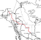
The Pan-American Highway is a network of roads measuring about in total length. Except for an rainforest break, called the Darién Gap, the road links the mainland nations of the Americas in a connected highway system. According to Guinness World Records, the Pan-American Highway is the world's...
route in North America is the portion of a network of roads nearly 48,000 km in length which travels through the mainland nations of the Americas.
No definitive length of the Pan American Highway exists because the U.S. and Canadian governments have never officially defined any specific routes as being part of the Pan-American Highway, and Mexico officially has many branches connecting to the U.S. border. However, the total length of the North American portion of the highway is roughly 16000 miles (25,749.4 km).
Partial lengths (with references):
- Length: 162 miles (260.7 km) (from Circle to Fairbanks)
- Length: 980 km (608.9 mi) (from Fairbanks, Alaska to Whitehorse, Yukon)
- Length: 1890 km (1,174.4 mi) (from: Whitehorse, Yukon to Prince George, B. C.)
- Length: 778 km (from Prince George, B.C. to Vancouver, B.C.) (unofficial)
- Length: 276.62 miles (total length of I-5 in Washington) (unofficial)
- Length: 308.14 miles (total length of I-5 in Oregon) (unofficial)
- Length: 796.53 miles (total length of I-5 in California) (unofficial)
United States (Alaska)
- Prudhoe Bay, Alaska
The Pan-American Highway unofficially begins in Prudhoe Bay
Prudhoe Bay, Alaska
Prudhoe Bay or Sagavanirktok is a census-designated place located in North Slope Borough in the U.S. state of Alaska. As of the 2010 census, the population of the CDP was 2,174 people; however, at any given time several thousand transient workers support the Prudhoe Bay oil field...
, Alaska near Deadhorse. Traveling south to Fairbanks
Fairbanks, Alaska
Fairbanks is a home rule city in and the borough seat of the Fairbanks North Star Borough in the U.S. state of Alaska.Fairbanks is the largest city in the Interior region of Alaska, and second largest in the state behind Anchorage...
, Alaska follows the length of the Dalton Highway
Dalton Highway
The James W. Dalton Highway, usually Dalton Highway is a 414-mile road in Alaska. It begins at the Elliott Highway, north of Fairbanks, and ends at Deadhorse near the Arctic Ocean and the Prudhoe Bay oil fields...
(Alaska Route 11) and Alaska Route 2
Alaska Route 2
Alaska Route 2 is a state highway in the central and east-central portions of the U.S. state of Alaska. It runs from Manley Hot Springs via Fairbanks to the Yukon Territory, including the entire length of the Alaska Highway in the state.-Route description:...
.
- Fairbanks
From Alaska's third largest city, the Pan-American Highway and the Alaska Highway
Alaska Highway
The Alaska Highway was constructed during World War II for the purpose of connecting the contiguous U.S. to Alaska through Canada. It begins at the junction with several Canadian highways in Dawson Creek, British Columbia and runs to Delta Junction, Alaska, via Whitehorse, Yukon...
are one and the same, following Alaska Route 2 southeast to the Canadian border southeast of Northway
Northway, Alaska
Northway is a census-designated place in Southeast Fairbanks Census Area, Alaska, United States. The population was 95 at the 2000 census.-Geography:Northway is located at ....
, Alaska, and adjacent to the Tetlin National Wildlife Refuge
Tetlin National Wildlife Refuge
Tetlin National Wildlife Refuge is a dynamic landscape made up of forests, wetlands, tundra, lakes, mountains and glacial rivers bounded by the snowy peaks of the Alaska Range. This upper Tanana River valley has been called the "Tetlin Passage," because it serves as a major migratory route for...
.
Note: The Pan-American Highway reenters the U.S., potentially in several locations along the U.S.-Canadian border.
Canada
Yukon Yukon Road Map
Crossing the border into Canada, Alaska Highway 2 turns into Yukon Highway 1
Alaska Highway
The Alaska Highway was constructed during World War II for the purpose of connecting the contiguous U.S. to Alaska through Canada. It begins at the junction with several Canadian highways in Dawson Creek, British Columbia and runs to Delta Junction, Alaska, via Whitehorse, Yukon...
. The first significant settlement along the way is Beaver Creek, Yukon
Beaver Creek, Yukon
- External links :* *...
.
- Haines Junction
At Haines Junction, where it meets Yukon Highway 3
Haines Highway
The Haines Highway or Haines Cut-Off is a highway that connects Haines, Alaska, in the United States, with Haines Junction, Yukon, Canada, passing through the province of British Columbia. It follows the route of the old Dalton Trail from the port of Haines inland for about to Klukshu, Yukon, and...
, Yukon Highway 1 turns east toward Whitehorse
Whitehorse, Yukon
Whitehorse is Yukon's capital and largest city . It was incorporated in 1950 and is located at kilometre 1476 on the Alaska Highway in southern Yukon. Whitehorse's downtown and Riverdale areas occupy both shores of the Yukon River, which originates in British Columbia and meets the Bering Sea in...
, the capital of the Yukon Territory.
- Whitehorse
Through most of Whitehorse, Yukon Highway 2
Klondike Highway
The Klondike Highway links the Alaskan coastal town of Skagway to Yukon's Dawson City and its route somewhat parallels that used by prospectors in the 1898 Klondike Gold Rush....
and Yukon Highway 1 share an alignment. Yukon Highway 1 cuts southeast toward Marsh Lake, Yukon
Marsh Lake, Yukon
Marsh Lake is an unincorporated bedroom community on the Alaska Highway on the shores of Marsh Lake southeast of Whitehorse in Canada's Yukon. The area was organized in 2001, as a local area council to help the residents with some form of municipal government....
while Yukon Highway 2 cuts south to Skagway
Skagway, Alaska
Skagway is a first-class borough in Alaska, on the Alaska Panhandle. It was formerly a city first incorporated in 1900 that was re-incorporated as a borough on June 25, 2007. As of the 2000 census, the population of the city was 862...
, Alaska. Eventually, Yukon Highway 1 intersects with Yukon Highway 8
Tagish Road
The Tagish Road is a 33-mile road, now hard surfaced, that links Jake's Corner on the Alaska Highway with Carcross, Yukon on the Klondike Highway. One mile from Jake's Corner is the terminus of the Atlin Road...
and Yukon Highway 7
Atlin Road
The Atlin Road is a road in British Columbia and Yukon, Canada. It is designated as Highway 7 in Yukon, and has no official highway number in British Columbia....
at Jake's Corner, Yukon; the highways continues on Yukon 1 east-northeast from this junction.
- Johnsons Crossing
At Johnson's Crossing, Yukon Highway 1 meets Yukon Highway 6
Canol Road
The Canol Road was part of a project to build a pipeline and a road from Norman Wells, Northwest Territories to Whitehorse, Yukon during World War II. The pipeline no longer exists, but the long Yukon portion of the road is maintained by the Yukon Government during summer months...
and travels southeast through Teslin, Yukon
Teslin, Yukon
The community of Teslin includes the Village of Teslin and an adjacent Indian Reserve in the Yukon, Canada. Teslin is situated at historical Mile 804 on the Alaska Highway along Teslin Lake. The Hudson's Bay Company established a small trading post at Teslin in 1903...
. The highway continues on Yukon 1 as it crosses over into British Columbia
British Columbia
British Columbia is the westernmost of Canada's provinces and is known for its natural beauty, as reflected in its Latin motto, Splendor sine occasu . Its name was chosen by Queen Victoria in 1858...
. After several miles, the highway reenters the Yukon (once again as Highway 1) and continues on Yukon 1 southeast of Watson Lake
Watson Lake, Yukon
Watson Lake is a town at historical mile 635 on the Alaska Highway in the southeastern Yukon close to the British Columbia border. Population in December 2004 was 1,547 ....
until it once again enters British Columbia as B.C. Highway 97.
British Columbia British Columbia Road Map
- Lower Post
After travelling about 5 miles (8 km) past the B.C.-Yukon border, the Pan-American Highway reaches the first settlement in British Columbia at Lower Post
Lower Post, British Columbia
Lower Post is an aboriginal community in northwestern British Columbia, Canada, located on Highway 97, the Alaska Highway, approximately 15 miles southeast of Watson Lake, Yukon. Its historical mile designation is Mile 620...
. After travelling about 20 miles (32.2 km) roughly east, the highway once again reenters the Yukon for roughly 8 miles (12.9 km). The highway then reenters British Columbia (as B.C. 97) for the final time. The Pan-American Highway continues south to southeast through a long, uninhabited stretch until it passes through the villages of Fireside and Coal River. Keep following the highway east along the Rabbit River
Rabbit River
The Rabbit River is a tributary of the Kalamazoo River within Allegan County in the U.S. state of Michigan. The river's watershed covers of land and drains most of north-central and northeast Allegan County as well as small portions of Barry, Kent and Ottawa counties.The river rises in farmland...
.
- Liard River
Roughly 8 miles (12.9 km) south of Liard River
Liard River, British Columbia
Liard River is a small community in northern British Columbia, Canada. It has a population of about 100 people. It is located at Kilometre 799 of the Alaska Highway, near the border of British Columbia and the Yukon Territory....
is Muncho Lake Provincial Park
Muncho Lake Provincial Park
Muncho Lake Provincial Park is a provincial park in British Columbia, Canada, located on the Alaska Highway as it transits the northernmost Canadian Rockies west of Fort Nelson. The park is part of the larger Muskwa-Kechika Management Area....
. The highway continues on B.C. Highway 97 as it passes through Toad River Post. Eventually it passes through Summit Lake, which is nested between Stone Mountain and Mount Saint George. Further down the road, B.C. Highway 97 intersects with B.C. Highway 77; the highway continues along B.C. 97 east to Fort Nelson
Fort Nelson, British Columbia
Fort Nelson is a town of approximately 5000 residents in British Columbia's northeastern corner. It is the administrative centre of the newly formed Northern Rockies Regional Municipality, a first for BC. The majority of Fort Nelson's economic activities have historically been concentrated in the...
.
- Fort Nelson
From Fort Nelson, the highway travels south for roughly 180 miles (289.7 km) until it reaches Fort St. John
Fort St. John, British Columbia
The City of Fort St. John is a city in northeastern British Columbia, Canada. A member municipality of the Peace River Regional District, the city covers an area of about 22 km² with 22,000 residents . Located at Mile 47, it is one of the largest cities along the Alaska Highway. Originally...
.
- Fort St. John
Once the Pan-American Highway reaches Fort St. John, the highway traveler has already nearly completed a large stretch of their travels through North America. The highway continues on B.C. Highway 97 southeast for another 38 miles (61.2 km) to reach the end of the Alaska Highway at Dawson Creek
Dawson Creek, British Columbia
Dawson Creek is a small city in northeastern British Columbia, Canada. The municipality of had a population of 11,529 in 2009. Dawson Creek derives its name from the creek of the same name that runs through the community. The creek was named after George Mercer Dawson by a member of his land...
.
Canada's length of the Pan-American Highway is not officially defined beyond the end of the Alaska Highway.
United States (Contiguous)
Note: The Pan-American Highway is almost never referred to by name in the U.S. Additionally, it may have multiple branches.Many roads in the United States are considered to be a part of the Pan-American Highway, but no one route has been officially declared.
In 1932, a bill introduced to the U.S. Congress proposed, among other roads, a route from Duluth
Duluth, Minnesota
Duluth is a port city in the U.S. state of Minnesota and is the county seat of Saint Louis County. The fourth largest city in Minnesota, Duluth had a total population of 86,265 in the 2010 census. Duluth is also the second largest city that is located on Lake Superior after Thunder Bay, Ontario,...
, Minnesota, to Laredo
Laredo, Texas
Laredo is the county seat of Webb County, Texas, United States, located on the north bank of the Rio Grande in South Texas, across from Nuevo Laredo, Tamaulipas, Mexico. According to the 2010 census, the city population was 236,091 making it the 3rd largest on the United States-Mexican border,...
, Texas, to connect with the Pan-American Highway in Mexico; this route probably followed today's Interstate 35
Interstate 35
Interstate 35 is a north–south Interstate Highway in the central United States. I-35 stretches from Laredo, Texas, on the U.S.-Mexico border to Duluth, Minnesota, at Minnesota Highway 61 and 26th Avenue East. Many interstates used to have splits or spurs indicated with suffixed letters , but I-35...
. When the section of Interstate 35
Interstate 35
Interstate 35 is a north–south Interstate Highway in the central United States. I-35 stretches from Laredo, Texas, on the U.S.-Mexico border to Duluth, Minnesota, at Minnesota Highway 61 and 26th Avenue East. Many interstates used to have splits or spurs indicated with suffixed letters , but I-35...
in San Antonio, Texas was built, it was named the Pan Am Expressway, as it lies along this route. However, this route was never officially named the Pan-American Highway
Pan-American Highway
The Pan-American Highway is a network of roads measuring about in total length. Except for an rainforest break, called the Darién Gap, the road links the mainland nations of the Americas in a connected highway system. According to Guinness World Records, the Pan-American Highway is the world's...
.
Interstate 25 in Albuquerque is named the Pan-American Freeway, and it along with part of Interstate 10
Interstate 10
Interstate 10 is the fourth-longest Interstate Highway in the United States, after I-90, I-80, and I-40. It is the southernmost east–west, coast-to-coast Interstate Highway, although I-4 and I-8 are further south. It stretches from the Pacific Ocean at State Route 1 in Santa Monica,...
and U.S. Route 85
U.S. Route 85
U.S. Route 85 is a north–south United States highway that runs for in the Mountain - Northern Plains states of the United States. The southern terminus of the route is at the United States-Mexico border in El Paso, Texas, connecting with Mexican Federal Highway 45...
are officially parts of the CanAm Highway
CanAm Highway
CanAm Highway passes through these states in the United States; Texas, New Mexico, Colorado, Wyoming, South Dakota, North Dakota, as well as the province of Saskatchewan, Canada. The international Can-Am Highway travels along U.S. Route 85 and Interstate 25, connecting Mexico to Canada through...
.
U.S. Route 81
U.S. Route 81
U.S. Route 81 is one of the many United States Numbered Highways established in 1926 by the US Department of Agriculture Bureau of Public Roads....
claims to be part of the Pan American Highway from Wichita
Wichita, Kansas
Wichita is the largest city in the U.S. state of Kansas.As of the 2010 census, the city population was 382,368. Located in south-central Kansas on the Arkansas River, Wichita is the county seat of Sedgwick County and the principal city of the Wichita metropolitan area...
, Kansas to Watertown
Watertown, South Dakota
Watertown is a city in and the county seat of Codington County, South Dakota, United States. The population was 21,482 at the 2010 census. It is also the principal city of the Watertown Micropolitan Statistical Area, which includes all of Codington and Hamlin counties...
, South Dakota.
The proposed Interstate 69
Interstate 69
Interstate 69 is an Interstate Highway in the United States. It exists in two parts: a completed highway from Indianapolis, Indiana, northeast to the Canadian border in Port Huron, Michigan, and a mostly proposed extension southwest to the Mexican border in Texas...
extension from the Canadian Border in Michigan
Michigan
Michigan is a U.S. state located in the Great Lakes Region of the United States of America. The name Michigan is the French form of the Ojibwa word mishigamaa, meaning "large water" or "large lake"....
to Mexican Border in south Texas has been referred to as the NAFTA Superhighway
NAFTA superhighway
The NAFTA superhighway is a term sometimes used to refer to certain existing and proposed highways. The beliefs associated with this appellation have been characterized as a part of theories of a conspiracy to undermine U.S...
, which will link to an official branch of the Pan-American Highway after crossing the border between Laredo
Laredo, Texas
Laredo is the county seat of Webb County, Texas, United States, located on the north bank of the Rio Grande in South Texas, across from Nuevo Laredo, Tamaulipas, Mexico. According to the 2010 census, the city population was 236,091 making it the 3rd largest on the United States-Mexican border,...
, Texas and Nuevo Laredo, Tamaulipas.
The Pan-American Highway unofficially has four terminals entering into Mexico, with the Inter-American Highway beginning at the border crossing between Laredo
Laredo, Texas
Laredo is the county seat of Webb County, Texas, United States, located on the north bank of the Rio Grande in South Texas, across from Nuevo Laredo, Tamaulipas, Mexico. According to the 2010 census, the city population was 236,091 making it the 3rd largest on the United States-Mexican border,...
, Texas, and Nuevo Laredo, Tamaulipas.
Mexico

- Nuevo Laredo, Tamaulipas
In Nuevo Laredo
Nuevo Laredo
Nuevo Laredo is a city located in the Municipality of Nuevo Laredo in the Mexican state of Tamaulipas. The city lies on the banks of the Río Grande, across from the United States city of Laredo, Texas. The 2010 census population of the city was 373,725. Nuevo Laredo is part of the Laredo-Nuevo...
, the Mexican Federal Highway 85
Mexican Federal Highway 85
Mexico's Federal Highway 85 connects Mexico City with the U.S. border at Nuevo Laredo, Tamaulipas. It is the original route of the Inter-American Highway. Highway 85 runs through Monterrey, Nuevo León; Ciudad Victoria, Tamaulipas; Ciudad Valles, San Luis Potosí; and Pachuca, Hidalgo...
splits into two routes to Monterrey the other being Mexican Federal Highway 85D
Mexican Federal Highway 85D
Mexican Federal Highway 85D is a pair of toll routes , one from Nuevo Laredo, Tamaulipas, to Monterrey, Nuevo León, known as Autopista Monterrey–Nuevo Laredo and the other from Pachuca, Hidalgo, to Mexico City, known as Autopista Pachuca–Ciudad de México. Both toll routes run parallel...
which has a toll of MXN$
Mexican peso
The peso is the currency of Mexico. Modern peso and dollar currencies have a common origin in the 15th–19th century Spanish dollar, most continuing to use its sign, "$". The Mexican peso is the 12th most traded currency in the world, the third most traded in the Americas, and by far the most...
177. Nuevo Laredo is a city with 348,387 inhabitants. The city is considered Latin America's largest inland port
Inland port
The term inland port is used in two different but related ways to mean either a port on an inland waterway or an inland site carrying out some functions of a seaport.- As a port on an inland waterway :...
with four international bridges
International bridges in Laredo, Texas
-Road bridges:-Proposed:-Rail bridges:-Proposed:...
into the USA. Monterrey is located some 225 km from Nuevo Laredo.
- Monterrey, Nuevo León
Monterrey
Monterrey
Monterrey , is the capital city of the northeastern state of Nuevo León in the country of Mexico. The city is anchor to the third-largest metropolitan area in Mexico and is ranked as the ninth-largest city in the nation. Monterrey serves as a commercial center in the north of the country and is the...
the third largest city in Mexico. Monterrey is a largely industrial city with approximately 4.5 million people. The Pan-American Highway continues south on Mexican Federal Highway 85
Mexican Federal Highway 85
Mexico's Federal Highway 85 connects Mexico City with the U.S. border at Nuevo Laredo, Tamaulipas. It is the original route of the Inter-American Highway. Highway 85 runs through Monterrey, Nuevo León; Ciudad Victoria, Tamaulipas; Ciudad Valles, San Luis Potosí; and Pachuca, Hidalgo...
, which is a divided limited-access highway until just past the village of Hualahuises
Hualahuises
Hualahuises is a small town in the state of Nuevo León, in northern Mexico. It serves as the administrative seat for the surrounding municipality, with which it shares a name....
. This is the beginning of the stretch of the Pan-American Highway known as the Inter-American Highway
Inter-American Highway
The Inter-American Highway is the Central American section of the Pan-American Highway and spans 3,400 miles between Nuevo Laredo, Mexico, and Panama City, Panama....
, which parallels and cuts through the Sierra Madre Oriental
Sierra Madre Oriental
The Sierra Madre Oriental is a mountain range in northeastern Mexico.-Setting:Spanning the Sierra Madre Oriental runs from Coahuila south through Nuevo León, southwest Tamaulipas, San Luis Potosí, Querétaro, and Hidalgo to northern Puebla, where it joins with the east-west running Eje Volcánico...
mountains.
From Monterrey to Hualahuises is about 65 miles (104.6 km). The highway continues south on Mexico 85 for another 85 miles (136.8 km) until it reaches Ciudad Victoria
Ciudad Victoria
Ciudad Victoria , is the capital city of the Mexican state ofTamaulipas. It is located in the western-central region of the state. Ciudad Victoria is also the municipal seat of the surrounding Victoria Municipality, which covers an area of 1,638 km²...
. About 15 miles (24.1 km) past the village of Linares
Linares, Nuevo León
Linares is a small city in the state of Nuevo León, Mexico. The city serves as the administrative centre for the surrounding municipality of the same name and it is the largest urban centre of the so called "orange belt" region. The city had a 2005 census population of 56,065, while the...
, the Inter-American Highway enters the state of Tamaulipas
Tamaulipas
Tamaulipas officially Estado Libre y Soberano de Tamaulipas is one of the 31 states which, with the Federal District, comprise the 32 Federal Entities of Mexico. It is divided in 43 municipalities and its capital city is Ciudad Victoria. The capital city was named after Guadalupe Victoria, the...
.
- Ciudad Victoria, Tamaulipas
From Ciudad Victoria
Ciudad Victoria
Ciudad Victoria , is the capital city of the Mexican state ofTamaulipas. It is located in the western-central region of the state. Ciudad Victoria is also the municipal seat of the surrounding Victoria Municipality, which covers an area of 1,638 km²...
, the highway continues south on Mexico 85; it is about 80 miles (128.7 km) to the next town, Ciudad Mante
Ciudad Mante
Mante formally Ciudad Mante is a city in the Mexican state of Tamaulipas. The city is the municipal seat of El Mante municipality in extreme southern Tamaulipas, and lies in the northwestern portion of the municipality. It had a 2005 census population of 81,884 inhabitants, or about 73 percent of...
. About 55 miles (88.5 km) south of Ciudad Mante is the town of Ciudad Valles
Ciudad Valles
Ciudad Valles is the second-largest city in the Mexican state of San Luis Potosí. It is located in the eastern part of the state at . The city is also the municipal seat of the surrounding municipality of the same name. The city had a 2005 census population of 116,261, while the municipality's...
; about halfway to Ciudad Valles, the Pan-American Highway enters the state of San Luis Potosí
San Luis Potosí
San Luis Potosí officially Estado Libre y Soberano de San Luis Potosí is one of the 31 states which, with the Federal District, comprise the 32 Federal Entities of Mexico. It is divided in 58 municipalities and its capital city is San Luis Potosí....
.
From Ciudad Valles to Zimapán is about 122 miles (196.3 km) of winding mountain road; Zimapán
Zimapan
Zimapan is a town and one of the 84 municipalities of Hidalgo, in central-eastern Mexico. The municipality covers an area of 860.9 km².As of 2005, the municipality had a total population of 34,476....
is in the state of Hidalgo. From Zimapán to the Hidalgo state capital of Pachuca
Pachuca
Pachuca, formally Pachuca de Soto is the capital of the Mexican state of Hidalgo. It is located in the south-central part of the state. Pachuca de Soto is also the name of the municipality of which the city serves as municipal seat...
is about 76 miles (122.3 km).
- Pachuca, Hidalgo
Upon entering Pachuca, the Pan-American Highway becomes a divided limited-access route. About 25 miles (40.2 km) southwest of Pachuca, Mexico 85 has an alternate toll route Mexican Federal Highway 85D
Mexican Federal Highway 85D
Mexican Federal Highway 85D is a pair of toll routes , one from Nuevo Laredo, Tamaulipas, to Monterrey, Nuevo León, known as Autopista Monterrey–Nuevo Laredo and the other from Pachuca, Hidalgo, to Mexico City, known as Autopista Pachuca–Ciudad de México. Both toll routes run parallel...
as it enters the state of México
Mexico (state)
México , officially: Estado Libre y Soberano de México is one of the 31 states which, with the Federal District, comprise the 32 Federal Entities of the United Mexican States. It is divided in 125 municipalities and its capital city is Toluca de Lerdo....
; for about another 25 miles (40.2 km). Teotihuacan
Teotihuacan
Teotihuacan – also written Teotihuacán, with a Spanish orthographic accent on the last syllable – is an enormous archaeological site in the Basin of Mexico, just 30 miles northeast of Mexico City, containing some of the largest pyramidal structures built in the pre-Columbian Americas...
ruins exist near the roadside along this stretch of the highway. The highway continues another 20 to 25 mi (32.2 to 40.2 km) before entering the Mexico City metropolitan area in the suburb of Ecatepec de Morelos
Ecatepec de Morelos
Ecatepec City, once officially San Cristóbal Ecatepec de Morelos, is a city in the State of México and the seat of Ecatepec de Morelos Municipality; however, both the city and the municipality are often known simply as "Ecatepec". The name "Ecatepec" is derived from Nahuatl, and means "windy hill"....
.
- Mexico City (La Ciudad de México)
The Pan-American Highway (as Mexico Highway 85D) enters Mexico City. Downtown Mexico City can be bypassed using Mexico Highway 136 (a divided limited-access route) and Mexico Highway 115, which reconnects to Mexico Highway 95D south of the Mexican Federal District.
- Cuernavaca, Morelos
As the Pan-American Highway continues south of Mexico City and the Distrito Federal (Federal District), the road arrives in the city of Cuernavaca
Cuernavaca
Cuernavaca is the capital and largest city of the state of Morelos in Mexico. It was established at the archeological site of Gualupita I by the Olmec, "the mother culture" of Mesoamerica, approximately 3200 years ago...
about 30 miles (48.3 km) south of the Mexican capital. Here, the Inter-American Highway section of the Pan-American Highway heads east along Federal Highway 190
Mexican Federal Highway 190
Mexican Federal Highway 190 is a Federal Highway of Mexico....
; for about 20 miles (32.2 km), it is a limited-access divided highway. Continue on Mexico 190 for the near duration; the road leaves the state of Puebla
Puebla
Puebla officially Estado Libre y Soberano de Puebla is one of the 31 states which, with the Federal District, comprise the 32 Federal Entities of Mexico. It is divided in 217 municipalities and its capital city is Puebla....
and enters the state of Oaxaca
Oaxaca
Oaxaca , , officially Estado Libre y Soberano de Oaxaca is one of the 31 states which, along with the Federal District, comprise the 32 federative entities of Mexico. It is divided into 571 municipalities; of which 418 are governed by the system of customs and traditions...
. From Huajuapan de León
Huajuapan de leon
Heroica Ciudad de Huajuapan de León; in , meaning Place of Brave People) is a rural city with a surrounding municipality located in the northwestern part of the Mexican state of Oaxaca....
to the Oaxaca state capital of Oaxaca
Oaxaca, Oaxaca
The city and municipality of Oaxaca de Juárez, or simply Oaxaca, is the capital and largest city of the Mexican state of the same name . It is located in the Centro District in the Central Valleys region of the state, in the foothills of the Sierra Madre at the base of the Cerro del Fortín...
is about 90 miles (144.8 km).
- Oaxaca, Oaxaca
From the city of Oaxaca, continue southeast on Mexico Highway 190. From Oaxaca to the village of Juchitán de Zaragoza
Juchitán de Zaragoza
Juchitán de Zaragoza is an indigenous town in the southeast of the Mexican state of Oaxaca.It is part of the Juchitán District in the west of the Istmo de Tehuantepec region...
is about 142 miles (228.5 km). The Pan-American Highway is now in southern Mexico, which is a combination of small mountains, hills, and jungle areas. It is another 56 miles (90.1 km) to the border with the state of Chiapas
Chiapas
Chiapas officially Estado Libre y Soberano de Chiapas is one of the 31 states that, with the Federal District, comprise the 32 Federal Entities of Mexico. It is divided in 118 municipalities and its capital city is Tuxtla Gutierrez. Other important cites in Chiapas include San Cristóbal de las...
and another trip across the Continental Divide
Continental Divide
The Continental Divide of the Americas, or merely the Continental Gulf of Division or Great Divide, is the name given to the principal, and largely mountainous, hydrological divide of the Americas that separates the watersheds that drain into the Pacific Ocean from those river systems that drain...
.
- Tuxtla Gutiérrez, Chiapas
From the Oaxaca-Chiapas state border, it is 100 miles (160.9 km) to the Chiapas state capital of Tuxtla Gutiérrez
Tuxtla Gutiérrez
Tuxtla Gutiérrez is the capital and largest city of the Mexican state of Chiapas. It is considered to be the state’s most modern city, with most of its public buildings dating from the 20th century. One exception to this is the San Marcos Cathedral which began as a Dominican parish church built in...
. Chiapas is an extremely impoverished region with relatively few services, especially outside of Tuxtla Gutiérrez. A large number of Chiapas residents are partly or completely of Mayan
Maya peoples
The Maya people constitute a diverse range of the Native American people of southern Mexico and northern Central America. The overarching term "Maya" is a collective designation to include the peoples of the region who share some degree of cultural and linguistic heritage; however, the term...
descent and do not speak Spanish, let alone English. Chiapas is also the home of the anti-Mexico City Zapatista Army of National Liberation
Zapatista Army of National Liberation
The Zapatista Army of National Liberation is a revolutionary leftist group based in Chiapas, the southernmost state of Mexico....
rebel group. The Highway crosses the Mexico-Guatemala border
Guatemala–Mexico border
The Guatemala–Mexico border is the international border between Guatemala and Mexico. It measures and runs between north and west Guatemala and the Mexican states of Quintana Roo, Campeche, Tabasco and Chiapas...
at Ciudad Cuauhtémoc
Ciudad Cuauhtémoc, Chiapas
Ciudad Cuauhtémoc is a city in the extreme southern Mexican state of Chiapas. It is part of the municipality of Frontera Comalapa and is situated on the Guatemala-Mexico border opposite the city of La Mesilla, Huehuetenango, Guatemala....
.
Guatemala
Upon crossing into Guatemala, Mexico Highway 190 transforms into Central America Highway 1. From the border village of La MesillaLa Mesilla
La Mesilla is a village in La Libertad municipality, Huehuetenango Department, Guatemala. It is the home of Peñarol La Mesilla football club.La Mesilla lies close to the border with Mexico, between Huehuetenango city and Comitán, Mexico.-External links:*...
to the city of Huehuetenango
Huehuetenango
Huehuetenango is a city and a municipality in the highlands of western Guatemala. It is also the capital of the department of Huehuetenango. The municipality's population was over 81,000 people in 2002...
is about 50 miles (80.5 km).
- Huehuetenango
A short distance from the Huehuetenago are the Maya
Maya civilization
The Maya is a Mesoamerican civilization, noted for the only known fully developed written language of the pre-Columbian Americas, as well as for its art, architecture, and mathematical and astronomical systems. Initially established during the Pre-Classic period The Maya is a Mesoamerican...
ruins of Zaculeu
Zaculeu
Zaculeu or Saqulew is a pre-Columbian Maya archaeological site in the highlands of western Guatemala, about outside of the modern city of Huehuetenango. Occupation at the site dates back as far as the Early Classic period of Mesoamerican history...
.
By the time it reaches Huehuetenango, the Pan-American Highway has to once again cross over the Continental Divide and into the Sierra de los Cuchumatanes
Sierra de los Cuchumatanes
The Sierra de los Cuchumatanes is the highest non-volcanic mountain range in Central America. Its elevations range from 500 m to over 3,800 m, and it covers a total area of ±16,350 km². With an area of 1,500 km² situated above 3,000 m, it is also the most extensive highland region in Central...
mountains.
- Chimaltenango
From Huehuetenango to Chimaltenango
Chimaltenango
Chimaltenango is a town in Guatemala of some 43,900 people . It serves as both the capital of the department of Chimaltenango and the municipal seat for the surrounding municipality of the same name....
is roughly 100 miles (160.9 km). On the way to Chimaltenango, there are some Mayan ruins at Iximché
Iximche
Iximche is a Pre-Columbian Mesoamerican archaeological site in the western highlands of Guatemala. Iximche was the capital of the Late Postclassic Kaqchikel Maya kingdom from 1470 until its abandonment in 1524. The architecture of the site included a number of pyramid-temples, palaces and two...
just north of Tecpán Guatemala. From Chimaltenango, it is only about 22 to 25 mi (35.4 to 40.2 km) to Guatemala City
Guatemala City
Guatemala City , is the capital and largest city of the Republic of Guatemala and Central America...
.
- Guatemala City (La Ciudad de Guatemala)
Guatemala City is the capital and largest city in Guatemala with a population between 1 and 2.5 million people; it is also the largest city in Central America. Guatemala City has several attractions, such as the Centro Cívico (Civic Center), Centro Cultural Miguel Ángel Asturias
Centro Cultural Miguel Ángel Asturias
The Centro Cultural Miguel Ángel Asturias, commonly named Teatro Nacional, is a cultural center in Guatemala City, Guatemala. It is located in the Centro Cívico of the city and was built in the same place of the old Fuerte de San José. Its form, which emulates a seated jaguar, stands out from the...
(national theater), the Jardín Botánico (Botanical Garden), Lake Amatitlán
Lake Amatitlán
Lake Amatitlán is a volcanic lake in south-central Guatemala, fairly close to Guatemala City. It lies in the central highlands, 1,186 m above sea level. Its maximum depth is 33 m and an average of 18 m...
(with a view of active volcanoes), the Mercado Central (Central Market with fruits and vegetables), Kaminal Juyú Mayan ruins, and the Zoológico La Aurora (Aurora Zoo).
From Guatemala City to Cuilapa
Cuilapa
Cuilapa, also known as Santa Rosa Cuilapa, is a town in Guatemala. It serves as the capital of the department of Santa Rosa and as the administrative seat for the surrounding municipality of Cuilapa.Cuilapa marks the midpoint of the American Continent....
is about 50 km (31.1 mi) and another 35 miles (56.3 km) to Jutiapa
Jutiapa
Jutiapa is a municipality in the Jutiapa department of Guatemala. Located 124 km from the city of Guatemala at an altitude of 892 m , it is the capital of the department of Jutiapa....
. The highway continues as CA Highway 1.
- Jutiapa
From Jutiapa, the Pan-American Highway approaches the border with El Salvador
El Salvador
El Salvador or simply Salvador is the smallest and the most densely populated country in Central America. The country's capital city and largest city is San Salvador; Santa Ana and San Miguel are also important cultural and commercial centers in the country and in all of Central America...
. It is 32 miles (51.5 km) to the border crossing at San Cristobal Frontera.
El Salvador
El Salvador is the smallest country (by area) that the Pan-American Highway travels through. After crossing into El Salvador at Candelaria de la Frontera, the Inter-American Highway continues on toward Santa AnaSanta Ana, El Salvador
Santa Ana is the second largest city in El Salvador, located 64 kilometers west of San Salvador, the capital city. Santa Ana has approximately 274,830 inhabitants and serves both as the capital of the department of Santa Ana and...
as Central America Highway 1. From the border crossing to Santa Ana is about 8 miles (12.9 km).
- Santa Ana
From Santa Ana to San Salvador is about 28 miles (45.1 km). At Nueva San Salvador, the traveler will pass near the Volcano de San Salvador.
- San Salvador
San Salvador, with a population of 402,448, is the capital and largest city in El Salvador. Some attractions are the New World Museum, Dixon Hill Lighthouse, and Watling's Castle, which is an old pirate hangout.
- San Miguel
From San Salvador to Cojutepeque is about 15 km (9.3 mi); following the highway southeast to San Miguel
San Miguel, El Salvador
San Miguel is the fourth most populous city in El Salvador after Santa Ana and Soyapango and the second most important after San Salvador. It is located 138 km east of the capital, San Salvador. It is also the capital of the department of San Miguel and a municipality...
is about 65 km (40.4 mi). From San Miguel to the El Salvador-Honduras border is about 30 km (18.6 mi).
Honduras
From the border with El Salvador, the Pan-American Highway doesn't spend much time in HondurasHonduras
Honduras is a republic in Central America. It was previously known as Spanish Honduras to differentiate it from British Honduras, which became the modern-day state of Belize...
. The highway's total distance in Honduras is about 65 miles (104.6 km).
From the border crossing to Nacaome
Nacaome
Nacaome is the capital city of the Valle department of Honduras. It is a manufacturing and commercial center located on the Nacaome River.Nacaome is an old city founded when aboriginal Cholulas and Chaparrastiques, tired of fighting each other, thought it best to join together to build new houses...
is only about 25 miles (40.2 km). Just past Nacaome is a highway traveling north to Tegucigalpa
Tegucigalpa
Tegucigalpa , and commonly referred as Tegus , is the capital of Honduras and seat of government of the Republic, along with its twin sister Comayagüela. Founded on September 29, 1578 by the Spanish, it became the country's capital on October 30, 1880 under President Marco Aurelio Soto...
, the capital of Honduras. It is about another 25 miles (40.2 km) to Choluteca
Choluteca, Choluteca
Choluteca is a municipality and the capital city of the Honduran department of the same name. Situated in southern Honduras between El Salvador and Nicaragua, the city is generally considered the regional center of southern Honduras and is a major transit point on the Pan-American Highway. It...
, the fourth largest city in Honduras. From Choluteca to the border crossing just past San Marcos de Colón is about 42 miles (67.6 km).
Nicaragua
From the crossing at the HondurasHonduras
Honduras is a republic in Central America. It was previously known as Spanish Honduras to differentiate it from British Honduras, which became the modern-day state of Belize...
-Nicaragua
Nicaragua
Nicaragua is the largest country in the Central American American isthmus, bordered by Honduras to the north and Costa Rica to the south. The country is situated between 11 and 14 degrees north of the Equator in the Northern Hemisphere, which places it entirely within the tropics. The Pacific Ocean...
border, the highway continues as Central America Highway 1. From the border to the town of Ocotal
Ocotal
Ocotal is the capital of the Nueva Segovia Department in Nicaragua, Central America.-Description:Ocotal is the capital of the Nueva Segovia Department in Nicaragua with light industry and crafts. The main agricultural production is coffee. The city, which has a population of 31,932 , is located...
is about 26 miles (41.8 km); from Ocotal to Estelí is about 36 miles (57.9 km).
Estelí
Estelí
Estelí, officially Villa de San Antonio de Pavia de Estelí is a city and municipality within the Estelí department. It is the third largest city in Nicaragua, an active commercial center in the north and is known as "the Diamond of the Segovias."...
to the village of Sébaco
Sébaco
Sébaco is a municipality in the Matagalpa department of Nicaragua.Situated at the junction of the Pan-American Highway and the Rio Grande de Matagalpa, Sébaco is the largest town of the agricultural valley of the same name. The Sébaco valley is some of the most fertile land in Nicaragua. Vegetable...
is about 46 km (28.6 mi); the Inter-American Highway turns from southeast to south towards Ciudad Darío
Ciudad Darío
Ciudad Darío is a municipality in the Matagalpa department of Nicaragua. It is the birthplace of poet Rubén Darío.Previously known as Metapa and Chocoyos even before that, Ciudad Darío is located 90 km from Managua...
, which is 15 km (9.3 mi) from Sébaco. From Ciudad Dario to the village of San Benito is 55 km (34.2 mi).
From San Benito, it is about 38 km (23.6 mi) to the Nicaraguan capital and largest city of Managua
Managua
Managua is the capital city of Nicaragua as well as the department and municipality by the same name. It is the largest city in Nicaragua in terms of population and geographic size. Located on the southwestern shore of Lake Xolotlán or Lake Managua, the city was declared the national capital in...
. Managua is located on the shores of Lake Managua
Lake Managua
Lake Managua is a lake in Nicaragua. The Spanish name is Lago de Managua or Lago Xolotlán. At 1,042 km², it is approximately long and wide. Similarly to the name of Lake Nicaragua, its name was coined by the Spanish conquerors from "Mangue" and agua...
and is about 35 miles (56.3 km) west of Lake Nicaragua
Lake Nicaragua
Lake Nicaragua or Cocibolca or Granada or is a vast freshwater lake in Nicaragua of tectonic origin. With an area of , it is the largest lake in Central America, the 19th largest lake in the world and the 9th largest in the Americas. It is slightly smaller than Lake Titicaca. With an elevation...
. Attractions include the Plaza de la República, which includes a lakeside cathedral
Cathedral
A cathedral is a Christian church that contains the seat of a bishop...
, the Palacio Nacional (National Palace),
the Ancient footprints of Acahualinca
Ancient footprints of Acahualinca
The Ancient footprints of Acahualinca exist in Managua, Nicaragua near the southern shore of Lake Managua . The region was once called "El Cauce"...
(Huellas de Acahualinca) museum, and the Museo de la Revolución (Nicaragua) (Museum of the Revolution). From Managua south to the town of Jinotepe is about 30 miles (48.3 km).
Jinotepe
Jinotepe
Jinotepe is a city in Nicaragua, located in Department of Carazo in the South Pacific region of Nicaragua at the municipality of Jinotepe. It borders with Managua, Masaya, Granada, and Rivas.It is a sister city of Santa Cruz, California, United States....
to the town of Rivas is about 70 km (43.5 mi). Around this area the Highway is in view of the shores of Lake Nicaragua, which is the largest lake in Central America. From Rivas to the Nicaragua-Costa Rica border is about 22 miles (35.4 km).
Costa Rica
Costa RicaCosta Rica
Costa Rica , officially the Republic of Costa Rica is a multilingual, multiethnic and multicultural country in Central America, bordered by Nicaragua to the north, Panama to the southeast, the Pacific Ocean to the west and the Caribbean Sea to the east....
contrasts sharply to the other nations in Central America, as it is a so-called second-world developing country compared to its underdeveloped, poorer neighbor Nicaragua. Costa Rica is the second-smallest Central American country in area (after El Salvador
El Salvador
El Salvador or simply Salvador is the smallest and the most densely populated country in Central America. The country's capital city and largest city is San Salvador; Santa Ana and San Miguel are also important cultural and commercial centers in the country and in all of Central America...
). Its portion of the Pan-American Highway, however, is still a minimally maintained twisty two-lane road, at least between San José
San José, Costa Rica
San José is the capital and largest city of Costa Rica. Located in the Central Valley, San José is the seat of national government, the focal point of political and economic activity, and the major transportation hub of this Central American nation.Founded in 1738 by order of Cabildo de León, San...
and the Nicaragua
Nicaragua
Nicaragua is the largest country in the Central American American isthmus, bordered by Honduras to the north and Costa Rica to the south. The country is situated between 11 and 14 degrees north of the Equator in the Northern Hemisphere, which places it entirely within the tropics. The Pacific Ocean...
border. Soon after entering Costa Rica the highway separates two national parks, the Santa Rosa National Park
Santa Rosa National Park
Santa Rosa National Park, in Spanish the , is a national park, part of the Area de Conservación Guanacaste World Heritage site, in the northern western part of Costa Rica, originally created to protect the scene of the Battle of Santa Rosa, at its eastern edge lies the Interamerican Highway where...
to the west and Guanacaste National Park
Guanacaste National Park (Costa Rica)
Guanacaste National Park, in Spanish , is part of the Area de Conservación Guanacaste World Heritage Site, is a National Park in the northern part of Costa Rica, from the slopes of the Orosí and Cacao volcanoes west to the Interamerican Highway where it is adjacent to the Santa Rosa National Park....
to the east.
From the Nicaragua-Costa Rica border to the town of Liberia is about 45 miles (72.4 km). In the region of Costa Rica, the Pan-American Highway runs just west of the Cordillera de Guanacaste (Guanacaste Mountains), which includes the active volcano
Volcano
2. Bedrock3. Conduit 4. Base5. Sill6. Dike7. Layers of ash emitted by the volcano8. Flank| 9. Layers of lava emitted by the volcano10. Throat11. Parasitic cone12. Lava flow13. Vent14. Crater15...
es of Rincón de la Vieja
Rincón de la Vieja Volcano
Rincón de la Vieja is an active andesitic complex volcano in north-western Costa Rica, about 25 km from Liberia, in the province of Guanacaste. Its name means "The Old Woman's Corner", a reference to a local legend about a girl whose lover was thrown into the crater by her father; she became a...
and Miravalles
Miravalles Volcano
The Miravalles Volcano is an andesitic stratovolcano in Costa Rica. The caldera was formed during several major explosive eruptions that produced voluminous dacitic-rhyolitic pyroclastic flows between about 1.5 and 0.6 million years ago. The only reported historical eruptive activity was a...
. While travelling through Costa Rica, the highway route is known as Costa Rica Highway 1 instead of CA Highway 1.http://www.transito.go.cr/estadorutas/index.html
Liberia
Liberia, Costa Rica
Liberia is the capital and largest city of Guanacaste province, Costa Rica, located northwest of the national capital, San José.-Summary:With more than 35,000 inhabitants, Liberia is the regional hub of the Costa Rican northwest. The city center features a modern church, as many Costa Rican towns...
to the town of Barranca is about 65 miles (104.6 km). From Barranca, the Cordillera de Tilarán (Tilarán Mountains) can be seen from the Pan-American Highway. The Tilarán range includes Arenal
Arenal Volcano
Arenal Volcano, in Spanish , is an active andesitic stratovolcano in north-western Costa Rica around 90 km northwest of San José, in the province of Alajuela, canton of San Carlos, and district of La Fortuna....
, one of the world's most active volcanoes. From Barranca, the highway heads east across the mountains and the Continental Divide
Continental Divide
The Continental Divide of the Americas, or merely the Continental Gulf of Division or Great Divide, is the name given to the principal, and largely mountainous, hydrological divide of the Americas that separates the watersheds that drain into the Pacific Ocean from those river systems that drain...
once again. From Barranca, it is roughly 44 miles (70.8 km) to the town of Alajuela.
After Alajuela
Alajuela
Alajuela is the second largest city in Costa Rica after the capital, San José. It is also the capital of the namesake province. Because of its location in the Costa Rican Central Valley, Alajuela is nowadays englobed in the conurbation of Great Metropolitan Area...
the Cordillera Central
Cordillera Central, Costa Rica
The Cordillera Central is a volcanic mountain range in central Costa Rica which continues the Continental Divide east of Cordillera de Tilarán. It extends 80 km from Tapezco Pass to the Turrialba Volcano and ending on the Pacuare River...
(Central Mountains) come into view from the Inter-American Highway. The Central Mountains include four large volcanoes--Poás
Poás Volcano
The Poás Volcano, in Spanish Volcán Poás, is an active stratovolcano in central Costa Rica. Poás has erupted 39 times since 1828.- Crater lakes :...
, Barva
Barva Volcano
Barva Volcano, sometimes called "Las Tres Marías" is an andesitic shield complex in central Costa Rica 22 km north of San José, in the province of Heredia. It sits on the small agricultural community of Sacramento....
, Irazú
Irazú Volcano
The Irazú Volcano is an active volcano in Costa Rica, situated in the Cordillera Central close to the city of Cartago.The name could come from either the combination of "ara" and "tzu" or a corruption of Iztarú, which was the name of an indigenous village on the flanks of the volcano...
and Turrialba
Turrialba Volcano
Turrialba Volcano was named after the region of Costa Rica in which the volcano is situated in Turrialba County, Cartago of Costa Rica. There is no clear consensus on the origin of the name Turrialba, but historians disagree with attempts to attribute the name to the patronym Torrealba or from...
. From Alajuela to San José is about 15 miles (24.1 km).
San José
San José, Costa Rica
San José is the capital and largest city of Costa Rica. Located in the Central Valley, San José is the seat of national government, the focal point of political and economic activity, and the major transportation hub of this Central American nation.Founded in 1738 by order of Cabildo de León, San...
is the capital and largest city in Costa Rica. Although San José is more modern than other large Central American cities with its shopping malls, department stores, and even fast food restaurants, it also includes several museums. These include the Museo Nacional (National Museum), the Museo del Oro Precolombino (Museum of Pre-Columbian Gold), the Museo de Jade (Jade
Jade
Jade is an ornamental stone.The term jade is applied to two different metamorphic rocks that are made up of different silicate minerals:...
Museum), the Teatro Nacional
Teatro Nacional de Costa Rica
The National Theatre of Costa Rica is the national theatre of Costa Rica. It is located in the central section of San José, Costa Rica. Construction began in 1891, and it opened to the public on 21 October 1897 with a performance of Johann Wolfgang von Goethe's Faust.The National Theatre stood as...
(National Theatre), and the Mercado Central (Central Market; open air).
Leaving San José, the Pan-American Highway winds its way roughly southeast. From San José to San Isidro de El General is about 84 miles (135.2 km).
From San Isidro, the Cordillera de Talamanca
Cordillera de Talamanca
The Cordillera de Talamanca is a mountain range that lies on the border between Costa Rica and Panama. Much of the range and the area around it is included in the La Amistad International Park, which also is shared between the two countries....
(Talamanca Mountains) rise up from the rain forest canopy. The Talamanca range, which is non-volcanic, includes Cerro Chirripó
Cerro Chirripó
Cerro Chirripó is the highest mountain in Costa Rica, with an altitude of . It is located in the Chirripó National Park and is noted for its ecological wealth. The high peaks in this and La Amistad International Park host important areas of Talamancan montane forest and Costa Rican Páramo with high...
. Cerro Chirripó, at 3820 metres (12,532.8 ft), is Costa Rica's highest mountain peak. From San Isidro to Palmar Sur is roughly 65 miles (104.6 km). Palmar Sur
Palmar Sur
Palmar Sur is a town in Costa Rica, located next to Palmar Norte in the Osa region of Puntarenas Province. Palmar Norte and Palmar Sur are separated by the Rio Terraba. Palmar Sur has a regional airport that has daily flights arriving from San Jose on two regional airlines...
to the Costa Rica-Panama border is about 55 miles (88.5 km).
Panama
The Pan-American Highway in PanamaPanama
Panama , officially the Republic of Panama , is the southernmost country of Central America. Situated on the isthmus connecting North and South America, it is bordered by Costa Rica to the northwest, Colombia to the southeast, the Caribbean Sea to the north and the Pacific Ocean to the south. The...
is being renovated and expanded to a four-lane Highway.
From the Costa Rica-Panama border to the village of La Concepción there is about 13 miles (20.9 km). From La Concepción to the city of David there is about another 15 miles (24.1 km). The highway enters Panama traveling generally from west to east.
- David
David, with an estimated population of 115,173, is located about 5 miles (8 km) north of the town of Pedregal and the Golfo de Chiriquí (Gulf of Chiriquí). David is the capital of the Chiriqui Province and is a center of trade for agricultural products such as bananas, sugar, and coffee, as well as smaller manufactured goods. From David, the highway travels east about 55 miles (88.5 km) to Tolé.
- Tolé
From Tolé to the town of Santiago is about 50 miles (80.5 km). Immediately east of Tolé, the highway crosses through some mountains for the next 36 miles (57.9 km). About halfway to Santiago, the Inter-American Highway crosses over the San Pablo river.
- Santiago (Panama)
From Santiago to Aguadulce is about 38 miles (61.2 km), where the Pan-American Highway (still CA Highway 1) reenters the tropical lowlands. From Aguadulce to Penonomé is roughly 30 miles (48.3 km). This stretch of highway crosses the Santa María river.
- Penonomé
From Penonomé, the highway travels southeast, then northeast, then roughly north in a loop as it mostly (but not completely) avoids crossing into Panama's Central Mountains. From Penonomé to La Chorerra is about 63 miles (101.4 km). From La Chorerra, it is only about 15 miles (24.1 km) to Balboa
Balboa, Panama
Balboa is a district of Panama City, located at the Pacific entrance to the Panama Canal.- History :The town of Balboa, founded by the United States during the construction of the Panama Canal, was named after Vasco Núñez de Balboa, the Spanish conquistador credited with discovering the Pacific Ocean...
just west of Panama City
Panama City
Panama is the capital and largest city of the Republic of Panama. It has a population of 880,691, with a total metro population of 1,272,672, and it is located at the Pacific entrance of the Panama Canal, in the province of the same name. The city is the political and administrative center of the...
.
- Panama CityPanama CityPanama is the capital and largest city of the Republic of Panama. It has a population of 880,691, with a total metro population of 1,272,672, and it is located at the Pacific entrance of the Panama Canal, in the province of the same name. The city is the political and administrative center of the...
Panama City, with a population of roughly 708,738, is the capital and largest city in Panama. Before entering the city, the Pan-American Highway crosses over the Panama Canal
Panama Canal
The Panama Canal is a ship canal in Panama that joins the Atlantic Ocean and the Pacific Ocean and is a key conduit for international maritime trade. Built from 1904 to 1914, the canal has seen annual traffic rise from about 1,000 ships early on to 14,702 vessels measuring a total of 309.6...
on the Centennial Bridge
Centennial Bridge, Panama
Panama's Centennial Bridge is a major bridge crossing the Panama Canal. It was built to supplement the overcrowded Bridge of the Americas, and to replace it as the carrier of the Pan-American Highway; upon its opening in 2004, it became only the second permanent crossing of the canal.-...
, which replaced the Bridge of the Americas
Bridge of the Americas
The Bridge of the Americas is a road bridge in Panama, which spans the Pacific entrance to the Panama Canal. Completed in 1962, at a cost of US$20 million, it was the only non-swinging bridge connecting the north and south American land masses until the opening of the Centennial Bridge in 2004...
as the major canal crossing in 2004. Panama City, compared to many other large Central American cities, is very modern. Some local attractions include the 17th-century Metropolitan Church, the Interoceanic Canal Museum of Panama, the Plaza de Bolívar, the Palacio de las Garzas (Heron's Palace or Presidential Palace), and the Panama Canal
Panama Canal
The Panama Canal is a ship canal in Panama that joins the Atlantic Ocean and the Pacific Ocean and is a key conduit for international maritime trade. Built from 1904 to 1914, the canal has seen annual traffic rise from about 1,000 ships early on to 14,702 vessels measuring a total of 309.6...
.
From Panama City, the highway turns northeast; from Panama City to Chepo is roughly 35 miles (56.3 km); from Chepo to Cañita is another 15 miles (24.1 km).
- Cañita
At the village of Cañita is the old terminus (end) of the northern route of the Pan-American Highway. Supposedly, the highway continues another 110 miles (177 km) past Cañita to the village of Yaviza. This stretch of highway is extremely remote.
- YavizaYavizaYaviza is a town in the Darién Province of Panama. The town marks the northwestern end of the Darién Gap of the Pan-American Highway. It has a population of 1,611 and is the main cultural center of the Panamanian side of the Darién Gap.- Sources :...
Yaviza is a village near the junction of the Tuira and Chucunaque rivers. It is here that the Inter-American Highway officially ends and, consequently, the northern Pan-American Highway. From Yaviza southeast lies the virtually impenetrable Darién Gap
Darién Gap
The Darién Gap is a large swath of undeveloped swampland and forest separating Panama's Darién Province in Central America from Colombia in South America. It measures just over long and about wide. Roadbuilding through this area is expensive, and the environmental toll is steep. Political...
, a 57-mile (92 km) stretch of rugged, mountainous jungle terrain.
Sources
- Plan Federal Highway System, New York Times, May 15, 1932 page XX7
- Reported from the Motor World, New York Times, January 26, 1936 page XX6
- Rand McNally Road Atlas, 1998 edition, p. 120, ISBN 0-528-83918-7
- Institute for Central American Studies – Costa Rica map
- Maps for DXers by Don Moore
- Road numbering systems by Marcel Monterie (links page)